Mangateretere

Last updated

Mangateretere
Rural community
Mangateretere
Coordinates: 39°37′08″S176°53′35″E / 39.619°S 176.893°E / -39.619; 176.893
Country New Zealand
Region Hawke's Bay
Territorial authority Hastings District
Ward
  • Heretaunga General Ward
  • Kahurānaki General Ward
  • Takitimu Māori Ward
Electorates
Government
  Territorial Authority Hastings District Council
  Regional council Hawke's Bay Regional Council
Postcode(s)
4180

Mangateretere is a rural community in the Hastings District and Hawke's Bay Region of New Zealand's North Island. The area is northeast of Hastings city and southwest of Clive.

Contents

The area was the Mangateretere Block in the 1860s. [1] 1,253 acres (507 ha) of this constituted the Mangateretere West Block which the Native Lands Court granted to Māori owners (including Karaitiana Takamoana) in 1866, and most of which were subsequently leased to a local farmer. [2] The Mangateretere East Block was a further 2,047 acres (828 ha). [3] Ownership of the blocks passed to the local farmer about 1869 in what appears to be a transaction where not all parties gave informed consent. [4] This was one of the transactions objected to by the Hawke's Bay Repudiation Movement of the 1870s. [5] At least part of the land was returned to Māori in 1883. [6]

Demographics

Mangateretere statistical area covers 39.94 km2 (15.42 sq mi) [7] and had an estimated population of 1,540 as of June 2023, [8] with a population density of 39 people per km2.

Historical population
YearPop.±% p.a.
2006981    
20131,053+1.02%
20181,149+1.76%
Source: [9]

Before the 2023 census, the statistical area had a smaller boundary, covering 37.22 km2 (14.37 sq mi). [7] Using that boundary, Mangateretere had a population of 1,149 at the 2018 New Zealand census, an increase of 96 people (9.1%) since the 2013 census, and an increase of 168 people (17.1%) since the 2006 census. There were 402 households, comprising 603 males and 543 females, giving a sex ratio of 1.11 males per female. The median age was 46.0 years (compared with 37.4 years nationally), with 204 people (17.8%) aged under 15 years, 192 (16.7%) aged 15 to 29, 558 (48.6%) aged 30 to 64, and 192 (16.7%) aged 65 or older.

Ethnicities were 91.1% European/Pākehā, 10.2% Māori, 2.3% Pacific peoples, 1.3% Asian, and 1.0% other ethnicities. People may identify with more than one ethnicity.

The percentage of people born overseas was 17.8, compared with 27.1% nationally.

Although some people chose not to answer the census's question about religious affiliation, 49.6% had no religion, 41.5% were Christian, 0.3% had Māori religious beliefs, 0.3% were Buddhist and 1.6% had other religions.

Of those at least 15 years old, 243 (25.7%) people had a bachelor's or higher degree, and 99 (10.5%) people had no formal qualifications. The median income was $35,700, compared with $31,800 nationally. 198 people (21.0%) earned over $70,000 compared to 17.2% nationally. The employment status of those at least 15 was that 492 (52.1%) people were employed full-time, 183 (19.4%) were part-time, and 12 (1.3%) were unemployed. [9]

Education

Mangateretere School (also called Te Kura o Mangateretere) is a co-educational state full primary school providing education for years 1–8, [10] with a roll of 27 as of February 2024. [11] [12] The school opened in 1903. [13]

Related Research Articles

Waipukurau is the largest town in the Central Hawke's Bay District on the east coast of the North Island of New Zealand. It is located on the banks of the Tukituki River, 7 kilometres south of Waipawa and 50 kilometres southwest of Hastings.

<span class="mw-page-title-main">Central Hawke's Bay District</span> Territorial authority district in Hawkes Bay, New Zealand

Central Hawke's Bay District is in the Hawke's Bay Region in the North Island of New Zealand. Formed in 1989, it covers an area of 3,333 square kilometres, from Pukehou in the north to Takapau in the south, and from the western Ruahine Range to the Pacific coast in the east. It has a population of 16,000, up from 14,142 in the 2018 census and 12,717 in the 2013 census.

<span class="mw-page-title-main">Waipawa</span> Town in Hawkes Bay, New Zealand

Waipawa is the second-largest town in Central Hawke's Bay in the east of the North Island of New Zealand. It has a population of 2,400.

<span class="mw-page-title-main">Pōrangahau</span> Settlement in Hawkes Bay Region, New Zealand

Pōrangahau is a small township close to the Pacific Ocean coast in the south-east of the North Island of New Zealand. It lies in the southernmost part of Hawke's Bay, 45 kilometres south of Waipukurau, and close to the mouth of the Porangahau River. The settlement includes a marae and a school.

<span class="mw-page-title-main">Clive, New Zealand</span> Town in New Zealand

Clive is a small town, ten kilometres from the city centres of both Napier and Hastings in the Hawke's Bay region of New Zealand's North Island. It is close to the mouth of the Ngaruroro River.

Flaxmere is a township in the Hastings District and outlying suburb of Hastings City, in the Hawke's Bay Region of New Zealand's North Island. It consists of a series of cul-de-sacs, radiating from a main street.

<span class="mw-page-title-main">Haumoana</span> Settlement in Hawkes Bay Region, New Zealand

Haumoana is a coastal town just south of the Tukituki River outlet in Hawke Bay on the east coast of New Zealand's North Island. It is located 12 km south of Napier and ten kilometres east of Hastings. The village incorporates a school, a Presbyterian Church, a general store, a takeaway shop, a hall and a fire station. The village was developed as a holiday settlement with beaches, and the surrounding area has historically been used for sheep and cattle grazing and horticulture. However, lifestyle blocks and grape growing have become more prominent in recent times. Many inhabitants commute to the nearby cities to work. There are approximately 430 houses in Haumoana. The population at the 2013 census was 2256, an increase of 54 people since 2006.

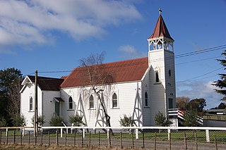
Ōtāne is a town in the Central Hawke's Bay District and the Hawke's Bay region, on the east coast of New Zealand's North Island. The small village, has a school, general store, cafe and pub, and is located just off State Highway 2.

Rahotu is a community in the west of Taranaki, in the North Island of New Zealand. It is located on State Highway 45, 16 kilometres north of Ōpunake and 11 km south of Warea.

Raureka is a suburb of Hastings City, in the Hawke's Bay Region of New Zealand's North Island.

Eskdale is a rural settlement in the Hastings District and Hawke's Bay region of New Zealand's North Island. It is located north of Napier on State Highway 5, near the mouth of the Esk River.

Pakowhai is a small settlement in the Hastings District and Hawke's Bay Region of New Zealand's North Island. It is a located between Napier and Hastings, north of the Ngaruroro River.

<span class="mw-page-title-main">Parkvale, Hastings</span> Suburb of Hastings, New Zealand

Parkvale is a suburb of Hastings City, in the Hawke's Bay Region of New Zealand's North Island.

Camberley is a suburb of Hastings City, in the Hawke's Bay Region of New Zealand's North Island.

Frimley is a suburb of Hastings City, in the Hawke's Bay Region of New Zealand's North Island.

Mayfair is a suburb of Hastings City, in the Hawke's Bay Region of New Zealand's North Island.

<span class="mw-page-title-main">Hastings Central</span> Central Business District of Hastings, New Zealand

Hastings Central is the central suburb and business district of Hastings City, in the Hawke's Bay Region of New Zealand's North Island.

<span class="mw-page-title-main">Maraekakaho</span> Settlement in Hawkes Bay Region, New Zealand

Maraekakaho is a rural settlement in the Hastings District and Hawke's Bay Region of New Zealand's North Island.

Sherenden is a settlement in the Hastings District and Hawke's Bay Region of New Zealand's North Island.

Karamu is a rural community in the Hastings District and Hawke's Bay Region of New Zealand's North Island. The area is on the eastern outskirts of Hastings city.

References

  1. "The Thistle Act". Hawke's Bay Herald. 23 April 1867. p. 2.
  2. "Explanation". Hawke's Bay Herald. 13 September 1870. p. 3.
  3. "In the Supreme Court of New Zealand". Hawke's Bay Herald. 29 November 1870. p. 2.
  4. "Untitled". The Evening Post. 8 January 1872. p. 2.
  5. Pollock, Kerryn (1 July 2015). "Repudiation movement". Te Ara: The Encyclopedia of New Zealand.
  6. "Untitled". Hawke's Bay Herald. 22 December 1883. p. 2.
  7. 1 2 "ArcGIS Web Application". statsnz.maps.arcgis.com. Retrieved 22 April 2024.
  8. "Population estimate tables - NZ.Stat". Statistics New Zealand . Retrieved 25 October 2023.
  9. 1 2 "Statistical area 1 dataset for 2018 Census". Statistics New Zealand. March 2020. Mangateretere (211200). 2018 Census place summary: Mangateretere
  10. Education Counts: Mangateretere School
  11. "New Zealand Schools Directory". New Zealand Ministry of Education. Retrieved 14 March 2024.
  12. "Education Review Office Report". ero.govt.nz. Education Review Office.
  13. Mangateretere School 50th Anniversary 1903-1953. Swailes Printing Co. May 1953.