Eskdale, New Zealand

Last updated

Eskdale
Settlement
Eskdale, New Zealand
Coordinates: 39°24′12″S176°51′08″E / 39.403450°S 176.852263°E / -39.403450; 176.852263
CountryNew Zealand
Region Hawke's Bay Region
Territorial authority Hastings District
Ward
  • Mohaka General Ward
  • Takitimu Māori Ward
CommunityHastings District Rural Community
Electorates
Government
  Territorial Authority Hastings District Council
  Regional council Hawke's Bay Regional Council
Postcode(s)
4182

Eskdale is a rural settlement in the Hastings District and Hawke's Bay region of New Zealand's North Island. It is located north of Napier on State Highway 5, [1] near the mouth of the Esk River. [2]

Contents

Description and history

The valley has many vineyards, wineries, orchards and fishing spots. [2] The local Eskdale War Memorial Church was designed by James Chapman-Taylor, [3] and dedicated to Percival Moore Beattie, a local man killed during World War I. [4] [5]

The river has a history of flooding. [2] Flash flooding inundated the settlement in March 2018, [6] leaving most of the local holiday parks underwater. [7] Large parts of the valley were inundated during Cyclone Gabrielle in February 2023. The floods caused significant damage in the settlement, destroying houses and sections of State Highway 5 and the Palmerston North–Gisborne Railway Line. [8]

A wildfire broke out near Eskdale in March 2019. [9]

Demographics

Puketapu-Eskdale statistical area, which also includes Puketapu, Whirinaki and Waiohiki, covers 244.98 km2 (94.59 sq mi) [10] and had an estimated population of 3,120 as of June 2022, [11] with a population density of 13 people per km2.

Historical population for Puketapu-Eskdale
YearPop.±% p.a.
20062,052    
20132,184+0.89%
20182,673+4.12%
Source: [12]

Puketapu-Eskdale had a population of 2,673 at the 2018 New Zealand census, an increase of 489 people (22.4%) since the 2013 census, and an increase of 621 people (30.3%) since the 2006 census. There were 915 households, comprising 1,392 males and 1,284 females, giving a sex ratio of 1.08 males per female. The median age was 45.5 years (compared with 37.4 years nationally), with 480 people (18.0%) aged under 15 years, 414 (15.5%) aged 15 to 29, 1,395 (52.2%) aged 30 to 64, and 384 (14.4%) aged 65 or older.

Ethnicities were 88.3% European/Pākehā, 13.6% Māori, 5.2% Pacific peoples, 1.2% Asian, and 1.3% other ethnicities. People may identify with more than one ethnicity.

The percentage of people born overseas was 17.6, compared with 27.1% nationally.

Although some people chose not to answer the census's question about religious affiliation, 53.2% had no religion, 37.3% were Christian, 1.1% had Māori religious beliefs, 0.1% were Muslim, 0.3% were Buddhist and 1.8% had other religions.

Of those at least 15 years old, 453 (20.7%) people had a bachelor's or higher degree, and 348 (15.9%) people had no formal qualifications. The median income was $36,500, compared with $31,800 nationally. 495 people (22.6%) earned over $70,000 compared to 17.2% nationally. The employment status of those at least 15 was that 1,272 (58.0%) people were employed full-time, 363 (16.6%) were part-time, and 39 (1.8%) were unemployed. [12]

Education

Eskdale School is a co-educational state primary school, [13] with a roll of 281 as of April 2023. [14] [15] The school opened in 1859 and was redeveloped in the 1990s. [16]

Hukarere Girls' College is a single-sex state-integrated secondary school, [17] with a roll of 77 as of April 2023. [14] [18] The school was founded as Hukarere Native School for Girls in 1875 in Napier. It moved to its current site in 2003. It has strong ties to both the Anglican Church and to Māori culture. [19]

Related Research Articles

Waipukurau is the largest town in the Central Hawke's Bay District on the east coast of the North Island of New Zealand. It is located on the banks of the Tukituki River, 7 kilometres south of Waipawa and 50 kilometres southwest of Hastings.

<span class="mw-page-title-main">Wairoa</span> Town in Hawkes Bay, New Zealand

Wairoa is a town and territorial authority district in New Zealand's North Island. The town is the northernmost in the Hawke's Bay region, and is located on the northern shore of Hawke Bay at the mouth of the Wairoa River and to the west of Māhia Peninsula. It is on State Highway 2, 118 kilometres (73 mi) northeast of Napier, and 92 kilometres (57 mi) southwest of Gisborne. Wairoa is the nearest town to the Te Urewera protected area and former national park that is accessible from Wairoa via State Highway 38. It is the largest town in the district of Wairoa, and is one of three towns in New Zealand, the others being Kawerau and Opotiki, where Māori outnumber other ethnicities, with 62.29% of the population identifying as Māori.

<span class="mw-page-title-main">Clive, New Zealand</span> Town in New Zealand

Clive is a small town, ten kilometres from the city centres of both Napier and Hastings in the Hawke's Bay region of New Zealand's North Island. It is close to the mouth of the Ngaruroro River.

<span class="mw-page-title-main">Marton, New Zealand</span> Town in Manawatū-Whanganui, New Zealand

Marton is a town in the Rangitikei district of the Manawatū-Whanganui region of New Zealand's North Island. It is situated 35 kilometres southeast of Whanganui and 40 kilometres northwest of Palmerston North.

<span class="mw-page-title-main">Napier Hill</span> Suburb of Napier, New Zealand

Napier Hill is a limestone outcrop and suburb rising above the lowland districts of the city of Napier on New Zealand's North Island.

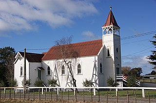
Ōtāne is a town in the Central Hawke's Bay District and the Hawke's Bay region, on the east coast of New Zealand's North Island. The small village, has a school, general store, cafe and pub, and is located just off State Highway 2.

Onekawa is a suburb of the city of Napier, in the Hawke's Bay Region of the eastern North Island of New Zealand. Development of the suburb began in the late 1940s, after the land was acquired from then-Harbour Board.

Maraenui is a suburb of the city of Napier, in the Hawke's Bay region of New Zealand's eastern North Island. The New Zealand Ministry for Culture and Heritage gives a translation of "great marae" for Maraenui.

The Esk River of Hawke's Bay, in the eastern North Island of New Zealand, one of two rivers of that name in the country, is one of Hawke's Bay's major rivers. It flows south from the slopes of Taraponui in the Maungaharuru Range before turning east to reach Hawke Bay 10 kilometres (6 mi) north of Napier. State Highway 5 follows the lower course of the river for several kilometres close to the settlement of Eskdale. The river is probably named after the Esk River in southern Scotland and north-west England.

Hukarere Girls' College is a girls secondary boarding school in the Hawke's Bay Region of New Zealand. It has a strong Māori character and follows the Anglican tradition. The School motto "Kia Ū Ki Te Pai" means "Cleave to that which is good" or "Abhor that which is evil".

<span class="mw-page-title-main">Welcome Bay</span> Suburb of Tauranga, New Zealand

Welcome Bay is a suburb of Tauranga, New Zealand. It is located 7 kilometres (4.3 mi) from central Tauranga. Neighbouring suburbs include Hairini and Maungatapu. There are a number of schools in Welcome Bay, including three primary schools.

Puketapu is a rural community in the Hastings District and Hawke's Bay Region of New Zealand's North Island.

Omakere is a farming settlement in the Central Hawke's Bay District and Hawke's Bay Region of New Zealand's North Island. It is located east of Waipawa.

Pakowhai is a small settlement in the Hastings District and Hawke's Bay Region of New Zealand's North Island. It is a located between Napier and Hastings, north of the Ngaruroro River.

Tamatea is a suburb in the west of the city of Napier, in the Hawke's Bay Region of New Zealand's eastern North Island.

Te Awa is a suburb of the city of Napier, in the Hawke's Bay region of New Zealand's eastern North Island.

Marewa is a suburb of the city of Napier, in the Hawke's Bay Region of New Zealand's eastern North Island. Development of the suburb began in 1934, after the 1931 Hawke's Bay earthquake raised the previously low lying swamp land.

<span class="mw-page-title-main">Meeanee, New Zealand</span> Suburb of Napier, New Zealand

Meeanee is a locality south of the city of Napier, in the Hawke's Bay Region on the east coast of New Zealand's North Island. It was named after the Battle of Meeanee in India, won by Sir Charles Napier, the city's namesake. Along with such locations as Clive and Havelock North, it is one of several places within Hawke's Bay to be named after events or people in Colonial India.

<span class="mw-page-title-main">Maraekakaho</span> Settlement in Hawkes Bay Region, New Zealand

Maraekakaho is a rural settlement in the Hastings District and Hawke's Bay Region of New Zealand's North Island.

Omahu is a village in the Hastings District and Hawke's Bay Region of New Zealand's North Island. It is located on State Highway 50, north-west of Hastings on the north bank of the Ngaruroro River.

References

  1. Hariss, Gavin. "Eskdale, Hawke's Bay". topomap.co.nz. NZ Topo Map.
  2. 1 2 3 "Eskdale". nzhistory.govt.nz. Ministry for Culture and Heritage.
  3. Burgess, Linda (2015). Historic Churches: A Guide to Over 60 Early New Zealand Churches. Penguin Books. pp. 116–119. ISBN   978-1775537335.
  4. "Eskdale War Memorial Church". nzhistory.govt.nz. Ministry for Culture and Heritage.
  5. "Eskdale War Memorial Church". Hastings Standard. 4 December 1920.
  6. O'Sullivan, Patrick (8 March 2018). "Local Focus: Flash Flood shocks Eskdale residents". New Zealand Media and Entertainment. Hawke's Bay Today.
  7. Appleby, Luke (8 March 2018). "Breathtaking drone footage shows Napier holiday park's 'muddy mess' after flooded river rose by 7m in one-in-50-year event". Television New Zealand. 1 News.
  8. "Cyclone Gabrielle: Eskdale residents send desperate plea to emergency officials". Newshub.
  9. May, George (24 March 2019). "Bay View hill fire threatened homes: 'We were very lucky that it was a calm day'". New Zealand Media and Entertainment. Hawke's Bay Today.
  10. "ArcGIS Web Application". statsnz.maps.arcgis.com. Retrieved 31 January 2023.
  11. "Population estimate tables - NZ.Stat". Statistics New Zealand . Retrieved 25 October 2022.
  12. 1 2 "Statistical area 1 dataset for 2018 Census". Statistics New Zealand. March 2020. Puketapu-Eskdale (208300). 2018 Census place summary: Puketapu-Eskdale
  13. "Eskdale School Ministry of Education School Profile". educationcounts.govt.nz. Ministry of Education.
  14. 1 2 "New Zealand Schools Directory". New Zealand Ministry of Education. Retrieved 12 December 2022.
  15. "Eskdale School Education Review Office Report". ero.govt.nz. Education Review Office.
  16. Laing, Doug (26 October 2016). "New rooms pledged as regions' old schools grow". Hawkes Bay Today.
  17. "Hukarere Girls' College Ministry of Education School Profile". educationcounts.govt.nz. Ministry of Education.
  18. "Hukarere Girls' College Education Review Office Report". ero.govt.nz. Education Review Office.
  19. "Our Story". Hukarere Girls' College. Retrieved 1 February 2023.