
Dartmoor is an upland area in southern Devon, South West England. The moorland and surrounding land has been protected by National Park status since 1951. Dartmoor National Park covers 954 km2 (368 sq mi).

Hawke's Bay is a region on the east coast of New Zealand's North Island. The region is named for Hawke Bay, which was named in honour of Edward Hawke. The region's main centres are the cities of Napier and Hastings, while the more rural parts of the region are served by the towns of Waipukurau, Waipawa, and Wairoa.
The Heretaunga Plains is a 300 square kilometres (120 sq mi) alluvial plain at the southern end of Hawke Bay on the east coast of the North Island of New Zealand. The towns of Napier, Hastings and Havelock North are on the plain.

The Ahaura River is in the South Island of New Zealand. This river drains the western flanks of the Southern Alps and flows into the Grey River.

The Kaweka Range of mountains is located in inland Hawke's Bay in the eastern North Island of New Zealand. It forms part of the mountainous spine of the North Island which extends from Wellington to East Cape, including the Tararua and Ruahine ranges.

The Ngaruroro River is located in the eastern North Island of New Zealand. It runs for a total of 164 kilometres southeast from the Kaweka Range, Kaimanawa Range and Ruahine Range and then east before emptying into Hawke Bay roughly halfway between the cities of Napier and Hastings, near the town of Clive. About 40% of the catchment is pasture, and 55% native forest. The meaning of Ngaruroro is obscure.

Taradale is a suburb of the City of Napier, in the Hawke's Bay Region of the North Island of New Zealand. It is a predominantly middle-upper class residential suburb, located 10 kilometres southwest of the centre of Napier. The Taradale ward, which includes Greenmeadows, Meeanee, and Poraiti, had a population of 22,809 in the 2018 New Zealand census.
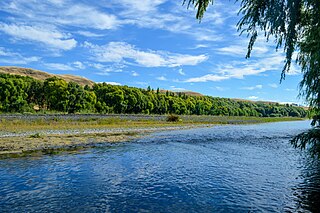
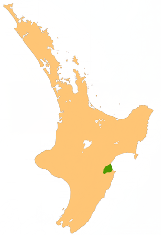
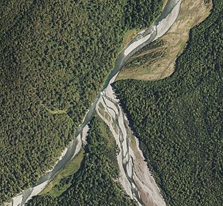
The Tutaekuri River flows eastward for 99.9 kilometres through the Hawke's Bay Region of the eastern North Island of New Zealand into the Pacific Ocean. It starts in the Kaweka Range roughly 50 kilometres north-east of Taihape, and reaches the sea just to the south of Napier, where the Ngaruroro and Clive Rivers join it.
The Trent River is a river of the West Coast Region of New Zealand's South Island. It flows east from its source in the Kaimata Range northeast of Otira, turning north to reach the valley of the Ahaura River via the Tūtaekurī River.

The Waiheke River is a river of the West Coast Region of New Zealand's South Island. It flows west from its origins on Mount Barron in the Southern Alps to reach the Ahaura River, which it forms where it joins the Tūtaekurī River, 20 kilometres northwest of Lake Sumner.
The Donald River is a river in the Hawke's Bay region of New Zealand. It flows southeast from the Kaweka Ranges in the Kaweka Forest Park, reaching the Tutaekuri River 20 kilometres (12 mi) west of Napier.

The Mangaone River is a river of the Hawke's Bay region of New Zealand's North Island. Its source is numerous streams draining the slopes of the Te Waka Range in the Rukumoana Forest area. The river flows southeast then south through rugged hill country until it meets the Tutaekuri River. For most of its course it is deeply incised in the tephra, ignimbrite and lapilli volcanic rocks, which are a bit over 30,000 years old. The deep valleys are partly due to the soft rocks and partly to the rapid rise of the Mohaka Fault, at over 3 mm (0.12 in) a year.

Ahuriri Lagoon was a large tidal lagoon at Napier, on the east coast of New Zealand's North Island, that largely drained when the area was raised by the 1931 Hawke's Bay earthquake.
Puketapu is a rural community in the Hastings District and Hawke's Bay Region of New Zealand's North Island.
Waiohiki is a rural community in the Hastings District and Hawke's Bay Region of New Zealand's North Island. It is located between the Ngaruroro and Tutaekuri Rivers, south of Taradale and north of Hastings on State Highway 50. Napier Golf Club is located at Waiohiki.
Ōnahau Bay is a large bay in Queen Charlotte Sound, New Zealand, just north-east of Grove Arm and meeting it at Houhou Point.

The Tutaekuri River, in the Wairoa District of New Zealand's Hawke's Bay, rises below Gaddum Road, in the Tutaekuri Conservation Area and flows about 24 km (15 mi) east before joining the Waiau River near Raumotu Bridge, about 3 km (1.9 mi) from its confluence with the Wairoa River at Frasertown.
The Tūtaekurī River starts near the Hope Pass, in the Southern Alps and flows north-west to join the Ahaura River. The Ahaura joins the Grey River which flows to the Tasman Sea at Greymouth. Tūtaekurī River has been its official name since 21 June 2019. Tūtae kurī is a grass with the latin name agropyron multiflorum.
