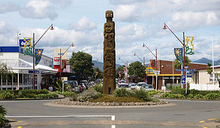
It is located inland from Wairoa at the junction of SH38, and the inland route (the Tiniroto Road; the former SH36) to Gisborne. State Highway 38 leads from Wai-O-Tapu via Murupara, The Ureweras, Lake Waikaremoana and Frasertown to Wairoa. It gives a short, but (partly) unsealed, winding and climbing connection to the Central North Island Rotorua. It is named for Major James Fraser, who led military forces in Wairoa in the 1860s.[3][4]
Demographics
Statistics New Zealand describes Frasertown as a rural settlement, which covers 1.36km2 (0.53sqmi)[1] and had an estimated population of 270 as of June 2023,[2] with a population density of 199 people per km2. It is part of the larger Frasertown-Ruakituri statistical area.
Frasertown had a population of 255 at the 2018 New Zealand census, an increase of 42 people (19.7%) since the 2013 census, and an increase of 3 people (1.2%) since the 2006 census. There were 93 households, comprising 120 males and 138 females, giving a sex ratio of 0.87 males per female, with 57 people (22.4%) aged under 15 years, 42 (16.5%) aged 15 to 29, 102 (40.0%) aged 30 to 64, and 54 (21.2%) aged 65 or older.
Ethnicities were 54.1% European/Pākehā, 56.5% Māori, 2.4% Pacific peoples, 1.2% Asian, and 1.2% other ethnicities. People may identify with more than one ethnicity.
Although some people chose not to answer the census's question about religious affiliation, 34.1% had no religion, 37.6% were Christian, 22.4% had Māori religious beliefs and 1.2% had other religions.
Of those at least 15 years old, 21 (10.6%) people had a bachelor's or higher degree, and 54 (27.3%) people had no formal qualifications. 21 people (10.6%) earned over $70,000 compared to 17.2% nationally. The employment status of those at least 15 was that 81 (40.9%) people were employed full-time, 36 (18.2%) were part-time, and 12 (6.1%) were unemployed.[5]
Frasertown-Ruakituri statistical area
Frasertown-Ruakituri statistical area, which also includes Ohuka and Ruakituri, covers 1,333.71km2 (514.95sqmi)[1] and had an estimated population of 940 as of June 2023,[6] with a population density of 0.70 people per km2.
Frasertown-Ruakituri had a population of 861 at the 2018 New Zealand census, unchanged since the 2013 census, and a decrease of 66 people (−7.1%) since the 2006 census. There were 324 households, comprising 444 males and 420 females, giving a sex ratio of 1.06 males per female. The median age was 39.0 years (compared with 37.4 years nationally), with 192 people (22.3%) aged under 15 years, 153 (17.8%) aged 15 to 29, 369 (42.9%) aged 30 to 64, and 147 (17.1%) aged 65 or older.
Ethnicities were 69.3% European/Pākehā, 45.6% Māori, 1.0% Pacific peoples, 0.3% Asian, and 1.0% other ethnicities. People may identify with more than one ethnicity.
The percentage of people born overseas was 4.5, compared with 27.1% nationally.
Although some people chose not to answer the census's question about religious affiliation, 44.6% had no religion, 38.0% were Christian, 10.8% had Māori religious beliefs and 0.3% had other religions.
Of those at least 15 years old, 72 (10.8%) people had a bachelor's or higher degree, and 162 (24.2%) people had no formal qualifications. The median income was $28,700, compared with $31,800 nationally. 75 people (11.2%) earned over $70,000 compared to 17.2% nationally. The employment status of those at least 15 was that 342 (51.1%) people were employed full-time, 123 (18.4%) were part-time, and 18 (2.7%) were unemployed.[7]
Marae
The township includes a number of marae (meeting grounds) and wharenui (meeting houses) for the local iwi (tribe) of Ngāti Kahungunu and its hapū (sub-tribes):[8][9]
Aranui Marae and Arapera or Te Poho o Ngapera wharenui, affiliated with Ngāi Tamaterangi and Ngāti Peehi hapū.
Pākōwhai Marae and Te Huinga o Te Aroha wharenui, affiliated with Ngāti Mihi hapū.
Pūtahi Marae and Te Poho o Hinepehinga wharenui, affiliated with Ngāti Hinepehinga hapū.
In October 2020, the Government committed $1,949,075 from the Provincial Growth Fund to upgrade all four marae and 20 other Ngāti Kahungunu marae, creating 164 jobs.[10]
Education
Frasertown School is a Year 1–6 co-educational state primary school.[11] It is a decile 4 school with a roll of 120 as of February 2024.[12][13]
Related Research Articles
Tokomaru Bay is a small beachside community on the remote East Coast of New Zealand's North Island. It is 91 km north of Gisborne, on State Highway 35, and close to Mount Hikurangi. The district was originally known as Toka-a-Namu, which refers to the abundance of sandflies. Over the years the name was altered to Tokomaru Bay.
Ōpōtiki is a town in the eastern Bay of Plenty in the North Island of New Zealand. It houses the headquarters of the Ōpōtiki District Council, the mayor of Ōpōtiki and comes under the Bay of Plenty Regional Council.
Māhia Peninsula is located on the east coast of New Zealand's North Island, in the Hawke's Bay region, between the towns of Wairoa and Gisborne.
Ngongotahā is a small settlement on the western shores of Lake Rotorua in the North Island of New Zealand. It is located 10 km (6.2 mi) northwest of the Rotorua central business district, and is considered as a suburb of Rotorua. It is part of the Rotorua functional urban area as defined by Statistics New Zealand. Ngongotahā has a population of 5,230 as of June 2023.
Tolaga Bay is both a bay and small town on the East Coast of New Zealand's North Island located 45 kilometres northeast of Gisborne and 30 kilometres south of Tokomaru Bay.
Kawhia Harbour is one of three large natural inlets in the Tasman Sea coast of the Waikato region of New Zealand's North Island. It is located to the south of Raglan Harbour, Ruapuke and Aotea Harbour, 40 kilometres southwest of Hamilton. Kawhia is part of the Ōtorohanga District and is in the King Country. It has a high-tide area of 68 km2 (26 sq mi) and a low-tide area of 18 km2 (6.9 sq mi). Te Motu Island is located in the harbour.
Arapuni is a rural town centre on the Waikato river in the South Waikato District of New Zealand. The town sits next to the Arapuni Dam, a hydroelectric dam at Lake Arapuni commissioned in 1929. The Arapuni Power Station consists of eight turbines which give a total output of 196 MW, the largest of the power stations on the Waikato river. The Arapuni hydro station is owned and operated by Mercury Energy.
Kaeo is a township in the Far North District of New Zealand, located some 22 km (14 mi) northwest of Kerikeri. The town's name comes from the Māori-language name of the New Zealand freshwater mussel, which is found in nearby rivers.
Raupunga is a small settlement in the northern Hawke's Bay Region of New Zealand's eastern North Island. It is located close to the country's highest railway bridge, the Mohaka Viaduct, which crosses the Mohaka River. The village has a predominantly Māori population as of the 2018 Census.
Nūhaka is a small settlement in the northern Hawke's Bay Region of New Zealand's eastern North Island, lying on State Highway 2 between Wairoa and Gisborne. The road to Mahia turns off the highway at Nūhaka.
Wharekahika or Hicks Bay is a bay and coastal area in the Gisborne District of the North Island of New Zealand. It is situated 150 km east of Ōpōtiki and 186 km north of Gisborne city, along State Highway 35 between Potaka and Te Araroa.
Te Karaka is a small settlement inland from Gisborne, in the northeast of New Zealand's North Island. It is located in the valley of the Waipaoa River close to its junction with its tributary, the Waihora River. Te Karaka is located on State Highway 2, and is the largest settlement between Gisborne and Ōpōtiki in the Bay of Plenty.
Piopio is a small town in the Waitomo District. It is situated on State Highway 3 approximately 23 km from Te Kūiti.
Manakau is a settlement situated in the Horowhenua District, located at the boundary of the Manawatū-Whanganui and Wellington regions of New Zealand's North Island. It lies 8 km north of Ōtaki and 12 km south of Levin, and is connected to both via State Highway 1, which skirts Manakau's western edge. The township is situated 5 km inland from the coast of the Tasman Sea.
Wairoa District is a territorial authority district within the Hawke's Bay Region in the North Island of New Zealand. The Wairoa District Council is headquartered in the largest town, Wairoa. The district covers the northern half of the Hawke's Bay coast, extending from Māhia Peninsula to Lake Waikaremoana, and south to the mouth of the Waikare River.
Waioeka is a rural community in the Ōpōtiki District and Bay of Plenty Region of New Zealand's North Island. It is on the east bank of the Waioeka River.
Ruakituri is a rural area in the northern Hawke's Bay region of New Zealand's eastern North Island, located north of Wairoa and west of Gisborne. The 2013 New Zealand census recorded 708 people living in the Ruakituri-Morere area.
Rotoiti is a settlement on the shore of Lake Rotoiti, in Rotorua Lakes within the Bay of Plenty Region of New Zealand's North Island.
Mourea is a settlement in Rotorua Lakes within the Bay of Plenty Region of New Zealand's North Island.
Tuai is a village and rural community located around Lake Whakamarino, in the Wairoa District of the Hawke's Bay Region, on New Zealand's North Island.
This page is based on this Wikipedia article Text is available under the CC BY-SA 4.0 license; additional terms may apply. Images, videos and audio are available under their respective licenses.