Related Research Articles

The River Parrett flows through the counties of Dorset and Somerset in South West England, from its source in the Thorney Mills springs in the hills around Chedington in Dorset. Flowing northwest through Somerset and the Somerset Levels to its mouth at Burnham-on-Sea, into the Bridgwater Bay nature reserve on the Bristol Channel, the Parrett and its tributaries drain an area of 660 square miles (1,700 km2) – about 50 per cent of Somerset's land area, with a population of 300,000.

The River Avon is a river in the southwest of England. To distinguish it from a number of other rivers of the same name, it is often called the Bristol Avon. The name 'Avon' is a cognate of the Welsh word afon, meaning 'river'.

The Somerset Levels are a coastal plain and wetland area of Somerset, England, running south from the Mendips to the Blackdown Hills.

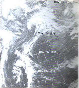
Storm tides of the North Sea are coastal floods associated with extratropical cyclones crossing over the North Sea, the severity of which is affected by the shallowness of the sea and the orientation of the shoreline relative to the storm's path, as well as the timing of tides. The water level can rise to more than 5 metres (17 ft) above the normal tide as a result of storm tides.
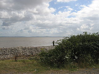
Bridgwater Bay is on the Bristol Channel, 5 kilometres (3.1 mi) north of Bridgwater in Somerset, England at the mouth of the River Parrett and the end of the River Parrett Trail. It stretches from Minehead at the southwestern end of the bay to Brean Down in the north. The area consists of large areas of mudflats, saltmarsh, sandflats and shingle ridges, some of which are vegetated. It has been designated as a Site of Special Scientific Interest (SSSI) covering an area of 3,574.1 hectares since 1989, and is designated as a wetland of international importance under the Ramsar Convention. The risks to wildlife are highlighted in the local Oil Spill Contingency Plan.

The Bristol Channel is a major inlet in the island of Great Britain, separating South Wales from Devon and Somerset in South West England. It extends from the lower estuary of the River Severn to the North Atlantic Ocean. It takes its name from the English city of Bristol, and is over 30 miles (50 km) wide at its western limit.

Burnham-on-Sea is a seaside town in Somerset, England, at the mouth of the River Parrett, upon Bridgwater Bay. Burnham was a small fishing village until the late 18th century when it began to grow because of its popularity as a seaside resort.

A storm surge, storm flood, tidal surge, or storm tide is a coastal flood or tsunami-like phenomenon of rising water commonly associated with low-pressure weather systems, such as cyclones. It is measured as the rise in water level above the normal tidal level, and does not include waves.

The Bristol Channel floods of 30 January 1607 drowned many people and destroyed a large amount of farmland and livestock during a flood in the Bristol Channel area of the UK. The known tide heights, probable weather, extent and depth of flooding, and coastal flooding elsewhere in the UK on the same day all point to the cause being a storm surge rather than a tsunami.

The Severn Barrage is any of a range of ideas for building a barrage from the English coast to the Welsh coast over the Severn tidal estuary. Ideas for damming or barraging the Severn estuary have existed since the 19th century. The building of such a barrage would constitute an engineering project comparable with some of the world's biggest. The purposes of such a project have typically been one or several of: transport links, flood protection, harbour creation, or tidal power generation. In recent decades it is the latter that has grown to be the primary focus for barrage ideas, and the others are now seen as useful side-effects. Following the Severn Tidal Power Feasibility Study (2008–10), the British government concluded that there was no strategic case for building a barrage but to continue to investigate emerging technologies. In June 2013 the Energy and Climate Change Select Committee published its findings after an eight-month study of the arguments for and against the Barrage. MPs said the case for the barrage was unproven. They were not convinced the economic case was strong enough and said the developer, Hafren Power, had failed to answer serious environmental and economic concerns.
The 1928 Thames flood was a disastrous flood of the River Thames that affected much of riverside London on 7 January 1928, as well as places further downriver. Fourteen people died and thousands were made homeless when floodwaters poured over the top of the Thames Embankment and part of the Chelsea Embankment collapsed. It was the last major flood to affect central London, and, along with the disastrous North Sea flood of 1953, helped lead to the implementation of new flood control measures that culminated in the construction of the Thames Barrier in the 1970s.

Birnbeck Pier, also known as the 'Old Pier', is a pier situated on the Bristol Channel in Weston-super-Mare, North Somerset, England, approximately 18 miles (29 km) south-west of Bristol. It is the only pier in the country which links the mainland to an island, linking to Birnbeck Island, a 1.2 hectares rocky island just to the west of Worlebury Hill. The grade II* listed pier was designed by Eugenius Birch and opened in 1867. Birnbeck Pier is one of only six Grade II* piers surviving in the country. The refreshment and waiting rooms of 1898 were designed by local architect Hans Price and the clocktower and the piermaster's house have been attributed to him. The pier has been closed to the public since 1994 and is now on the Buildings at Risk Register.

Burnham-on-Sea railway station was located within the town of Burnham-on-Sea, Somerset, and was the terminus of the Burnham branch of the Somerset and Dorset Joint Railway. Opened as Burnham by the Somerset Central Railway on 3 May 1858, it was renamed in 1920.
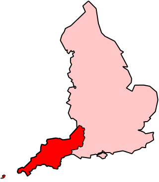
The climate of south-west England is classed as oceanic (Cfb) according to the Köppen climate classification. The oceanic climate is typified by frequent cloudy skies, cool winters with cool summers and precipitation all year round, with more experienced in winter. Annual rainfall is about 1,000 millimetres (39 in) and up to 2,000 millimetres (79 in) on higher ground. Summer maxima averages range from 18 °C (64 °F) to 22 °C (72 °F) and winter minima averages range from 1 °C (34 °F) to 4 °C (39 °F) across the south-west. It is the second windiest area of the United Kingdom, the majority of winds coming from the south-west and north-east. Government organisations predict the area will experience a rise in temperature and become the hottest region in the United Kingdom.

The Low Lighthouse is one of three historic lighthouses in Burnham-on-Sea, Somerset, England, and the only one of the three which is still active. It is a Grade II listed building and stands on the foreshore. First lit in 1832, the Low Lighthouse operated in conjunction with the (onshore) High Lighthouse for 137 years. Then, in 1969 the Low Lighthouse was deactivated; but later, in 1993, the Low Lighthouse was re-established and the High Lighthouse was instead decommissioned).

Burnham Area Rescue Boat (BARB), also known as BARB Search & Rescue, is a voluntary independent search and rescue service, formed in 1992 in Burnham-on-Sea, Somerset that operates two rescue hovercraft and two inshore rescue boats in the Bridgwater Bay area. It is also a registered charity.
The Gale of January 1976, widely known as the "Capella" storm in Germany and the Ruisbroek flood in Belgium, was one in a series of extratropical cyclones and storm surges, which occurred over January 1976. The gale of 2–5 January 1976 resulted in severe wind damage across western and central Europe and coastal flooding around the southern North Sea coasts. At the time, this was the most severe storm of the century over the British Isles. Total fatalities reached 82 across Europe, although a figure of 100 is given by the World Meteorological Organization. Of these 24 were reported in Britain and 4 in Ireland. Overall losses of US$1.3 billion were incurred, with insured losses standing at US$500 million (1976).

Cyclone Xaver, also known as the North Sea flood or tidal surge of 2013, was a winter storm that affected northern Europe. Force 12 winds and heavy snowfall were predicted along the storm's path, and there were warnings of a significant risk of storm surge leading to coastal flooding along the coasts of the North and Irish Seas.

Cyclone Anne was a European windstorm which caused €75 million in damage across western Europe in early January 2014, followed days later by Cyclone Christina.
References
- 1 2 Storm surge prediction in the Bristol Channel--the floods of 13 December 1981 R. Proctor, R.A. Flather, Continental Shelf Research, Volume 9, Issue 10, October 1989, Pages 889-918, ISSN 0278-4343, doi : 10.1016/0278-4343(89)90064-2, accessed 2011-03-25
- ↑ Philip Eden: Snowiest of 20th century- weatheronline.co.uk, accessed 2011-03-25
- ↑ Weather forecasters predict -12 tonight in Hampshire Southern Daily Echo, published 2010-12-02, accessed 2011-03-25
- ↑ "CLIMATE CHANGE ON THE SEVERN ESTUARY Sea level" (PDF). Severn Estuary Partnership. Archived from the original (PDF) on 16 May 2011. Retrieved 8 February 2012.
- 1 2 1981 Storm in photos - December 13th 1981 Archived 18 July 2012 at the Wayback Machine Burnham-On-Sea.com published 2006-12-13, accessed 2011-03-25
- ↑ "Somerset and the sea" (PDF). Environment Agency . Retrieved 5 December 2014.
- ↑ Inondations généralisées sur le Sud-Ouest Météo-France, accessed 2011-03-25
- ↑ "Guernsey lifeboat's 1981 rescue of Bonita crew remembered". BBC News. 13 December 2011. Retrieved 10 April 2012.
- ↑ "Storm event: 13TH DECEMBER 1981 Severe coastal floods in Somerset". www.surgewatch.org. Surgewatch.org. Retrieved 23 May 2015.
