Pacific Northwest windstorm

Last updated

Hanukkah Eve windstorm of 2006 off the Washington Coast on December 15, 2006, at 2:00 UTC. Infrared satellite image provided by the US Naval Research Labortory.jpg
Hanukkah Eve windstorm of 2006 off the Washington Coast on December 15, 2006, at 2:00 UTC.

Pacific Northwest windstorms, sometimes colloquially known as Big Blows, [1] are extratropical cyclones which form in the Pacific basin, and affect land areas in the Pacific Northwest of the United States and British Columbia, Canada. They form as cyclonic windstorms associated with areas of low atmospheric pressure that track across the North Pacific Ocean towards western North America. Deep low pressure areas are relatively common over the North Pacific. They are most common in the winter months. On average, the month when most windstorms form is November or December.

Contents

The closest analogue to these storms are European windstorms, which develop over the eastern portion of the North Atlantic Ocean as opposed to the North Pacific. [2] Nor'easters, a similar class of extratropical cyclones, commonly affect the east coast of North America. While the storms on the East Coast are named "nor'easters", the Pacific Northwest windstorms are not called "nor'westers" because the cyclones' primary winds can blow from any direction, while the primary winds in nor'easters usually blow from the northeast. [3]

Categories and frequency

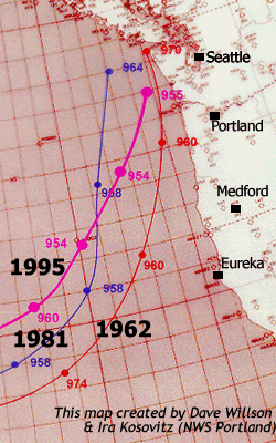
Storm tracks of the central low pressure of the storms which hit the Pacific Northwest in 1962, 1981 and 1995 Storm2.gif
Storm tracks of the central low pressure of the storms which hit the Pacific Northwest in 1962, 1981 and 1995
Office of Washington State Climatologist Windstorm Categories [4]
Average Peak Instant Gust (mph)Windstorm CategoryApproximate Return Interval
39-44MinorSeveral per year
45-54ModerateAnnual
55-64MajorOnce every 20–30 years
65-74ExtremeOnce every 50–100 years
75+PhenomenalOnce every 250–500 years

Notable Pacific Northwest windstorms

See also

Related Research Articles

<span class="mw-page-title-main">Nor'easter</span> Type of cyclone occurring in the northern Atlantic coast of North America

A nor'easter, or an East Coast low, is a synoptic-scale extratropical cyclone in the western North Atlantic Ocean. The name derives from the direction of the winds that blow from the northeast.

<span class="mw-page-title-main">Columbus Day Storm of 1962</span> Pacific Northwest windstorm

The Columbus Day Storm of 1962 was a Pacific Northwest windstorm that struck the West Coast of Canada and the Pacific Northwest coast of the United States on October 12, 1962. Typhoon Freda was the twenty-eighth tropical depression, the twenty-third tropical storm, and the eighteenth typhoon of the 1962 Pacific typhoon season. Freda originated from a tropical disturbance over the Northwest Pacific on September 28. On October 3, the system strengthened into a tropical storm and was given the name Freda, before becoming a typhoon later that day, while moving northeastward. The storm quickly intensified, reaching its peak as a Category 3-equivalent typhoon on October 5, with maximum 1-minute sustained winds of 115 mph (185 km/h) and a minimum central pressure of 948 millibars (28.0 inHg). Freda maintained its intensity for another day, before beginning to gradually weaken, later on October 6. On October 9, Freda weakened into a tropical storm, before transitioning into an extratropical cyclone on the next day. On October 11, Freda turned eastward and accelerated across the North Pacific, before striking the Pacific Northwest on the next day. On October 13, the cyclone made landfall on Washington and Vancouver Island, and then curved northwestward. Afterward, the system moved into Canada and weakened, before being absorbed by another developing storm to the south on October 17. The Columbus Day Storm of 1962 is considered to be the benchmark of extratropical wind storms. The storm ranks among the most intense to strike the region since at least 1948, likely since the January 9, 1880 "Great Gale" and snowstorm. The storm is a contender for the title of the most powerful extratropical cyclone recorded in the U.S. in the 20th century; with respect to wind velocity, it is unmatched by the March 1993 "Storm of the Century" and the "1991 Halloween Nor'easter". The system brought strong winds to the Pacific Northwest and southwest Canada, and was linked to 46 fatalities in the northwest and Northern California resulting from heavy rains and mudslides.

The Great Gale of 1880 was an intense extratropical cyclone that impacted the Northwest United States on January 9, 1880. Gusts of an estimated 138 miles per hour (222 km/h). Buildings, barns, and fences were destroyed. The storm blew a three-masted schooner onto the beach at Coos Bay where it broke in two.

<span class="mw-page-title-main">2003 Pacific typhoon season</span> Typhoon season in the Western Pacific Ocean

The 2003 Pacific typhoon season was a slightly below average yearlong period of tropical cyclogenesis exhibiting the development of 45 tropical depressions, of which 21 became named storms; of those, 14 became typhoons. Though every month with the exception of February and March featured tropical activity, most storms developed from May through October. During the season, tropical cyclones affected the Philippines, Japan, China, the Korean Peninsula, Indochina, and various islands in the western Pacific.

<span class="mw-page-title-main">2002 Pacific typhoon season</span> Typhoon season in the Western Pacific Ocean

The 2002 Pacific typhoon season was a slightly above average Pacific typhoon season, producing twenty-six named storms, fifteen becoming typhoons, and eight super typhoons. It had one of the highest ACE of any season worldwide, with over 400 units. It was an event in the annual cycle of tropical cyclone formation, in which tropical cyclones form in the western Pacific Ocean. The season ran throughout 2002, though most tropical cyclones typically develop between May and October. The season's first named storm, Tapah, developed on January 11, while the season's last named storm, Pongsona, dissipated on December 11. The season's first typhoon, Mitag, reached typhoon status on March 1, and became the first super typhoon of the year four days later.

<span class="mw-page-title-main">Typhoon Mireille</span> Pacific typhoon in 1991

Typhoon Mireille, known in the Philippines as Typhoon Rosing, was the costliest typhoon on record, until it was surpassed by Typhoon Hagibis in 2019. Striking Japan in September 1991, it became the 20th named storm of the 1991 Pacific typhoon season, Mireille formed on September 13 from the monsoon trough near the Marshall Islands. It moved westward for several days as a small system, steered by the subtropical ridge to the north. The storm rapidly intensified to typhoon status on September 16, and several days later passed north of Saipan in the Northern Marianas Islands. Mireille intensified further after deleterious effects from a nearby tropical storm subsided. On September 22, the American-based Joint Typhoon Warning Center (JTWC) estimated maximum 1-minute sustained winds of 240 km/h (150 mph), and on the next day, the official Japan Meteorological Agency (JMA) estimated 10‑minute sustained winds of 185 km/h (115 mph). The typhoon weakened slightly while turning northward, passing just east of Miyako-jima and later to the west of Okinawa. On September 27, Mireille made landfall near Nagasaki in southwestern Japan with winds of 175 km/h (109 mph), the strongest since Typhoon Nancy in 1961. The storm accelerated to the northeast through the Sea of Japan, moving over Hokkaido before becoming extratropical on September 28. The remnants of Mireille continued to the east, passing through the Aleutian Islands of Alaska on October 1.

A superstorm is a large, unusually occurring, destructive storm without another distinct meteorological classification, such as hurricane or blizzard.

<span class="mw-page-title-main">Hanukkah Eve windstorm of 2006</span>

The Hanukkah Eve windstorm of 2006 was a powerful Pacific Northwest windstorm in the Pacific Northwest region of the United States and southern British Columbia, Canada between December 14, 2006 and December 15, 2006. The storm produced hurricane-force wind gusts and heavy rainfall, causing hundreds of millions of dollars in damage and leaving over 1.8 million residences and businesses without power. Eighteen people were killed, most of whom died of carbon monoxide poisoning in the days following the storm because of improper use of barbecue cookers and generators indoors. The name of the storm was chosen in a contest run by the National Weather Service office in Seattle from about 8,000 entries.

<span class="mw-page-title-main">European windstorm</span> Strongest type of extratropical cyclone that occurs over Europe

European windstorms are powerful extratropical cyclones which form as cyclonic windstorms associated with areas of low atmospheric pressure. They can occur throughout the year, but are most frequent between October and March, with peak intensity in the winter months. Deep areas of low pressure are common over the North Atlantic, and occasionally start as nor'easters off the New England coast. They frequently track across the North Atlantic Ocean towards the north of Scotland and into the Norwegian Sea, which generally minimizes the impact to inland areas; however, if the track is further south, it may cause adverse weather conditions across Central Europe, Northern Europe and especially Western Europe. The countries most commonly affected include the United Kingdom, Ireland, the Netherlands, Norway, Germany, the Faroe Islands and Iceland.

<span class="mw-page-title-main">November 2011 Bering Sea cyclone</span>

The November 2011 Bering Sea cyclone was one of the most powerful extratropical cyclones to affect Alaska on record. On November 8, the National Weather Service (NWS) began issuing severe weather warnings, saying that this was a near-record storm in the Bering Sea. It rapidly deepened from 973 mb (28.7 inHg) to 948 mb (28.0 inHg) in just 24 hours before bottoming out at 943 mbar, roughly comparable to a Category 3 or 4 hurricane. The storm had been deemed life-threatening by many people. The storm had a forward speed of at least 60 mph (97 km/h) before it had reached Alaska. The storm began affecting Alaska in the late hours of November 8, 2011. The highest gust recorded was 93 mph (150 km/h) on Little Diomede Island. One person was reported missing after being swept into the Bering Sea, and he was later pronounced dead.

<span class="mw-page-title-main">March 2014 nor'easter</span> Noreaster in 2014

The March 2014 nor'easter was an extremely powerful extratropical cyclone that affected much of U.S. Gulf Coast, the eastern United States, eastern Canada, and Greenland. It was the most powerful winter storm of the 2013–14 North American winter storm season, being an unusually large winter storm as well, with its gale-force wind field becoming four times larger than that of Hurricane Sandy's extratropical remnant. The storm affected various parts of the Midwest, most of the Eastern Seaboard, as well as eastern Canada, bringing extremely powerful winds, and blizzard-like conditions.

<span class="mw-page-title-main">Typhoon Songda (2016)</span> Pacific typhoon in 2016

Typhoon Songda was the sixth most intense tropical cyclone of the Northwest Pacific Ocean in 2016. Also known as the Ides of October storm, it struck the Pacific Northwest region of the United States and Canada as a powerful extratropical cyclone. Songda was the twentieth named storm and the ninth typhoon of the annual typhoon season. The system developed into a tropical storm south of Minamitorishima on October 8 and strengthened into a typhoon on October 10. Songda reached its peak intensity southeast of Japan late on October 11 at an unusually high latitude, before it became extratropical on October 13.

<span class="mw-page-title-main">2017–18 North American winter</span> Weather summary

The 2017–18 North American winter saw weather patterns across North America that were very active, erratic, and protracted, especially near the end of the season, resulting in widespread snow and cold across the continent during the winter. Significant events included rare snowfall in the South, an outbreak of frigid temperatures that affected the United States during the final week of 2017 and early weeks of January, and a series of strong nor'easters that affected the Northeastern United States during the month of March. In addition, flooding also took place during the month of February in the Central United States. Finally the winter came to a conclusion with a powerful storm system that caused a tornado outbreak and blizzard in mid-April. The most intense event, however, was an extremely powerful cyclonic blizzard that impacted the Northeastern United States in the first week of 2018. Similar to the previous winter, a La Niña was expected to influence the winter weather across North America.

<span class="mw-page-title-main">Weather of 2020</span>

The following is a list of weather events that occurred on Earth in the year 2020.

<span class="mw-page-title-main">December 5–6, 2020, nor'easter</span> North American noreaster in 2020

The December 5–6, 2020 nor'easter brought heavy snowfall, hurricane-force wind gusts, blizzard conditions, and coastal flooding to much of New England in the first few days of December 2020. The system originated on the Mid-Atlantic coast late on December 4. It then moved up the East Coast of the United States from December 5–6, bombing out and bringing heavy wet snow to the New England states. It brought up to 18 inches (46 cm) of snow in northern New England, with widespread totals of 6–12 inches (15–30 cm) farther south.

<span class="mw-page-title-main">Miller Classification</span>

The Miller Classification is a technique that meteorologists use to classify nor'easters. The system splits nor'easters into five categories: Miller A, Miller B, Miller C, Miller D, and Miller E; the classification system initially started out with the first two categories. The system was derived by meteorologist and researcher J.E. Miller in 1946,.

<span class="mw-page-title-main">October 2017 North American storm complex</span> Meteorological bomb that affected United States and Canada

The October 2017 North American storm complex was a major explosive cyclogenesis storm, also called a bomb cyclone, in the Northeastern United States and Atlantic Canada from October 29–31, 2017. Forming from an extratropical cyclone on October 29 the system moved rapidly up the East Coast of the United States, bombing out with a minimum pressure of 975 millibars (28.8 inHg) on October 30. It brought heavy rain and extremely strong winds, and power outages, over 1.3 million customers being without power in the Northeast. Hurricane-force wind gusts resulted in downed trees, power lines, and widespread damage to buildings. The number of power outages in the state of Maine surpassed the Ice Storm of 1998.

<span class="mw-page-title-main">October 2021 nor'easter</span> Atlantic noreaster and tropical storm in 2021

The October 2021 nor'easter, which eventually became Tropical Storm Wanda, was an erratic nor'easter and tropical cyclone that struck the East Coast of the United States, and meandered across the northern Atlantic Ocean in early November 2021. The powerful extratropical cyclone affected much of the East Coast, causing significant flooding in areas which were previously affected by hurricanes Henri and Ida. As Wanda, the cyclone was the twenty-first and final tropical cyclone of the 2021 Atlantic hurricane season. The system originated from a non-tropical mid-level trough that moved across the Southern United States on October 24–25, and moved out into the Atlantic, where a well defined area of low pressure formed. This quickly became a bomb cyclone off the East Coast of the United States on October 27, causing flooding and bringing powerful gale-force winds to the region in the process. Then, on October 30, after weakening and moving eastward out into the Atlantic, the system acquired subtropical characteristics and was given the name Wanda. By 12:00 UTC on November 1, the system transitioned into a tropical storm. Over the next several days, Wanda meandering well west of the Azores, before curving southward and then accelerating northeastward, before degenerating into a post-tropical cyclone on November 7, several hours before merging with a frontal system.

<span class="mw-page-title-main">October 2021 Northeast Pacific bomb cyclone</span> North American bomb cyclone in 2021

An extremely powerful extratropical bomb cyclone began in late October 2021 in the Northeast Pacific and struck the Western United States and Western Canada. The storm was the third and the most powerful cyclone in a series of powerful storms that struck the region within a week. The cyclone tapped into a large atmospheric river and underwent explosive intensification, becoming a bomb cyclone on October 24. The bomb cyclone had a minimum central pressure of 942 millibars (27.8 inHg) at its peak, making it the most powerful cyclone recorded in the Northeast Pacific. The system had severe impacts across Western North America, before dissipating on October 26. The storm shattered multiple pressure records across parts of the Pacific Northwest. Additionally, the bomb cyclone was the most powerful storm on record to strike the region, in terms of minimum central pressure. The bomb cyclone brought powerful gale-force winds and flooding to portions of Western North America. At its height, the storm cut the power to over 370,500 customers across the Western U.S. and British Columbia. The storm killed at least two people; damage from the storm was estimated at several hundred million dollars. The bomb cyclone was compared to the Columbus Day Storm of 1962, in terms of ferocity.

References

  1. Knox, John A.; Frye, John D.; Durkee, Joshua D.; Fuhrmann, Christopher M. (2011). "Non-Convective High Winds Associated with Extratropical Cyclones". Geography Compass. 5 (2): 63–89. doi:10.1111/j.1749-8198.2010.00395.x . Retrieved April 16, 2013.
  2. Mass, Clifford; Dotson, Brigid (2010). "Major Extratropical Cyclones of the Northwest United States: Historical Review, Climatology, and Synoptic Environment". Monthly Weather Review. 138 (7): 2499–2527. Bibcode:2010MWRv..138.2499M. doi: 10.1175/2010MWR3213.1 . S2CID   19410610.
  3. Nic Loyd; Linda Weiford (November 4, 2021). "Weathercatch: The Northeast had a Nor'easter, why wasn't our storm a Nor'wester?". The Spokesman-Review. Retrieved November 4, 2021.
  4. "Some Historical Weather Events in the Pacific Northwest". Office of Washington State Climatologist. Retrieved April 15, 2013.
  5. Read, Wolf. "Two Windstorms in Three Days November 13–15, 1981". The Storm King, hosted by the Office of Washington State Climatologist. Retrieved April 17, 2013.
  6. "Wind Storms". Office of Emergency Management, Seattle. Retrieved April 15, 2013.
  7. "Washington's Top 10 Weather Events of 1900s". National Weather Service, Portland Oregon. Retrieved April 17, 2013.
  8. Read, Wolf. "The Major West Coast Windstorm of December 12, 1995". The Storm King, hosted by the Office of Washington State Climatologist. Retrieved April 14, 2013.
  9. Read, Wolf. "December 14-15, 2006 Windstorm". The Storm King, hosted by the Office of Washington State Climatologist. Retrieved April 14, 2013.
  10. Pawson, Chad (August 29, 2015). "B.C. Lower Mainland storm cuts power to 400,000 homes". CBC News. Retrieved October 14, 2017.
  11. "B.C. storm: 'Largest outage event' in BC Hydro history". CBC News. September 1, 2015. Retrieved October 14, 2017.
  12. "The mid-October windstorm in the Pacific Northwest | NOAA Climate.gov". www.climate.gov. October 28, 2016. Retrieved November 1, 2016.
  13. "December storm 'most damaging' in BC Hydro's history, report says". CBC News. January 2, 2019. Retrieved June 29, 2019.
  14. "In pictures: Powerful December windstorm blasts B.C.'s south coast | Globalnews.ca". globalnews.ca. December 20, 2018. Retrieved February 24, 2019.
  15. "Extratropical Cyclones Drench West Coast". earthobservatory.nasa.gov. October 25, 2021. Retrieved October 28, 2021.