Australian High

Last updated

Australian High
High pressure Area Sep 08 2012.jpg
The high featuring an anticlockwise rotation around an oval area of clear skies.
Area of occurrence
SeasonAll-year round
Effect
  • Drought in the west and south (summer)
  • Drier conditions, and at times drought, in the centre, north and east (winter)

The Australian High, also known as the Australian subtropical ridge, [1] is a large, semi-permanent high pressure area or subtropical anticyclone that seasonally vacillates between the Great Australian Bight in the south to the Northern Territory in the north. [2] It is generally located between 25 and 40 degrees of south latitude, depending on the season. [3] [4]

Contents

In summer, it typically sits over southern Australia as an Australian Bight High, [5] where it generally provides dry weather in the proximate region. In winter it normally moves north, therefore permitting cold fronts and low pressure systems to relocate up from the Great Australian Bight and bring rainfall to most parts of southern Australia. [6] The high is part of the subtropical ridge system and it is the reason why a large part of Australia is arid to semi-arid. [7]

Description

The Australian High west of Tasmania over the Indian Ocean High Pressure.jpg
The Australian High west of Tasmania over the Indian Ocean

The Australian High tends to follow the seasonal variation in position of the sun; it is strongest and most persistent during the southern hemisphere summer and weakest during winter when it shifts towards the interior of Australia, as the westerly frontal systems becomes more active in the region around the Bight, thereby allowing cold fronts and low-pressure systems to perforate the southern states. [8]

This high-pressure block exhibits anticyclonic behaviour, circulating the air anticlockwise. It remains almost stationary for a prolonged period over the Bight, hence obstructing the typical easterly procession of weather systems across southern Australia. [9]

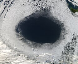
A cloud hole with an expansion as far as 1,000 kilometers (620 miles) has been observed, with tops of 1,040 millibars. The high may be extensive enough to interconnect with the Tasman High over in the Tasman Sea, just near New Zealand. [10] [11]

Effects

The high tends to keep the southern half of Australia mostly clear and dry. Australia.A2002231.0145.250m NASA Nullarbor.jpg
The high tends to keep the southern half of Australia mostly clear and dry.

The anticyclonic circulation produces a dry climate, bringing warm to hot weather in the southern Australian summer. The high influences the weather and climatic patterns of vast areas of Australia; The aridity of the Australian deserts and the summer drought of southern Australia is due to the large-scale subsidence and sinking motion of air in the system. [12]

In winter, when the high remains stationary in southern Australia (in a positive SAM phase), it can block or replace cold fronts from the Bight, thereby allowing warm weather to the southeast. [13] However, when the high remains fixed south of Western Australia, it can drive in polar air towards the continent, whereby increasing snowfall and rain in the southeast, particularly areas that lie west of the Great Dividing Range (due to the foehn effect). [14] Conversely, a large high stationed below South Australia can bring persistent rainfall to the east coast of Australia, whilst proving clear conditions to Tasmania. [15]

In the western part of the high, hot dry northerly winds from the dry centre push through South Australia and Victoria, ensuing heatwave conditions in these regions. The Australian High is one the drivers of the Southerly buster, which occurs in the southeast coast in the summer. [16] In winter, when the high pressure system is broad over the Australian landmass, widespread frost may occur. [17]

Effects on Asia

During the southern winter, the Australian High is one of the driving forces behind the South Asian Monsoon. Easterly winds blow from the center of the high towards Asia, and are deflected in a southwest direction towards India after crossing the equator due to the Coriolis effect.

Tasman High

Between summer and autumn, the high over southern Australia may be linked, or would intertwine, with the Tasman High in the southern Tasman Sea. When the high stalls in the Tasman Sea and becomes a blocking high, New Zealand and Tasmania will generally experience warm and generally dry weather, whilst the east coast of Australia (particularly southern Queensland and New South Wales) will experience moist onshore flows, particularly during a La Niña phase. [18] In March 2021, and also in February and March 2022, a stubborn blocking high in the south Tasman Sea caused heavy rain and flooding over large parts of Southeast Queensland and coastal New South Wales. [8] [19] [20]

See also

Related Research Articles

<span class="mw-page-title-main">Horse latitudes</span> Latitudes 30–35 degrees north and south of the Equator

The horse latitudes are the latitudes about 30 degrees north and south of the Equator. They are characterized by sunny skies, calm winds, and very little precipitation. They are also known as subtropical ridges or highs. It is a high-pressure area at the divergence of trade winds and the westerlies.

<span class="mw-page-title-main">Anticyclone</span> Weather phenomenon of high pressure, as opposed to a cyclone

An anticyclone is a weather phenomenon defined as a large-scale circulation of winds around a central region of high atmospheric pressure, clockwise in the Northern Hemisphere and counterclockwise in the Southern Hemisphere as viewed from above. Effects of surface-based anticyclones include clearing skies as well as cooler, drier air. Fog can also form overnight within a region of higher pressure.

<span class="mw-page-title-main">Mediterranean climate</span> Type of climate

A Mediterranean climate, also called a dry summer climate, described by Köppen as Cs, is a temperate climate type that occurs in the lower mid-latitudes. Such climates typically have dry summers and wet winters, with summer conditions being hot and winter conditions typically being mild. These weather conditions are typically experienced in the majority of Mediterranean-climate regions and countries, but remain highly dependent on proximity to the ocean, altitude and geographical location.

<span class="mw-page-title-main">Subtropics</span> Geographic and climate zone

The subtropical zones or subtropics are geographical and climate zones immediately to the north and south of the tropics. Geographically part of the temperate zones of both hemispheres, they cover the middle latitudes from 23°26′09.8″ (or 23.43605°) to approximately 35° north and south. The horse latitudes lie within this range.

<span class="mw-page-title-main">High-pressure area</span> Region with higher atmospheric pressure

A high-pressure area, high, or anticyclone, is an area near the surface of a planet where the atmospheric pressure is greater than the pressure in the surrounding regions. Highs are middle-scale meteorological features that result from interplays between the relatively larger-scale dynamics of an entire planet's atmospheric circulation.

The Siberian High is a massive collection of cold dry air that accumulates in the northeastern part of Eurasia from September until April. It is usually centered on Lake Baikal. It reaches its greatest size and strength in the winter when the air temperature near the center of the high-pressure area is often lower than −40 °C (−40 °F). The atmospheric pressure is often above 1,040 millibars (31 inHg). The Siberian High is the strongest semi-permanent high in the northern hemisphere and is responsible for both the lowest temperature in the Northern Hemisphere outside Greenland, of −67.8 °C (−90.0 °F) on 15 January 1885 at Verkhoyansk, and the highest pressure, 1083.8 mbar at Agata, Krasnoyarsk Krai, on 31 December 1968, ever recorded. The Siberian High is responsible both for severe winter cold and attendant dry conditions with little snow and few or no glaciers across Asian part of Russia, Mongolia, and China. During the summer, the Siberian High is largely replaced by the Asiatic low.

<span class="mw-page-title-main">Ridge (meteorology)</span> Elongated region of high atmospheric pressure

In meteorology a ridge or barometric ridge is an elongated area of relatively high atmospheric pressure compared to the surrounding environment, without being a closed circulation. It is associated with an area of maximum anticyclonic curvature of wind flow. The ridge originates in the center of an anticyclone and sandwiched between two low-pressure areas, and the locus of the maximum curvature is called the ridge line. This phenomenon is the opposite of a trough.

<span class="mw-page-title-main">Geography of New South Wales</span>

New South Wales is Australia's most populous state, located in the east coast of the continent. It is in the southern hemisphere between latitudes 28 and 38 degrees south of the equator and longitudes 141 and 154 degrees east of the Universal Prime Meridian. The state is in the warm temperate climatic zone.

<span class="mw-page-title-main">Block (meteorology)</span> Large-scale patterns in the atmospheric pressure field that are nearly stationary

Blocks in meteorology are large-scale patterns in the atmospheric pressure field that are nearly stationary, effectively "blocking" or redirecting migratory cyclones. They are also known as blocking highs or blocking anticyclones. These blocks can remain in place for several days or even weeks, causing the areas affected by them to have the same kind of weather for an extended period of time. In the Northern Hemisphere, extended blocking occurs most frequently in the spring over the eastern Pacific and Atlantic Oceans. Whilst these events are linked to the occurrence of extreme weather events such as heat waves, particularly the onset and decay of these events is still not well captured in numerical weather forecasts and remains an open area of research.

<span class="mw-page-title-main">Climate of Sydney</span>

The climate of Sydney, Australia is humid subtropical, shifting from mild and cool in winter to warm and occasionally hot in the summer, with no extreme seasonal differences since the weather has some maritime influence. Though more contrasting temperatures are recorded in the inland western suburbs, as Sydney CBD is more affected by the oceanic climate drivers than the hinterland.

<span class="mw-page-title-main">Azores High</span> High air pressure area in the Atlantic Ocean

The Azores High also known as North Atlantic (Subtropical) High/Anticyclone or the Bermuda-Azores High, is a large subtropical semi-permanent centre of high atmospheric pressure typically found south of the Azores in the Atlantic Ocean, at the Horse latitudes. It forms one pole of the North Atlantic oscillation, the other being the Icelandic Low. The system influences the weather and climatic patterns of vast areas of North Africa, Western Asia, Southern Europe, and to a lesser extent, eastern North America. The aridity of the Sahara Desert and the summer drought of the Mediterranean Basin is due to the large-scale subsidence and sinking motion of air in the system. In its summer position, the high is centered near Bermuda, and creates a southwest flow of hot tropical air toward the East Coast of the United States. In summer, the Azores-Bermuda High is strongest. The central pressure hovers around 1024 mbar (hPa).

<span class="mw-page-title-main">South Atlantic High</span> Semipermanent anticyclone over the Atlantic Ocean

South Atlantic High is a semipermanent pressure high centered at about 25°S, 15°W, in the Atlantic Ocean. It is also called the St. Helena High, Saint Helena island being the only land in the area. It can stretch thousands of miles across the South Atlantic. This does not mean that the position and the intensity of this anticyclone are permanent, but just that there is an anticyclone on the maps describing the average monthly pressure. This area of high pressure is part of the great subtropical belt of anticyclones called the subtropical ridge. The centre of the high pressure region tends to follow the seasonal variation in position of the sun, moving south in the southern summer and north in the southern winter. This affects the climate of the adjacent continental areas, bringing seasonal changes to the climate and weather as the position of the high oscillates.

<span class="mw-page-title-main">North American monsoon</span> Pattern of thunderstorms and rainfall in the southwestern United States and northwestern Mexico

The North American monsoon, variously known as the Southwest monsoon, the Mexican monsoon, the New Mexican monsoon, or the Arizona monsoon is a term for a pattern of pronounced increase in thunderstorms and rainfall over large areas of the southwestern United States and northwestern Mexico.

<span class="mw-page-title-main">Humid subtropical climate</span> Transitional climatic zone

A humid subtropical climate is a temperate climate type characterized by long and hot summers, and cool to mild winters. These climates normally lie on the southeast side of all continents, generally between latitudes 25° and 40° and are located poleward from adjacent tropical climates, and equatorward from either humid continental or oceanic climates. It is also known as warm temperate climate in some climate classifications.

<span class="mw-page-title-main">Australian east coast low</span> An extratropical cyclone on the coast of southeastern Australia

Australian east coast lows are extratropical cyclones or low-pressure systems on the coast of southeastern Australia that may be caused by both mid-latitude and tropical influences over a variety of levels in the atmosphere. These storms should not be confused with Australian region tropical cyclones which typically affect the northern half of the continent.

<span class="mw-page-title-main">Climate of Melbourne</span>

Melbourne, the state capital of Victoria and the second most populous city in Australia, has a temperate oceanic climate, bordering on a humid subtropical climate, and is well known for its changeable weather conditions. This is mainly due to Melbourne's geographical location. This temperature differential is most pronounced in the spring and summer months and can cause strong cold fronts to form. These cold fronts can be responsible for all sorts of severe weather from gales to severe thunderstorms and hail, minor temperature drops, and heavy rain. The city experiences little humidity in summer, except at the end of hot spells following thunderstorms and rain.

<span class="mw-page-title-main">Black nor'easter</span> Type of storm occurring in southeastern Australia

A black nor'easter is a persistent and potentially violent north-easterly storm that occurs on the east coast of Australia, particularly from southeastern Queensland to southern New South Wales, usually between late spring and early autumn, about two days a year.

<span class="mw-page-title-main">Australian Northwest Cloudband</span> Band of continuous cloud that stretches from the east Indian Ocean to southern Australia

The Australian Northwest Cloudband (NWCB), or just Northwest cloudband, is a band of a broad, continuous, moisture-laden cloud that stretches from the tropical east Indian Ocean to southern Australia, which forms in the cool season and generally brings sporadic precipitation across the Australian continent. The NWCB is the third most commonly occurring cloudband in the world and the fourth most frequently occurring cloudband in the Southern Hemisphere.

<span class="mw-page-title-main">Southeast Australian foehn</span> Weather event in Australia

The southeast Australian foehn is a westerly foehn wind and a rain shadow effect that usually occurs on the coastal plain of southern New South Wales, and as well as in southeastern Victoria and eastern Tasmania, on the leeward side of the Great Dividing Range.

2022 was an extremely wet year for Australia, coming out of a back-to-back La Niña in the summer of 2021-22, a Negative Indian Ocean Dipole developing over the winter and a third back-to-back La Niña in the spring of 2022.

References

  1. An assessment of relationships between the Australian subtropical ridge, rainfall variability and high-latitude circulation patterns by Dr Allyson A.J. Williams and Dr Roger C. Stone. Queensland Climate Change Centre of Excellence, Nambour, Queensland.
  2. An Australian "Anti-storm" EOS Project Science Office at NASA Goddard Space Flight Center. 5 June 2012.
  3. Summary of Weather Terms Bushwalking Leadership. Retrieved 7 April 2022.
  4. The Sub-tropical Ridge Bureau of Meteorology. Retrieved May 31, 2023
  5. Australian Bight High slows down GSC front runners and could reshuffle rankings by Marco Nannini from Global Solo Challenge. Retrieved 12 July 2024.
  6. Sub-tropical Ridge Example. Bureau of Meteorology. 2 April, 2008. Retrieved 31 May, 2023.
  7. Subtropical ridge leaves us high and dry this June Bureau of Meteorology. July 2017. Retrieved 31 May, 2023.
  8. 1 2 STALLED WEATHER: HOW STUCK AIR PRESSURE SYSTEMS DRIVE FLOODS AND HEATWAVES by Steve Turton from PreventionWeb.net. 3 March 2022
  9. Southern Annular Mode: The climate 'influencer' you may not have heard of By Kate Doyle from ABC. 14 August 2018. Retrieved 7 April 2022.
  10. High pressure systems: everything you need to know by Ben Domensino from Weatherzone. 21 May 2018. Retrieved 22 April 2022.
  11. THE CLIMATE KELPIE BLOG: Where have our winters gone? by Climate Kelpie. 6 May 2020.
  12. Extreme heat on its way to northwest WA by Ben Domensino from Weatherzone. 12 February 2022. Retrieved 7 April 2022.
  13. Sydney's record 15-day spell of 20 degree winter days by Ben Domensino from Weatherzone. 23 August 2021
  14. Australian snow, rain and heat linked by blocked weather systems, climatologist says By Ben Deacon from ABC Weather. 9 June 2022.
  15. Unrelenting high pressure dominating Australia’s weather by Ben Domensino from Weatherzone. 7 May 2024. Retrieved 9 May 2024.
  16. Modelling coastally trapped wind surges over Southeastern Australia. Reid, Helen J. 1999. UNSW
  17. Frost expected across nearly every state and territory in Australia this weekend By Tyne Logan from ABC News. 27 May 2023.
  18. Special Climate Statement—record warmth in the Tasman Sea, New Zealand and Tasmania Bureau of Meteorology. 27 March 2018
  19. THE CLIMATE AND WEATHER OF NELSON AND TASMAN 2nd edition G. R. Macara
  20. Weather: Blocking high expected to keep much of country warm, mostly dry for last days of summer by Michael Daly from Stuff. February 23 2021.