
In meteorology, a cyclone is a large air mass that rotates around a strong center of low atmospheric pressure, counterclockwise in the Northern Hemisphere and clockwise in the Southern Hemisphere as viewed from above. Cyclones are characterized by inward-spiraling winds that rotate about a zone of low pressure. The largest low-pressure systems are polar vortices and extratropical cyclones of the largest scale. Warm-core cyclones such as tropical cyclones and subtropical cyclones also lie within the synoptic scale. Mesocyclones, tornadoes, and dust devils lie within smaller mesoscale. Upper level cyclones can exist without the presence of a surface low, and can pinch off from the base of the tropical upper tropospheric trough during the summer months in the Northern Hemisphere. Cyclones have also been seen on extraterrestrial planets, such as Mars, Jupiter, and Neptune. Cyclogenesis is the process of cyclone formation and intensification. Extratropical cyclones begin as waves in large regions of enhanced mid-latitude temperature contrasts called baroclinic zones. These zones contract and form weather fronts as the cyclonic circulation closes and intensifies. Later in their life cycle, extratropical cyclones occlude as cold air masses undercut the warmer air and become cold core systems. A cyclone's track is guided over the course of its 2 to 6 day life cycle by the steering flow of the subtropical jet stream.

Fog is a visible aerosol consisting of tiny water droplets or ice crystals suspended in the air at or near the Earth's surface. Fog can be considered a type of low-lying cloud usually resembling stratus, and is heavily influenced by nearby bodies of water, topography, and wind conditions. In turn, fog affects many human activities, such as shipping, travel, and warfare.
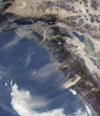
The Santa Ana winds are strong, extremely dry downslope winds that originate inland and affect coastal Southern California and northern Baja California. They originate from cool, dry high-pressure air masses in the Great Basin.

Upwelling is an oceanographic phenomenon that involves wind-driven motion of dense, cooler, and usually nutrient-rich water from deep water towards the ocean surface. It replaces the warmer and usually nutrient-depleted surface water. The nutrient-rich upwelled water stimulates the growth and reproduction of primary producers such as phytoplankton. The biomass of phytoplankton and the presence of cool water in those regions allow upwelling zones to be identified by cool sea surface temperatures (SST) and high concentrations of chlorophyll-a.

A mesocyclone is a meso-gamma mesoscale region of rotation (vortex), typically around 2 to 6 mi in diameter, most often noticed on radar within thunderstorms. In the northern hemisphere it is usually located in the right rear flank of a supercell, or often on the eastern, or leading, flank of a high-precipitation variety of supercell. The area overlaid by a mesocyclone’s circulation may be several miles (km) wide, but substantially larger than any tornado that may develop within it, and it is within mesocyclones that intense tornadoes form.

Orographic lift occurs when an air mass is forced from a low elevation to a higher elevation as it moves over rising terrain. As the air mass gains altitude it quickly cools down adiabatically, which can raise the relative humidity to 100% and create clouds and, under the right conditions, precipitation.

Deposition is the geological process in which sediments, soil and rocks are added to a landform or landmass. Wind, ice, water, and gravity transport previously weathered surface material, which, at the loss of enough kinetic energy in the fluid, is deposited, building up layers of sediment.

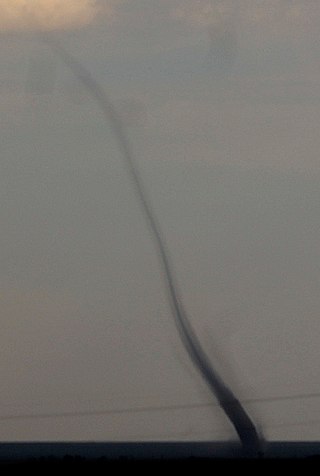
A waterspout is an intense columnar vortex that occurs over a body of water. Some are connected to a cumulus congestus cloud, some to a cumuliform cloud and some to a cumulonimbus cloud. In the common form, it is a non-supercell tornado over water having a five-part life cycle: formation of a dark spot on the water surface, spiral pattern on the water surface, formation of a spray ring, development of the visible condensation funnel, and ultimately, decay.

June Gloom is a California term for a weather pattern that results in cloudy, overcast skies with cool temperatures during the late spring and early summer. While it is most common in the month of June, it can occur in surrounding months, giving rise to other colloquialisms, such as "May Gray", "No-Sky July", and "Fogust". Low-altitude stratus clouds form over the cool water of the California Current, and spread overnight into the coastal regions of California.

A gustnado is a brief, shallow surface-based vortex which forms within the downburst emanating from a thunderstorm. The name is a portmanteau by elision of "gust front tornado", as gustnadoes form due to non-tornadic straight-line wind features in the downdraft (outflow), specifically within the gust front of strong thunderstorms. Gustnadoes tend to be noticed when the vortices loft sufficient debris or form condensation cloud to be visible although it is the wind that makes the gustnado, similarly to tornadoes. As these eddies very rarely connect from the surface to the cloud base, they are very rarely considered as tornadoes. The gustnado has little in common with tornadoes structurally or dynamically in regard to vertical development, intensity, longevity, or formative process—as classic tornadoes are associated with mesocyclones within the inflow (updraft) of the storm, not the outflow.

The California Current is a cold water Pacific Ocean current that moves southward along the western coast of North America, beginning off southern British Columbia and ending off southern Baja California Sur. It is considered an Eastern boundary current due to the influence of the North American coastline on its course. It is also one of five major coastal currents affiliated with strong upwelling zones, the others being the Humboldt Current, the Canary Current, the Benguela Current, and the Somali Current. The California Current is part of the North Pacific Gyre, a large swirling current that occupies the northern basin of the Pacific.
Landspout is a term created by atmospheric scientist Howard B. Bluestein in 1985 for a kind of tornado not associated with a mesocyclone. The Glossary of Meteorology defines a landspout as

Berg wind is the South African name for a katabatic wind: a hot dry wind blowing down the Great Escarpment from the high central plateau to the coast.
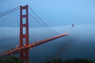
Fog is a common weather phenomenon in the San Francisco Bay Area as well as along the entire coastline of California extending south to the northwest coast of the Baja California Peninsula. The frequency of fog and low-lying stratus clouds is due to a combination of factors particular to the region that are especially prevalent in the summer. Another type of fog, tule fog, can occur during the winter. There are occasions when both types can occur simultaneously in the Bay Area. The prevalence of fog in the San Francisco Bay Area has decreased, and this trend is typically attributed to climate change.
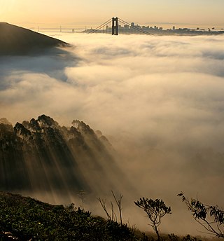
A marine layer is an air mass that develops over the surface of a large body of water, such as an ocean or large lake, in the presence of a temperature inversion. The inversion itself is usually initiated by the cooling effect of the water on the surface layer of an otherwise warm air mass.

The climate of California varies widely from hot desert to alpine tundra, depending on latitude, elevation, and proximity to the Pacific Coast. California's coastal regions, the Sierra Nevada foothills, and much of the Central Valley have a Mediterranean climate, with warmer, drier weather in summer and cooler, wetter weather in winter. The influence of the ocean generally moderates temperature extremes, creating warmer winters and substantially cooler summers in coastal areas.
The climate of San Diego, California is classified as a Mediterranean climate. The basic climate features hot, sunny, and dry summers, and cooler, wetter winters. However, San Diego is much more arid than typical Mediterranean climates, and winters are still dry compared with most other zones with this type of climate.The climate at San Diego International Airport, the location for official weather reports for San Diego, as well as the climate at most beach areas, straddles the border between BSh and BSk due to the mild winters and cool summers in these locations.
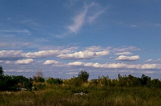
Horizontal convective rolls, also known as horizontal roll vortices or cloud streets, are long rolls of counter-rotating air that are oriented approximately parallel to the ground in the planetary boundary layer. Although horizontal convective rolls, also known as cloud streets, have been clearly seen in satellite photographs for the last 30 years, their development is poorly understood, due to a lack of observational data. From the ground, they appear as rows of cumulus or cumulus-type clouds aligned parallel to the low-level wind. Research has shown these eddies to be significant to the vertical transport of momentum, heat, moisture, and air pollutants within the boundary layer. Cloud streets are usually more or less straight; rarely, cloud streets assume paisley patterns when the wind driving the clouds encounters an obstacle. Those cloud formations are known as von Kármán vortex streets.
The following is a glossary of tornado terms. It includes scientific as well as selected informal terminology.

This glossary of meteorology is a list of terms and concepts relevant to meteorology and atmospheric science, their sub-disciplines, and related fields.

