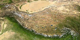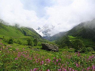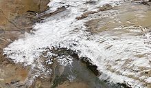
The Himalayas, or Himalaya, is a mountain range in Asia, separating the plains of the Indian subcontinent from the Tibetan Plateau. The range has some of the Earth's highest peaks, including the highest, Mount Everest; more than 100 peaks exceeding elevations of 7,200 m (23,600 ft) above sea level lie in the Himalayas.

A monsoon is traditionally a seasonal reversing wind accompanied by corresponding changes in precipitation but is now used to describe seasonal changes in atmospheric circulation and precipitation associated with annual latitudinal oscillation of the Intertropical Convergence Zone (ITCZ) between its limits to the north and south of the equator. Usually, the term monsoon is used to refer to the rainy phase of a seasonally changing pattern, although technically there is also a dry phase. The term is also sometimes used to describe locally heavy but short-term rains.

Orographic lift occurs when an air mass is forced from a low elevation to a higher elevation as it moves over rising terrain. As the air mass gains altitude it quickly cools down adiabatically, which can raise the relative humidity to 100% and create clouds and, under the right conditions, precipitation.

A rain shadow is an area of significantly reduced rainfall behind a mountainous region, on the side facing away from prevailing winds, known as its leeward side.

The climate of India consists of a wide range of weather conditions across a vast geographic scale and varied topography. Based on the Köppen system, India hosts six major climatic sub types, ranging from arid deserts in the west, alpine tundra and glaciers in the north, and humid tropical regions supporting rain forests in the southwest and the island territories. Many regions have starkly different microclimates, making it one of the most climatically diverse countries in the world. The country's meteorological department follows the international standard of four seasons with some local adjustments: winter, summer, monsoon or rainy season, and a post-monsoon period.

The 2006 North Indian Ocean cyclone season had no bounds, but cyclones tend to form between April and December, with peaks in May and November. These dates conventionally delimit the period of each year when most tropical cyclones form in the northern Indian Ocean.

The geography of South America contains many diverse regions and climates. Geographically, South America is generally considered a continent forming the southern portion of the landmass of the Americas, south and east of the Colombia–Panama border by most authorities, or south and east of the Panama Canal by some. South and North America are sometimes considered a single continent or supercontinent, while constituent regions are infrequently considered subcontinents.
Kharif crops, also known as monsoon crops or autumn crops, are domesticated plants that are cultivated and harvested in India, Pakistan and Bangladesh during the Indian subcontinent's monsoon season, which lasts from June to November depending on the area. Monsoon rains may begin as early as May in some parts of the Indian subcontinent, and crops are generally harvested from the third week of September to October. Rice, maize, and cotton are some of the major Kharif crops in India. Unlike the Rabi crops, which are grown in the winter, the kharif crops require good rainfall.

The characteristics of United States rainfall climatology differ significantly across the United States and those under United States sovereignty. Summer and early fall bring brief, but frequent thundershowers and tropical cyclones which create a wet summer and drier winter in the eastern Gulf and lower East Coast. During the winter, and spring, Pacific storm systems bring Hawaii and the western United States most of their precipitation. Low pressure systems moving up the East Coast and through the Great Lakes, bring cold season precipitation to from the Midwest to New England, as well as Great Salt Lake. The snow to liquid ratio across the contiguous United States averages 13:1, meaning 13 inches (330 mm) of snow melts down to 1 inch (25 mm) of water.
The climate of Delhi is an overlap between monsoon-influenced humid subtropical and semi-arid, with high variation between summer and winter temperatures and precipitation. Delhi's version of a humid subtropical climate is markedly different from many other humid subtropical cities such as São Paulo, Houston, and Brisbane in that the city features dust storms and wildfire haze due to its semi-arid climate.

The 2002–03 South Pacific cyclone season was the most active and longest tropical cyclone season since 1997–98, with ten tropical cyclones occurring within the South Pacific basin between 160°E and 120°W. The season started earlier than normal, with two systems developing before the official start of the season on November 1, 2002, while the final system dissipated on June 9, 2003, after the season had officially ended on April 30. During the season, tropical cyclones were officially monitored by the Regional Specialized Meteorological Centre (RSMC) in Nadi, Fiji and the Tropical Cyclone Warning Centres in Brisbane, Australia and Wellington, New Zealand. The United States Armed Forces through the Joint Typhoon Warning Center (JTWC), also monitored the basin and issued unofficial warnings for American interests. RSMC Nadi attaches a number and an F suffix to tropical disturbances that occur within the basin, while the JTWC designates significant tropical cyclones with a number and a P suffix. RSMC Nadi, TCWC Wellington and TCWC Brisbane all use the Australian Tropical Cyclone Intensity Scale and estimate windspeeds over a ten-minute period, while the JTWC estimates sustained winds over a one-minute period, which are subsequently compared to the Saffir–Simpson Hurricane Scale (SSHS).

The 2002 North Indian Ocean cyclone season was a below average season in terms of tropical cyclone formation. The season had no official bounds, but most storms formed in either May or after October. No depressions or storms formed during the monsoon season from July to September, the first such instance on record. There are two main seas in the North Indian Ocean – the Bay of Bengal to the east of the Indian subcontinent – and the Arabian Sea to the west of India. The official Regional Specialized Meteorological Centre in this basin is the India Meteorological Department (IMD), while the Joint Typhoon Warning Center (JTWC) releases unofficial advisories. An average of four to six storms form in the North Indian Ocean every season with peaks in May and November. Cyclones occurring between the meridians 45°E and 100°E are included in the season by the IMD.

The North American monsoon, variously known as the Southwest monsoon, the Mexican monsoon, the New Mexican monsoon, or the Arizona monsoon is a pattern of pronounced increase in thunderstorms and rainfall over large areas of the southwestern United States and northwestern Mexico, centered roughly on the Rio Grande Valley, and typically occurring between June and mid-September. During the monsoon, thunderstorms are fueled by daytime heating and build up during the late afternoon and early evening. Typically, these storms dissipate by late night, and the next day starts out fair, with the cycle repeating daily. The monsoon typically loses its energy by mid-September when much drier conditions are reestablished over the region. Geographically, the North American monsoon precipitation region is centered over the Sierra Madre Occidental in the Mexican states of Sinaloa, Durango, Sonora and Chihuahua.

Pakistan's climate varies from a continental type of climate in the north, a mountainous dry climate in the west (Baluchistan), a wet climate in the East (Punjab) an arid climate in the Thar Desert, to a tropical climate in the southeast, characterized by extreme variations in temperature, both seasonally and daily, because it is located on a great landmass barely north of the Tropic of Cancer.

Inflow is the flow of a fluid into a large collection of that fluid. Within meteorology, inflow normally refers to the influx of warmth and moisture from air within the Earth's atmosphere into storm systems. Extratropical cyclones are fed by inflow focused along their cold front and warm fronts. Tropical cyclones require a large inflow of warmth and moisture from warm oceans in order to develop significantly, mainly within the lowest 1 kilometre (0.62 mi) of the atmosphere. Once the flow of warm and moist air is cut off from thunderstorms and their associated tornadoes, normally by the thunderstorm's own rain-cooled outflow boundary, the storms begin to dissipate. Rear inflow jets behind squall lines act to erode the broad rain shield behind the squall line, and accelerate its forward motion.

Earth rainfall climatology Is the study of rainfall, a sub-field of meteorology. Formally, a wider study includes water falling as ice crystals, i.e. hail, sleet, snow. The aim of rainfall climatology is to measure, understand and predict rain distribution across different regions of planet Earth, a factor of air pressure, humidity, topography, cloud type and raindrop size, via direct measurement and remote sensing data acquisition. Current technologies accurately predict rainfall 3–4 days in advance using numerical weather prediction. Geostationary orbiting satellites gather IR and visual wavelength data to measure realtime localised rainfall by estimating cloud albedo, water content, and the corresponding probability of rain.

The climate of Asia is dry across its southwestern region, with dry across much of the interior. Some of the largest daily temperature ranges on Earth occur in the western part of Asia. The monsoon circulation dominates across the southern and eastern regions, due to the Himalayas forcing the formation of a thermal low which draws in moisture during the summer. The southwestern region of the continent experiences low relief as a result of the subtropical high pressure belt; they are hot in summer, warm to cool in winter, and may snow at higher altitudes. Siberia is one of the coldest places in the Northern Hemisphere, and can act as a source of arctic air mass for North America. The most active place on Earth for tropical cyclone activity lies northeast of the Philippines and south of Japan, and the phase of the El Nino-Southern Oscillation modulates where in Asia landfall is more likely to occur. Many parts of Asia are being impacted by climate change.

The Monsoon of South Asia is among several geographically distributed global monsoons. It affects the Indian subcontinent, where it is one of the oldest and most anticipated weather phenomena and an economically important pattern every year from June through September, but it is only partly understood and notoriously difficult to predict. Several theories have been proposed to explain the origin, process, strength, variability, distribution, and general vagaries of the monsoon, but understanding and predictability are still evolving.
On 23 July 2001, Islamabad experienced a record breaking 620 millimetres (24 in) of rainfall, which was the 24 hours heaviest rainfall in Pakistan during the past 100 years. Continuous downpour lasted for about 10 hours from 0600 to 1600 PST in Islamabad and Rawalpindi, caused the worst ever Flash flood in the local stream called Nulla Lai and its tributaries of Rawalpindi, which not only flood the low-lying areas of the twin cities but swept away the banks of the stream and buildings built in the encroachments. Islamabad's twin city, Rawalpindi experienced 335 millimetres (13.2 in) of rain during this event.


