Cyclogenesis

Last updated
This collage of GOES 13 satellite images shows the development of a nor'easter over two days. StormCollage-GOES-13.jpg
This collage of GOES 13 satellite images shows the development of a nor'easter over two days.

Cyclogenesis is the development or strengthening of cyclonic circulation in the atmosphere (a low-pressure area). [1] Cyclogenesis is an umbrella term for at least three different processes, all of which result in the development of some sort of cyclone, and at any size from the microscale to the synoptic scale.

Contents

The process in which an extratropical cyclone undergoes a rapid drop in atmospheric pressure (24 millibars or more) in a 24-hour period is referred to as explosive cyclogenesis, and is usually present during the formation of a nor'easter. [2] Similarly, a tropical cyclone can undergo rapid intensification.

The anticyclonic equivalent, the process of formation of high-pressure areas, is anticyclogenesis. [3] The opposite of cyclogenesis is cyclolysis.

Meteorological scales

There are four main scales, or sizes of systems, dealt with in meteorology: the macroscale, the synoptic scale, the mesoscale, and the microscale. [4] The macroscale deals with systems with global size, such as the Madden–Julian oscillation. Synoptic scale systems cover a portion of a continent, such as extratropical cyclones, with dimensions of 1,000–2,500 km (620–1,550 mi) across. [5] The mesoscale is the next smaller scale, and often is divided into two ranges: meso-alpha phenomena range from 200–2,000 km (120–1,240 mi) across (the realm of the tropical cyclone), while meso-beta phenomena range from 20–200 km (12–124 mi) across (the scale of the mesocyclone). The microscale is the smallest of the meteorological scales, with a size under two kilometers (1.2 miles) (the scale of tornadoes and waterspouts). [6] These horizontal dimensions are not rigid divisions but instead reflect typical sizes of phenomena having certain dynamic characteristics. For example, a system does not necessarily transition from meso-alpha to synoptic scale when its horizontal extent grows from 2,000 to 2,001 km (1,242.7 to 1,243.4 mi).

Extratropical cyclones

The initial frontal wave (or low-pressure area) forms at the location of the red dot on the image. It is usually perpendicular (at a right angle) to the leaf-like cloud formation (baroclinic leaf) seen on satellite during the early stage of cyclogenesis. The location of the axis of the upper level jet stream is in light blue. Baroclinicleafphasecyclogenesiscropped.gif
The initial frontal wave (or low-pressure area) forms at the location of the red dot on the image. It is usually perpendicular (at a right angle) to the leaf-like cloud formation (baroclinic leaf) seen on satellite during the early stage of cyclogenesis. The location of the axis of the upper level jet stream is in light blue.

Norwegian cyclone model

An upper-level jet streak. DIV areas are regions of divergence aloft, which will lead to surface convergence and aid cyclogenesis. Jetstreak.png
An upper-level jet streak. DIV areas are regions of divergence aloft, which will lead to surface convergence and aid cyclogenesis.

The Norwegian cyclone model is an idealized formation model of cold-core cyclonic storms developed by Norwegian meteorologists during the First World War. [7] The main concept behind this model, relating to cyclogenesis, is that cyclones progress through a predictable evolution as they move up a frontal boundary, with the most mature cyclone near the northeast end of the front and the least mature near the tail end of the front. [8]

Precursors for development

A preexisting frontal boundary, as defined in surface weather analysis, is required for the development of a mid-latitude cyclone. The cyclonic flow begins around a disturbed section of the stationary front due to an upper level disturbance, such as a short wave or an upper-level trough, [9] [10] near a favorable quadrant of the upper-level jet. [11] However, enhanced along-frontal stretching rates in the lower troposphere can suppress the growth of extratropical cyclones. [12] [13]

Vertical motion affecting development

Cyclogenesis can only occur when temperature decreases polewards (to the north, in the northern hemisphere), and pressure perturbation lines tilt westward with height. Cyclogenesis is most likely to occur in regions of cyclonic vorticity advection, downstream of a strong westerly jet. [14] The combination of vorticity advection and thermal advection created by the temperature gradient and a low pressure center cause upward motion around the low. [lower-alpha 1] If the temperature gradient is strong enough, temperature advection will increase, driving more vertical motion. This increases the overall strength of the system. Shearwise updrafts [lower-alpha 2] are the most important factor in determining cyclonic growth and strength. [16]

Modes of development

A surface low can have a variety of causes for forming. Topography can force a surface low to form when an existing baroclinic wave moves over a mountain barrier; this is known as "lee cyclogenesis" since the low forms on the leeward side of the mountains. [17] [18] Mesoscale convective systems can spawn surface lows which are initially warm core. [19] The disturbance can grow into a wave-like formation along the front and the low will be positioned at the crest. Around the low, flow will become cyclonic, by definition. This rotational flow will push polar air equator-ward west of the low via its trailing cold front, and warmer air will push poleward low via the warm front. Usually the cold front will move at a quicker pace than the warm front and "catch up" with it due to the slow erosion of higher density airmass located out ahead of the cyclone and the higher density airmass sweeping in behind the cyclone, usually resulting in a narrowing warm sector. [20] At this point an occluded front forms where the warm air mass is pushed upwards into a trough of warm air aloft, which is also known as a trowal (a trough of warm air aloft). [21] All developing low-pressure areas share one important aspect, that of upward vertical motion within the troposphere. Such upward motions decrease the mass of local atmospheric columns of air, which lower surface pressure. [22]

Maturity

Maturity is after the time of occlusion when the storm has completed strengthening and the cyclonic flow is at its most intense. [23] Thereafter, the strength of the storm diminishes as the cyclone couples with the upper-level trough or upper-level low, becoming increasingly cold core. The spin-down of cyclones, also known as cyclolysis, can be understood from an energetics perspective. As occlusion occurs and the warm air mass is pushed upwards over a cold air airmass, the atmosphere becomes increasingly stable and the centre of gravity of the system lowers. [24] As the occlusion process extends further down the warm front and away from the central low, more and more of the available potential energy of the system is exhausted. This potential energy sink creates a kinetic energy source which injects a final burst of energy into the storm's motions. After this process occurs, the growth period of the cyclone, or cyclogenesis, ends, and the low begins to spin down (fill) as more air is converging into the bottom of the cyclone than is being removed out the top since upper-level divergence has decreased.

Occasionally, cyclogenesis will re-occur with occluded cyclones. When this happens a new low center will form on the triple-point (the point where the cold front, warm front, and occluded front meet). During triple-point cyclogenesis, the occluded parent low will fill as the secondary low deepens into the main weathermaker.

Tropical cyclones

Tropical cyclones exist within a mesoscale alpha domain. As opposed to mid-latitude cyclogenesis, tropical cyclogenesis is driven by strong convection organised into a central core with no baroclinic zones, or fronts, extending through their center. Although the formation of tropical cyclones is the topic of extensive ongoing research and is still not fully understood, there are six main requirements for tropical cyclogenesis: sea surface temperatures that are warm enough, atmospheric instability, high humidity in lower to middle levels of the troposphere, enough Coriolis force to develop a low pressure center, a pre-existing low level focus or disturbance, and low vertical wind shear. These warm core cyclones tend to form over the oceans between 10 and 30 degrees of the equator. [25] [26]

Mesocyclones

Mesocyclones range in size from mesoscale beta to microscale. The term mesocyclone is usually reserved for mid-level rotations within severe thunderstorms, [27] and are warm core cyclones driven by latent heat of its associated thunderstorm activity.

Tornadoes form in the warm sector of extratropical cyclones where a strong upper-level jet stream exists. [28] Mesocyclones are believed to form when strong changes of wind speed and/or direction with height ("wind shear") sets parts of the lower part of the atmosphere spinning in invisible tube-like rolls. The convective updraft of a thunderstorm is then thought to draw up this spinning air, tilting the rolls' orientation upward (from parallel to the ground to perpendicular) and causing the entire updraft to rotate as a vertical column.

As the updraft rotates, it may form what is known as a wall cloud. The wall cloud is a spinning layer of clouds descending from the mesocyclone. The wall cloud tends to form closer to the center of the mesocyclone. The wall clouds do not necessarily need a mesocyclone to form and do not always rotate. As the wall cloud descends, a funnel-shaped cloud may form at its center. This is the first stage of tornado formation. [29] The presence of a mesocyclone is believed to be a key factor in the formation of the strong tornadoes associated with severe thunderstorms.

Tornadoes

Tornadoes exist on the microscale or low end of the mesoscale gamma domain. The cycle begins when a strong thunderstorm develops a rotating mesocyclone a few miles up in the atmosphere, becoming a supercell. As rainfall in the storm increases, it drags with it an area of quickly descending air known as the rear flank downdraft (RFD). This downdraft accelerates as it approaches the ground, and drags the rotating mesocyclone towards the ground with it. [30]

As the mesocyclone approaches the ground, a visible condensation funnel appears to descend from the base of the storm, often from a rotating wall cloud. As the funnel descends, the RFD also reaches the ground, creating a gust front that can cause damage a good distance from the tornado. Usually, the funnel cloud begins causing damage on the ground (becoming a tornado) within minutes of the RFD reaching the ground. [31]

Waterspouts

Waterspouts exist on the microscale. While some waterspouts are strong (tornadic) like their land-based counterparts, most are much weaker and caused by different atmospheric dynamics. They normally develop in moisture-laden environments with little vertical wind shear along lines of convergence, such as land breezes, lines of frictional convergence from nearby landmasses, or surface troughs. [32] Their parent cloud can be as innocuous as a moderate cumulus, or as significant as a thunderstorm. Waterspouts normally develop as their parent clouds are in the process of development, and it is theorized that they spin up as they move up the surface boundary from the horizontal wind shear near the surface, and then stretch upwards to the cloud once the low level shear vortex aligns with a developing cumulus or thunderstorm. Weak tornadoes, known as landspouts, across eastern Colorado have been witnessed to develop in a similar manner. [33] An outbreak occurred in the Great Lakes in late September and early October 2003 along a lake effect band. September is the peak month of landspout and waterspout occurrence around Florida and for waterspout occurrence around the Great Lakes. [33] [34]

Cyclogenesis is the opposite of cyclolysis, which concerns the weakening of surface cyclones. The term has an anticyclonic (high-pressure system) equivalent—Anticyclogenesis, which deals with the formation of surface high-pressure systems. [3]

See also

Notes

  1. Using Q-Vectors, we can determine the direction of vertical motion. [15] Southerly flow and warm advection induce an upward motion while northerly flow and cold advection induce a downward motion in the northern hemisphere. These vertical motions cause the low to be stretched and vorticity around the system is increased. This increase in system vorticity can be shown through the QG vorticity equation (a partial differential equation):
    ,
    where is the relative vorticity, is the Coriolis parameter under the beta-plane approximation, is the partial derivative of vertical motion with respect to height, and is a material derivative. [15] With planetary vorticity term staying constant, we can deduce that with an increase in stretching, vorticity must increase as well. The vertical motion also increases temperature advection, by the equation , where is the geostrophic meridional wind and represents geopotential. [15]
  2. Shearwise updrafts are upward motions in a system of vertical movements which are changing in direction.

Related Research Articles

<span class="mw-page-title-main">Tornado</span> Violently rotating column of air in contact with both the Earths surface and a cumulonimbus cloud

A tornado is a violently rotating column of air that is in contact with both the surface of the Earth and a cumulonimbus cloud or, in rare cases, the base of a cumulus cloud. It is often referred to as a twister, whirlwind or cyclone, although the word cyclone is used in meteorology to name a weather system with a low-pressure area in the center around which, from an observer looking down toward the surface of the Earth, winds blow counterclockwise in the Northern Hemisphere and clockwise in the Southern. Tornadoes come in many shapes and sizes, and they are often visible in the form of a condensation funnel originating from the base of a cumulonimbus cloud, with a cloud of rotating debris and dust beneath it. Most tornadoes have wind speeds less than 180 kilometers per hour, are about 80 meters across, and travel several kilometers before dissipating. The most extreme tornadoes can attain wind speeds of more than 480 kilometers per hour (300 mph), are more than 3 kilometers (2 mi) in diameter, and stay on the ground for more than 100 km (62 mi).

<span class="mw-page-title-main">Cyclone</span> Large scale air mass that rotates around a strong center of low pressure

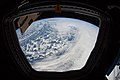
In meteorology, a cyclone is a large air mass that rotates around a strong center of low atmospheric pressure, counterclockwise in the Northern Hemisphere and clockwise in the Southern Hemisphere as viewed from above. Cyclones are characterized by inward-spiraling winds that rotate about a zone of low pressure. The largest low-pressure systems are polar vortices and extratropical cyclones of the largest scale. Warm-core cyclones such as tropical cyclones and subtropical cyclones also lie within the synoptic scale. Mesocyclones, tornadoes, and dust devils lie within the smaller mesoscale.

<span class="mw-page-title-main">Thunderstorm</span> Type of weather with lightning and thunder

A thunderstorm, also known as an electrical storm or a lightning storm, is a storm characterized by the presence of lightning and its acoustic effect on the Earth's atmosphere, known as thunder. Relatively weak thunderstorms are sometimes called thundershowers. Thunderstorms occur in a type of cloud known as a cumulonimbus. They are usually accompanied by strong winds and often produce heavy rain and sometimes snow, sleet, or hail, but some thunderstorms produce little precipitation or no precipitation at all. Thunderstorms may line up in a series or become a rainband, known as a squall line. Strong or severe thunderstorms include some of the most dangerous weather phenomena, including large hail, strong winds, and tornadoes. Some of the most persistent severe thunderstorms, known as supercells, rotate as do cyclones. While most thunderstorms move with the mean wind flow through the layer of the troposphere that they occupy, vertical wind shear sometimes causes a deviation in their course at a right angle to the wind shear direction.

<span class="mw-page-title-main">Mesocyclone</span> Region of rotation within a powerful thunderstorm

A mesocyclone is a meso-gamma mesoscale region of rotation (vortex), typically around 2 to 6 mi in diameter, most often noticed on radar within thunderstorms. In the northern hemisphere it is usually located in the right rear flank of a supercell, or often on the eastern, or leading, flank of a high-precipitation variety of supercell. The area overlaid by a mesocyclone’s circulation may be several miles (km) wide, but substantially larger than any tornado that may develop within it, and it is within mesocyclones that intense tornadoes form.

<span class="mw-page-title-main">Squall</span> Short, sharp increase in wind speed

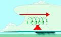
A squall is a sudden, sharp increase in wind speed lasting minutes, as opposed to a wind gust, which lasts for only seconds. They are usually associated with active weather, such as rain showers, thunderstorms, or heavy snow. Squalls refer to the increase of the sustained winds over that time interval, as there may be higher gusts during a squall event. They usually occur in a region of strong sinking air or cooling in the mid-atmosphere. These force strong localized upward motions at the leading edge of the region of cooling, which then enhances local downward motions just in its wake.

<span class="mw-page-title-main">Squall line</span> Line of thunderstorms along or ahead of a cold front

A squall line, or more accurately a quasi-linear convective system (QLCS), is a line of thunderstorms, often forming along or ahead of a cold front. In the early 20th century, the term was used as a synonym for cold front. Linear thunderstorm structures often contain heavy precipitation, hail, frequent lightning, strong straight-line winds, and occasionally tornadoes or waterspouts. Particularly strong straight-line winds can occur where the linear structure forms into the shape of a bow echo. Tornadoes can occur along waves within a line echo wave pattern (LEWP), where mesoscale low-pressure areas are present. Some bow echoes can grow to become derechos as they move swiftly across a large area. On the back edge of the rainband associated with mature squall lines, a wake low can be present, on very rare occasions associated with a heat burst.

<span class="mw-page-title-main">Low-pressure area</span> Area with air pressures lower than adjacent areas

In meteorology, a low-pressure area, low area or low is a region where the atmospheric pressure is lower than that of surrounding locations. Low-pressure areas are commonly associated with inclement weather, while high-pressure areas are associated with lighter winds and clear skies. Winds circle anti-clockwise around lows in the northern hemisphere, and clockwise in the southern hemisphere, due to opposing Coriolis forces. Low-pressure systems form under areas of wind divergence that occur in the upper levels of the atmosphere (aloft). The formation process of a low-pressure area is known as cyclogenesis. In meteorology, atmospheric divergence aloft occurs in two kinds of places:

<span class="mw-page-title-main">Funnel cloud</span> Funnel-shaped cloud extending from a cloud base but doesnt touch the ground

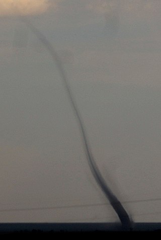
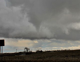
A funnel cloud is a funnel-shaped cloud of condensed water droplets, associated with a rotating column of wind and extending from the base of a cloud but not reaching the ground or a water surface. A funnel cloud is usually visible as a cone-shaped or needle like protuberance from the main cloud base. Funnel clouds form most frequently in association with supercell thunderstorms, and are often, but not always, a visual precursor to tornadoes. Funnel clouds are visual phenomena, these are not the vortex of wind itself.

<span class="mw-page-title-main">Gustnado</span> Ground vortex formed from a downburst of a thunderstorm

A gustnado is a brief, shallow surface-based vortex which forms within the downburst emanating from a thunderstorm. The name is a portmanteau by elision of "gust front tornado", as gustnadoes form due to non-tornadic straight-line wind features in the downdraft (outflow), specifically within the gust front of strong thunderstorms. Gustnadoes tend to be noticed when the vortices loft sufficient debris or form condensation cloud to be visible although it is the wind that makes the gustnado, similarly to tornadoes. As these eddies very rarely connect from the surface to the cloud base, they are very rarely considered as tornadoes. The gustnado has little in common with tornadoes structurally or dynamically in regard to vertical development, intensity, longevity, or formative process—as classic tornadoes are associated with mesocyclones within the inflow (updraft) of the storm, not the outflow.

<span class="mw-page-title-main">Outflow boundary</span> Mesoscale boundary separating outflow from the surrounding air

An outflow boundary, also known as a gust front, is a storm-scale or mesoscale boundary separating thunderstorm-cooled air (outflow) from the surrounding air; similar in effect to a cold front, with passage marked by a wind shift and usually a drop in temperature and a related pressure jump. Outflow boundaries can persist for 24 hours or more after the thunderstorms that generated them dissipate, and can travel hundreds of kilometers from their area of origin. New thunderstorms often develop along outflow boundaries, especially near the point of intersection with another boundary. Outflow boundaries can be seen either as fine lines on weather radar imagery or else as arcs of low clouds on weather satellite imagery. From the ground, outflow boundaries can be co-located with the appearance of roll clouds and shelf clouds.

This is a list of meteorology topics. The terms relate to meteorology, the interdisciplinary scientific study of the atmosphere that focuses on weather processes and forecasting.

<span class="mw-page-title-main">Mesoscale convective system</span> Complex of thunderstorms organized on a larger scale

A mesoscale convective system (MCS) is a complex of thunderstorms that becomes organized on a scale larger than the individual thunderstorms but smaller than extratropical cyclones, and normally persists for several hours or more. A mesoscale convective system's overall cloud and precipitation pattern may be round or linear in shape, and include weather systems such as tropical cyclones, squall lines, lake-effect snow events, polar lows, and mesoscale convective complexes (MCCs), and generally forms near weather fronts. The type that forms during the warm season over land has been noted across North and South America, Europe, and Asia, with a maximum in activity noted during the late afternoon and evening hours.

<span class="mw-page-title-main">Landspout</span> Tornado not originating from a mesocyclone

Landspout is a term created by atmospheric scientist Howard B. Bluestein in 1985 for a tornado not associated with a mesocyclone. The Glossary of Meteorology defines a landspout as

<span class="mw-page-title-main">Tornadogenesis</span> Process by which a tornado forms

Tornadogenesis is the process by which a tornado forms. There are many types of tornadoes and these vary in methods of formation. Despite ongoing scientific study and high-profile research projects such as VORTEX, tornadogenesis is a volatile process and the intricacies of many of the mechanisms of tornado formation are still poorly understood.

<span class="mw-page-title-main">Rear flank downdraft</span> Type of region

The rear flank downdraft (RFD) is a region of dry air wrapping around the back of a mesocyclone in a supercell thunderstorm. These areas of descending air are thought to be essential in the production of many supercellular tornadoes. Large hail within the rear flank downdraft often shows up brightly as a hook on weather radar images, producing the characteristic hook echo, which often indicates the presence of a tornado.

<span class="mw-page-title-main">Inflow (meteorology)</span> Meteorological term for flow of a fluid into a large collection of itself

Inflow is the flow of a fluid into a large collection of that fluid. Within meteorology, inflow normally refers to the influx of warmth and moisture from air within the Earth's atmosphere into storm systems. Extratropical cyclones are fed by inflow focused along their cold front and warm fronts. Tropical cyclones require a large inflow of warmth and moisture from warm oceans in order to develop significantly, mainly within the lowest 1 kilometre (0.62 mi) of the atmosphere. Once the flow of warm and moist air is cut off from thunderstorms and their associated tornadoes, normally by the thunderstorm's own rain-cooled outflow boundary, the storms begin to dissipate. Rear inflow jets behind squall lines act to erode the broad rain shield behind the squall line, and accelerate its forward motion.

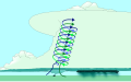
A mesovortex is a small-scale rotational feature found in a convective storm, such as a quasi-linear convective system, a supercell, or the eyewall of a tropical cyclone. Mesovortices range in diameter from tens of miles to a mile or less and can be immensely intense.

The following is a glossary of tornado terms. It includes scientific as well as selected informal terminology.

<span class="mw-page-title-main">Glossary of meteorology</span> List of definitions of terms and concepts commonly used in meteorology

This glossary of meteorology is a list of terms and concepts relevant to meteorology and atmospheric science, their sub-disciplines, and related fields.

<span class="mw-page-title-main">Cyclolysis</span> The process of dissipation of a cyclone

Cyclolysis is a process in which a cyclonic circulation weakens and deteriorates. Cyclolysis is the opposite of cyclogenesis.

References

  1. Arctic Climatology and Meteorology (2006). "Cyclogenesis". National Snow and Ice Data Center. Archived from the original on 2006-08-30. Retrieved 2006-12-04.
  2. Sanders, F.; J. R. Gyakum (1980-06-12). "Synoptic-dynamic climatology of the "Bomb"" (PDF). Massachusetts Institute of Technology, Cambridge. Archived from the original (PDF) on 2016-03-05. Retrieved 2012-01-21.
  3. 1 2 "Cyclogenesis". Glossary of Meteorology. American Meteorological Society. 26 January 2012. Retrieved 2016-07-23.
  4. Mesoscale Dynamics and Modeling Laboratory (2006-09-08). "Part I: Introduction to Mesoscale Dynamics". Archived from the original on 2006-09-08. Retrieved 2006-12-04.
  5. Arctic Climatology and Meteorology (2006). "Synoptic Scale". Archived from the original on 2006-08-27. Retrieved 2006-10-25.
  6. University Corporation for Atmospheric Research. Definition of Mesoscale. Retrieved on 2006-10-25.
  7. JetStream (2009-09-01). "Norwegian Cyclone Model". National Weather Service Southern Region Headquarters. Archived from the original on 2016-01-04. Retrieved 2009-10-26.
  8. "The Norwegian Cyclone Model" (PDF). University of Oklahoma School of Meteorology. Archived from the original (PDF) on September 1, 2006.
  9. Glossary of Meteorology (June 2000). "Definition of Short Wave". American Meteorological Society. Archived from the original on 2009-06-09. Retrieved 2009-10-26.
  10. Glossary of Meteorology (June 2000). "Definition of Upper-Level Trough". American Meteorological Society. Archived from the original on 2009-06-09. Retrieved 2009-10-26.
  11. Carlyle H. Wash, Stacey H. Heikkinen, Chi-Sann Liou, and Wendell A. Nuss. A Rapid Cyclogenesis Event during GALE IOP 9. Retrieved on 2008-06-28.
  12. Schemm, S.; Sprenger, M. (2015). "Frontal-wave cyclogenesis in the North Atlantic –a climatological characterisation". Quarterly Journal of the Royal Meteorological Society. 141 (693): 2989–3005. Bibcode:2015QJRMS.141.2989S. doi: 10.1002/qj.2584 . hdl:1956/11634.
  13. Bishop, Craig H. and Thorpe, Alan J. (1994). "Frontal Wave Stability during Moist Deformation Frontogenesis. Part II: The Suppression of Nonlinear Wave Development". Journal of the Atmospheric Sciences. 51 (6): 874–888. Bibcode:1994JAtS...51..874B. doi: 10.1175/1520-0469(1994)051<0874:FWSDMD>2.0.CO;2 .{{cite journal}}: CS1 maint: multiple names: authors list (link)
  14. Wallace, John M.; Peter V. Hobbs (2006). Atmospheric Science An Introductory Survey. University of Washington, Seattle.
  15. 1 2 3 Holton, James R. (2004). An Introduction to Dynamic Meteorology. University of Washington, Seattle.
  16. Martin, Jonathon E. (2006-10-10). "American Meteorological Society". Monthly Weather Review. 135 (7): 2803–2809. CiteSeerX   10.1.1.529.5005 . doi:10.1175/MWR3416.1.
  17. "Flow Interaction With Topography". COMET Program. Archived from the original on 8 May 2002.
  18. "Lee cyclogenesis". Glossary of Meteorology. American Meteorological Society. 25 April 2012.
  19. Raymond D. Menard1, and J.M. Fritsch A Mesoscale Convective Complex-Generated Inertially Stable Warm Core Vortex
  20. Chu, Rachel (2006). "Density of Air". The Physics Factbook.
  21. St. Louis University What is a trowal? Archived September 16, 2006, at the Wayback Machine
  22. Joel Norris (2005-03-19). "QG Notes". University of California, San Diego. Retrieved 2009-10-26.
  23. Joan Von Ahn; Joe Sienkiewicz; Greggory McFadden (April 2005). "Hurricane Force Extratropical Cyclones Observed Using QuikSCAT Near Real Time Winds". Mariners Weather Log. 49 (1). Retrieved 2009-10-26.
  24. Steve W. Woodruff (2008-06-12). "About Atmospheric Stability". Pierce College. Archived from the original on June 12, 2008. Retrieved 2009-10-26.
  25. Chris Landsea (2009-02-08). "Subject: A15) How do tropical cyclones form?". National Hurricane Center. Archived from the original on 2009-08-27. Retrieved 2009-10-26.
  26. Environment Canada (2003-09-18). "Tropical Cyclone Formation". Archived from the original on 2006-09-27. Retrieved 2009-10-26.
  27. Thomas Allen Jones (2007-03-11). "Mesocyclone Formation and Maintenance: A Review of Conceptual Models". Archived from the original on March 11, 2007. Retrieved 2009-10-26.
  28. University Corporation for Atmospheric Research (September 2000). "How a Tornado Forms". Archived from the original on 2007-10-17. Retrieved 2009-10-26.
  29. Michael Branick (2008-06-11). "A Comprehensive Glossary of Weather". Geographic.org. Retrieved 2009-10-26.
  30. Timothy P. Marshall; Erik N. Rasmussen (January 1982). "The Mesoscale Evolution of the Warren, Oklahoma Tornadoes". 12th Conference on Severe Local Storms. Archived from the original on 2009-09-21. Retrieved 2009-10-26.
  31. Storm Prediction Center. The Online Tornado FAQ. Archived 2006-09-29 at the Wayback Machine Retrieved on 2006-10-25.
  32. Barry K. Choy and Scott M. Spratt. A WSR-88D Approach to Waterspout Forecasting. Archived October 5, 2006, at the Wayback Machine Retrieved on 2006-12-04.
  33. 1 2 Barry K. Choy and Scott M. Spratt. Using the WSR-88D to Predict East Central Florida Waterspouts. Archived June 17, 2008, at the Wayback Machine Retrieved on 2006-10-25.
  34. "The Great Waterspout Outbreak of 2003". Mariners Weather Log. 48 (3). December 2004. Retrieved 2006-10-25.