
The 1966 Atlantic hurricane season saw the Weather Bureau office in Miami, Florida, be designated as the National Hurricane Center (NHC) and assume responsibility of tropical cyclone forecasting in the basin. The season officially began on June 1, and lasted until November 30. These dates conventionally delimit the period of each year when most tropical cyclones form in the Atlantic basin. It was an above-average season in terms of tropical storms, with a total of 15. The first system, Hurricane Alma, developed over eastern Nicaragua on June 4 and became a rare major hurricane in the month of June. Alma brought severe flooding to Honduras and later to Cuba, but caused relatively minor impact in the Southeastern United States. Alma resulted in 90 deaths and about $210 million (1966 USD) in damage.

The 1957 Atlantic hurricane season featured one of the longest-travelling tropical cyclones in the Atlantic basin, Hurricane Carrie. Nevertheless, the season was generally inactive, with eight tropical storms – two of which went unnamed – and three hurricanes, two of which intensified further to attain major hurricane intensity. The season officially began on June 15 and ended on November 15, though the year's first tropical cyclone developed prior to the start of the season on June 8. The final storm dissipated on October 27, well before the official end of the season. The strongest hurricane of the year was Carrie, which reached the equivalent of a Category 4 hurricane on the Saffir–Simpson hurricane scale on two separate occasions in the open Atlantic; Carrie later caused the sinking of the German ship Pamir southwest of the Azores, resulting in 80 deaths.

The 1940 Atlantic hurricane season was a generally average period of tropical cyclogenesis in 1940. Though the season had no official bounds, most tropical cyclone activity occurred during August and September. Throughout the year, fourteen tropical cyclones formed, of which nine reached tropical storm intensity; six were hurricanes. None of the hurricanes reached major hurricane intensity. Tropical cyclones that did not approach populated areas or shipping lanes, especially if they were relatively weak and of short duration, may have remained undetected. Because technologies such as satellite monitoring were not available until the 1960s, historical data on tropical cyclones from this period are often not reliable. As a result of a reanalysis project which analyzed the season in 2012, an additional hurricane was added to HURDAT. The year's first tropical storm formed on May 19 off the northern coast of Hispaniola. At the time, this was a rare occurrence, as only four other tropical disturbances were known to have formed prior during this period; since then, reanalysis of previous seasons has concluded that there were more than four tropical cyclones in May before 1940. The season's final system was a tropical disturbance situated in the Greater Antilles, which dissipated on November 8.

The 1929 Atlantic hurricane season was a near average season in terms of accumulated cyclone energy, but is among the least active Atlantic hurricane seasons on record in terms of storms forming, with only five tropical cyclones forming. Three of them intensified into a hurricane, with one strengthening further into a major hurricane. The first tropical cyclone of the season developed in the Gulf of Mexico on June 27. Becoming a hurricane on June 28, the storm struck Texas, bringing strong winds to a large area. Three fatalities were reported, while damage was conservatively estimated at $675,000 (1929 USD).

The 1912 Atlantic hurricane season was an average hurricane season that featured the first recorded November major hurricane. There were eleven tropical cyclones, seven of which became tropical storms; four of those strengthened into hurricanes, and one reached major hurricane intensity. The season's first cyclone developed on April 4, while the final dissipated on November 21. The season's most intense and most devastating tropical cyclone was the final storm, known as the Jamaica hurricane. It produced heavy rainfall on Jamaica, leading to at least 100 fatalities and about $1.5 million (1912 USD) in damage. The storm was also blamed for five deaths in Cuba.

The 1900 Atlantic hurricane season featured the Galveston hurricane, the deadliest natural disaster in the history of the United States. A total of 10 tropical cyclones formed, seven of which intensified into a tropical storm. Three of those made landfall in the United States. The first system was initially observed over the central Atlantic Ocean on January 17, while the final storm transitioned into an extratropical cyclone on October 28. These dates fall within the period with the most tropical cyclone activity in the Atlantic. Every storm of the season except the seventh system existed simultaneously with another tropical cyclone.
The 1970 Pacific typhoon season has no official bounds; it ran year-round in 1970, but most tropical cyclones tend to form in the northwestern Pacific Ocean between June and December. These dates conventionally delimit the period of each year when most tropical cyclones form in the northwestern Pacific Ocean.

The 1975 Pacific typhoon season was one of the deadliest tropical cyclone seasons on record, with nearly 229,000 fatalities occurring during the season. It had no official bounds; it ran year-round in 1975, but most tropical cyclones tend to form in the northwestern Pacific Ocean between June and December. These dates conventionally delimit the period of each year when most tropical cyclones form in the northwestern Pacific Ocean.

The 1971 Pacific typhoon season was an extremely active season that featured the second highest typhoon count on record. It has no official bounds; it ran year-round in 1971, but most tropical cyclones tend to form in the northwestern Pacific Ocean between June and December. These dates conventionally delimit the period of each year when most tropical cyclones form in the northwestern Pacific Ocean.

The 1960 Pacific typhoon season had no official bounds; it ran year-round in 1960, but most tropical cyclones tend to form in the northwestern Pacific Ocean between June and December. These dates conventionally delimit the period of each year when most tropical cyclones form in the northwestern Pacific Ocean.
The 1958 Pacific typhoon season was an event in the annual cycle of tropical cyclone formation. The season had no official bounds, but tropical cyclones in the Western Pacific Ocean normally develop between May and October. The season was below average in storms, with only twenty-three forming. However, all but two of those storms developed into typhoons, resulting in a well above-average number of typhoons, and a very high ACE figure of 445.8 units. In addition, there were also nine tropical storms tracked only by the JMA. The season began very early, with a very rare super typhoon in January, Typhoon Ophelia, and ended in early December with Typhoon Olga. It also featured Typhoon Ida, the strongest storm ever recorded at that time.

The 1963 Pacific typhoon season has no official bounds; it ran year-round in 1963, but most tropical cyclones tend to form in the northwestern Pacific Ocean between June and December. These dates conventionally delimit the period of each year when most tropical cyclones form in the northwestern Pacific Ocean.

Extratropical cyclones, sometimes called mid-latitude cyclones or wave cyclones, are low-pressure areas which, along with the anticyclones of high-pressure areas, drive the weather over much of the Earth. Extratropical cyclones are capable of producing anything from cloudiness and mild showers to severe hail, thunderstorms, blizzards, and tornadoes. These types of cyclones are defined as large scale (synoptic) low pressure weather systems that occur in the middle latitudes of the Earth. In contrast with tropical cyclones, extratropical cyclones produce rapid changes in temperature and dew point along broad lines, called weather fronts, about the center of the cyclone.
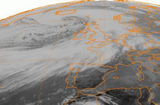
The Braer Storm was the most intense extratropical cyclone ever recorded over the northern Atlantic Ocean. Developing as a weak frontal wave on 8 January 1993, the system moved rapidly northeast. The combination of the absorption of a second low-pressure area to its southeast, a stronger than normal sea surface temperature differential along its path, and the presence of a strong jet stream aloft led to a rapid strengthening of the storm, with its central pressure falling to an estimated 914 hPa on 10 January. Its strength was well predicted by forecasters in the United Kingdom, and warnings were issued before the low initially developed.

The 2012 Atlantic hurricane season was the final year in a string of three consecutive very active seasons since 2010, with 19 tropical storms. The 2012 season was also a costly one in terms of property damage, mostly due to Hurricane Sandy. The season officially began on June 1 and ended on November 30, dates that conventionally delimit the period during each year in which most tropical cyclones form in the Atlantic Ocean. However, Alberto, the first named system of the year, developed on May 19 – the earliest date of formation since Subtropical Storm Andrea in 2007. A second tropical cyclone, Beryl, developed later that month. This was the first occurrence of two pre-season named storms in the Atlantic basin since 1951. It moved ashore in North Florida on May 29 with winds of 65 mph (105 km/h), making it the strongest pre-season storm to make landfall in the Atlantic basin. This season marked the first time since 2009 where no tropical cyclones formed in July. Another record was set by Hurricane Nadine later in the season; the system became the fourth-longest-lived tropical cyclone ever recorded in the Atlantic, with a total duration of 22.25 days. The final storm to form, Tony, dissipated on October 25, and the season came to a close when Hurricane Sandy became extratropical on October 29.

The November 2011 Bering Sea cyclone was one of the most powerful extratropical cyclones to affect Alaska on record. On November 8, the National Weather Service (NWS) began issuing severe weather warnings, saying that this was a near-record storm in the Bering Sea. It rapidly deepened from 973 mb (28.7 inHg) to 948 mb (28.0 inHg) in just 24 hours before bottoming out at 943 mbar, roughly comparable to a Category 3 or 4 hurricane. The storm had been deemed life-threatening by many people. The storm had a forward speed of at least 60 mph (97 km/h) before it had reached Alaska. The storm began affecting Alaska in the late hours of November 8, 2011. The highest gust recorded was 93 mph (150 km/h) on Little Diomede Island. One person was reported missing after being swept into the Bering Sea, and he was later pronounced dead.
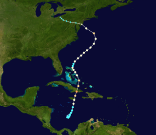
Hurricane Sandy was the sixth-costliest Atlantic hurricane on record. It lasted for over a week in late October-early November 2012. Classified as the eighteenth named storm, tenth hurricane, and second major hurricane of the annual hurricane season, Sandy originated from a tropical wave on October 22. Performing a small loop over the central Caribbean Sea, the system intensified into a tropical storm a day later and became the final hurricane of the season before briefly coming ashore the coast of Jamaica on October 24. After emerging between Jamaica and Cuba, Sandy began a period of rapid intensification into a Category 3 hurricane on the Saffir–Simpson hurricane wind scale, with maximum sustained winds of 115 mph (185 km/h). It made landfall at this intensity near Santiago de Cuba on October 25.

Sea ice in the Arctic region has declined in recent decades in area and volume due to climate change. It has been melting more in summer than it refreezes in winter. Global warming, caused by greenhouse gas forcing is responsible for the decline in Arctic sea ice. The decline of sea ice in the Arctic has been accelerating during the early twenty-first century, with a decline rate of 4.7% per decade. Summertime sea ice will likely cease to exist sometime during the 21st century.

The November 2014 Bering Sea cyclone was the most intense extratropical cyclone ever recorded in the Bering Sea, which formed from a new storm developing out of the low-level circulation that separated from Typhoon Nuri, which soon absorbed the latter. The cyclone brought gale-force winds to the western Aleutian Islands and produced even higher gusts in other locations, including a 97 miles per hour (156 km/h) gust in Shemya, Alaska. The storm coincidentally occurred three years after another historic extratropical cyclone impacted an area slightly further to the east.

The October 2022 Southern Ocean cyclone, also referred to as the Peter I storm or EC2022 was the most intense extratropical cyclone on record. Forming as a weak depression near Tonga late on 9 October, the extratropical cyclone tracked slowly southeastward across the South Pacific, remaining weak. Starting on 14 October, the cyclone began rapid deepening as it moved towards Antarctica. Deepening rates peaked on 16 October, where the pressure fell as rapidly as 19 mbar (0.56 inHg) over a six-hour period. The storm peaked early on 17 October in the Bellingshausen Sea, with a minimum pressure of around 900 mbar (26.58 inHg). The cyclone moved slowly in a loop, rising in pressure over the next few days before dissipating on 20 October.
