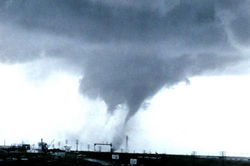
A multiple-vortex tornado is a tornado that contains several vortices (called subvortices or suction vortices) revolving around, inside of, and as part of the main vortex. The only times multiple vortices may be visible are when the tornado is first forming or when condensation and debris are balanced such that subvortices are apparent without being obscured. They can add over 100 mph to the ground-relative wind in a tornado circulation and are responsible for most cases where narrow arcs of extreme destruction lie right next to weak damage within tornado paths. [1]
Suction vortices, also known as suction spots, are substructures found in many tornadoes, though they are not always easily visible. These vortices typically occur at the base of the tornado, where it makes contact with the ground. Sub-vortices tend to form after vortex breakdown reaches the surface, resulting from the interaction of cyclonically incoming and rising air. Although multi-vortex structures are common in tornadoes, they are not unique to them and can occur in other circulations, such as dust devils. This is a natural result of vortex dynamics in physics. Multi-vortex tornadoes should not be confused with cyclically tornadic supercells. Supercells are large, rotating thunderstorms that can produce multiple, distinct tornadoes, often referred to as tornado families. These tornadoes may form at different times or exist simultaneously but are separate from one another.
A phenomenon similar to multiple vortices is the satellite tornado. Unlike the multiple-vortex tornado, where smaller vortices form inside the main tornado, a satellite tornado develops outside the main tornado's circulation. It forms through a different mechanism, typically as a result of interactions with the parent storm's environment. Despite appearing close to the primary tornado, satellite tornadoes are independent and can have their own rotation. [1]
The largest tornado ever documented was a multiple-vortex tornado. It struck El Reno, Oklahoma, on May 31, 2013, as a rain-wrapped tornado, taking the lives of tornado researcher Tim Samaras, his son Paul, and their TWISTEX colleague, Carl Young. This storm also took the life of local amateur chaser, Richard Henderson. [2] It had a maximum width of 2.6 miles (4.2 km) and a maximum recorded windspeed of at least 313 miles per hour (504 km/h). However, because of a lack of intense property damage, the tornado achieved a rating of EF3 on the Enhanced Fujita scale. [3] Nevertheless, the El Reno tornado is one of the two strongest tornadoes ever recorded in terms of maximum wind speeds, the other being the 1999 Bridge Creek–Moore tornado which doppler radar measured 321 miles per hour (517 km/h) mph.
The 1997 Jarrell tornado was another example of a multiple-vortex tornado. The infamous “Dead Man Walking” photo of it was at a juvenile stage of sub-vortices development. The 2011 Cullman–Arab tornado is also famous for footage of it "walking" while in its multi-vortex stage.
A tornado is a violently rotating column of air that is in contact with both the surface of the Earth and a cumulonimbus cloud or, in rare cases, the base of a cumulus cloud. It is often referred to as a twister, whirlwind or cyclone, although the word cyclone is used in meteorology to name a weather system with a low-pressure area in the center around which, from an observer looking down toward the surface of the Earth, winds blow counterclockwise in the Northern Hemisphere and clockwise in the Southern. Tornadoes come in many shapes and sizes, and they are often visible in the form of a condensation funnel originating from the base of a cumulonimbus cloud, with a cloud of rotating debris and dust beneath it. Most tornadoes have wind speeds less than 180 kilometers per hour, are about 80 meters across, and travel several kilometers before dissipating. The most extreme tornadoes can attain wind speeds of more than 480 kilometers per hour (300 mph), can be more than 3 kilometers (2 mi) in diameter, and can stay on the ground for more than 100 km (62 mi).
A supercell is a thunderstorm characterized by the presence of a mesocyclone, a deep, persistently rotating updraft. Due to this, these storms are sometimes referred to as rotating thunderstorms. Of the four classifications of thunderstorms, supercells are the overall least common and have the potential to be the most severe. Supercells are often isolated from other thunderstorms, and can dominate the local weather up to 32 kilometres (20 mi) away. They tend to last 2–4 hours.
A mesocyclone is a meso-gamma mesoscale region of rotation (vortex), typically around 2 to 6 mi in diameter, most often noticed on radar within thunderstorms. In the northern hemisphere it is usually located in the right rear flank of a supercell, or often on the eastern, or leading, flank of a high-precipitation variety of supercell. The area overlaid by a mesocyclone’s circulation may be several miles (km) wide, but substantially larger than any tornado that may develop within it, and it is within mesocyclones that intense tornadoes form.
From May 2 to 8, 1999, a large tornado outbreak took place across much of the Central and parts of the Eastern United States, as well as southern Canada. During this week-long event, 152 tornadoes touched down in these areas. The most dramatic events unfolded during the afternoon of May 3 through the early morning hours of May 4 when more than half of these storms occurred. Oklahoma experienced its largest tornado outbreak on record, with 70 confirmed. The most notable of these was the F5 Bridge Creek–Moore tornado which devastated Oklahoma City and suburban communities. The tornado killed 36 people and injured 583 others; losses amounted to $1 billion, making it the first billion-dollar tornado in history. Overall, 50 people lost their lives during the outbreak and damage amounted to $1.4 billion. For these reasons, the outbreak is known in Oklahoma as the May 3rd outbreak or the Oklahoma tornado outbreak of 1999.
This article lists various tornado records. The most "extreme" tornado in recorded history was the Tri-State tornado, which spread through parts of Missouri, Illinois, and Indiana on March 18, 1925. It is considered an F5 on the Fujita Scale, holds records for longest path length at 219 miles (352 km) and longest duration at about 3+1⁄2 hours. The 1974 Guin tornado had the highest forward speed ever recorded in a violent tornado, at 75 mph (121 km/h). The deadliest tornado in world history was the Daulatpur–Saturia tornado in Bangladesh on April 26, 1989, which killed approximately 1,300 people. In the history of Bangladesh, at least 19 tornadoes killed more than 100 people each, almost half of the total for the world. The most extensive tornado outbreak on record was the 2011 Super Outbreak, which resulted in 367 tornadoes and 324 tornadic fatalities, whereas the 1974 Super Outbreak was the most intense tornado outbreak on tornado expert Thomas P. Grazulis's outbreak intensity score with 578, as opposed to the 2011 outbreak's 378.
The Late-May 1998 tornado outbreak and derecho was a historic tornado outbreak and derecho that began on the afternoon of May 30 and extended throughout May 31, 1998, across a large portion of the northern half of the United States and southern Ontario from southeastern Montana east and southeastward to the Atlantic Ocean. The initial tornado outbreak, including the devastating Spencer tornado, hit southeast South Dakota on the evening of May 30. The Spencer tornado was the most destructive and the second-deadliest tornado in South Dakota history. A total of 13 people were killed; 7 by tornadoes and 6 by the derecho. Over two million people lost electrical power, some for up to 10 days.
An anticyclonic storm is a storm with a high-pressure center, in which winds flow in the direction opposite to that of the flow above a region of low pressure. Unlike a cyclonic storm, anticyclonic storms are typically associated with fair weather and stable atmospheric conditions. On other planets or in rare cases on Earth, anticyclones can contribute to inclement weather. Examples include Hartmut, which brought a blizzard to the British Isles in 2018, as well as persistent anticyclonic storms on Jupiter and Neptune.
A funnel cloud is a funnel-shaped cloud of condensed water droplets, associated with a rotating column of wind and extending from the base of a cloud but not reaching the ground or a water surface. A funnel cloud is usually visible as a cone-shaped or needle like protuberance from the main cloud base. Funnel clouds form most frequently in association with supercell thunderstorms, and are often, but not always, a visual precursor to tornadoes. Funnel clouds are visual phenomena, but these are not the vortex of wind itself.
A gustnado is a brief, shallow surface-based vortex which forms within the downburst emanating from a thunderstorm. The name is a portmanteau by elision of "gust front tornado", as gustnadoes form due to non-tornadic straight-line wind features in the downdraft (outflow), specifically within the gust front of strong thunderstorms. Gustnadoes tend to be noticed when the vortices loft sufficient debris or form condensation cloud to be visible although it is the wind that makes the gustnado, similarly to tornadoes. As these eddies very rarely connect from the surface to the cloud base, they are very rarely considered as tornadoes. The gustnado has little in common with tornadoes structurally or dynamically in regard to vertical development, intensity, longevity, or formative process—as classic tornadoes are associated with mesocyclones within the inflow (updraft) of the storm, not the outflow.
A bow echo is the characteristic radar return from a mesoscale convective system that is shaped like an archer's bow. These systems can produce severe straight-line winds and occasionally tornadoes, causing major damage. They can also become derechos or form Line echo wave pattern (LEWP).
The eye is a region of mostly calm weather at the center of a tropical cyclone. The eye of a storm is a roughly circular area, typically 30–65 kilometers in diameter. It is surrounded by the eyewall, a ring of towering thunderstorms where the most severe weather and highest winds of the cyclone occur. The cyclone's lowest barometric pressure occurs in the eye and can be as much as 15 percent lower than the pressure outside the storm.
Convective storm detection is the meteorological observation, and short-term prediction, of deep moist convection (DMC). DMC describes atmospheric conditions producing single or clusters of large vertical extension clouds ranging from cumulus congestus to cumulonimbus, the latter producing thunderstorms associated with lightning and thunder. Those two types of clouds can produce severe weather at the surface and aloft.
The Verification of the Origins of Rotation in Tornadoes Experiment are field experiments that study tornadoes. VORTEX1 was the first time scientists completely researched the entire evolution of a tornado with an array of instrumentation, enabling a greater understanding of the processes involved with tornadogenesis. A violent tornado near Union City, Oklahoma was documented in its entirety by chasers of the Tornado Intercept Project (TIP) in 1973. Their visual observations led to advancement in understanding of tornado structure and life cycles.
A mesovortex is a small-scale rotational feature found in a convective storm, such as a quasi-linear convective system, a supercell, or the eyewall of a tropical cyclone. Mesovortices range in diameter from tens of miles to a mile or less and can be immensely intense.
A prolonged and widespread tornado outbreak affected a large portion of the United States in late-May 2013 and early-June 2013. The outbreak was the result of a slow-moving but powerful storm system that produced several strong tornadoes across the Great Plains states, especially in Kansas and Oklahoma. Other strong tornadoes caused severe damage in Nebraska, Missouri, Illinois, and Michigan. The outbreak extended as far east as Upstate New York. 27 fatalities were reported in total, with nine resulting from tornadoes.
Timothy Michael Samaras was an American engineer and storm chaser best known for his field research on tornadoes and time on the Discovery Channel show Storm Chasers. He died in the 2013 El Reno tornado.
The 2013 El Reno tornado was an extremely large, powerful, and erratic tornado that occurred over rural areas of Central Oklahoma during the early evening of Friday, May 31, 2013. This rain-wrapped, multiple-vortex tornado was the widest tornado ever recorded and was part of a larger weather system that produced dozens of tornadoes over the preceding days. The tornado initially touched down at 6:03 p.m. Central Daylight Time (2303 UTC) about 8.3 miles (13.4 km) west-southwest of El Reno, rapidly growing in size and becoming more violent as it tracked through central portions of Canadian County. Remaining over mostly open terrain, the tornado did not impact many structures; however, measurements from mobile weather radars revealed extreme winds in excess of 313 mph (504 km/h) within the vortex. These are among the highest observed wind speeds on Earth, just slightly lower than the wind speeds of the 1999 Bridge Creek–Moore tornado. As it crossed U.S. 81, it had grown to a record-breaking width of 2.6 miles (4.2 km), beating the previous width record set in 2004. Turning northeastward, the tornado soon weakened. Upon crossing Interstate 40, the tornado dissipated around 6:43 p.m. CDT (2343 UTC), after tracking for 16.2 miles (26.1 km), it avoided affecting the more densely populated areas near and within the Oklahoma City metropolitan area.
The following is a glossary of tornado terms. It includes scientific as well as selected informal terminology.
The 2011 El Reno–Piedmont tornado was a long-tracked and deadly EF5 tornado that struck central Oklahoma on the evening of May 24, 2011. The tornado impacted areas near or within the communities of El Reno, Piedmont, and Guthrie, killing nine and injuring 181. After producing incredible damage in several locations along a path of more than 60 miles (97 km), the El Reno–Piedmont tornado was given a rating of EF5, the highest category on the Enhanced Fujita scale, as well as being the highest rated tornado on the scale since its implementation in 2007, with estimated peak winds >210 mph (337 km/h). It was also the first tornado rated EF5 or F5 to strike Oklahoma since the 1999 Bridge Creek–Moore tornado. A mobile radar found that the tornado possessed possible wind speeds of up to 295 mph (475 km/h).
A descending reflectivity core (DRC), sometimes referred to as a blob, is a meteorological phenomenon observed in supercell thunderstorms, characterized by a localized, small-scale area of enhanced radar reflectivity that descends from the echo overhang into the lower levels of the storm. Typically found on the right rear flank of supercells, DRCs are significant for their potential role in the development or intensification of low-level rotation within these storms. The descent of DRCs has been associated with the formation and evolution of hook echoes, a key radar signature of supercells, suggesting a complex interplay between these cores and storm dynamics.