WSR-74

Last updated
WSR-74
WSR-74C at Springfield IL.jpg
WSR-74C radar from Central Illinois WFO.
Country of origin United States
Introduced1974 (1974)
No. built68 WSR-74C
5 WSR-74S
Type Weather radar
Frequency2890 MHz (WSR-74S S band)
5400 MHz (WSR-74C C band)
PRF 259 Hz (WSR-74C)
545 and 162 Hz (WSR-74S)
Beamwidth 1.6° (WSR-74C)
2° (WSR-74S)
Pulsewidth3 μs (WSR-74C)
1 and 4 μs (WSR-74S)
Range579 km
Diameter2.6 m (8.5 ft) (WSR-74C)
3.7 m (12 ft) (WSR-74S)
Precision0.9 km (0.56 mi) in range
Power250 KW (WSR-74C)
500 KW (WSR-74S)

WSR-74 radars were Weather Surveillance Radars designed in 1974 for the National Weather Service. They were added to the existing network of the WSR-57 model to improve forecasts and severe weather warnings. Some have been sold to other countries like Australia, Greece, and Pakistan.

Contents

Radar properties

There are two types in the WSR-74 series, which are almost identical except for operating frequency. [1] The WSR-74C (used for local warnings) operates in the C band, and the WSR-74S (used in the national network) operates in the S band (like the WSR-57 and the current WSR-88D). S band frequencies are better suited because they are not attenuated significantly in heavy rain while the C Band is strongly attenuated, and has a generally shorter maximum effective range.

The WSR-74C uses a wavelength of 5.4 cm. [2] It also has a dish diameter of 8 feet, and a maximum range of 579 km (313 nm) as it was used only for reflectivities (see Doppler dilemma).

History

WSR-74C Radar in Darwin, Northern Territory Australia Berrimah-radar-darwin-nt.jpg
WSR-74C Radar in Darwin, Northern Territory Australia

The WSR-57 network was very spread out, with 66 radars to cover the entire country. There was little to no overlap in case one of these vacuum-tube radars went down for maintenance. The WSR-74 was introduced as a "gap filler", as well as an updated radar that, among other things, was transistor-based. [3] In the early 1970s, Enterprise Electronics Corporation (EEC), based out of Enterprise, Alabama won the contract to design, manufacture, test, and deliver the entire WSR-74 radar network (both C and S-Band versions).

WSR-74C radars were generally local-use radars that didn't operate unless severe weather was expected, while WSR-74S radars were generally used to replace WSR-57 radars in the national weather surveillance network. When a network radar went down, a nearby local radar might have to supply updates like a network radar. [4] NWS Lubbock received the first WSR-74C in August 1973 following widespread attention from the F5 Lubbock tornado of 1970. [5]

128 [6] of the WSR-57 and WSR-74 model radars were spread across the country as the National Weather Service's radar network until the 1990s. They were gradually replaced by the WSR-88D model (Weather Surveillance Radar - 1988, Doppler), constituting the NEXRAD network. The WSR-74 had served the NWS for two decades.

The last WSR-74C used by the NWS was located in Williston, ND, before being decommissioned at the end of 2012. [7]

No WSR-74S's are in the NWS inventory today, having been replaced by the WSR-88D, but some of these radars are in commercial use.

Radar sites in the US

Circles showing the coverage of the WSR-57 and WSR-74 radars. Note the large gap over the western United States. WSR-74 and WSR-57 weather radar network United States.png
Circles showing the coverage of the WSR-57 and WSR-74 radars. Note the large gap over the western United States.

WSR-74 sites include the following two categories: [8] [9]

WSR-74C SiteCommissionedDecommissioned
Abilene, TX (ABI)August 27, 1977April 30, 1997
Akron, OH (CAK)June 1, 1977November 15, 1995
Albany, NY (ALB)July 27, 1977November 2, 1995
Alpena, MI (APN)June 8, 1977December 9, 1996
Atlanta, GA (ATL)

Was atop the WSFO building at 3420 Norman Berry Drive

October 20, 1976February 1, 1996
Augusta, GA (AGS)July 1, 1976July 30, 1996
Austin, TX (AUS)April 9, 1976October 13, 1995
Baton Rouge, LA (BTR)October 20, 1978May 14, 1996
Beckley, WV (BKW)November 1, 1977January 12, 1996
Billings, MT (BIL)April 18, 1978May 30, 1996
Bismarck, ND (BIS)October 5, 1978February 28, 1996
Burlington, VT (BTV)Late 1977January 29, 1998
Charlotte, NC (CLT)February 28, 1978September 17, 1996
Chattanooga, TN (CHA)Early 1980sJune 10, 1998
Cheyenne, WY (CYS)September 15, 1976April 24, 1996
Cleveland, OH (CLE)August 4, 1976

Replaced a WSR-3.

November 15, 1995
Columbia, MO (COU)November 9, 1977

Replaced a WSR-3.

June 19, 1996
Columbia, SC (CAE)January 26, 1976

Replaced a WSR-1.

October 25, 1995
Columbus, GA (CSG)April 2, 1979April 3, 1996
Columbus, OH (CMH)June 9, 1977

Replaced a WSR-3.

December 1, 1995
Concordia, KS (CNK)February 18, 1977

Replaced a WSR-3.

November 9, 1995
Corpus Christi, TX (CRP)February 1, 1976 March 10, 1997
Duluth, MN (DLH)1977March 25, 1997
Erie, PA (ERI)August 30, 1977January 15, 2000?
Fort Smith, AR (FSM)November 25, 1975

Replaced a WSR-3.

July 7, 1998
Fort Wayne, IN (FWA)March 12, 1976

Replaced a WSR-3.

July 8, 1998
Goodland, KS (GLD)June 6, 1978

Replaced a WSR-3.

October 25, 1995
Harrisburg, PA (HAR)

Atop the Federal Building

June 28, 1977January 12, 1996
Hartford, CT (BDL)April 1977November 2, 1995
Houghton Lake, MI (HTL)February 1, 1977December 9, 1996
Huntsville, AL (HSV)

(Doppler capability after July 1991)

1977.

Replaced a WSR-3.

December 15, 1999?

Now the ARMOR radar, still used by Local Media/NWS.

Indianapolis, IN (IND)September 28, 1977February 28, 1996
Las Vegas, NV (LAS)1976September 1, 1995
Los Angeles, CA (LAX)

On top of the Federal Building in Westwood to this day.

May 15, 1995
Louisville, KY (SDF)April or May 1978July 19, 1994
Lubbock, TX (LBB)August 1973April 3, 1996
Macon, GA (MCN)April 18, 1977April 3, 1996
Madison, WI (MSN)

At Madison Airport.

June 19, 1979

Replaced a WSR-3

May 7, 1996
Marquette, MI (MQT)July 16, 1996
Meridian, MS (MEI)November 2, 1976December 26, 1996
Mobile, AL (MOB)October 12, 1995
Moline, IL (MLI) August 30, 1977January 19, 1996
Montgomery, AL (MGM)

(Doppler capability after 1982)

1977June 4, 1996
Muskegon, MI (MKG)March 25, 1976August 13, 1996
Norfolk, NE (OFK)May 14, 1976March 25, 1997
North Platte, NE (LBF)November 27, 1996
Omaha, NE (OVN)1977July 10, 1996
Paducah, KY (PAH)

At the Paducah Airport.

1984February 23, 1996
Phoenix, AZ (PHX)August 15, 1994
Portland, OR (PDX)January 30, 1996
Raleigh, NC (RDU)May 19, 1977December 22, 1995
Rapid City, SD (RAP)November 4, 1996
Rochester, MN (RST)April 1976January 9, 1997
San Angelo, TX (SJT)October 1977April 22, 1997
Savannah, GA (SAV)November 15, 1982February 11, 1997
Shreveport, LA (SHV)June 1976June 5, 1996
Sioux Falls, SD (FSD)1976October 4, 1996
South Bend, IN (SBN)October 22, 1982July 8, 1998
Springfield, IL (SPI) October 16, 1980July 30, 1996
Topeka, KS (TOP)1976November 2, 1995
Tucson, AZ (TUS)January 1983March 14, 1996
Tulsa, OK (TUL)March 12, 1976April 5, 1995
Tupelo, MS (TUP)April 1, 1983December 6, 1995
Waco, TX (ACT)November 8, 1976 September 13, 1995
Waterloo, IA (ALO)November 19, 1976January 17, 1997
Wichita Falls, TX (SPS)February 5, 1977December 26, 1996
Williston, ND (ISN)February 21, 1978December 31, 2012
Worcester, MA (ORH)July 2, 1976April 5, 1995
WSR-74S SiteCommissionedDecommissioned
Alliance, NE (AIA)June 10, 1977January 17, 1997
Binghamton, NY (BGM)March 8, 1978September 26, 1995
Charleston, WV (CRW)

WSR-74S providing local coverage

May 16, 1977January 12, 1996
Chatham, MA (CHH)May 6, 1983April 5, 1995
Detroit, MI (DTW)March 9, 1984

Replaced a WSR-57.
November 9, 1995
Fargo, ND (FAR)February 1, 1978

Was a WSR-74C from Oct. 9, 1976 to Nov. 27, 1977
November 27, 1996
Jackson, KY (JKL)
WSR-74S providing local coverage
April 1, 1981July 1, 1997
Key West, FL (EYW) May 9, 1983

Replaced a WSR-57.

October 20, 1998
Longview, TX (GGG)March 1, 1978March 14, 1996
Marseilles, IL (MMO)

(Doppler capability)

November 1, 1974.

Replaced a WSR-57 at Chicago.

January 19, 1996
Memphis, TN (MEG)

At East Memphis/Agricenter site

January 1986.

Replaced a WSR-57.

June 21, 1995
Patuxent River, MD (NHK)

At Patuxent River NAS

Early 1980s.

Replaced a WSR-57 at Washington, DC.

November 17, 1995
Portland, ME (PWM)March 5, 1985

Replaced a WSR-57.
September 13, 1995
San Juan, Puerto Rico (SJU)

WSR-74S providing local coverage

February 26, 1999
Volens, VA (VQN/7VM)April 12, 1977December 1, 1995
West Palm Beach, FL (PBI)

WSR-74S providing local coverage. Became part of the national network after the WSR-57 at Miami was destroyed in Hurricane Andrew.

December 17, 1980October 13, 1995

See also

Related Research Articles

<span class="mw-page-title-main">NEXRAD</span> Network of weather radars operated by the NWS

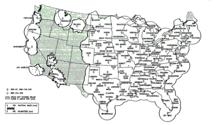
NEXRAD or Nexrad is a network of 159 high-resolution S-band Doppler weather radars operated by the National Weather Service (NWS), an agency of the National Oceanic and Atmospheric Administration (NOAA) within the United States Department of Commerce, the Federal Aviation Administration (FAA) within the Department of Transportation, and the U.S. Air Force within the Department of Defense. Its technical name is WSR-88D.

<span class="mw-page-title-main">WSR-57</span> Weather radar used by the U.S. Weather Bureau

WSR-57 radars were the USA's main weather surveillance radar for over 35 years. The National Weather Service operated a network of this model radar across the country, watching for severe weather.

<span class="mw-page-title-main">Weather radar</span> Radar used to locate and monitor meteorological conditions

Weather radar, also called weather surveillance radar (WSR) and Doppler weather radar, is a type of radar used to locate precipitation, calculate its motion, and estimate its type. Modern weather radars are mostly pulse-Doppler radars, capable of detecting the motion of rain droplets in addition to the intensity of the precipitation. Both types of data can be analyzed to determine the structure of storms and their potential to cause severe weather.

<span class="mw-page-title-main">Hook echo</span> Weather radar signature indicating tornadic circulation in a supercell thunderstorm

A hook echo is a pendant or hook-shaped weather radar signature as part of some supercell thunderstorms. It is found in the lower portions of a storm as air and precipitation flow into a mesocyclone, resulting in a curved feature of reflectivity. The echo is produced by rain, hail, or even debris being wrapped around the supercell. It is one of the classic hallmarks of tornado-producing supercells. The National Weather Service may consider the presence of a hook echo coinciding with a tornado vortex signature as sufficient to justify issuing a tornado warning.

The National Severe Storms Laboratory (NSSL) is a National Oceanic and Atmospheric Administration (NOAA) weather research laboratory under the Office of Oceanic and Atmospheric Research. It is one of seven NOAA Research Laboratories (RLs).

<span class="mw-page-title-main">Aggie Doppler Radar</span>

The Aggie Doppler Radar (ADRAD) is a Doppler weather radar located on the roof of the Eller Oceanography & Meteorology Building on the Texas A&M University campus in College Station, Texas.

<span class="mw-page-title-main">ARMOR Doppler Weather Radar</span>

ARMOR Doppler weather radar is a C-Band, Dual-Polarimetric Doppler Weather Radar, located at the Huntsville International Airport in Huntsville, Alabama. The radar is a collaborative effort between WHNT-TV and the University of Alabama in Huntsville. Live data for the radar is only available to a limited audience, such as UAH employees and NWS meteorologists. All ARMOR data is archived at the National Space Science and Technology Center located on the UAH campus.

The AN/APS-2, originally known as ASG, was a surface search radar developed by Philco originally for use in US Coast Guard blimps to detect German submarines. It proved better than several similar models then being built, and was ordered by the RAF Coastal Command where it was known as ASV Mark V. It was used primarily on British Liberator GR bombers, where they were instrumental in closing the Mid-Atlantic Gap and the subsequent destruction of the German U-boat fleet in May/June 1943.

<span class="mw-page-title-main">WSR-1</span>

The WSR-1 or Weather Surveillance Radar-1 was one of the first weather radars and the first used by a civilian organization in the US. The WSR-1 series was a modified version of the AN/APS-2F radar, which the Weather Bureau acquired from the Navy. The WSR-1A, WSR-3, and WSR-4 were also variants of this radar. The first WSR-1 in the USA was at Washington National Airport in Washington, D.C. in 1947, and the last WSR-3 was retired by 1978.

<span class="mw-page-title-main">Warning Decision Training Division</span>

The Warning Decision Training Division (WDTD), known as the Warning Decision Training Branch until April 1, 2015, is one of three training organizations in the NWS Training Division which also includes the Forecast Decision Training Branch and the NWS Training Center. WDTD develops and delivers training on the integrated elements of the warning process within a National Oceanic and Atmospheric Administration (NOAA)/National Weather Service (NWS) forecast office. WDTD instructors develop and deliver a variety of in-residence, teletraining, and on-line asynchronous training content.

<span class="mw-page-title-main">Terminal Doppler Weather Radar</span>

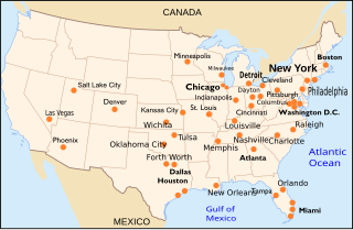
Terminal Doppler Weather Radar (TDWR) is a Doppler weather radar system with a three-dimensional "pencil beam" used primarily for the detection of hazardous wind shear conditions, precipitation, and winds aloft on and near major airports situated in climates with great exposure to thunderstorms in the United States. As of 2011, all were in-service with 45 operational radars, some covering multiple airports in major metropolitan locations, across the United States & Puerto Rico. Several similar weather radars have also been sold to other countries such as China (Hong Kong). Funded by the United States Federal Aviation Administration (FAA), TDWR technology was developed in the early 1990s at Lincoln Laboratory, part of the Massachusetts Institute of Technology, to assist air traffic controllers by providing real-time wind shear detection and high-resolution precipitation data.

<span class="mw-page-title-main">National Weather Service Lincoln, Illinois</span> Forecast office in central Illinois

National Weather Service Lincoln, Illinois also known as National Weather Service Central Illinois is a weather forecast office responsible for monitoring weather conditions for 35 counties in Central and Southeastern Illinois. The Central Illinois office initially consisted of two forecast offices in Peoria and Springfield until the current location in Lincoln became the sole local forecast office in 1995. Federal meteorology offices and stations in the region date back to the 19th century when the Army Signal Service began taking weather observations using weather equipment at the Springer Building in Springfield. Since that time the presence of the National Weather Service greatly increased with the installation of new weather radars, stations and forecast offices. The current office in Lincoln maintains a WSR-88D (NEXRAD) radar system, and Advanced Weather Interactive Processing System (AWIPS) that greatly improve forecasting in the region. Lincoln is in charge of weather forecasts, warnings and local statements as well as aviation weather.

<span class="mw-page-title-main">National Weather Service Memphis, Tennessee</span>

National Weather Service - Memphis, TN is a local weather forecast office responsible for monitoring weather conditions in the U.S. Mid-South region for counties in Eastern Arkansas, the Missouri Bootheel, Northern Mississippi, and Western Tennessee. The current office in Memphis maintains a WSR-88D (NEXRAD) radar system, and Advanced Weather Interactive Processing System (AWIPS) that greatly improve forecasting in the region. Memphis is in charge of weather forecasts, warnings and local statements as well as aviation weather. The name of the Doppler weather radar (WSR-88D) used by this office is MEG. Darone Jones is the Meteorologist-In-Charge (MIC) of this office.

<span class="mw-page-title-main">National Weather Service Tulsa, Oklahoma</span>

National Weather Service - Tulsa, Oklahoma (TSA) is a local weather forecast office responsible for monitoring weather conditions for 7 counties in Northwestern Arkansas, and 25 counties in Eastern Oklahoma. The current office in Tulsa maintains a WSR-88D (NEXRAD) radar system, and Advanced Weather Interactive Processing System (AWIPS) that greatly improve forecasting in the region. Tulsa is in charge of weather forecasts, warnings and local statements as well as aviation weather and NOAA Weather Radio broadcasts in its service area. The office operates two Doppler weather radars, one in Tulsa (INX), and the other in Fort Smith, Arkansas (SRX). Steve Piltz is the Meteorologist-In-Charge (MIC) of this office.

National Weather Service Jackson, based in Jackson, Kentucky, is a weather forecast office responsible for monitoring weather conditions for 33 counties in Eastern Kentucky. The National Weather Service chose to put a weather forecast office (WFO) in eastern Kentucky due to the flooding of April 2-5, 1977. The National Weather Service Jackson, Kentucky has been forecasting for portions of Eastern Kentucky since 1981.

<span class="mw-page-title-main">National Weather Service Kansas City/Pleasant Hill, Missouri</span> NWS Forecast Office serving west central Missouri, east central Kansas

National Weather Service - Pleasant Hill/Kansas City, Missouri is a Weather Forecast Office (WFO) of the National Weather Service, which is responsible for forecasts and the dissemination of weather warnings and advisories for 37 counties in northern and western Missouri and seven counties in extreme eastern Kansas, including the Kansas City and St. Joseph metropolitan areas. Though, as the Storm Prediction Center (SPC) in Norman, Oklahoma is responsible for issuing severe thunderstorm and tornado watches, the Pleasant Hill/Kansas City WFO only composes outline and status updates for SPC-issued watches affecting any portion of its designated County Warning Area.

<span class="mw-page-title-main">SMART-R</span>

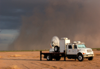
The Shared Mobile Atmospheric Research and Teaching Radar, colloquially known as SMART-R or SR, is a mobile Doppler weather radar platform operated and created by University of Oklahoma (OU) with aide from Texas A&M and Texas Tech University in 2001.

<span class="mw-page-title-main">National Weather Service Raleigh, North Carolina</span>

The National Weather Service Raleigh, North Carolina (RAH) is a local Weather Forecast Office for central North Carolina. The NWS in Raleigh serves 31 counties in NC and these 31 counties have a population of 7.74 million people, including the cities of Raleigh, Durham, Greensboro, Winston-Salem, and Fayetteville, North Carolina.

<span class="mw-page-title-main">National Weather Service Gray/Portland, Maine</span>

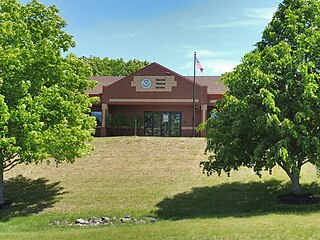
The National Weather Service Gray/Portland, Maine (GYX) is a local office of the National Weather Service responsible for monitoring weather conditions over western Maine and all of New Hampshire. It is situated in Gray, Maine, in the metropolitan area of Portland, in a rural setting.

<span class="mw-page-title-main">Langley Hill Doppler radar</span>

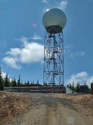
The Langley Hill Doppler radar (KLGX) is a National Weather Service NEXRAD Doppler weather radar station on the Pacific coast of Washington State, in the United States. Prior to its construction, Washington's Olympic Peninsula coast was the only portion of the U.S. coastline without weather radar coverage, and "virtually no radar coverage [is] available over the ocean, where the majority of western Washington's weather originates" according to a Weather Service report to the United States Congress.

References

  1. "Advanced Search - ITS" (PDF). bldrdoc.gov. Retrieved 19 March 2015.
  2. Paul Sirvatka. "WSR - Weather Surveillance Radar." Radar. College of DuPage. 4 Apr. 2006 <http://weather.cod.edu/sirvatka/radar.html>.
  3. Whiton, Roger C.; Smith, Paul L.; Bigler, Stuart G.; Wilk, Kenneth E.; Harbuck, Albert C. (1 June 1998). "History of Operational Use of Weather Radar by U.S. Weather Services. Part I: The Pre-NEXRAD Era". Weather and Forecasting . 13 (2). American Meteorological Society: 219–243. doi: 10.1175/1520-0434(1998)013<0219:HOOUOW>2.0.CO;2 . eISSN   1520-0434. ISSN   0882-8156. S2CID   122880960.
  4. Stormtrack.org Forum 9498 [ permanent dead link ]
  5. "NWS Lubbock, TX Office History". noaa.gov. Retrieved 19 March 2015.
  6. http://sysu1.wsicorp.com/unidata/intro.html Archived April 20, 2008, at the Wayback Machine
  7. "Weather radar shutdown imminent". Williston Herald. Retrieved 19 March 2015.
  8. "Assessment of Nexrad Coverage and Associated Weather Services". nap.edu. Retrieved 19 March 2015.
  9. Stormtrack.org Forum 10344 [ permanent dead link ]