Multifunction Phased Array Radar

Last updated
Multifunction Phased Array Radar
Par installation.jpg
MPAR being installed in 2003.
Country of originUSA
Introduced2003
No. built1
TypeWeather/Air-traffic radar
Frequency3,200 MHz (S band)
PRF 918 Hz
Beamwidth broadside 1.6° - 2.2° at 45° [1]
PulsewidthAdjustable to 2.5 μs
RPMMechanically steered
Altitude360 m (1,180 ft)
Diameter3.7 m (12 ft)
Azimuth Mechanically steered - 4+ antennas anticipated with operational deployment
Elevationup to 60º
Power750 kW

Multifunction Phased Array Radar (MPAR) was an experimental Doppler radar system that utilized phased array technology. MPAR could scan at angles as high as 60 degrees in elevation, and simultaneously track meteorological phenomena, biological flyers, non-cooperative aircraft, and air traffic. From 2003 through 2016, there was one operational MPAR within the mainland United States—a repurposed AN/SPY-1A radar set loaned to NOAA by the U.S. Navy. [2] The MPAR was decommissioned and removed in 2016.

Contents

NOAA and the FAA plan to eventually decommission their NEXRAD, TDWR and ASR radars in favor of several hundred phased array radars conceptually similar to MPAR. [3]

History

The MPAR was derived from a U.S. Navy shipborne radar, the AN/SPY-1. First seeing service beginning in 1973 when it was installed on the USS Norton Sound, the AN/SPY-1 became the standard air search radar of the U.S. Navy and the navies of several other allied nations. During use, it was discovered that the false-alarm rate was high due to the radar detecting swarms of insects and clutter from nearby mountainous terrain. [4] Although problematic for a military air defence radar, this is ideal for a weather radar, and made phased array radars a prime candidate for implementation in the meteorological spectrum. As different versions of the AN/SPY family arose through the 1990s, in 2003 the U.S. Navy loaned a surplus AN/SPY-1A radar to NOAA for meteorological research. NOAA built a tower and pedestal to house the antenna and its components at the National Severe Storms Laboratory in Norman, Oklahoma. [5] [6]

Deployment

May 31, 2013 Oklahoma Phased Array Radar Reflectivity May 31, 2013 Oklahoma Phased Array Radar Reflectivity.gif
May 31, 2013 Oklahoma Phased Array Radar Reflectivity

Conventional radars typically use a large, parabolic dish to focus the radar beam, and rely on motors to move the dish in azimuth and elevation. By contrast, phased arrays are an antenna array, composed of many small antennas on a flat panel, which steer the radar beam electronically by changing the phase of the signal emitted from each antenna element. The signals from each element add together in the desired direction, and cancel out in other directions, a phenomenon known as interference. This capability can obviate the need for motors and moving parts, which increases the reliability and can decrease the cost of the system. [7] However, the angles in which a flat panel phased array can steer its beam is limited to a maximum of approximately 120°, with 90° being more realistic. This means that four panels, mounted at right angles to each other, are required to provide full 360° coverage—or, fewer panels (even just one), mounted on a rotating pedestal as with a conventional dish radar. [8] An alternative is to construct the radar out of many tall but narrow antenna strips arranged in a cylinder. [8]

From 2003 to 2016, the MPAR formed the core of the National Weather Radar Testbed (NWRT), used as a proof-of-concept test to validate the meteorological potential of phased array radars. The MPAR provided much faster volume scans, comprehensive wind profiling, and more complete insights to supercellular structure, while simultaneously tracking aircraft. [9] Due to the temporal resolution ranging from 30 to 60 seconds and the one-sector scanning solution used by MPAR, severe storm and tornado warning lead times increased as much as 8 minutes from the already existing 13 minutes. [10] [11]

One drawback of the MPAR, when compared to the currently-deployed NEXRAD radars, was that MPAR did not support dual-polarization—that is, the polar orientation of the radar beam. Dual-polarization technology exploits the fact that falling rain droplets have a flattened shape as a result of air resistance, and thus return a different signal in the horizontal plane than in the vertical. [12] Similarly, other objects—snow, hail, birds and insects, smoke—also reflect the radar beam differently in the two planes. These differences are measured by the radar, computer algorithms process the data, and produce conclusions about the nature of the detected precipitation. Polarimetric radar provides improvements in tornado detection, rainfall rate measurements, precipitation type discrimination, and more. [13] [14] [15] Dual-polarization capability was rolled out to the existing NEXRAD radars beginning in 2011, and was complete by April 2013. [16] MPAR, being a 1970s design, did not have polarimetric capability and retrofitting it would have been costly, if not impossible. [17] [18] This limitation was addressed in the MPAR successor (see section below).

Non-meteorological applications

Besides meteorological observation, MPAR was capable of air traffic surveillance — this was the original role of the powerful AN/SPY-1 radars from which MPAR was derived. The capability to detect and track aircraft while simultaneously monitoring the weather attracted the attention of the FAA, which operates numerous radars for air traffic control purposes (e.g., ASR series), as well as localized weather radars near airports (TDWR units) to detect dangers to aircraft such as flocks of birds, wind shear, and microbursts, amongst others. [19] Nine different dish-based radar models could be replaced by one phased array radar. [20] Consolidating these different types of radars and their functions into one model would lead to cost savings by the reduction of up to one third of radars needed, streamlined training and maintenance, and an increase in reliability through commonality of spare parts. [19] [21]

Retirement and successor

Although MPAR was a powerful radar with unique features unavailable to conventional meteorological and air-surveillance radars, it was an old design, using old parts, and its hardware upgrade potential was severely limited; in many respects it was inferior to conventional radars. To make way for a more advanced radar, MPAR was decommissioned and removed from its tower structure on 26 August 2016. [22]

The Advanced Technology Demonstrator flat panel antenna Advanced Technology Demonstrator radar antenna array 02.jpg
The Advanced Technology Demonstrator flat panel antenna

MIT Lincoln Laboratory headed the project to design a dual-polarity MPAR successor, incorporating the many lessons learned from the development and operation of MPAR. [21] The prototype, called the Advanced Technology Demonstrator (ATD), was installed on 12 July 2018 on the tower formerly housing the MPAR, and it is expected to become fully operational in 2019. [22] [23] Like MPAR, the ATD radar is an S band flat panel phased array with a 90° field of view. It is composed of 76 square panels, each with 64 radiating elements (for a total of 4,864 elements) arranged on a 14 foot (4.3 m) antenna, and is mounted on a rotating pedestal similar to those used by NEXRAD dish antennas. [24]

Related Research Articles

<span class="mw-page-title-main">Radar</span> Object detection system using radio waves

Radar is a radiolocation system that uses radio waves to determine the distance (ranging), angle (azimuth), and radial velocity of objects relative to the site. It is used to detect and track aircraft, ships, spacecraft, guided missiles, motor vehicles, map weather formations, and terrain. A radar system consists of a transmitter producing electromagnetic waves in the radio or microwaves domain, a transmitting antenna, a receiving antenna and a receiver and processor to determine properties of the objects. Radio waves from the transmitter reflect off the objects and return to the receiver, giving information about the objects' locations and speeds.

<span class="mw-page-title-main">Phased array</span> Array of antennas creating a steerable beam

In antenna theory, a phased array usually means an electronically scanned array, a computer-controlled array of antennas which creates a beam of radio waves that can be electronically steered to point in different directions without moving the antennas. The general theory of an electromagnetic phased array also finds applications in ultrasonic and medical imaging application and in optics optical phased array.

<span class="mw-page-title-main">Doppler radar</span> Type of radar equipment

A Doppler radar is a specialized radar that uses the Doppler effect to produce velocity data about objects at a distance. It does this by bouncing a microwave signal off a desired target and analyzing how the object's motion has altered the frequency of the returned signal. This variation gives direct and highly accurate measurements of the radial component of a target's velocity relative to the radar. The term applies to radar systems in many domains like aviation, police radar detectors, navigation, meteorology, etc.

<span class="mw-page-title-main">Millimeter cloud radar</span> Weather radar tuned to cloud detection

Millimeter-wave cloud radars, also denominated cloud radars, are radar systems designed to monitor clouds with operating frequencies between 24 and 110 GHz. Accordingly, their wavelengths range from 1 mm to 1.11 cm, about ten times shorter than those used in conventional S band radars such as NEXRAD.

<span class="mw-page-title-main">NEXRAD</span> Network of weather radars operated by the NWS

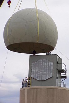
NEXRAD or Nexrad is a network of 159 high-resolution S-band Doppler weather radars operated by the National Weather Service (NWS), an agency of the National Oceanic and Atmospheric Administration (NOAA) within the United States Department of Commerce, the Federal Aviation Administration (FAA) within the Department of Transportation, and the U.S. Air Force within the Department of Defense. Its technical name is WSR-88D.

<span class="mw-page-title-main">Weather radar</span> Radar used to locate and monitor meteorological conditions

Weather radar, also called weather surveillance radar (WSR) and Doppler weather radar, is a type of radar used to locate precipitation, calculate its motion, and estimate its type. Modern weather radars are mostly pulse-Doppler radars, capable of detecting the motion of rain droplets in addition to the intensity of the precipitation. Both types of data can be analyzed to determine the structure of storms and their potential to cause severe weather.

The National Severe Storms Laboratory (NSSL) is a National Oceanic and Atmospheric Administration (NOAA) weather research laboratory under the Office of Oceanic and Atmospheric Research. It is one of seven NOAA Research Laboratories (RLs).

<span class="mw-page-title-main">ARMOR Doppler Weather Radar</span>

ARMOR Doppler weather radar is a C-Band, Dual-Polarimetric Doppler Weather Radar, located at the Huntsville International Airport in Huntsville, Alabama. The radar is a collaborative effort between WHNT-TV and the University of Alabama in Huntsville. Live data for the radar is only available to a limited audience, such as UAH employees and NWS meteorologists. All ARMOR data is archived at the National Space Science and Technology Center located on the UAH campus.

The AN/CPS-9 radar, the first radar specifically designed for meteorological use, was produced in the United States around 1949 and unveiled by the Air Weather Service in 1954.

<span class="mw-page-title-main">Doppler on Wheels</span> Fleet of X-band radar trucks maintained by the Center for Severe Weather Research (CSWR)

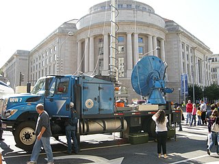
Doppler on Wheels is a fleet of X-band and C-band radar trucks managed by the University of Illinois Urbana-Champaign and previously maintained by the Center for Severe Weather Research (CSWR) in Boulder, Colorado, led by principal investigator (PI) Joshua Wurman, with the funding largely provided by the National Science Foundation (NSF). The DOW fleet and its associated Mobile Mesonets and deployable weather stations (Pods) were Lower Atmospheric Observing Facilities (LAOF) "National Facilities" supporting a wide variety NSF-sponsored research. They are now included in the NSF's "Community Instruments and Facilities" (CIF) program led by PI Karen Kosiba.

Convective storm detection is the meteorological observation, and short-term prediction, of deep moist convection (DMC). DMC describes atmospheric conditions producing single or clusters of large vertical extension clouds ranging from cumulus congestus to cumulonimbus, the latter producing thunderstorms associated with lightning and thunder. Those two types of clouds can produce severe weather at the surface and aloft.

<span class="mw-page-title-main">OU-PRIME</span>

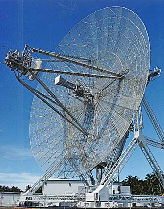
OU-PRIME was an advanced Doppler weather radar. It was completed in January 2009 after a ten-month construction period and commissioned on April 4, 2009. It is operated by the Advanced Radar Research Center (ARRC) at the University of Oklahoma (OU). The radar was manufactured by Enterprise Electronics Corporation to provide OU students and faculty a platform for research and education in the field of radar meteorology. This C-band polarimetric radar has some of the highest resolution data of any C-band weather radar in the United States.

<span class="mw-page-title-main">Tornado debris signature</span>

A tornadic debris signature (TDS), often colloquially referred to as a debris ball, is an area of high reflectivity on weather radar caused by debris lofting into the air, usually associated with a tornado. A TDS may also be indicated by dual-polarization radar products, designated as a polarimetric tornado debris signature (PTDS). Polarimetric radar can discern meteorological and nonmeteorological hydrometeors and the co-location of a PTDS with the enhanced reflectivity of a debris ball are used by meteorologists as confirmation that a tornado is occurring.

<span class="mw-page-title-main">Joint Polarization Experiment</span>

The Joint Polarization Experiment (JPOLE) was a test for evaluating the performance of the WSR-88D in order to modify it to include dual polarization. This program was a joint project of the National Weather Service (NWS), the Federal Aviation Administration (FAA), and the US Air Force Meteorological Agency (AFWA), which took place from 2000-2004. It has resulted in the upgrading of the entire meteorological radar network in the United States by adding dual polarization to better determine the type of hydrometeor, and quantities that have fallen.

<span class="mw-page-title-main">Jeff Kimpel</span> American meteorologist (1942–2020)

James F. "Jeff" Kimpel was an American atmospheric scientist with expertise on severe storms who was a provost of the University of Oklahoma (OU) and director of the National Severe Storms Laboratory (NSSL).

<span class="mw-page-title-main">Australia's weather radars</span>

The majority of Australia's weather radars are operated by the Bureau of Meteorology (BoM), an executive agency of the Australian Government. The radar network is continually being upgraded with new technology such as doppler and dual polarisation to provide better now-casting. Doppler radars are able to detect the movement of precipitation, making it very useful in detecting damaging winds associated with precipitation, and determining if a thunderstorm has a rotating updraft, a key indicator of the presence of the most dangerous type of thunderstorm, a supercell.

<span class="mw-page-title-main">RaXPol</span>

The RapidX-bandPolarimetric Radar, commonly abbreviated as RaXPol, is a mobile research radar designed and operated by the University of Oklahoma, led by Howard Bluestein. RaXPol often collaborates with adjacent mobile radar projects, such as Doppler on Wheels and SMART-R. Unlike its counterparts, RaXPol typically places emphasis on temporal resolution, and as such is capable of surveilling the entire local atmosphere in three dimensions in as little as 20 seconds, or a single level in less than 3 seconds.

<span class="mw-page-title-main">Advanced Technology Demonstrator</span>

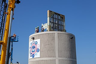
Advanced Technology Demonstrator (ATD) is an experimental weather radar system using Phased Array technology seeking to enhance Phased Array capabilities with the addition of dual-polarity and pulse compression. Its predecessor, MPAR, was the first large-scale PAR experiment taken on by NOAA in 2003, and was deployed until its eventual decommission in favor of ATD in 2016.

<span class="mw-page-title-main">Dusan S. Zrnic</span>

Dušan S. Zrnić is an American engineer of Yugoslav origin, head of the Doppler Weather Radar and Remote Sensing Research Group at the National Severe Storms Laboratory (NSSL) as well as assistant professor of electrical engineering and meteorology at the University of Oklahoma in Norman, Oklahoma. His research interests include circuit design, applied mathematics, magnetohydrodynamics, radar signal processing, and systems design.

<span class="mw-page-title-main">Richard Doviak</span> American engineer and radar pioneer

Richard James Doviak was an American engineer and university professor, pioneer of weather radar. He worked for the National Oceanic and Atmospheric Administration at the National Severe Storms Laboratory developing the NEXRAD radar array using reflectivity, the Doppler effect and the dual polarization to detect precipitation and its movement in clouds. He is also the co-author with Dusan S. Zrnic of the reference book “Doppler Radar and Weather Observations” about modern weather radar and its use.

References

  1. Borowska, Lesya; Zhang, Guifu; Zrnić, Dusan S. (2015). "Considerations for Oversampling in Azimuth on the Phased Array Weather Radar". Journal of Atmospheric and Oceanic Technology. 32 (9): 1614–1629. Bibcode:2015JAtOT..32.1614B. doi: 10.1175/JTECH-D-15-0018.1 .
  2. "Multi-Function Phased Array Radar". NOAA National Severe Storms Laboratory. Retrieved 2019-02-02.
  3. "Research Tools:Multi-Function Phased Array Radar". nssl.noaa.gov. Retrieved 2017-09-26.
  4. Friedman, N. (2006). The Naval Institute Guide to World Naval Weapon Systems. Naval Institute Press. p. 316. ISBN   9781557502629 . Retrieved 2017-09-26.
  5. "Radar". NOAA National Severe Storms Laboratory. Retrieved 2019-02-02.
  6. Hondl, Kurt (2015-02-25). "Multi-Function Phased Array Radar (MPAR) Overview" (PDF). National Severe Storms Laboratory. Archived from the original (PDF) on 2018-10-05. Retrieved 2019-02-02.
  7. "Future Weather Doppler Radar Feasibility Study" (PDF). Office of the Federal Coordinator for Meteorological Services and Supporting Research. 2004-02-26. Archived from the original (PDF) on 2017-06-29. Retrieved 2019-02-01.
  8. 1 2 "Multi-function Phased Array Radar and Cylindrical Polarized Phased Array Radar – Report to Congress" (PDF). 2015. Archived from the original (PDF) on 2019-02-01. Retrieved 2019-02-02.
  9. "Testbeds". NOAA National Severe Storms Laboratory. Retrieved 2019-02-02.
  10. John Cho and Sean Duffy (2011-07-28). "Multifunction Phased Array Radar (MPAR)" (PDF). Retrieved 2017-09-26.
  11. Heinselman, Pamela (14 August 2012). "Exploring Impacts of Rapid-Scan Radar Data on NWS Warning Decisions". Weather and Forecasting. 27 (4): 1031–1044. Bibcode:2012WtFor..27.1031H. doi: 10.1175/waf-d-11-00145.1 .
  12. "Dual Polarized Radar". NOAA National Severe Storms Laboratory. Retrieved 2019-02-02.
  13. "Q&As on Upgrade to Dual Polarization Radar" (PDF). Radar Operations Center. 13 August 2012. Archived from the original (PDF) on 30 May 2018. Retrieved 2 February 2019.
  14. "Polarimetric Radar Page". CIMSS. 2003-02-17. Archived from the original on 2018-08-22. Retrieved 2019-02-02.
  15. Carey, Larry (2004-08-31). "Lecture on Polarimetric Radar". Texas A&M University. Archived from the original (PDF) on 2016-03-03. Retrieved 2019-02-02.
  16. "NOAA's National Weather Service completes Doppler radar upgrades | National Oceanic and Atmospheric Administration". www.noaa.gov. Retrieved 2019-02-02.
  17. Jerry Crain (2006-11-01). "Polarization for Phased Array Weather Radar" (PDF). Retrieved 2017-09-26.
  18. "FY 2016 Multi-function Phased Array Radar Program Report to Congress" (PDF). National Severe Storms Laboratory. 2017. Archived from the original (PDF) on 2017-08-28. Retrieved 2019-02-02.
  19. 1 2 Herd, Jeffrey (2012-10-18). "MPAR Proof of Concept Demonstrator". Federal Aviation Administration Contract Opportunities. Archived from the original on 2018-06-20. Retrieved 2017-09-26.
  20. "Technical Seminar Series | MIT Lincoln Laboratory". www.ll.mit.edu. Retrieved 2019-02-02.
  21. 1 2 "MIT Lincoln Laboratory: FAA Weather Systems: MPAR". www.ll.mit.edu. Archived from the original on 2016-06-08. Retrieved 2017-09-26.
  22. 1 2 "NWRT ATD Installation". wdssii.nssl.noaa.gov. Retrieved 2019-02-02.
  23. "Advanced Technology Demonstrator". NOAA National Severe Storms Laboratory. Retrieved 2019-02-02.
  24. "The Advanced Technology Demonstrator: An S-Band, Dual Polarization, Phased Array Radar at the National Weather Radar Testbed". 9 January 2019.