1948 Tinker Air Force Base tornadoes

Last updated

Tinker Air Force Base tornadoes
Tinker AFB tornado damage 2.jpg
Damage to United States Air Force B29 bombers from the March 20, 1948, tornado
FormedMarch 20 and 25, 1948
Tornadoes
confirmed
2
Max. rating1 F3 tornado
FatalitiesSeveral injuries
Damage$16 million [1] (1948) ($195 million 2022)
Areas affected Oklahoma City, Oklahoma
1Most severe tornado damage; see Fujita scale

The 1948 Tinker Air Force Base tornadoes were two tornadoes which struck Tinker Air Force Base in Oklahoma City, Oklahoma, on March 20 and 25, 1948. Both are estimated to have been equivalent to F3 in intensity on the modern Fujita scale of tornado intensity, [2] which was not devised until 1971. [3] The March 20 tornado was the costliest tornado in Oklahoma history at the time. [4] On March 25, meteorologists at the base noticed the extreme similarity between the weather conditions of that day and March 20, and later in the day issued a "tornado forecast", which was verified when a tornado struck the base that evening. This was the first official tornado forecast, as well as the first successful tornado forecast, in recorded history. [1]

Contents

March 20 tornado

1st Tinker Air Base tornado
F3 tornado
Max. rating1 F3 tornado
FatalitiesSeveral injuries
Damage$10 million (1948 USD)
1Most severe tornado damage; see Fujita scale

Weather forecasting was still crude and prone to large errors in the era before weather satellites and computer modeling. Thunderstorms were not even in the forecast for the evening of March 20. However, around 9:30 pm storms were reported about 20 miles (32 km) to the southwest, and at 9:52 a tornado was sighted near Will Rogers Airport 7 miles (11 km) away, along with a 92-mile-per-hour (148 km/h) wind gust, moving northeast towards the base. [5]

At 10:00, the tornado reached the southwest corner of the base. Illuminated by nearly constant lightning, the tornado was highly visible as it bisected the base, tossing around planes which were parked in the open. The control tower reported a 78-mile-per-hour (126 km/h) wind gust before the windows shattered, injuring several personnel with flying glass. The tornado dissipated at the northeast corner of the base. [5]

The tornado missed most structures on the base, but the damage to expensive military aircraft was substantial. The total damage cost came to around $10 million, or $122 million in 2022 United States dollars. [1] This was the most damaging tornado in Oklahoma up to that date. [6]

Investigation and tornado forecast

In the aftermath of the first tornado, an official inquiry was conducted into the failure to predict the destructive tornado. Air Force investigators came to the conclusion that "due to the nature of the storm it was not forecastable given the present state of the art." They also made recommendations that the meteorological community determine a tornado warning system for the public, as well as a protocol for protecting life and property at military bases. [5]

Both of these investigations began almost immediately. In the days following the tornado, Tinker's meteorologists Major Ernest J. Fawbush and Captain Robert C. Miller investigated surface and upper-air weather data from this and past tornado outbreaks, hoping to be able to identify conditions which were favorable for tornadoes. By March 24, they had compiled several possible tornado indicators, and decided it would be difficult, but possible, to identify large tornado threat areas in the future. [5]

On the morning of March 25, base meteorologists noticed that weather charts for the day were strikingly similar to those before the March 20 tornado. Forecasts issued by the Weather Bureau indicated that almost the same conditions would be present in the evening of March 25 as were present on March 20. In the morning, they issued a forecast for "heavy thunderstorms" effective for 5–6 pm that evening. This would allow the base's commander to alert base personnel that they may institute their brand-new tornado precautions. [5]

As the day wore on, conditions appeared more and more favorable for thunderstorms, and more and more similar to the events of March 20. Weather radar images showed a severe squall line had formed to the west, and weather stations to the west reported cumulonimbus clouds and thunderstorms. In an afternoon meeting, under some pressure from their commanding officer, base meteorologists composed and issued the first official tornado forecast. Although they were aware of the small chance of success, they felt they had no choice, since the conditions were so similar to March 20. [5] Equipment, which could be, was moved to bomb-proof shelters, and base personnel were moved to safer areas. [6]

March 25 tornado

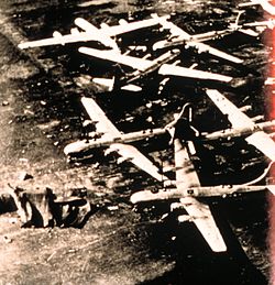
2nd Tinker Air Force Base tornado
F3 tornado
Tinker AFB tornado damage 3.jpg
Damage to airplanes and cars from the March 25 tornado
Max. rating1 F3 tornado
FatalitiesNone
Damage$6 million (1948 USD)
1Most severe tornado damage; see Fujita scale

Although storms were relatively benign up to the point where they reached Tinker, a supercell formed just west of the base, and at around 6 pm a tornado touched down on the base for the second time in six days. [7] This second tornado caused $6 million in damage, or $73 million in 2022 dollars. However, due to precautions enacted because of the tornado forecast, no injuries were reported, and damage totals could have been much higher. [5] [6]

Legacy

The tornado prediction proved to be successful, even if its precision was mostly due to chance. Before this point, the Weather Bureau had a policy against issuing tornado warnings, mainly due to fear of panic by the public, and subsequent complacency if forecasts turned out to be false alarms. [6]

Due to lives and costs saved, Fawbush and Miller continued their tornado forecasts, which verified at quite a high rate over the next three years. [6] At first, they kept their forecasts secret. In the spring and summer of 1949, they issued eighteen forecasts for tornadoes within a 100-square-mile (260 km2) area, and all eighteen proved successful. [6] In the subsequent years, while not explicitly using the word "tornado", the Weather Bureau used the pair's forecasts to predict "severe local storms". [6]

The synoptic pattern which occurred on March 25 later became known as the "Miller type-B" pattern and is recognized as one of the most potent severe weather setups. [8]

See also

Related Research Articles

<span class="mw-page-title-main">Tornado</span> Violently rotating column of air in contact with both the Earths surface and a cumulonimbus cloud

A tornado is a violently rotating column of air that is in contact with both the surface of the Earth and a cumulonimbus cloud or, in rare cases, the base of a cumulus cloud. It is often referred to as a twister, whirlwind or cyclone, although the word cyclone is used in meteorology to name a weather system with a low-pressure area in the center around which, from an observer looking down toward the surface of the Earth, winds blow counterclockwise in the Northern Hemisphere and clockwise in the Southern. Tornadoes come in many shapes and sizes, and they are often visible in the form of a condensation funnel originating from the base of a cumulonimbus cloud, with a cloud of rotating debris and dust beneath it. Most tornadoes have wind speeds less than 180 kilometers per hour, are about 80 meters across, and travel several kilometers before dissipating. The most extreme tornadoes can attain wind speeds of more than 480 kilometers per hour (300 mph), are more than 3 kilometers (2 mi) in diameter, and stay on the ground for more than 100 km (62 mi).

<span class="mw-page-title-main">Tornado warning</span> Weather warning indicating imminent danger of tornadoes

A tornado warning is a public warning that is issued by weather forecasting agencies to an area in the direct path of a tornado or a thunderstorm that is capable of producing a tornado. Modern weather surveillance technology such as Doppler weather radar allow for early detection of rotation in a thunderstorm, and for subsequent warnings to be issued before a tornado actually develops. It is nevertheless still not uncommon that warnings are issued based on reported visual sighting of a tornado, funnel cloud, or wall cloud, typically from weather spotters or the public, but also law enforcement or local emergency management. In particular, a tornado can develop in a gap of radar coverage, of which there are several known in the United States.

<span class="mw-page-title-main">Tornado watch</span> Weather watch indicating conditions favorable for tornado development in severe thunderstorms

A tornado watch is a severe weather watch product of the National Weather Service that is issued by national weather forecasting agencies when meteorological conditions are favorable for the development of severe thunderstorms capable of producing tornadoes. In addition to the potential for tornado development, thunderstorms that develop within the watch area may contain large hail, straight-line winds, intense rainfall and/or flooding that pose a similar damage risk as the attendant tornado threat. A tornado watch does not mean a tornado is active or will appear, just that favorable conditions increases the likelihood of such happening. A watch must not be confused with a tornado warning.

<span class="mw-page-title-main">Severe thunderstorm watch</span> Weather watch indicating conditions favorable for the development of severe thunderstorms

A severe thunderstorm watch is a statement issued by weather forecasting agencies to advise the public that atmospheric conditions in a given region may lead to the development of severe thunderstorms within the region over several hours. The criteria for issuing a watch varies from country to country and may also include torrential rainfall and tornadoes. A watch may also be issued several hours ahead of the arrival of a mature and organized complex of storms, such as a mesoscale convective system.

<span class="mw-page-title-main">National Weather Service</span> U.S. forecasting agency of the National Oceanic and Atmospheric Administration

The National Weather Service (NWS) is an agency of the United States federal government that is tasked with providing weather forecasts, warnings of hazardous weather, and other weather-related products to organizations and the public for the purposes of protection, safety, and general information. It is a part of the National Oceanic and Atmospheric Administration (NOAA) branch of the Department of Commerce, and is headquartered in Silver Spring, Maryland, within the Washington metropolitan area. The agency was known as the United States Weather Bureau from 1890 until it adopted its current name in 1970.

<span class="mw-page-title-main">Tri-State tornado outbreak</span> 1925 tornado outbreak in the U.S. states of Missouri, Illinois, and Indiana

On March 18, 1925, one of the deadliest tornado outbreaks in recorded history generated at least twelve significant tornadoes and spanned a large portion of the midwestern and southern United States. In all, at least 751 people were killed and more than 2,298 were injured, making the outbreak the deadliest tornado outbreak, March 18 the deadliest tornado day, and 1925 the deadliest tornado year in U.S. history. The outbreak generated several destructive tornadoes in Missouri, Illinois, and Indiana on the same day, as well as significant tornadoes in Alabama and Kansas. In addition to confirmed tornadoes, there were undoubtedly others with lesser impacts, the occurrences of which have been lost to history.

<span class="mw-page-title-main">1965 Palm Sunday tornado outbreak</span> Natural disaster in the US

On April 10–12, 1965, a devastating multiple-vortex tornado affected the Midwestern and Southeastern United States. The tornado outbreak produced 55 confirmed tornadoes in one day and 16 hours. The worst part of the outbreak occurred during the afternoon hours of April 11 into the overnight hours going into April 12. The second-largest tornado outbreak on record at the time, this deadly series of tornadoes, which became known as the 1965 Palm Sunday tornado outbreak, inflicted a swath of destruction from Cedar County, Iowa, to Cuyahoga County, Ohio, and a swath 450 miles long (724 km) from Kent County, Michigan, to Montgomery County, Indiana. The main part of the outbreak lasted 16 hours and 35 minutes and is among the most intense outbreaks, in terms of tornado strength, ever recorded, including at least four "double/twin funnel" tornadoes. In all, the outbreak killed 266 people, injured 3,662 others, and caused $1.217 billion in damage.

<span class="mw-page-title-main">1999 Oklahoma tornado outbreak</span> Tornado outbreak in May 1999

The 1999 Oklahoma tornado outbreak was a significant tornado outbreak that affected much of the Central and parts of the Eastern United States, with the highest record-breaking wind speeds of 301 ± 20 mph (484 ± 32 km/h). During this week-long event, 154 tornadoes touched down. More than half of them were on May 3 and 4 when activity reached its peak over Oklahoma, Kansas, Nebraska, Texas, and Arkansas.

<span class="mw-page-title-main">Tornado records</span> List of world records related to tornadoes

This article lists various tornado records. The most "extreme" tornado in recorded history was the Tri-State tornado, which spread through parts of Missouri, Illinois, and Indiana on March 18, 1925. It is considered an F5 on the Fujita Scale, even though tornadoes were not ranked on any scale at the time. It holds records for longest path length at 219 miles (352 km), longest duration at about 3+12 hours, and it held the fastest forward speed for a significant tornado at 73 mph (117 km/h) anywhere on Earth until 2021. In addition, it is the deadliest single tornado in United States history with 695 fatalities. It was also the third most costly tornado in history at the time, but has been surpassed by several others when non-normalized. When costs are normalized for wealth and inflation, it still ranks third today.

<span class="mw-page-title-main">Storm Prediction Center</span> American severe weather forecasting center

The Storm Prediction Center (SPC) is a US government agency that is part of the National Centers for Environmental Prediction (NCEP), operating under the control of the National Weather Service (NWS), which in turn is part of the National Oceanic and Atmospheric Administration (NOAA) of the United States Department of Commerce (DoC).

<span class="mw-page-title-main">1994 Palm Sunday tornado outbreak</span>

The 1994 Palm Sunday tornado outbreak was the third notable US tornado outbreak to occur on Palm Sunday and the second to take place in the Southeastern United States. The outbreak produced 29 tornadoes from Texas to North Carolina, killing 40 people and injuring 491, and causing $140 million in damage. The deadliest storm of the outbreak, as well as in the US in 1994, was an F4 tornado that devastated Piedmont, Alabama. It struck the Goshen United Methodist Church right in the middle of the Palm Sunday service, collapsing the roof on the congregation and killing 20 people inside, including the Rev. Kelly Clem's 4-year-old daughter Hannah. Two other houses of worship were also destroyed mid-service. The supercell that formed this tornado tracked for 200 miles (322 km) to South Carolina.

<span class="mw-page-title-main">Robert C. Miller</span>

Col. Robert C. Miller, USAF (1920–1998), was an American meteorologist, who pioneered severe convective storms forecasting and applied research, developing an empirical forecasting method, identifying many features associated with severe thunderstorms, a forecast checklist and manuals, and is known for the first official tornado forecast, and it verified, in 1948.

<span class="mw-page-title-main">1920 Palm Sunday tornado outbreak</span> 1920 windstorm in the Midwest and Southern United States

On March 28, 1920, a large outbreak of at least 37 tornadoes, 31 of which were significant, took place across the Midwestern and Southern United States. The tornadoes left at least 153 dead and at least 1,215 injured. Many communities and farmers alike were caught off-guard as the storms moved to the northeast at speeds that reached over 60 mph (97 km/h). Most of the fatalities occurred in Georgia (37), Ohio (28), and Indiana (21), while the other states had lesser totals. Little is known about many of the specific tornadoes that occurred, and the list below is only partial.

Joseph G. Galway, was an American meteorologist pioneering in the fields of severe convective storm forecasting and research. He was one of the first forecasters for the Severe Local Storms Unit and the National Severe Storms Forecast Center, and developed widely used synoptic predictors associated with severe thunderstorms and tornadoes, such as the jet streak and lifted index.

<span class="mw-page-title-main">Tornado outbreak sequence of May 2003</span>

From May 3 to May 11, 2003, a prolonged and destructive series of tornado outbreaks affected much of the Great Plains and Eastern United States. Most of the severe activity was concentrated between May 4 and May 10, which saw more tornadoes than any other week-long span in recorded history; 335 tornadoes occurred during this period, concentrated in the Ozarks and central Mississippi River Valley. Additional tornadoes were produced by the same storm systems from May 3 to May 11, producing 363 tornadoes overall, of which 62 were significant. Six of the tornadoes were rated F4, and of these four occurred on May 4, the most prolific day of the tornado outbreak sequence; these were the outbreak's strongest tornadoes. Damage caused by the severe weather and associated flooding amounted to US$4.1 billion, making it the costliest U.S. tornado outbreak of the 2000s. A total of 50 deaths and 713 injuries were caused by the severe weather, with a majority caused by tornadoes; the deadliest tornado was an F4 that struck Madison and Henderson counties in Tennessee, killing 11.

<span class="mw-page-title-main">1999 Bridge Creek–Moore tornado</span> 1999 tornado in Oklahoma, US

The 1999 Bridge Creek–Moore tornado was a large and exceptionally powerful F5 tornado in which the highest wind speeds ever measured globally were recorded at 301 ± 20 miles per hour (484 ± 32 km/h) by a Doppler on Wheels (DOW) radar. Considered the strongest tornado ever recorded to have affected the metropolitan area, the tornado devastated southern portions of Oklahoma City, Oklahoma, United States, along with surrounding suburbs and towns to the south and southwest of the city during the early evening of Monday, May 3, 1999. At peak or near peak intensity, the tornado devastated southern portions of Oklahoma City, Oklahoma, along with surrounding suburbs and towns to the south and southwest. Parts of Bridge Creek were rendered unrecognizable. The tornado covered 38 miles (61 km) during its 85-minute existence, destroying thousands of homes, killing 36 people, and leaving US$1 billion in damage, ranking it as the fifth-costliest on record not accounting for inflation. Its severity prompted the first-ever use of the tornado emergency statement by the National Weather Service.

On December 18–20, 1957, a significant tornado outbreak sequence affected the southern Midwest and the South of the contiguous United States. The outbreak sequence began on the afternoon of December 18, when a low-pressure area approached the southern portions of Missouri and Illinois. Supercells developed and proceeded eastward at horizontal speeds of 40 to 45 miles per hour, yielding what was considered the most severe tornado outbreak in Illinois on record so late in the calendar year. Total losses in the state were estimated to fall within the range of $8–$10 million.

<span class="mw-page-title-main">National Weather Service Norman, Oklahoma</span> Weather Forecast Office of the National Weather Service

National Weather Service - Norman, Oklahoma is a Weather Forecast Office (WFO) of the National Weather Service based in Norman, Oklahoma, which is responsible for forecasts and the dissemination of weather warnings and advisories for central and most of western Oklahoma, and western portions of north Texas. It is located in the National Weather Center on the University of Oklahoma campus, where it acts as one of the NOAA Weather Partners, a group of close-together weather-related agencies of the National Oceanic and Atmospheric Administration. NWS Norman is currently overseen by Mark Fox, who serves as the Meteorologist In Charge of the office.

<span class="mw-page-title-main">Larry Wilson (meteorologist)</span> American meteorologist

Larry F. Wilson is an American meteorologist who specializes in the forecasting of severe convective storms. For many years Wilson served as a lead forecaster at the National Severe Storms Forecast Center in Kansas City, Missouri. As a U.S. Air Force (USAF) meteorologist in the mid-1960s, Wilson is one of only two NSSFC forecasters to have ever worked directly with severe weather forecasting pioneer Colonel Robert C. Miller (1920-1998).

References

  1. 1 2 3 Grice, G. K.; Trapp, R. J.; Corfidi, S. F.; Davies-Jones, R.; Buonanno, C. C.; Craven, J. P.; Droegemeier, K. K.; Duchon, C.; Houghton, J. V.; Prentice, R. A.; Romine, G.; Schlachter, K.; Wagner, K. K. (July 1999). "The Golden Anniversary Celebration of the First Tornado Forecast" (PDF). Bulletin of the American Meteorological Society . Boston: American Meteorological Society. 80 (7): 1341–1348. Bibcode:1999BAMS...80.1341G. doi:10.1175/1520-0477(1999)080<1341:TGACOT>2.0.CO;2. S2CID   123670476. Archived (PDF) from the original on May 30, 2009. Retrieved July 12, 2009.
  2. Grazulis 1993 , p. 935
  3. Grazulis 2001 , p. 131
  4. Branick, Michael L. (December 22, 2008). "Tornadoes in the Oklahoma City, Oklahoma Area Since 1890". Norman, Oklahoma: National Weather Service. Archived from the original on June 30, 2009. Retrieved July 12, 2009.
  5. 1 2 3 4 5 6 7 Miller, Col. Robert C. "Description of Historical Events Relating to Tornado Forecasting in the Late 1940s and Early 1950s". The Unfriendly Sky. National Severe Storms Laboratory. Archived from the original on February 23, 1999. Retrieved July 12, 2009.
  6. 1 2 3 4 5 6 7 McDermott, Pat (July 28, 1951). "Flash-Tornado Warning!". The Saturday Evening Post. pp. 17–19, 53–57. Archived from the original on October 2, 1999. Retrieved July 12, 2009.
  7. Grazulis 2001 , pp. 85–88
  8. Maddox, Robert A.; Crisp, Charlie A. (August 1999). "The Tinker AFB Tornadoes of March 1948". Weather and Forecasting . American Meteorological Society. 14 (4): 492–499. Bibcode:1999WtFor..14..492M. doi:10.1175/1520-0434(1999)014<0492:TTATOM>2.0.CO;2.

Bibliography