
In meteorology, a cyclone is a large air mass that rotates around a strong center of low atmospheric pressure, counterclockwise in the Northern Hemisphere and clockwise in the Southern Hemisphere as viewed from above. Cyclones are characterized by inward-spiraling winds that rotate about a zone of low pressure. The largest low-pressure systems are polar vortices and extratropical cyclones of the largest scale. Warm-core cyclones such as tropical cyclones and subtropical cyclones also lie within the synoptic scale. Mesocyclones, tornadoes, and dust devils lie within the smaller mesoscale.

A subtropical cyclone is a weather system that has some characteristics of both tropical and extratropical cyclones.

In meteorology, a low-pressure area, low area or low is a region where the atmospheric pressure is lower than that of surrounding locations. It is the opposite of a high-pressure area. Low-pressure areas are commonly associated with inclement weather, while high-pressure areas are associated with lighter winds and clear skies. Winds circle anti-clockwise around lows in the northern hemisphere, and clockwise in the southern hemisphere, due to opposing Coriolis forces. Low-pressure systems form under areas of wind divergence that occur in the upper levels of the atmosphere (aloft). The formation process of a low-pressure area is known as cyclogenesis. In meteorology, atmospheric divergence aloft occurs in two kinds of places:

The 1997 Atlantic hurricane season was a below-average hurricane season. It officially began on June 1, and lasted until November 30 of that year. These dates conventionally delimit the period of each year when most tropical cyclones form in the Atlantic basin. The 1997 season was fairly inactive, with only seven named storms forming, with an additional tropical depression and an unnumbered subtropical storm. It was the first time since the 1961 season that there were no active tropical cyclones in the Atlantic basin during the entire month of August—historically one of the more active months of the season—a phenomenon that would not occur again until 2022. A strong El Niño is credited with reducing activity in the Atlantic, while increasing the number of storms in the eastern and western Pacific basins to 19 and 26 storms, respectively. As is common in El Niño years, tropical cyclogenesis was suppressed in the tropical latitudes, with only two becoming tropical storms south of 25°N.

The westerlies, anti-trades, or prevailing westerlies, are prevailing winds from the west toward the east in the middle latitudes between 30 and 60 degrees latitude. They originate from the high-pressure areas in the horse latitudes and trend towards the poles and steer extratropical cyclones in this general manner. Tropical cyclones which cross the subtropical ridge axis into the westerlies recurve due to the increased westerly flow. The winds are predominantly from the southwest in the Northern Hemisphere and from the northwest in the Southern Hemisphere.

A tropical wave, in and around the Atlantic Ocean, is a type of atmospheric trough, an elongated area of relatively low air pressure, oriented north to south, which moves from east to west across the tropics, causing areas of cloudiness and thunderstorms. Tropical waves form in the easterly flow along the equatorial side of the subtropical ridge or belt of high air pressure which lies north and south of the Intertropical Convergence Zone (ITCZ). Tropical waves are generally carried westward by the prevailing easterly winds along the tropics and subtropics near the equator. They can lead to the formation of tropical cyclones in the north Atlantic and northeastern Pacific basins. A tropical wave study is aided by Hovmöller diagrams, a graph of meteorological data.

The 1951 Atlantic hurricane season was the first hurricane season in which tropical cyclones were officially named by the United States Weather Bureau. The season officially started on June 15, when the United States Weather Bureau began its daily monitoring for tropical cyclone activity; the season officially ended on November 15. It was the first year since 1937 in which no hurricanes made landfall on the United States; as Hurricane How was the only tropical storm to hit the nation, the season had the least tropical cyclone damage in the United States since the 1939 season. As in the 1950 season, names from the Joint Army/Navy Phonetic Alphabet were used to name storms this season.

Cyclogenesis is the development or strengthening of cyclonic circulation in the atmosphere. Cyclogenesis is an umbrella term for at least three different processes, all of which result in the development of some sort of cyclone, and at any size from the microscale to the synoptic scale.

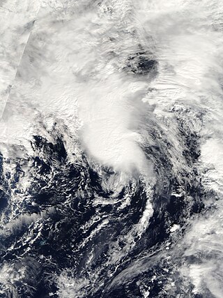
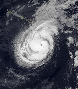
Tropical Storm Gilda in 1973 was the first documented tropical cyclone on record to transition into a subtropical cyclone. It formed on October 16 in the western Caribbean Sea from a tropical wave, and strengthened to reach peak winds of 70 mph (110 km/h) before striking Cuba. It later moved slowly through the Bahamas before weakening to tropical depression status. On October 24, with the assistance of a cold front off the coast of the eastern United States, Gilda transformed into a subtropical storm, becoming very large and strong. The storm later accelerated northeastward and became extratropical, ultimately dissipating near Greenland.

Hurricane Gustav was a Category 2 hurricane that paralleled the East Coast of the United States in September 2002 during the 2002 Atlantic hurricane season. It was the seventh named storm and first hurricane of the season. Initially a subtropical depression north of the Bahamas, Gustav passed just to the east of the Outer Banks, North Carolina as a tropical storm before traveling northeastward, making two landfalls in Atlantic Canada as a Category 1 hurricane. The storm was responsible for one death and $100,000 in damage, mostly in North Carolina. The interaction between Gustav and a non-tropical system produced strong winds that caused an additional $240,000 (2002 USD) in damage in New England, but this damage was not directly attributed to the hurricane.
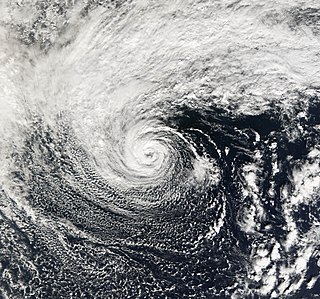
Subtropical Storm Nicole was the first subtropical storm to receive a name using the standard hurricane name list that did not become a tropical cyclone. The fifteenth tropical or subtropical cyclone and fourteenth named storm of the 2004 Atlantic hurricane season, Nicole developed on October 10 near Bermuda from a broad surface low that developed as a result of the interaction between an upper level trough and a decaying cold front. The storm turned to the northeast, passing close to Bermuda as it intensified to reach peak winds of 50 mph (80 km/h) on October 11. Deep convection developed near the center of the system as it attempted to become a fully tropical cyclone. However, it failed to do so and was absorbed by an extratropical cyclone late on October 11.
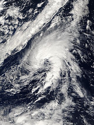
The 2005 Azores subtropical storm was the 19th nameable storm and only subtropical storm of the extremely active 2005 Atlantic hurricane season. It was not named by the National Hurricane Center as it was operationally classified as an extratropical low. It developed in the eastern Atlantic Ocean, an unusual region for late-season tropical cyclogenesis. Nonetheless, the system was able to generate a well-defined centre convecting around a warm core on 4 October. The system was short-lived, crossing over the Azores later on 4 October before becoming extratropical again on 5 October. No damages or fatalities were reported during that time. Its remnants were soon absorbed into a cold front. That system went on to become Hurricane Vince, which affected the Iberian Peninsula.
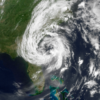
Subtropical Storm Andrea was the first named storm to form in May in the Atlantic Ocean in 26 years. Andrea caused large waves and tropical-storm force winds along the southeast coast of the United States. The first named storm and the first subtropical cyclone of the 2007 Atlantic hurricane season, Andrea developed out of a non-tropical low on May 9 about 150 miles (240 km) northeast of Daytona Beach, Florida, three weeks before the official start of the season. After encountering dry air and strong vertical wind shear, Andrea weakened to a subtropical depression on May 10 while remaining nearly stationary, and the National Hurricane Center discontinued advisories early on May 11. Andrea's remnant was subsequently absorbed into another extratropical storm on May 14. Andrea was the first pre-season storm to develop since Tropical Storm Ana in April 2003. Additionally, the storm was the first Atlantic named storm in May since Tropical Storm Arlene in 1981.
The 2006 Central Pacific cyclone, also known as Invest 91C or Storm 91C, was an unusual weather system that formed in 2006. Forming on October 30 from a mid-latitude cyclone in the north Pacific mid-latitudes, it moved over waters warmer than normal. The system acquired some features more typical of subtropical and even tropical cyclones. However, as it neared the western coastline of North America, the system fell apart, dissipating soon after landfall, on November 4. Moisture from the storm's remnants caused substantial rainfall in British Columbia and the Pacific Northwest. The exact status and nature of this weather event is unknown, with meteorologists and weather agencies having differing opinions.

The U.S. state of Hawaiʻi, which covers the Hawaiian Islands, is tropical but it experiences many different climates, depending on altitude and surroundings. The island of Hawaiʻi for example hosts four climate groups on a surface as small as 4,028 square miles (10,430 km2) according to the Köppen climate types: tropical, arid, temperate and polar. When counting also the Köppen sub-categories – notably including the very rare cold-summer mediterranean climate – the island of Hawaiʻi hosts 10 climate zones. The islands receive most rainfall from the trade winds on their north and east flanks as a result of orographic precipitation. Coastal areas are drier, especially the south and west side or leeward sides.

The November 2014 Bering Sea cyclone was the most intense extratropical cyclone ever recorded in the Bering Sea, which formed from a new storm developing out of the low-level circulation that separated from Typhoon Nuri, which soon absorbed the latter. The cyclone brought gale-force winds to the western Aleutian Islands and produced even higher gusts in other locations, including a 97 miles per hour (156 km/h) gust in Shemya, Alaska. The storm coincidentally occurred three years after another historic extratropical cyclone impacted an area slightly further to the east.

The October 2017 nor'easter was a major explosive cyclogenesis storm, also called a bomb cyclone, in the Northeastern United States and Atlantic Canada from October 29–31, 2017. Forming from an extratropical cyclone on October 29 the system moved rapidly up the East Coast of the United States, bombing out with a minimum pressure of 975 millibars (28.8 inHg) on October 30. It brought heavy rain and extremely strong winds, and power outages, over 1.3 million customers being without power in the Northeast. Hurricane-force wind gusts resulted in downed trees, power lines, and widespread damage to buildings. The number of power outages in the state of Maine surpassed the Ice Storm of 1998.
Hurricane Hone was a fairly long-lived tropical cyclone that impacted the U.S. state of Hawaii in August 2024. The eighth named storm and third hurricane of the 2024 Pacific hurricane season, Hone was also the first tropical cyclone to form in the North Central Pacific tropical cyclone basin since 2019. Hone developed from two disturbances that formed over the northeastern Pacific Ocean in late August 2024. The two disturbances eventually merged into a larger area of disturbed weather on August 20. The merged system steadily became more organized, and the development of persistent deep convection over its center led to its designation as Tropical Depression One-C on August 22. The depression strengthened into a tropical storm six hours later and was named Hone. Hone gradually strengthened as it approached Hawaii from the southeast. On August 25, Hone strengthened into a hurricane while located just south of Hawaii's Big Island. After passing near the islands with maximum sustained winds of 85 mph (140 km/h), Hone began to weaken as it continued westward away from Hawaii, and the Central Pacific Hurricane Center ultimately designated Hone as a post-tropical low near the International Date Line on September 1. However, the system continued to be monitored by the Japan Meteorological Agency and Joint Typhoon Warning Center, which designated Hone a tropical and subtropical depression, respectively, in the Western Pacific, until the storm dissipated several days later.

