Lacey V. Murrow Memorial Bridge

Last updated

Lacey V. Murrow Memorial Bridge
I-90 floating bridges looking east.JPG
The Lacey V. Murrow Memorial Bridge (right) and the Homer M. Hadley Memorial Bridge (left) in 2005, looking east toward Mercer Island
Coordinates 47°35′24″N122°16′12″W / 47.5899°N 122.27°W / 47.5899; -122.27
CarriesI-90.svg I-90, eastbound lanes
Crosses Lake Washington
Locale Seattle / Mercer Island, Washington, U.S.
Maintained by Washington State Department of Transportation
Characteristics
Design Pontoon bridge
Total length6,620 ft (2,020 m)
History
OpenedJuly 2, 1940
RebuiltSeptember 12, 1993
Location
Lacey V. Murrow Memorial Bridge

The Lacey V. Murrow Memorial Bridge is a floating bridge in the Seattle metropolitan area of the U.S. state of Washington. It is one of the Interstate 90 floating bridges that carries the eastbound lanes of Interstate 90 across Lake Washington from Seattle to Mercer Island. Westbound traffic is carried by the adjacent Homer M. Hadley Memorial Bridge.

Contents

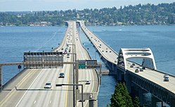
The Murrow Bridge is the second-longest floating bridge in the world, at 6,620 ft (2,020 m) (the longest is the Governor Albert D. Rosellini Bridge–Evergreen Point, a few miles north on the same lake). The original Murrow Bridge opened in 1940, and was named the Lake Washington Floating Bridge. It was renamed the Lacey V. Murrow bridge in 1967. [1] The original bridge closed in 1989; [2] [3] the current bridge opened in 1993. [4]

Along with the east portals of the Mount Baker Ridge Tunnel, the bridge is an official City of Seattle landmark and a National Historic Civil Engineering Landmark. [5] [6] While the bridge originally had an opening span at the center of the bridge to allow a horizontal opening of 202 feet (62 m) for major waterborne traffic, the only boat passages currently are elevated fixed spans at the termini with 29 feet (8.8 m) of vertical clearance. [7]

History

Construction of the bridge; photo taken one year after start of construction. Lacey V. Murrow Bridge construction.jpg
Construction of the bridge; photo taken one year after start of construction.

The bridge was the brainchild of engineer Homer Hadley, who had made the first proposal in 1921. [8] The bridge came about after intensive lobbying, particularly by George Lightfoot, who came to be called the "father of the bridge." Lightfoot began campaigning for the bridge in 1930, enlisting the support of Miller Freeman. [9] [10] [11] Construction began January 1, 1939 and was completed in 1940. [12] The construction cost for the project, including approaches, was approximately $9 million. It was partially financed by a bond issue of $4.184 million. [7] Opened July 2, 1940, the bridge carried US 10 (later decommissioned and renamed Interstate 90). Tolls were removed in 1949. [13] The bridge sank in a storm on November 25, 1990 during refurbishment and repair. [14] The current bridge was built in 1993. The eponymous Lacey V. Murrow (1904–1966) was the second director of the Washington State Highway Department and a highly decorated U.S. Air Force officer who served as a bomber pilot in World War II, rising to the rank of brigadier general. [15] [16] [17] A 1925 graduate of Washington State College in Pullman, he was the oldest brother of CBS commentator Edward R. Murrow. [17]

The original bridge was built under a 1+12-year contract awarded to the Puget Sound Bridge and Dredging Company in the amount of $3.254 million. [18] It included a movable span that could be retracted into a pocket in the center of the fixed span to permit large boats to pass. This design resulted in a roadway bulge that required vehicles to swerve twice across polished steel joints as they passed the bulge. A reversible lane system, indicated by lighted overhead lane control signals with arrow and 'X' signs, compounded the hazard by putting one lane of traffic on the "wrong" side of the bulge during morning and evening rush hours in an effort to alleviate traffic into or out of Seattle. There were many serious collisions on the bridge. The problems grew worse as the traffic load increased over the years and far outstripped the designed capacity. Renovation or replacement became essential and a parallel bridge, the Homer M. Hadley Memorial Bridge, was completed in 1989, and named for Hadley in 1993.

With the opening of the new bridge, the 49-year-old Murrow Bridge closed on June 23, 1989, for renovation that was projected to take three years. [19] [20] [21]

1990 disaster

View northeast of bridge, west approach and Mount Baker Tunnel Murrow Memorial Bridge 07747.JPG
View northeast of bridge, west approach and Mount Baker Tunnel

On November 25, 1990, while under re-construction, the original bridge sank because of a series of human errors and decisions. The process started because the bridge needed resurfacing and was to be widened by means of cantilevered additions in order to meet the necessary lane-width specifications of the Interstate Highway System. The Washington State Department of Transportation (WSDOT) decided to use hydrodemolition (high-pressure water) to remove unwanted material (the sidewalks on the bridge deck). Water from this hydrodemolition was considered contaminated under environmental law and could not be allowed to flow into Lake Washington. [22] Engineers then analyzed the pontoons of the bridge, and realized that they were over-engineered and the water could be stored temporarily in the pontoons. The watertight doors for the pontoons were therefore removed.

A large storm on November 22–24 (the Thanksgiving holiday weekend), [23] filled some of the pontoons with rain and lake water. On Saturday, November 24, workers noticed that the bridge was about to sink, and started pumping out some of the pontoons; on Sunday, November 25, a 2,790-foot (850 m) section of the bridge sank, dumping the contaminated water into the lake along with tons of bridge material. It sank when one pontoon filled and dragged the rest down, because they were cabled together and there was no way to separate the sections under load. No one was hurt or killed, since the bridge was closed for renovation and the sinking took some time. [2] [3] All of the sinking was captured on film and shown on live TV. The cost of the disaster was $69 million in damages. A dozen anchoring cables for the new Hadley bridge were severed, [19] [24] and it was closed for a short time afterward. [25] Westbound traffic was allowed on Tuesday, [26] and eastbound traffic was resumed in early December. [27]

The disaster delayed the bridge's reopening by 14 months, to September 12, 1993. [4] [28]

Precedents and lessons learned

WSDOT had lost another floating bridge, the Hood Canal Bridge, in February 1979 under similar circumstances. It is now known that the other major floating bridge in Washington, the Evergreen Point Floating Bridge, was under-engineered for local environmental conditions; that 1963 bridge was replaced with a new floating span in 2016. [29]

See also

Notes

  1. Lange, G. (1999). Lake Washington Floating Bridge is dedicated on July 2, 1940. Washington State Department of Transportation. http://www.historylink.org/File/682
  2. 1 2 Costello, Nancy (November 26, 1990). "Flood waters send bridge to bottom". Lewiston Morning Tribune. Associated Press. p. 1A.
  3. 1 2 "Floating bridge collapses after storm hits". Spokesman-Review. Associated Press. November 26, 1990. p. A1.
  4. 1 2 "Floating bridge opens". Spokesman-Review. Associated Press. September 13, 1993. p. A12.
  5. Landmarks Alphabetical Listing for L Archived July 21, 2011, at the Wayback Machine , Individual Landmarks, Department of Neighborhoods, City of Seattle. Accessed December 28, 2007.
  6. Witcher, T.R. (September 2018). "Success in Seattle: The Lacey V. Murrow Memorial Bridge and Mount Baker Ridge Tunnel". Civil Engineering. American Society of Civil Engineers. pp. 44–47.
  7. 1 2 Tudor Engineering Company for Washington State Highway Commission Department of Highways. Legislative Reconnaissance and Feasibility Report "Lake Washington Bridge Crossings, Parallel Evergreen Point Bridge, North Lake Bridge. December 1968.
  8. Burrows, Alyssa (January 18, 2005). "Homer Hadley formally proposes a concrete pontoon floating bridge across Lake Washington on October 1, 1921". HistoryLink . Retrieved September 19, 2015.
  9. "G. W. Lightfoot Taken By Death". The Seattle Times . April 18, 1941.
  10. Reynolds, Peggy (May 24, 1989). "George Lightfoot's Vision Spanned Lake Washington" . The Seattle Times. p. H1. Retrieved September 19, 2015 via NewsBank.
  11. Brahm, Jane Meyer (2013). Mercer Island History: From Haunted Wilderness to Coveted Community. Island Books.
  12. Zylstra, Brian (January 28, 2011). "Building the first Lake Washington floating bridge". From Our Corner. Washington Office of the Secretary of State . Retrieved September 19, 2015.
  13. "Floating Bridge Pays For Itself". The Southeast Missourian . Newspaper Enterprise Association. July 19, 1949. p. 3. Retrieved May 18, 2010 via Google News Archive.
  14. "Pontoon Bridge Sinks in Flooding As Seattle Is Battered by Storms". The New York Times . Associated Press. November 26, 1990. Retrieved September 19, 2015.
  15. "Gen. Lacey Murrow found dead in hotel". Spokane Daily Chronicle. December 17, 1966. p. 3.
  16. "Brigadier General Lacey Van Buren Murrow". United States Air Force. (Biographies). Retrieved August 8, 2018.
  17. 1 2 Oldham, Kit (March 16, 2005). "Lacey V. Murrow becomes Director of Highways on March 20, 1933". History Link. (Essay 7278). Retrieved August 8, 2018.
  18. Schmitt, F.E. (January 5, 1939). "Low Bidder Get Contract on Pontoon Bridge". Engineering News-Record. New York: McGraw-Hill Publishing Company. 122 (1): 5. Retrieved December 28, 2008 via Google Books.
  19. 1 2 "Contractor on old bridge goes after big projects". Spokesman-Review. Associated Press. December 1, 1990. p. A8.
  20. Gough, William (June 22, 1989). "That'll be one bridge – to go – The old I-90 closes tomorrow" . The Seattle Times . p. A1. Retrieved May 16, 2018 via NewsBank.
  21. "Eastbound I-90 lanes to close over weekend in shift to new bridge" . The Seattle Post-Intelligencer . June 23, 1989. p. B1. Retrieved May 15, 2018 via NewsBank.
  22. Donald O. Dusenberry, et al. (Feb. 1995). "Failure of Lacey V. Murrow floating bridge, Seattle, Washington." Journal of Performance of Constructed Facilities, v. 9, n. 1, p 4-23.
  23. Cabrera, Luis (November 26, 1990). "Record rains create chaos in parts of western Washington". Lewiston Morning Tribune. Associated Press. p. 6A.
  24. "I-90 bridge opened and shut and..." Spokane Chronicle. Associated Press. November 29, 1990. p. A1.
  25. Costello, Nancy (November 27, 1990). "Surviving I-90 bridge still at mercy of wind". Spokesman-Review. Associated Press. p. A1.
  26. "Crews rush to anchor I-90 bridge". Spokesman-Review. Associated Press. November 28, 1990. p. B1.
  27. Rosenwald, Lonnie (December 3, 1990). "Bridge still creates splash". Spokane Chronicle. p. A6.
  28. "SR 520 - Floating Bridge and Landings Project". Washington State Department of Transportation. Archived from the original on October 16, 2015. Retrieved September 19, 2015.
47°35′24″N122°16′13″W / 47.58988°N 122.27031°W / 47.58988; -122.27031

Related Research Articles

<span class="mw-page-title-main">Mercer Island, Washington</span> City in Washington, United States

Mercer Island is a city in King County, Washington, United States, located on an island of the same name in the southern portion of Lake Washington. Mercer Island is in the Seattle metropolitan area, with Seattle to its west and Bellevue to its east.

<span class="mw-page-title-main">Lake Washington</span> Freshwater lake in the United States

Lake Washington is a large freshwater lake adjacent to the city of Seattle. It is the largest lake in King County and the second largest natural lake in the state of Washington, after Lake Chelan. It borders the cities of Seattle on the west, Bellevue and Kirkland on the east, Renton on the south and Kenmore on the north, and encloses Mercer Island. The lake is fed by the Sammamish River at its north end and the Cedar River at its south.

<span class="mw-page-title-main">Washington State Route 520</span> Freeway in Washington state

State Route 520 (SR 520) is a state highway and freeway in the Seattle metropolitan area, part of the U.S. state of Washington. It runs 13 miles (21 km) from Seattle in the west to Redmond in the east. The freeway connects Seattle to the Eastside region of King County via the Evergreen Point Floating Bridge on Lake Washington. SR 520 intersects several state highways, including Interstate 5 (I-5) in Seattle, I-405 in Bellevue, and SR 202 in Redmond.

<span class="mw-page-title-main">Evergreen Point Floating Bridge (1963)</span> Former highway floating bridge in Seattle, Washington, United States

The Evergreen Point Floating Bridge, officially the Governor Albert D. Rosellini Bridge, and commonly called the SR 520 Bridge or 520 Bridge, was a floating bridge in the U.S. state of Washington that carried State Route 520 across Lake Washington, connecting Medina with the Montlake/Union Bay district of Seattle.

<span class="mw-page-title-main">Eastside (King County, Washington)</span> Suburbs of Seattle located on the east side of Lake Washington

The Eastside of the King County, Washington area in the United States is a collective term for the suburbs of Seattle located on the east side of Lake Washington.

<span class="mw-page-title-main">Hood Canal Bridge</span> Pontoon bridge in western Washington State, United States

The Hood Canal Bridge is a floating bridge in the northwest United States, located in western Washington. It carries State Route 104 across Hood Canal in Puget Sound and connects the Olympic and Kitsap Peninsulas. At 7,869 feet in length, it is the longest floating bridge in the world located in a saltwater tidal basin, and the third longest floating bridge overall. First opened 62 years ago in 1961, it was the second concrete floating bridge constructed in Washington. Since that time, it has become a vital link for local residents, freight haulers, commuters, and recreational travelers. The convenience it provides has had a major impact on economic development, especially in eastern Jefferson County.

<span class="mw-page-title-main">Homer M. Hadley Memorial Bridge</span> Floating bridge in Seattle, Washington, U.S.

The Third Lake Washington Bridge, officially the Homer M. Hadley Memorial Bridge, is a floating bridge in the Seattle metropolitan area of the U.S. state of Washington. It is one of the Interstate 90 floating bridges, carrying the westbound lanes of Interstate 90 across Lake Washington between Mercer Island and Seattle. The floating bridge is the fifth-longest of its kind in the world, at 5,811 feet.

The Washington State Department of Transportation is a governmental agency that constructs, maintains, and regulates the use of transportation infrastructure in the U.S. state of Washington. Established in 1905, it is led by a secretary and overseen by the governor. WSDOT is responsible for more than 20,000 lane-miles of roadway, nearly 3,000 vehicular bridges and 524 other structures. This infrastructure includes rail lines, state highways, state ferries and state airports.

Lake Washington Floating Bridge may refer to the following crossings of Lake Washington between Seattle and its eastern suburbs:

<span class="mw-page-title-main">Retractable bridge</span> Bridge which can slide open

A retractable bridge is a type of moveable bridge in which the deck can be rolled or slid backwards to open a gap while traffic crosses, usually a ship on a waterway. This type is sometimes referred to as a thrust bridge.

<span class="mw-page-title-main">East Channel Bridge</span> Highway bridge between Mercer Island and Bellevue, Washington, United States

The East Channel Bridge is a bridge carrying Interstate 90 from Mercer Island, Washington, to Bellevue, Washington, over the East Channel of Lake Washington, which separates Mercer Island from the rest of the Eastside.

<span class="mw-page-title-main">Mount Baker Tunnel</span> Highway tunnels in Seattle, Washington, United States

The Mount Baker Tunnel or Mount Baker Ridge Tunnel carries Interstate 90 under the Mount Baker neighborhood of Seattle, Washington. It is actually a group of three tubes that carry eight lanes of freeway traffic, plus a separate path for bicycles and pedestrians. The original tubes are twin tunnel bores completed in 1940 and rehabilitated in 1993. The new Mount Baker Tunnel was built north of the original tunnels and opened in June 1989. The tunnel has a double-decked roadway with the bicycle/pedestrian path above the traffic lanes.

The Interstate 90 floating bridges is the common name for the twin floating bridges that carry a section of Interstate 90 across Lake Washington between Seattle and Mercer Island in the U.S. state of Washington. They are the:

<span class="mw-page-title-main">Interstate 90 in Washington</span> Interstate highway in Washington

Interstate 90 (I-90), designated as the American Veterans Memorial Highway, is a transcontinental Interstate Highway that runs from Seattle, Washington, to Boston, Massachusetts. It crosses Washington state from west to east, traveling 298 miles (480 km) from Seattle across the Cascade Mountains and into Eastern Washington, reaching the Idaho state line east of Spokane. I-90 intersects several of the state's other major highways, including I-5 in Seattle, I-82 and U.S. Route 97 (US 97) near Ellensburg, and US 395 and US 2 in Spokane.

<span class="mw-page-title-main">Float (nautical)</span> Flotation device

Floats are airtight hollow structures, similar to pressure vessels, designed to provide buoyancy in water. Their principal applications are in watercraft hulls, aircraft floats, floating pier, pontoon rhinos, pontoon causeways, and marine engineering applications such as salvage.

<span class="mw-page-title-main">Benton City – Kiona Bridge</span> Bridge in United States of America

The Benton City – Kiona Bridge is a steel box girder and cable-stayed bridge carrying two lanes of Washington State Route 225 over the Yakima River in Benton City, Benton County, Washington. The current span was opened to traffic on July 4, 1957 and measures 400-foot-long (121.9 m) by 26-foot (7.8 m) wide. Two bridges had previously connected the cities of Benton City and Kiona before and were located 300 feet (91 m) downstream. The first bridge was open by 1901, and the immediate predecessor bridge was closed and torn down in 1964. The bridge is owned and maintained by the Washington State Department of Transportation, and was added to the Washington Heritage Register on January 25, 2002.

<span class="mw-page-title-main">Evergreen Point Floating Bridge</span> Floating bridge carrying a freeway in Seattle, Washington

The Evergreen Point Floating Bridge, also known as the 520 Bridge and officially the Governor Albert D. Rosellini Bridge, carries Washington State Route 520 across Lake Washington from Seattle to its eastern suburbs. The 7,710-foot-long (2,350 m) floating span is the longest floating bridge in the world, as well as the world's widest measuring 116 feet (35 m) at its midpoint.