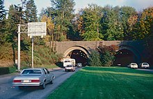
Mount Baker Tunnel

Last updated
Mount Baker Ridge Tunnel
Murrow Memorial Bridge 07747.JPG
View of the Mount Baker Tunnel and the Lacey V. Murrow and Homer M. Hadley Memorial Bridges from the southwest
USA Washington location map.svg
Red pog.svg
LocationI-90.svg I-90, Seattle, Washington
Coordinates 47°35′25″N122°17′55″W / 47.59028°N 122.29861°W / 47.59028; -122.29861 Coordinates: 47°35′25″N122°17′55″W / 47.59028°N 122.29861°W / 47.59028; -122.29861
Built1940 (original; parallel tunnel built 1989)
ArchitectBates & Rogers Construction Corp.
Architectural styleArt Deco
MPS Historic Bridges/Tunnels in Washington State TR
NRHP reference No. 82004243 [1]
Added to NRHPJuly 16, 1982
Aerial view of I-90 in Seattle, including the Mount Baker Tunnel and the two parallel bridges to Mercer Island: the Homer M. Hadley Memorial Bridge (left) and the Lacey V. Murrow Memorial Bridge (right) I-90 bridge-tunnel.jpg
Aerial view of I-90 in Seattle, including the Mount Baker Tunnel and the two parallel bridges to Mercer Island: the Homer M. Hadley Memorial Bridge (left) and the Lacey V. Murrow Memorial Bridge (right)

The Mount Baker Tunnel or Mount Baker Ridge Tunnel carries Interstate 90 under the Mount Baker neighborhood of Seattle, Washington. It is actually a group of three tunnels that carry eight lanes of freeway traffic, plus a separate path for bicycles and pedestrians. The two originals are twin tunnel bores completed in 1940 and rehabilitated in 1993. The newest tunnel was built north of the original tunnels and opened in June 1989. [2] The tunnel has a double-decked roadway with the bicycle/pedestrian path above the traffic lanes.

Contents

The tunnel was listed on the National Register of Historic Places in 1982 (ID #82004243). [1] The east portals of the tunnel, with murals titled Portal of the North Pacific designed by artist James FitzGerald, along with the Lacey V. Murrow Bridge, are an official City of Seattle landmark. [3]

The official length is 1,440 feet (440 m), [4] though the perceived length while driving is closer to 3,300 feet (1,000 m) because of a cut-and-cover "lid" between the western portal and the beginning of the actual tunnel under the Mount Baker ridge. The former west portal, now located well inside the tunnel, is no longer discernible and its two arch structures were removed during 1989–1993 modification work. The eastern end of the tunnel links to the Lacey V. Murrow Memorial Bridge and the Homer M. Hadley Memorial Bridge (collectively the I-90 floating bridge) on Lake Washington, to Mercer Island.

At 63 feet (19 m) in diameter, it is the world's largest diameter soft earth tunnel, having been bored through clay. [4] [5] [6]

Configuration

Original

When completed in 1940, the twin tunnels connected the I-90 floating bridge on Lake Washington and Rainier Avenue South in Seattle. The bridge and tunnels were part of US Highway 10, which used surface streets between the tunnels and downtown Seattle. US 10 was a four-lane, undivided highway. Each tunnel held two traffic lanes. The north tunnel normally carried two westbound lanes. The south tunnel normally carried two eastbound lanes. In the 1960s, a lane-use signal system was added to improve peak commute traffic. During peak commute times, the signals were used to make the center two lanes reversible. In the mornings, three lanes flowed west and one lane flowed east. In the evenings, three lanes flowed east and one lane flowed west. During morning and evening commutes, one tunnel carried two lanes of traffic in the same direction while the other tunnel carried opposing traffic separated only by dashed yellow lines.

The highway would later become part of Interstate 90, be expanded, and upgraded to a controlled-access freeway. The freeway expansion and upgrade was completed in 1993.

1983–1993 expansion

The expansion included construction of a new, parallel tunnel with a larger diameter, located north of the original tunnel. Construction began in 1983. [7] When the overall I-90 project was completed in 1993, the twin 1940 tunnels would be connected to the southern I-90 floating bridge (the Lacey V. Murrow Memorial Bridge) and carry eastbound traffic only, while the 1989 tunnel would be connected to the northern floating bridge (the then-new Homer M. Hadley Memorial Bridge) and be westbound-only for general traffic.

The original pair of tunnels were each 29 feet (8.8 m) in diameter, while the new tunnel was 63 feet (19 m) in diameter. [8] The new tunnel was built to carry traffic on three levels: two lanes for buses and carpools on the bottom level, three lanes of general traffic on the middle level, and cyclists and pedestrians on the top level. [8] Excavation was completed in 1986, and the new tunnel opened to traffic in June 1989. [7] Although designed to carry only westbound traffic, the new tunnel and then-new Homer Hadley Memorial Bridge temporarily carried all traffic – in both directions – when opened in 1989, while work continued on modifying the old Mercer Island Bridge where it connected to the 1940 Murrow Bridge and on rehabilitation of the latter. [7]

The new tunnel opened to westbound traffic on June 4, 1989, and to eastbound traffic on June 23. [9] On the latter date, the old tunnel and floating bridge closed to all traffic, for renovation that was originally expected to take three years. [9] [10] When a long section of the Murrow Bridge sank during a storm in 1990, the reopening was delayed by about one year, until 1993. [11] [12]

The former west portal in 1982. This afternoon-rush-hour view shows the reversible lanes in use, with one westbound lane and three eastbound. Former west portal of Mt. Baker Ridge Tunnel in 1982.jpg
The former west portal in 1982. This afternoon-rush-hour view shows the reversible lanes in use, with one westbound lane and three eastbound.

With the reopening of the Murrow Bridge in 1993, the older Mount Baker Ridge tunnel also reopened, with all of its lanes now eastbound-only. [11] Instead of carrying two traffic lanes in each tunnel, the reconfigured lanes in the twin 1940 tunnels comprised two lanes of eastbound traffic in the northern tunnel and one lane of eastbound traffic in the southern tunnel, [11] and with pedestrians no longer permitted [13] (because of the exclusive pedestrian and bicycle facilities now provided in the parallel new tunnel). A second eastbound lane was later reinstated in the northern tunnel. The reversible lanes in the older tunnels had been separated only by painted lines on the roadway surface, but the reversible lanes on the rebuilt and expanded freeway (which use only the newer, 1989 tunnel) are separated by concrete barriers, to improve safety. [7]

The I-90 expansion project also effectively more than doubled the length of the Mt. Baker Tunnel. [11] The west portal of the twin 1940 tunnels, which had been located near 29th Avenue South, was removed, [13] :8 and a 2,000-foot-long (610 m) concrete "lid" was built over the freeway, [11] covering the section between the old west portal and west end of the lid, just west of 23rd Avenue South. [14] However, officially the lid is not considered to be part of the tunnel, and a 1993 Historic American Engineering Record survey stated that the lengths of the two 1940 tunnels remain 1,466 feet (447 m) each. [13] Inside the older tunnels, which had been arch-shaped, the ceiling and walls were made square, matching the shape of the "lidded" section. Equipment to boost radio reception was added. [11]

Current

Eastern portal of 1989 tunnel Seattle - Portal to the Pacific 01.jpg
Eastern portal of 1989 tunnel
Cross section of 1989 tunnel. Top to bottom: pedestrian and bicycle trail, westbound motor vehicle traffic, buses and carpools (now being converted to carry Link light rail, exclusively). Cross section mount baker tunnel 3rd tube.png
Cross section of 1989 tunnel. Top to bottom: pedestrian and bicycle trail, westbound motor vehicle traffic, buses and carpools (now being converted to carry Link light rail, exclusively).

Upon completion of the Interstate 90 expansion program in the 1990s, the freeway capacity increased to three general-purpose lanes in each direction and two reversible HOV lanes. Eastbound traffic uses the original tunnels. Westbound traffic uses the upper deck of the northern new tunnel. A two-lane reversible roadway uses the lower deck. The reversible roadway served as express lanes for transit buses and carpools (2+ people) during peak commute periods until 2017. The express lanes flowed westbound on weekday mornings and eastbound on weekday afternoons and evenings. On weekends, the express lanes were open; traffic direction was variable depending on anticipated traffic volumes. When the express lanes were open to eastbound traffic, single-occupant vehicles headed to Mercer Island are allowed to use the lanes per an inter-local agreement signed in 1976.

Above the westbound traffic is the I-90 Trail tunnel. At 1,330 feet (410 m), it is the longest non-adapted trail tunnel in the world. On the western half, the trail emerges onto the lid and uses trails in Lid Park. [15]

In 2017, the Washington State Department of Transportation added a pair of high-occupancy vehicle lanes (HOV lanes) to Interstate 90 from Seattle to Bellevue, replacing the reversible express lanes. The express lanes were closed in June 2017 for the construction of the East Link light rail project, which will extend Link light rail service from Seattle to Bellevue and Redmond in 2023. On Mercer Island, WSDOT and Sound Transit are building direct access ramps to allow buses and HOVs to exit and enter I-90 from the HOV lanes.

See also

Related Research Articles

<span class="mw-page-title-main">Washington State Route 520</span> Freeway in Washington state

State Route 520 (SR 520) is a state highway and freeway in the Seattle metropolitan area, part of the U.S. state of Washington. It runs 13 miles (21 km) from Seattle in the west to Redmond in the east. The freeway connects Seattle to the Eastside region of King County via the Evergreen Point Floating Bridge on Lake Washington. SR 520 intersects several state highways, including Interstate 5 (I-5) in Seattle, I-405 in Bellevue, and SR 202 in Redmond.

<span class="mw-page-title-main">Evergreen Point Floating Bridge (1963)</span> Former highway floating bridge in Seattle, Washington, United States

The Evergreen Point Floating Bridge, officially the Governor Albert D. Rosellini Bridge, and commonly called the SR 520 Bridge or 520 Bridge, was a floating bridge in the U.S. state of Washington that carried State Route 520 across Lake Washington, connecting Medina with the Montlake/Union Bay district of Seattle.

<span class="mw-page-title-main">Lacey V. Murrow Memorial Bridge</span> Floating bridge carrying a freeway in Seattle, Washington, U.S.

The Lacey V. Murrow Memorial Bridge is a floating bridge in the Seattle metropolitan area of the U.S. state of Washington. It is one of the Interstate 90 floating bridges that carries the eastbound lanes of Interstate 90 across Lake Washington from Seattle to Mercer Island. Westbound traffic is carried by the adjacent Homer M. Hadley Memorial Bridge.

<span class="mw-page-title-main">Washington State Route 16</span> State highway in the U.S. state of Washington

State Route 16 (SR 16) is a 27.16-mile-long (43.71 km) state highway in the U.S. state of Washington, connecting Pierce and Kitsap counties. The highway, signed as east–west, begins at an interchange with Interstate 5 (I-5) in Tacoma and travels through the city as a freeway towards the Tacoma Narrows. SR 16 crosses the narrows onto the Kitsap Peninsula on the partially tolled Tacoma Narrows Bridge and continues through Gig Harbor and Port Orchard before the freeway ends in Gorst. The designation ends at an intersection with SR 3 southwest of the beginning of its freeway through Bremerton and Poulsbo. SR 16 is designated as a Strategic Highway Network (STRAHNET) corridor within the National Highway System as the main thoroughfare connecting Tacoma to Naval Base Kitsap and a part of the Highways of Statewide Significance program.

The Hampton Roads Beltway is a loop of Interstate 64 and Interstate 664, which links the communities of the Virginia Peninsula and South Hampton Roads which surround the body of water known as Hampton Roads and comprise much of the region of the same name in the southeastern portion of Virginia in the United States. It crosses the harbor of Hampton Roads at two locations on large four-laned bridge-tunnel facilities: the eastern half carries Interstate 64 and uses the Hampton Roads Bridge-Tunnel and the western half carries Interstate 664 and uses the Monitor-Merrimac Memorial Bridge-Tunnel. The beltway has the clockwise direction signed as the Inner Loop, and the counter-clockwise direction signed as the Outer Loop. The entire beltway, including the bridge-tunnels, is owned and operated by the Virginia Department of Transportation.

<span class="mw-page-title-main">Homer M. Hadley Memorial Bridge</span> Floating bridge carrying a freeway in Seattle, Washington, U.S.

The Third Lake Washington Bridge, officially the Homer M. Hadley Memorial Bridge, is a floating bridge in the Seattle metropolitan area of the U.S. state of Washington. It is one of the Interstate 90 floating bridges, carrying the westbound lanes of Interstate 90 across Lake Washington between Mercer Island and Seattle. The floating bridge is the fifth-longest of its kind in the world, at 5,811 feet.

<span class="mw-page-title-main">Reversible lane</span> Lane in which traffic may travel in either direction

A reversible lane is a lane in which traffic may travel in either direction, depending on certain conditions. Typically, it is meant to improve traffic flow during rush hours, by having overhead traffic lights and lighted street signs notify drivers which lanes are open or closed to driving or turning.

<span class="mw-page-title-main">Interstate 395 (Virginia–District of Columbia)</span> Interstate highway in the DC area

Interstate 395 (I-395) in Washington, D.C., and Virginia is a 13.39-mile-long (21.55 km) spur route of I-95 that begins at an interchange with I-95 in Springfield and ends at an interchange with U.S. Route 50 in northwest Washington, D.C. It passes underneath the National Mall near the U.S. Capitol and ends at a junction with US 50 at New York Avenue, roughly one mile (1.6 km) north of the 3rd Street Tunnel. Despite its proximity to I-395 in Maryland, the route is unrelated and unconnected.

<span class="mw-page-title-main">Interstate 264 (Virginia)</span> Highway in Virginia

Interstate 264 (I-264) is an Interstate Highway in the US state of Virginia. It serves as the primary east–west highway through the South Hampton Roads region in southeastern Virginia. The route connects the central business districts of Chesapeake, Portsmouth, Norfolk, and Virginia Beach and serves as the most direct link between those cities and the resort beaches along Virginia's Atlantic coast.

<span class="mw-page-title-main">Transportation in Seattle</span> Overview of transportation modes and routes in Seattle, Washington, U.S.

Transportation in Seattle is largely focused on the automobile like many other cities in western North America; however, the city is just old enough for its layout to reflect the age when railways and trolleys predominated. These older modes of transportation were made for a relatively well-defined downtown area and strong neighborhoods at the end of several former streetcar lines, now mostly bus lines.

The Washington State Department of Transportation is a governmental agency that constructs, maintains, and regulates the use of transportation infrastructure in the U.S. state of Washington. Established in 1905, it is led by a secretary and overseen by the governor. WSDOT is responsible for more than 20,000 lane-miles of roadway, nearly 3,000 vehicular bridges and 524 other structures. This infrastructure includes rail lines, state highways, state ferries and state airports.

Lake Washington Floating Bridge may refer to the following crossings of Lake Washington between Seattle and its eastern suburbs:

<span class="mw-page-title-main">Interstate 564</span>

Interstate 564 (I-564) is an Interstate Highway in the US state of Virginia. Known as Admiral Taussig Boulevard, after US Navy Rear Admiral Edward D. Taussig, the Interstate runs 3.03 miles (4.88 km) from State Route 337 (SR 337) east to I-64 within the city of Norfolk. I-564 is the primary access highway to Naval Station Norfolk, the world's largest naval base. The Interstate also links I-64 with Norfolk International Terminals via SR 406 and the Wards Corner area of Norfolk through connections with U.S. Route 460 (US 460) and SR 165.

<span class="mw-page-title-main">U.S. Route 90 Business (New Orleans, Louisiana)</span> Highway in New Orleans, Louisiana

U.S. Highway 90 Business is a business route of U.S. Highway 90 located in and near New Orleans, Louisiana. It runs 14.25 miles (22.93 km) in a general east–west direction from US 90 in Avondale to a junction with Interstate 10 (I-10) and US 90 in the New Orleans Central Business District.

<span class="mw-page-title-main">Good to Go (toll collection system)</span> Electronic toll collection system in Washington state

Good to Go, stylized as GoodToGo!, is the electronic toll collection program managed by the Washington State Department of Transportation on all current toll and future projects in the U.S. state of Washington. Regular Good to Go customers may set up an account from which tolls are deducted. Vehicles that are not linked to an account are photographed and a toll bill is sent to the registered owner by U.S. mail. The system debuted in July 2007 on the eastbound span of the Tacoma Narrows Bridge and has since expanded to include high-occupancy toll (HOT) lanes on State Route 167 and Interstate 405, as well as the Evergreen Point Floating Bridge on State Route 520, and the State Route 99 tunnel in Seattle. The Good to Go program is similar to other electronic tolling around the country such as FasTrak in California and E-ZPass in the eastern United States.

<span class="mw-page-title-main">Interstate 90 in Washington</span> Interstate highway in Washington

Interstate 90 (I-90), designated as the American Veterans Memorial Highway, is a transcontinental Interstate Highway that runs from Seattle, Washington, to Boston, Massachusetts. It crosses Washington state from west to east, traveling 298 miles (480 km) from Seattle across the Cascade Mountains and into Eastern Washington, reaching the Idaho state line east of Spokane. I-90 intersects several of the state's other major highways, including I-5 in Seattle, I-82 and U.S. Route 97 (US 97) near Ellensburg, and US 395 and US 2 in Spokane.

<span class="mw-page-title-main">Interstate 5 in Washington</span> Interstate highway in Washington

Interstate 5 (I-5) is an Interstate Highway on the West Coast of the United States that serves as the region's primary north–south route. It spans 277 miles (446 km) across the state of Washington, from the Oregon state border at Vancouver, through the Puget Sound region, to the Canadian border at Blaine. Within the Seattle metropolitan area, the freeway connects the cities of Tacoma, Seattle, and Everett.

<span class="mw-page-title-main">Evergreen Point Floating Bridge</span> Floating bridge carrying a freeway in Seattle, Washington

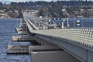
The Evergreen Point Floating Bridge, also known as the 520 Bridge and officially the Governor Albert D. Rosellini Bridge, carries Washington State Route 520 across Lake Washington from Seattle to its eastern suburbs. The 7,710-foot-long (2,350 m) floating span is the longest floating bridge in the world, as well as the world's widest measuring 116 feet (35 m) at its midpoint.

References

  1. 1 2 "National Register Information System". National Register of Historic Places . National Park Service. March 13, 2009.
  2. Josephson, Robert (September 12, 2007). "7 Engineering Wonders: Transportation/Infrastructure — Tunnels keep traffic flowing out of sight". Seattle Daily Journal of Commerce . HNTB. Retrieved May 7, 2016.
  3. Landmarks Alphabetical Listing for L Archived 2011-07-21 at the Wayback Machine , Individual Landmarks, Department of Neighborhoods, City of Seattle. Accessed December 28, 2007.
  4. 1 2 "Final List of Nationally and Exceptionally Significant Features of the Federal Interstate Highway System". US DOT . Retrieved May 29, 2018.
  5. "WSDOT historic bridges". Washington State Department of Transportation . Retrieved October 1, 2014.
  6. "Alaskan Way Viaduct and Seawall Replacement – Frequently Asked Questions [see 'What experience does WSDOT have with building tunnels?']". Washington State Department of Transportation. 2006. Archived from the original on September 29, 2006. Retrieved May 29, 2018.
  7. 1 2 3 4 Pryne, Eric (May 28, 1989). "The New Interstate 90 – The Thirty Years' War: Country's Most Costly Stretch of Road Is Story of Injunctions, Initiatives, Woes of High Finance and Much Mediation" . The Seattle Times . p. A1. Retrieved May 12, 2018 via NewsBank.
  8. 1 2 Gough, William (March 13, 1986). "The Light at the End of the I-90 Tunnel: Three Years Later, Excavation Is Done" . The Seattle Times . p. D1. Retrieved May 12, 2018 via NewsBank.
  9. 1 2 Gough, William (June 22, 1989). "That'll be one bridge – to go – The old I-90 closes tomorrow" . The Seattle Times . p. A1. Retrieved May 15, 2018 via NewsBank.
  10. "Eastbound I-90 lanes to close over weekend in shift to new bridge" . The Seattle Post-Intelligencer . June 23, 1989. p. B1. Retrieved May 15, 2018 via NewsBank.
  11. 1 2 3 4 5 6 Higgins, Mark (September 11, 1993). "I-90 sees the light at the 'in' of the tunnel" . The Seattle Post-Intelligencer . p. B1. Retrieved May 12, 2018 via NewsBank.
  12. 1 2 3 Clarke, Jonathan (August 1993). Historic American Engineering Record (HAER) No. WA-109: Mount Baker Ridge Tunnel (PDF) (Report). National Park Service . Retrieved May 12, 2018.
  13. Gough, William (October 3, 1985). "The New I-90: There's Light at the End of the Tunnel". The Seattle Times . p. D1.
  14. Robinson, Robert A. "Tunneling in Seattle – A History of Innovation" . Retrieved May 17, 2017.{{cite journal}}: Cite journal requires |journal= (help)