Evergreen Point Floating Bridge (1963) | |
---|---|
The bridge in 2009. Column-supported high-rises near the ends of the bridge are connected by a floating section. | |
Coordinates | 47°38′26″N122°15′36″W / 47.6405°N 122.26°W |
Carries | 4 lanes of ![]() |
Crosses | Lake Washington |
Locale | Seattle to Medina (Washington, U.S.) |
Official name | Governor Albert D. Rosellini Bridge |
Maintained by | Washington State Department of Transportation |
Characteristics | |
Design | Pontoon bridge with movable midsections |
Total length | 7,578 feet (2,310 m) |
History | |
Opened | August 28, 1963 |
Closed | April 22, 2016 |
Replaced by | Evergreen Point Floating Bridge replacement (2016) |
Location | |
![]() |
The Evergreen Point Floating Bridge, officially the Governor Albert D. Rosellini Bridge, and commonly called the SR 520 Bridge or 520 Bridge, was a floating bridge in the U.S. state of Washington that carried State Route 520 across Lake Washington, connecting Medina with the Montlake neighborhood of Seattle.
The bridge's total length was approximately 15,580 feet (4,750 m). [1] Its 7,578-foot (2,310 m) [2] floating section was the longest floating bridge in the world until April 11, 2016, when its replacement exceeded it by 130 feet (40 m).
The bridge was named for Evergreen Point, the westernmost of the three small Eastside peninsulas that SR 520 crosses. (The other two are Hunts Point and Yarrow Point.) In 1988, it was renamed for the state's 15th governor, Albert D. Rosellini, who had advocated its construction. [3]
Although there were plans to replace the bridge several years following its completion, [4] it was not until much later that investigations revealed the aging bridge to be in poor condition and unable to withstand the major hazards for which it was originally designed. [5] This finding may have accelerated plans to finally replace it. In response to these hazards and the need to expand the current infrastructure, construction on a replacement began in 2012; the new bridge opened in April 2016. The original bridge was closed to traffic on April 22, 2016, and was disassembled over the following months.
The bridge was opened for commuter traffic on August 28, 1963, after three years of construction. [6] It was built as a four-lane toll bridge to provide easy access from Seattle to Eastside communities such as Bellevue, Kirkland, and Redmond. The total cost of the bridge, in 1961 dollars, was $21 million (at least $127 million in 2011 dollars [7] ). [8] To make up for this cost, commuters paid a 35-cent toll in each direction until June 22, 1979. [9] The tollbooths were removed and the plaza space was converted into a flyer stop for Metro Transit buses.[ citation needed ]
The bridge affected many communities on the Eastside. Redmond's population saw a dramatic increase, jumping from less than 1,500 in 1960 to 11,000 in 1970. [10] It was the second floating bridge to cross Lake Washington; the first was the Lake Washington Floating Bridge, built in 1940 as part of U.S. Route 10, later part of Interstate 90, [6] which at its construction was the largest floating structure ever built.[ citation needed ]
On November 4, 1972, two people drowned after their boat drifted and collided with the bridge's windward side during a winter storm. The remaining four people on the boat were later rescued. [11] The incident prompted the Department of Highways to install 88 safety ladders along the bridge. [6] [12]
On August 28, 1988, the bridge was officially renamed for governor Albert D. Rosellini; the Washington State Transportation Commission approved of the renaming three days earlier ahead of the bridge's 25th anniversary celebration. [13] At the time, 109,000 vehicles used the bridge on an average day and 529 million vehicles were estimated to have crossed it since it opened. [14]
The bridge was built with a drawspan in the center that could open for boats too tall to go under the bridge. [15] The bridge opened by raising two 100-foot-long (30 m) steel grids about 7 feet (2.1 m) and moving an adjacent pontoon beneath them. [16]
In 1989, an electrical fault caused the drawspan to open during rush hour, causing one death and five injuries. [16] In 2000, a gravel barge struck the bridge. [17]
Just five years after the bridge opened, a study commissioned by the state legislature was completed to figure out how to provide for the great demand for cross-lake transportation. That study evaluated bridge and tunnel crossings north and south of the bridge. [18] Other plans considered in the late 1980s proposed the addition of rail transit or bus lanes to add capacity. [19] To prepare a case for the state legislature, the Trans-Lake Study was commissioned to study various alternatives. [20] The study brought together 47 representatives of public agencies, neighborhoods, businesses, and advocacy interests. [21]
In 1997, Myint Lwin, WSDOT's chief bridge engineer, said that even with repairs, the bridge could be expected to last only about twenty more years (until 2017). [22] The bridge needed to be closed to traffic in high winds, and even after a seismic retrofit in 1999, it was at risk of collapse during an earthquake. Due to the weight of various reinforcements over the years, the bridge deck ultimately sat about 1 foot (30 cm) lower over the water than it did originally.[ citation needed ]
Since the bridge was built in the early 1960s, prior to the implementation of modern earthquake standards, its hollow support structures would have likely failed during a major earthquake. Additionally, vibrations induced by storm surges and strong winds could have compromised the drawspan, anchor cables, and pontoons, subjecting them to structural failure. [23] Even for storms below the maximum threshold for failure to occur, Washington State Department of Transportation (WSDOT) still closed the floating bridge to traffic. The original bridge carried two lanes of traffic in each direction, but did not include emergency shoulders or pedestrian and bicycle crossings. This posed traffic problems since any obstruction caused by car breakdown, wreck or maintenance would result in traffic backups. [24]
In 2011, WSDOT broke ground on the replacement bridge. [25] On April 2, 2016, WSDOT held a grand opening ceremony, allowing the public to explore the top deck of the new bridge on the westbound side. [26] The replacement bridge opened to westbound traffic on April 11, 2016, and opened to eastbound traffic on April 25, 2016. [27] The old bridge was permanently closed at 23:00 PDT on April 22, 2016, with demolition completed by the end of 2016.[ citation needed ] The bridge was removed by spring 2017. [28]
The cost of all improvements to SR-520 between I-5 and I-405, including the new bridge, is forecast to be $4.65 billion. [29]
The first of 21 longitudinal pontoons were positioned on August 11, 2012. Each pontoon is 360 feet (110 m) long and 75 feet (23 m) wide. [30] The pontoons were constructed in Aberdeen by Kiewit Construction. Pontoon construction was plagued by errors and shoddy construction. Reports included workers installing incorrectly sized rebar, installing it in the wrong location, and even having it missing altogether. Workers also poured concrete in weather that was too wet or too cold. Several of the new pontoons have had problems with cracking, which has been blamed on Kiewit's poor work. An independent auditor stated that there had been a long-running pattern of poor-quality work and that WSDOT failed to force Kiewit to take corrective actions. An inspector for the construction called it a disaster waiting to happen, adding "I won't drive across that bridge when they have it built." [31]
By the end of February 2015, enough of the new bridge was in place to block tall ships that used to pass through a drawspan in the Rosellini Bridge. [32] In early July 2015, the westernmost floating pontoon was moved to make room for the installation of the west end of the bridge; on July 8, 2015, all longitudinal pontoons for the new bridge were in place. [33]
When the bridge opened in 1963, a 35 cent toll was collected to pay off a construction bond. The sole toll plaza was located at the east end of the bridge in Medina and had nine booths. [34] The state government offered discounts to commuters using a ticket book, as well as carpools of two or more people. [35] [36] The toll was retired on June 22, 1979, after the $35 million bond had been paid off 20 years ahead of schedule. [37] More than 213 million vehicles had used the toll bridge and generated $59.6 million in revenue. [38] One of the former tollbooths was reused for a drive-through espresso stand in Juanita. [39]
Tolls were reinstated on December 29, 2011, to fund the original bridge's replacement. Within the first year, traffic levels declined by 30 percent and tolls generated $50 million in gross revenue. [40] ESHB 2211, which authorized tolling on the SR 520 bridge beginning in 2010 to fund the new bridge, was signed into law in May 2009 by governor Christine Gregoire. [41] The State Transportation Commission has proposed a toll of US$3.59 each way during peak periods. The proposed rates during other hours were to range from $0 to $2.87. [42]
All tolling was done automatically with no tollbooths. Tolling for people without "Good to Go" passes is done by license plates. [29] Toll readers were located on gantries at the east highrise, [43] but additional gantries on the east mainland were added to facilitate tolling on the new bridge once opened.
Tim Eyman promoted Initiative 1125, which among other measures, would have banned the time-of-day tolling proposed for the bridge, required funding to be used on the road that collected the toll, and required tolls to be set by elected officials. [44] The initiative was defeated by Washington voters. [45]
Lake Washington is a large freshwater lake adjacent to the city of Seattle, Washington, United States. It is the largest lake in King County and the second largest natural lake in the state of Washington, after Lake Chelan. It borders the cities of Seattle on the west, Bellevue and Kirkland on the east, Renton on the south, and Kenmore on the north, and encloses Mercer Island. The lake is fed by the Sammamish River at its north end and the Cedar River at its south.
State Route 520 (SR 520) is a state highway and freeway in the Seattle metropolitan area, part of the U.S. state of Washington. It runs 13 miles (21 km) from Seattle in the west to Redmond in the east. The freeway connects Seattle to the Eastside region of King County via the Evergreen Point Floating Bridge on Lake Washington. SR 520 intersects several state highways, including Interstate 5 (I-5) in Seattle, I-405 in Bellevue, and SR 202 in Redmond.
The Lacey V. Murrow Memorial Bridge is a floating bridge in the Seattle metropolitan area of the U.S. state of Washington. It is one of the Interstate 90 floating bridges that carries the eastbound lanes of Interstate 90 across Lake Washington from Seattle to Mercer Island. Westbound traffic is carried by the adjacent Homer M. Hadley Memorial Bridge.
State Route 99 (SR 99), also known as the Pacific Highway, is a state highway in the Seattle metropolitan area, part of the U.S. state of Washington. It runs 49 miles (79 km) from Fife to Everett, passing through the cities of Federal Way, SeaTac, Seattle, Shoreline, and Lynnwood. The route primarily follows arterial streets, including Aurora Avenue, and has several freeway segments, including the tolled SR 99 Tunnel in Downtown Seattle. SR 99 was officially named the William P. Stewart Memorial Highway by the state legislature in 2016, after a campaign to replace an unofficial moniker honoring Confederate president Jefferson Davis.
State Route 513 (SR 513) is a 3.35-mile-long (5.39 km) state highway in the U.S. state of Washington, located entirely within the city of Seattle in King County. The highway travels north as Montlake Boulevard from an interchange with SR 520 and over the Montlake Bridge to the University of Washington campus in the University District. SR 513 continues past University Village before it turns northeast onto Sand Point Way and ends at the entrance to Magnuson Park in the Sand Point neighborhood.
State Route 104 (SR 104) is a 31.75-mile-long (51.10 km) state highway in the U.S. state of Washington, serving four counties: Jefferson on the Olympic Peninsula, Kitsap on the Kitsap Peninsula, and Snohomish and King in the Puget Sound region. It begins south of Discovery Bay at U.S. Route 101 (US 101) and crosses the Hood Canal Bridge over Hood Canal to the terminus of SR 3 near Port Gamble. SR 104 continues southeast onto the Edmonds–Kingston Ferry to cross the Puget Sound and intersects SR 99 and Interstate 5 (I-5) before ending at SR 522 in Lake Forest Park. SR 104 also has a short spur route that connects the highway to SR 99 at an at-grade signal on the Snohomish–King county line.
The Hood Canal Bridge is a floating bridge in the northwest United States, located in western Washington. It carries State Route 104 across Hood Canal in Puget Sound and connects the Olympic and Kitsap Peninsulas. At 7,869 feet in length, it is the longest floating bridge in the world located in a saltwater tidal basin, and the third longest floating bridge overall. It opened in 1961 and was the second concrete floating bridge constructed in Washington. Since that time, it has become a vital link for local residents, freight haulers, commuters, and recreational travelers. The convenience it provides has had a major impact on economic development, especially in eastern Jefferson County.
Washington Park is a public park in Seattle, Washington, United States, most of which is taken up by the Washington Park Arboretum, a joint project of the University of Washington, the Seattle Parks and Recreation, and the nonprofit Arboretum Foundation. Washington Park also includes a playfield and the Seattle Japanese Garden in its southwest corner. To the north is Union Bay; to the west are Montlake and Madison Valley; to the south is the Washington Park neighborhood; and to the east is the Broadmoor Golf Club.
The Third Lake Washington Bridge, officially the Homer M. Hadley Memorial Bridge, is a floating bridge in the Seattle metropolitan area of the U.S. state of Washington. It is one of the Interstate 90 floating bridges, carrying the westbound lanes of Interstate 90 across Lake Washington between Mercer Island and Seattle. The floating bridge is the fifth-longest of its kind in the world, at 5,811 feet.
State Route 526 (SR 526), also known as the Boeing Freeway, is a state highway in Snohomish County, Washington, United States. The east–west highway travels 4.52 miles (7.27 km) and connects SR 525 in Mukilteo to Interstate 5 (I-5) in southern Everett. The highway serves the Boeing Everett Factory and Paine Field; it also serves as a main route to the city of Mukilteo and the state-run ferry to Whidbey Island.
Transportation in Seattle is largely focused on the automobile like many other cities in western North America; however, the city is just old enough for its layout to reflect the age when railways and trolleys predominated. These older modes of transportation were made for a relatively well-defined downtown area and strong neighborhoods at the end of several former streetcar lines, now mostly bus lines.
Interstate 405 (I-405) is a north–south auxiliary Interstate Highway serving the Seattle region of Washington, United States. It bypasses Seattle east of Lake Washington, traveling through the Eastside area of King and Snohomish counties, providing an alternate route to I-5. The 30-mile (48 km) freeway serves the cities of Renton, Bellevue, Kirkland, and Bothell. I-405 terminates at I-5 in Tukwila and Lynnwood, and also intersects several major highways, including SR 167, I-90, SR 520, and SR 522.
The Washington State Department of Transportation is a governmental agency that constructs, maintains, and regulates the use of transportation infrastructure in the U.S. state of Washington. Established in 1905, it is led by a secretary and overseen by the governor. WSDOT is responsible for more than 20,000 lane-miles of roadway, nearly 3,000 vehicular bridges and 524 other structures. This infrastructure includes rail lines, state highways, state ferries and state airports.
Good to Go, stylized as GoodToGo!, is the electronic toll collection program managed by the Washington State Department of Transportation on all current toll and future projects in the U.S. state of Washington. Regular Good to Go customers may set up an account from which tolls are automically deducted. Vehicles that are not linked to an account are photographed and a toll bill is sent to the registered owner by U.S. mail.
Interstate 90 (I-90), designated as the American Veterans Memorial Highway, is a transcontinental Interstate Highway that runs from Seattle, Washington, to Boston, Massachusetts. It crosses Washington state from west to east, traveling 298 miles (480 km) from Seattle across the Cascade Mountains and into Eastern Washington, reaching the Idaho state line east of Spokane. I-90 intersects several of the state's other major highways, including I-5 in Seattle, I-82 and U.S. Route 97 (US 97) near Ellensburg, and US 395 and US 2 in Spokane.
Interstate 5 (I-5) is an Interstate Highway on the West Coast of the United States that serves as the region's primary north–south route. It spans 277 miles (446 km) across the state of Washington, from the Oregon state border at Vancouver, through the Puget Sound region, to the Canadian border at Blaine. Within the Seattle metropolitan area, the freeway connects the cities of Tacoma, Seattle, and Everett.
The State Route 99 tunnel, also known as the Alaskan Way Viaduct replacement tunnel, is a bored highway tunnel in the city of Seattle, Washington, United States. The 2-mile (3.2 km), double-decker tunnel carries a section of State Route 99 (SR 99) under Downtown Seattle from SoDo in the south to South Lake Union in the north.
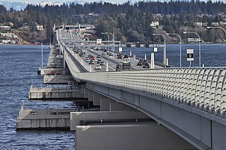
The Evergreen Point Floating Bridge, also known as the 520 Bridge and officially the Governor Albert D. Rosellini Bridge, is a floating bridge that carries Washington State Route 520 across Lake Washington from Seattle to its eastern suburbs. The 7,710-foot-long (2,350 m) floating span is the longest floating bridge in the world, as well as the world's widest measuring 116 feet (35 m) at its midpoint. It is a toll bridge and uses electronic collection.