Evergreen is an unincorporated town, a post office, and a census-designated place (CDP) located in and governed by Jefferson County, Colorado, U.S. The CDP is a part of the Denver–Aurora–Lakewood, CO Metropolitan Statistical Area. The Evergreen post office has the ZIP Codes 80439 and 80437. At the 2020 census, the population of the Evergreen CDP was 9,307. The Evergreen Metropolitan District provides services.

Hunts Point is a town in the Eastside, a region of King County, Washington, United States, and part of the Seattle metropolitan area. The town is on a small peninsula surrounded by Lake Washington, and is near the suburbs of Medina, Clyde Hill, Yarrow Point, and Kirkland, as well as the city of Bellevue. As of the 2020 census, the town had a total population of 457.

Kirkland is a city in King County, Washington, United States. A suburb east of Seattle, its population was 92,175 in the 2020 U.S. census which made it the sixth largest city in King County and the twelfth largest city in the state of Washington.

Shoreline is a city in King County, Washington, United States. It is located between the city limits of Seattle and the Snohomish County border, approximately 9 miles (14 km) north of Downtown Seattle. As of the 2020 census, the population of Shoreline was 58,608, making it the 22nd largest city in the state. Based on per capita income, one of the more reliable measures of affluence, Shoreline ranks 91st of 522 areas in the state of Washington to be ranked.

Lake Washington is a large freshwater lake adjacent to the city of Seattle, Washington, United States. It is the largest lake in King County and the second largest natural lake in the state of Washington, after Lake Chelan. It borders the cities of Seattle on the west, Bellevue and Kirkland on the east, Renton on the south, and Kenmore on the north, and encloses Mercer Island. The lake is fed by the Sammamish River at its north end and the Cedar River at its south.

TheEvergreen State College is a public liberal arts college in Olympia, Washington. Founded in 1967, it offers a non-traditional undergraduate curriculum in which students have the option to design their own study towards a degree or follow a pre-determined path of study. Full-time students can enroll in interdisciplinary academic programs, in addition to stand-alone classes. Programs typically offer students the opportunity to study several disciplines in a coordinated manner. Faculty write substantive narrative evaluations of students' work in place of issuing grades.
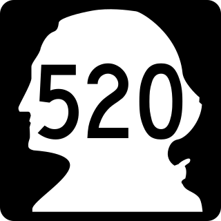
State Route 520 (SR 520) is a state highway and freeway in the Seattle metropolitan area, part of the U.S. state of Washington. It runs 13 miles (21 km) from Seattle in the west to Redmond in the east. The freeway connects Seattle to the Eastside region of King County via the Evergreen Point Floating Bridge on Lake Washington. SR 520 intersects several state highways, including Interstate 5 (I-5) in Seattle, I-405 in Bellevue, and SR 202 in Redmond.

The Lacey V. Murrow Memorial Bridge is a floating bridge in the Seattle metropolitan area of the U.S. state of Washington. It is one of the Interstate 90 floating bridges that carries the eastbound lanes of Interstate 90 across Lake Washington from Seattle to Mercer Island. Westbound traffic is carried by the adjacent Homer M. Hadley Memorial Bridge.

State Route 513 (SR 513) is a 3.35-mile-long (5.39 km) state highway in the U.S. state of Washington, located entirely within the city of Seattle in King County. The highway travels north as Montlake Boulevard from an interchange with SR 520 and over the Montlake Bridge to the University of Washington campus in the University District. SR 513 continues past University Village before it turns northeast onto Sand Point Way and ends at the entrance to Magnuson Park in the Sand Point neighborhood.
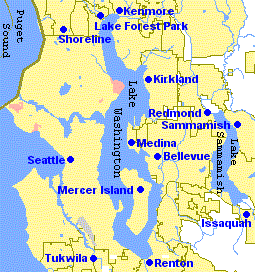
The Eastside of the King County, Washington area in the United States is a collective term for the suburbs of Seattle located on the east side of Lake Washington.

Washington Park is a public park in Seattle, Washington, United States, most of which is taken up by the Washington Park Arboretum, a joint project of the University of Washington, the Seattle Parks and Recreation, and the nonprofit Arboretum Foundation. Washington Park also includes a playfield and the Seattle Japanese Garden in its southwest corner. To the north is Union Bay; to the west are Montlake and Madison Valley; to the south is the Washington Park neighborhood; and to the east is the Broadmoor Golf Club.

Sun Lakes-Dry Falls State Park is a public recreation area located at the foot of Dry Falls, three miles (4.8 km) west of Coulee City in Grant County, Washington. The state park covers 3,774 acres (1,527 ha) along Route 17 at the head of the Lower Grand Coulee.

Battle Ground Lake State Park is a 280-acre (110 ha) public recreation area located three miles (4.8 km) northeast of the city of Battle Ground, Washington. The state park is covered by an evergreen forest that surrounds a crater lake of volcanic origin. The park is managed by the Washington State Parks and Recreation Commission.

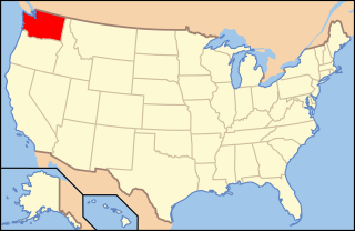
Washington, officially the State of Washington, is a state in the Pacific Northwest region of the United States. It is often referred to as Washington state or Washington State to distinguish it from the national capital, both named for George Washington. Washington borders the Pacific Ocean to the west, Oregon to the south, Idaho to the east, and the Canadian province of British Columbia to the north. The state was formed from the western part of the Washington Territory, which was ceded by the British Empire in the Oregon Treaty of 1846. It was admitted to the Union as the 42nd state in 1889. Olympia is the state capital, and the most populous city is Seattle.

Evergreen Washelli Memorial Park originated in 1885. It is located on both sides of Aurora Avenue in Seattle, Washington, and occupies roughly 144 acres. It is the largest cemetery in Seattle.
The Evergreen Premier League (EPLWA) is an amateur men's soccer league in the U.S. state of Washington affiliated with the United States Adult Soccer Association. The league was established in 2013 and is contested by ten teams— eight from Western Washington and two from Eastern Washington. The current champions are Bellingham United. The league is headquartered in Bellingham.
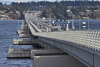
The Evergreen Point Floating Bridge, also known as the 520 Bridge and officially the Governor Albert D. Rosellini Bridge, carries Washington State Route 520 across Lake Washington from Seattle to its eastern suburbs. The 7,710-foot-long (2,350 m) floating span is the longest floating bridge in the world, as well as the world's widest measuring 116 feet (35 m) at its midpoint.
The following outline is provided as an overview of and topical guide to infrastructure of the U.S. state of Washington.