Eastside (King County, Washington)

Last updated

The Eastside is to the right (east) of Seattle. Seattle-lakewashington-lakesammamish.PNGRentonBellevueKenmoreLake Forest ParkKirklandMercer IslandShorelineWoodinvilleRedmondRedmondIssaquahSammamishMedinaTukwila
The Eastside is to the right (east) of Seattle.

The Eastside of the King County, Washington area in the United States is a collective term for the suburbs of Seattle located on the east side of Lake Washington.

Contents

The most common definitions of the Eastside include the cities of Bellevue, Kirkland, Redmond, Sammamish, Issaquah, Newcastle, and Mercer Island. [1] [2] [3]

The towns west of Bellevue, collectively known as the Gold Coast, are usually considered part of the Eastside. These include Beaux Arts Village, Clyde Hill, Hunts Point, Medina, and Yarrow Point.

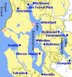
The Northshore cities of Kenmore, Bothell, and Woodinville may be considered part of the Eastside, as each city contains portions that are east of the lake and south of its northernmost tip. Similarly, on the southeast tip of Lake Washington, Renton may also be included.

The most expansive definitions of the Eastside can include cities in the Snoqualmie Valley, including Duvall, Carnation, Fall City, Snoqualmie, and North Bend.

In politics, the area is sometimes referred to as the "suburban crescent". [4]

History

Peter Kirk Building, built 1889-1890 as the Kirkland Investment Company Building. Now Kirkland Arts Center. Kirk Bldg 1889.JPG
Peter Kirk Building, built 1889–1890 as the Kirkland Investment Company Building. Now Kirkland Arts Center.

Several Indigenous peoples have lived on the Eastside for thousands of years prior to American colonization. The various subgroups of the Hachuamish, as well as the Sammamish, had many villages along the eastern coast of Lake Washington and the Sammamish River. [5] Although they were more contained to the southernmost reaches of the Eastside, the modern-day site of Renton was the center of Duwamish society. [6] Farther out in the Snoqualmie Valley, the Snoqualmie were historically one of the most populous tribes in the Puget Sound region. [7]

The cities on the Eastside mostly began as centers of logging or mining in the late 19th and early 20th centuries. Once logged, the land was eventually cleared (primarily by Japanese immigrant labor) to support farming. [8] In the years prior to World War II they became centers of dairy and berry farming.

During the post-war boom, they became bedroom communities for Seattle. This was made possible by the 1940 construction of the Lacey V. Murrow Memorial Bridge across Lake Washington, as well as the later construction of the Evergreen Point Floating Bridge in 1963; additional traffic later led to the construction of an additional bridge paralleling the Murrow bridge, Homer M. Hadley Memorial Bridge, as well as the replacement of the Evergreen Point Floating Bridge. Currently, the area is growing several edge cities.

Economy

Microsoft Building 17 Microsoft building 17 front door.jpg
Microsoft Building 17
View from Bellevue Downtown Park Bellevue Downtown Park, Washington - April 2012.JPG
View from Bellevue Downtown Park

Bellevue is the largest city on the Eastside and fifth largest in the state. A major technology center, the Eastside is home to many large high-tech companies, mainly in the software and wireless industries, including Microsoft, T-Mobile US, Nintendo of America, AT&T Mobility (formerly Cingular), the former Western Wireless (now part of Verizon Wireless), Vulcan Ventures, 180 Solutions and InfoSpace. Companies like Paccar, Puget Sound Energy, Symetra Insurance, Boeing, Verizon Wireless, Google, Amazon, Yahoo, Walt Disney, and Fox Sports also have national, major divisional or regional offices in the Eastside. The Eastside is also a hub for biotech and medical companies including Amgen, Icos, and Merck. Many local magnates, including Bill Gates, Steve Ballmer, John Stanton, and Craig McCaw, live in the Eastside's cities. The Eastside is also home to many video game and interactive media companies. These include Bungie, Valve, ArenaNet, Sucker Punch, Monolith Productions, Sony Online Entertainment, Warner Brothers Entertainment, Microsoft Game Studios, Epic Games, Unity Technologies and DigiPen Institute of Technology.

Kirkland hosts the annual Junior League Softball World Series. Kirkland Signature is also the own brand of Costco, which founded its first warehouse in Seattle (#1), and operates from its corporate headquarters in the Eastside city of Issaquah.


Demographics

For the purposes of population estimates, Eastside includes Bellevue, Kirkland, Redmond, Sammamish, Issaquah, Newcastle, Mercer Island, Woodinville, Kenmore, and Bothell.

City2020 [9] 2010 [9] 20001990198019701960
Bellevue 151,854122,363109,56986,87473,90361,19612,809
Kirkland 92,17548,78745,05440,05218,78514,9706,025
Redmond 73,25654,14445,25635,80023,31811,0201,426
Sammamish 67,45545,78034,104----
Bothell 48,16133,50530,15012,3457,9435,4202,237
Issaquah 40,05130,43411,2127,7865,5364,3131,870
Mercer Island 25,74822,69922,03620,81621,52219,047
Kenmore 23,91420,46018,6788,9177,281
Woodinville 13,06910,9389,194
Newcastle 13,01710,3807,73714,73612,245-
Eastside altogether548,700399,490332,990227,326170,533115,96624,367
King County 2,269,6751,931,2491,737,0341,507,3191,269,7491,156,633935,014
Eastside as percent of King county24.18%20.69%19.17%15.08%13.43%10.03%2.61%
Seattle 737,015608,660563,374516,259493,846530,831557,087
Seattle as percent of King county32.47%31.52%32.43%34.25%38.89%45.89%59.58%

Transportation

Air

There are public and private airfields on the Eastside. Major facilities include:

There is also a landing zone for paragliding at the base of Tiger Mountain at 47°30′01.6″N122°01′19.1″W / 47.500444°N 122.021972°W / 47.500444; -122.021972 . [10]

Rail

The Woodinville Subdivision is a rail line built in the late 19th century. In 2008, the Wilburton Tunnel was eliminated, severing the line. The right-of-way was purchased the same year by the Port of Seattle. [11] Eastside cities and King County purchased portions of the Port property for conversion to a rail trail called the Eastside Rail Corridor. [12]

Road

The Eastside is connected to Seattle by the Evergreen Point Floating Bridge from Medina (State Route 520) and the Lacey V. Murrow Memorial Bridge and Third Lake Washington Bridge from Bellevue via Mercer Island (Interstate 90). It is also served by Interstate 405, a loop route of Interstate 5 that runs to the east of Lake Washington from Tukwila to Lynnwood.

Related Research Articles

<span class="mw-page-title-main">King County, Washington</span> County in Washington, United States

King County is a county located in the U.S. state of Washington. The population was 2,269,675 in the 2020 census, making it the most populous county in Washington, and the 12th-most populous in the United States. The county seat is Seattle, also the state's most populous city.

<span class="mw-page-title-main">Bellevue, Washington</span> City in Washington, United States

Bellevue is a city in the Eastside region of King County, Washington, United States, located across Lake Washington from Seattle. It is the third-largest city in the Seattle metropolitan area, and the fifth-largest city in Washington. It has variously been characterized as a satellite city, a suburb, a boomburb, or an edge city. The population was 151,854 at the 2020 census. The city's name is derived from the French term belle vue.

<span class="mw-page-title-main">Woodinville, Washington</span> City in Washington, United States

Woodinville is a city in King County, Washington, United States. The population was 13,069 at the 2020 census. It is a part of the Seattle metro area. There is also a much larger population with Woodinville mailing addresses in adjacent unincorporated areas of King and Snohomish (Maltby) counties. Woodinville has waterfront parks on the Sammamish River, sweeping winery and brewery grounds, and densely wooded areas.

<span class="mw-page-title-main">Bothell, Washington</span> City in Washington, United States

Bothell is a city in King and Snohomish counties in the U.S. state of Washington. It is part of the Seattle metropolitan area, situated near the northeast end of Lake Washington in the Eastside region. It had a population of 48,161 residents as of the 2020 census.

<span class="mw-page-title-main">Lake Washington</span> Freshwater lake in the United States

Lake Washington is a large freshwater lake adjacent to the city of Seattle, Washington, United States. It is the largest lake in King County and the second largest natural lake in the state of Washington, after Lake Chelan. It borders the cities of Seattle on the west, Bellevue and Kirkland on the east, Renton on the south, and Kenmore on the north, and encloses Mercer Island. The lake is fed by the Sammamish River at its north end and the Cedar River at its south.

Chief Seattle Council is the local council governing the scouting activities of the Boy Scouts of America in a large part of the Puget Sound and Seattle area, including almost all of the Olympic Peninsula.

<span class="mw-page-title-main">Burke–Gilman Trail</span> Rail trail in Seattle, US

The Burke–Gilman Trail is a rail trail in King County, Washington. The 20-mile (32 km) multi-use recreational trail is part of the King County Regional Trail System and occupies an abandoned Seattle, Lake Shore and Eastern Railway (SLS&E) corridor.

<span class="mw-page-title-main">Factoria, Bellevue</span>

Factoria is a mixed-use suburban neighborhood in south Bellevue, Washington and is one of the city's significant commercial districts. Originally timberland from the 1890s to 1920s and later envisioned as an industrial center, Factoria has since the 1960s evolved into commercial and residential development. Factoria was annexed into Bellevue in 1993. The core neighborhood is bounded by Interstate 90 to the north, Interstate 405 to the west, Newport Way to the east, and Coal Creek Parkway to the south.

<span class="mw-page-title-main">Interstate 405 (Washington)</span> Interstate highway bypassing Seattle, Washington, U.S.

Interstate 405 (I-405) is a north–south auxiliary Interstate Highway serving the Seattle region of Washington, United States. It bypasses Seattle east of Lake Washington, traveling through the Eastside area of King and Snohomish counties, providing an alternate route to I-5. The 30-mile (48 km) freeway serves the cities of Renton, Bellevue, Kirkland, and Bothell. I-405 terminates at I-5 in Tukwila and Lynnwood, and also intersects several major highways, including SR 167, I-90, SR 520, and SR 522.

<span class="mw-page-title-main">King County Library System</span> Public library in Washington state, U.S.

The King County Library System (KCLS) is a library system serving most residents of King County, Washington, United States. Headquartered in Issaquah, Washington, KCLS was the busiest library system in the United States as of 2010, circulating 22.4 million items. It consists of 50 libraries, a Traveling Library Center, a mobile TechLab, and the ABC Express children’s library van. KCLS offers a collection of more than 4.1 million items, including books, periodicals, newspapers, audio and videotapes, films, CDs, DVDs and extensive online resources. All KCLS libraries offer free Wi-Fi connections. Patrons can check out 100 items at once and hold up to 50 items.

<span class="mw-page-title-main">Washington State Route 202</span> State highway in King County, Washington, US

State Route 202 (SR 202) is a state highway in the U.S. state of Washington, serving part of the Seattle metropolitan area. It runs southeasterly for 31 miles (50 km) in the Eastside region of King County, connecting Woodinville, Redmond, Fall City, and North Bend. The highway begins at SR 522 in Woodinville, intersects SR 520 in Redmond and SR 203 in Fall City, and terminates at Interstate 90 (I-90) in North Bend. The entire highway is designated as the Cascade Valleys Scenic Byway, a state scenic and recreational highway.

The Sammamish people are a Lushootseed-speaking Southern Coast Salish people. They are indigenous to the Sammamish River Valley in central King County, Washington. The Sammamish speak Lushootseed, a Coast Salish language which was historically spoken across most of Puget Sound, although its usage today is mostly reserved for cultural and ceremonial practices.

<span class="mw-page-title-main">Area code 425</span> Area code in Washington state, United States

Area code 425 is a telephone area code in the North American Numbering Plan (NANP) for the suburbs north and east of Seattle in the U.S. state of Washington. The numbering plan area includes the Eastside, extending east to North Bend, north to Everett, and south to Maple Valley. It also includes the cities of Bellevue and Redmond, both major employment centers. The area code was created in 1997 in a three-way split of area code 206.

<span class="mw-page-title-main">Lake Sammamish State Park</span> Park in Washington, US

Lake Sammamish State Park is a park at the south end of Lake Sammamish, in King County, Washington, United States. The park, which is administered by the Washington State Park System, covers an area of 512 acres (0.80 sq mi) and has 6,858 feet (2,090 m) of waterfront; Issaquah Creek meets with Lake Sammamish within the park. It is a popular location for boating and watersport activities, such as waterskiing.

The Woodinville Subdivision is a railroad line that was formerly owned by BNSF Railway. It takes its name from one of its original end points in Woodinville, Washington, United States. The line extends approximately 42 miles (68 km) in east King County and Snohomish County. The line's ownership has been transferred in a deal involving King County and the Port of Seattle. The section from Snohomish to Woodinville was operated, on contract, by a company called Eastside Rail Freight, which is associated with the Ballard Terminal Railroad and Meeker Southern. However, train traffic on the subdivision is exceedingly rare, with the Seattle region's rail operations now conducted on other higher capacity routes.

<span class="mw-page-title-main">Lake Washington steamboats and ferries</span> Defunct ferry system in Washington state

Lake Washington steamboats and ferries operated from about 1875 to 1951, transporting passengers, vehicles and freight across Lake Washington, a large lake to the east of Seattle, Washington. Before modern highways and bridges were built, the only means of crossing the lake, other than the traditional canoe or rowboat, was by steamboat, and, later, by ferry. While there was no easily navigable connection to Puget Sound, the Lake Washington Ship Canal now connects Lake Washington to Lake Union, and from there Puget Sound is reached by way of the Hiram M. Chittenden Locks.

<span class="mw-page-title-main">Eastside Rail Corridor</span> Rail trail in Washington state

The Eastside Rail Corridor, officially Eastrail, is a rail right of way where a rail trail has been under development in the Eastside suburbs of Seattle, Washington. The corridor follows the path of the former Woodinville Subdivision from Renton to the City of Snohomish at Snohomish Junction. As of 2017, the northern portion was still in operation by Eastside Freight Railroad.

References

  1. "Eastside Business Journal (Masthead)". Eastside Business Journal. December 2007. Archived from the original on January 6, 2008. Retrieved January 11, 2008.
  2. "Eastside Transportation Partnership Subareas (Map)" (PDF). Metro King County. April 2006. Archived from the original (PDF) on October 19, 2008. Retrieved January 11, 2008.
  3. "Subarea equity". Sound Transit. December 2007. Archived from the original on December 21, 2007. Retrieved January 11, 2008.
  4. KOMO Staff; News Services (September 17, 2002). "Primary Election Results". KOMO News. Archived from the original on April 2, 2012. Retrieved December 22, 2010.
  5. Buerge, David (August 1, 1984). "Indian Lake Washington" (PDF). Seattle Weekly . pp. 29–33. Retrieved January 10, 2024.
  6. Tollefson, Kenneth D. (1989). "Political Organization of the Duwamish". Ethnology. 28 (2): 135–149. doi:10.2307/3773671. ISSN   0014-1828. JSTOR   3773671 . Retrieved January 10, 2024.
  7. Krishnan, Sonia (January 4, 2005). "Snoqualmie Tribe on road to self-sufficiency". National Association of Tribal Historic Preservation Officers . Retrieved January 10, 2024.
  8. Neiwert, David (2005). Strawberry Days . Palgrave Macmillan. pp.  11, 31. ISBN   978-1403967923.
  9. 1 2 "Census". September 3, 2024.
  10. "Site guide: Tiger Mountain". Northwest Paragliding Club. Archived from the original on August 2, 2013. Retrieved December 14, 2012.
  11. Eastside Rail Corridor, Port of Seattle
  12. Cross Kirkland Corridor, City of Kirkland, 2012

47°36′N122°10′W / 47.600°N 122.167°W / 47.600; -122.167