Montlake, Seattle

Last updated
Montlake, Seattle
Seattle Yacht Club 06.jpg
The Seattle Yacht Club in the Montlake neighborhood is on the National Register of Historic Places.
Seattle Map - Montlake.png
Montlake Highlighted in Pink
Coordinates: 47°38′33″N122°18′19″W / 47.64250°N 122.30528°W / 47.64250; -122.30528
CountryUnited States
State Washington
County King
City Seattle
Time zone UTC−8 (PST)
  Summer (DST) UTC−7 (PDT)
ZIP Code
98112
Area Code 206
St. Demetrios Greek Orthodox Church Seattle - St. D's from north.jpg
St. Demetrios Greek Orthodox Church
Home on Boyer Avenue Seattle - Boyer-Lambert House 04.jpg
Home on Boyer Avenue

Montlake is a wealthy residential neighborhood in central Seattle, Washington. It is located along the Montlake Cut of the Lake Washington Ship Canal, bounded to the north by Portage Bay, to the east by the Washington Park Arboretum, [1] and to the south and west by Interlaken Park.[ citation needed ] Capitol Hill is on its south and west sides, and the University of Washington campus lies across the Montlake Cut to the north. State Route 520 runs through the northern tip of Montlake, isolating four blocks from the rest of the neighborhood. The (unofficial) City Clerk's map of Montlake considers it to extend further west, past Interlaken Park, extending to Broadway Avenue E. and, between Lynn Street and State Route 520, all the way to Interstate 5. [1]

Contents

Though sports at the University of Washington are referred to metonymically as "Montlake," [2] [3] [4] UW sports facilities are not located within the traditional bounds of the neighborhood; [1] instead, they are located on Montlake Boulevard, across the Montlake Cut from the neighborhood.

History

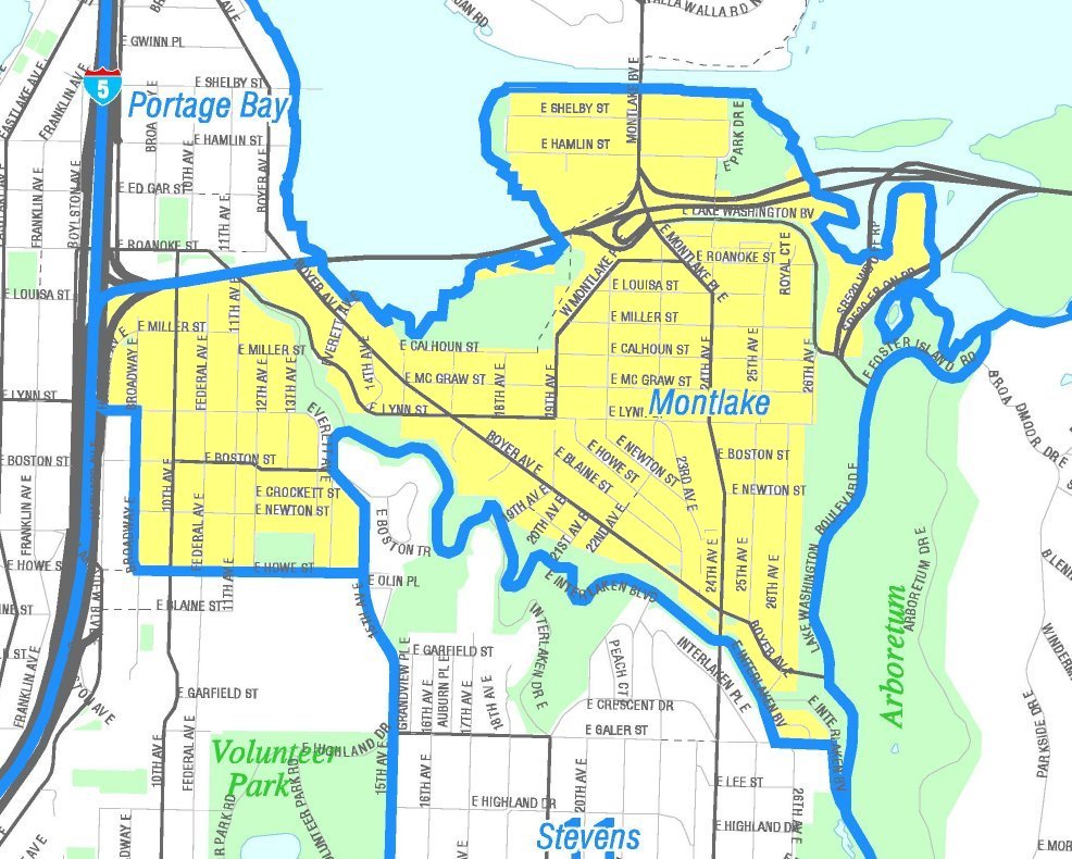
Montlake was primarily developed by John E. Boyer and Herbert Turner (also known as H.S. Turner) from 1903 through the early 1930s. In 1916, the northern boundary of Montlake was fixed by the opening of the New Portage Canal, later known as the Montlake Cut, between Lake Washington and Lake Union. The Montlake Bridge, a distinctive bascule bridge crossing the Montlake Cut, opened in 1925. [5]

In 1925, a Montlake neighbor made a low offer for a tiny slice of adjoining land. Out of spite for the low offer, the builder built an 860-square-foot (80 m2) house at 2022 24th Avenue E. that blocked the neighbors' open space. The house is 55 inches (1.4 m) wide at the south end and 15 feet (4.6 m) wide at the north end. The Montlake Spite House still is standing and occupied. [6]

The Montlake Community Club, an organization of neighborhood residents, has a distinguished history of grassroots activism. (Critics have called it NIMBY-ism.[ citation needed ]) Montlake first became politically active in a failed battle to move or avoid building State Route 520 through the northern section of the neighborhood and the arboretum. The neighborhood's efforts were unsuccessful and SR 520 was opened in 1963.[ citation needed ]

The Montlake Community Club lobbied to halt planning of the R.H. Thomson Expressway project of the 1960s. The expressway was to be a second north–south freeway through the city, parallel to Interstate 5 but cutting through Ravenna, Montlake, Madison Valley, and the Central District, taking out the western section of the Arboretum in the process. It was designed as a bypass around Downtown for through traffic. Interchanges with State Route 520 and I-90 were planned, the former being partially built, but the project was halted before construction went further. Never-used on- and off-ramps stood at the north end of the Arboretum until the SR 520 bridge expansion of the 2010s. [7]

Members of the Montlake community continue to negotiate with state and local officials over planned improvements to SR 520 and other local roads. Recently,[ when? ] a neighborhood group called Better Bridge endorsed a proposal to expand SR 520 to six lanes, move it north, and build a lid over the existing 520 freeway to reconnect the Shelby and Hamlin blocks to the rest of the neighborhood. The proposal has been endorsed by some members of Seattle City Council but has not yet been formally approved.[ when? ][ citation needed ]

Montlake saw a spike in housing prices and the demolition or renovation of several smaller homes starting in the late 1980s, as new residents bought up properties in the neighborhood because of its charm, good schools, and central location.[ citation needed ]

Characteristics

The neighborhood's main thoroughfares are Boyer Avenue E. (northwest- and southeast-bound), 24th Avenue E. and Lake Washington and Montlake Boulevards E. (north- and southbound), and E. Lake Washington Boulevard (east- and westbound).[ citation needed ]

Montlake has a very small commercial corridor along 24th Avenue East. It includes the Italian restaurant Cafe Lago, neighborhood pub Montlake Alehouse, Mr. Johnson's Antiques, a Seattle Public Library branch, and formerly a small market and dry cleaner.[ citation needed ]

The houses in Montlake are primarily single-family homes, mainly early 20th century American Craftsman bungalow and Tudor style. Also distinctive are the Old Seattle-style brick and wood frame homes of the early 20th century, particularly those bordering the Montlake Community Center.[ citation needed ]

Montlake has one church, the Greek Orthodox St. Demetrios, built in 1963 on the grounds of a former garden business called Dahlialand. [8]

Montlake was the home of the Museum of History & Industry from 1952 to 2012 [9] and is currently the home of the Seattle Yacht Club (1920) and the Northwest Fisheries Science Center (1931), part of the National Marine Fisheries Service.[ citation needed ]

Montlake's median household income is $208,636 according to the 2019 U.S. Census 5-Year estimate, compared to $92,263 citywide. [10] [11]

Related Research Articles

<span class="mw-page-title-main">Lake Union</span> Lake in Seattle, Washington, U.S.

Lake Union is a freshwater lake located entirely within the city limits of Seattle, Washington, United States. It is a major part of the Lake Washington Ship Canal, which carries fresh water from the much larger Lake Washington on the east to Puget Sound on the west. The easternmost point of the lake is the Ship Canal Bridge, which carries Interstate 5 over the eastern arm of the lake and separates Lake Union from Portage Bay. Lake Union is the namesake of the neighborhoods located on three of its shores: Eastlake, Westlake and South Lake Union. Notable destinations on the lake include Lake Union Park, the Museum of History & Industry (MOHAI), and the Center for Wooden Boats on the southern shore and Gas Works Park on the northern shore.

<span class="mw-page-title-main">Montlake Cut</span>

The Montlake Cut is the easternmost section of the Lake Washington Ship Canal, which passes through the city of Seattle, linking Lake Washington to Puget Sound. It opened in 1916 after 56 years of conversation and construction to create the manmade canal.

<span class="mw-page-title-main">Union Bay Natural Area</span> Restored remainder of the former Union Bay and Union Bay Marsh

The Union Bay Natural Area (UBNA) in Seattle, Washington, also known as Union Bay Marsh, is the restored remainder of the filled former Union Bay and Union Bay Marsh. It is located at the east end of the main University of Washington campus, south of NE 45th Street and west of Laurelhurst. Ravenna Creek is connected to University Slough, thence to Union Bay, and Lake Washington. Drainage Canal is one of three or four areas of open water connected with Lake Washington around Union Bay Marsh. The canal extends from NE 45th Street, between the driving range and IMA Sports Field 1, south to the bay, ending southeast of the Husky Ballpark baseball grandstand. The Drainage Canal that carries Ravenna Creek past UBNA to Union Bay is locally sometimes called University Slough.

<span class="mw-page-title-main">Union Bay (Seattle)</span> Bay of Lake Washington in Seattle

Union Bay is a body of water located in Seattle, Washington. Part of Lake Washington, it is bounded by the Laurelhurst neighborhood to the north and the Montlake and Madison Park neighborhoods to the south. The Evergreen Point Floating Bridge, which carries State Route 520, crosses over a portion of the bay.

<span class="mw-page-title-main">Portage Bay</span>

Portage Bay is a body of water, often thought of as the eastern arm of Lake Union, that forms a part of the Lake Washington Ship Canal in Seattle, Washington.

<span class="mw-page-title-main">Roosevelt, Seattle</span> Neighborhood in King, Washington, United States

Roosevelt is a neighborhood in north Seattle, Washington. Its main thoroughfare, originally 10th Avenue, was renamed Roosevelt Way upon Theodore Roosevelt's death in 1919. The neighborhood received the name as the result of a Community Club contest held eight years later, in 1927.

<span class="mw-page-title-main">Washington State Route 520</span> Freeway in Washington state

State Route 520 (SR 520) is a state highway and freeway in the Seattle metropolitan area, part of the U.S. state of Washington. It runs 13 miles (21 km) from Seattle in the west to Redmond in the east. The freeway connects Seattle to the Eastside region of King County via the Evergreen Point Floating Bridge on Lake Washington. SR 520 intersects several state highways, including Interstate 5 (I-5) in Seattle, I-405 in Bellevue, and SR 202 in Redmond.

<span class="mw-page-title-main">Museum of History & Industry</span> Museum in Seattle, Washington

The Museum of History & Industry (MOHAI) is a history museum in the South Lake Union neighborhood of Seattle, Washington, United States. It is the largest private heritage organization in Washington state, maintaining a collection of nearly four million artifacts, photographs, and archival materials primarily focusing on Seattle and the greater Puget Sound region. A portion of this collection is on display in the museum's galleries at the historic Naval Reserve Armory in Lake Union Park.

<span class="mw-page-title-main">Montlake Bridge</span> Drawbridge in Seattle, Washington, United States

The Montlake Bridge is a double-leaf bascule bridge that carries State Route 513 over Seattle's Montlake Cut—part of the Lake Washington Ship Canal—connecting Montlake and the University District.

<span class="mw-page-title-main">Washington State Route 513</span> Highway in Washington

State Route 513 (SR 513) is a 3.35-mile-long (5.39 km) state highway in the U.S. state of Washington, located entirely within the city of Seattle in King County. The highway travels north as Montlake Boulevard from an interchange with SR 520 and over the Montlake Bridge to the University of Washington campus in the University District. SR 513 continues past University Village before it turns northeast onto Sand Point Way and ends at the entrance to Magnuson Park in the Sand Point neighborhood.

<span class="mw-page-title-main">Washington Park Arboretum</span> Arboretum at the University of Washington

Washington Park is a public park in Seattle, Washington, United States, most of which is taken up by the Washington Park Arboretum, a joint project of the University of Washington, the Seattle Parks and Recreation, and the nonprofit Arboretum Foundation. Washington Park also includes a playfield and the Seattle Japanese Garden in its southwest corner. To the north is Union Bay; to the west are Montlake and Madison Valley; to the south is the Washington Park neighborhood; and to the east is the Broadmoor Golf Club.

<span class="mw-page-title-main">Ravenna, Seattle</span> Seattle neighborhood

Ravenna is a neighborhood in northeastern Seattle, Washington named after Ravenna, Italy. Though Ravenna is considered a residential neighborhood, it also is home to several businesses, many of which are located in the University Village, a shopping mall.

<span class="mw-page-title-main">South Lake Union, Seattle</span> Neighborhood of Seattle

South Lake Union is a neighborhood in Seattle, Washington, so named because it is at the southern tip of Lake Union.

<span class="mw-page-title-main">Licton Springs, Seattle</span> Seattle Neighborhood in King, Washington, United States

Licton Springs or North College Park is a neighborhood in the informal Northgate district of North Seattle. It is bounded by Interstate 5 to the east, beyond which is Maple Leaf neighborhood and the Northgate Mall; Aurora Avenue N to the west, beyond which is Greenwood; N 85th Street to the south, beyond which is Green Lake, and N Northgate Way to the north, beyond which is Haller Lake.

<span class="mw-page-title-main">Matthews Beach, Seattle</span> Seattle Neighborhood in King, Washington, United States

Matthews Beach is a neighborhood in Seattle, Washington; it and Meadowbrook are the southern neighborhoods of the annexed township of Lake City (1954). Matthews Beach lies about 2 miles (3.2 km) northeast of the University of Washington, about 8 miles (13 km) northeast of Downtown.

<span class="mw-page-title-main">McCurdy Park</span> Park in Seattle, Washington, U.S.

McCurdy Park was a 1.5-acre (6,100 m2) park in the Montlake neighborhood of the U.S. city of Seattle, Washington. Formerly home to the Museum of History and Industry, it was effectively bounded on the west by the museum and East Montlake Park, on the south by State Route 520, on the east by the Washington Park Arboretum, and on the north by Union Bay marshland. However, there was no obvious demarcation between McCurdy Park, East Montlake Park, and the Arboretum.

<span class="mw-page-title-main">Lake Washington Boulevard</span> Route through Seattle, Washington

Lake Washington Boulevard is a scenic, approximately 8-mile (13 km), road through Seattle, Washington, that hugs Lake Washington for much of the route. There are views of the lake, small sections of rainforest, meadows, and views of the Cascade mountains. At its northern end, Lake Washington Boulevard originates as East Lake Washington Boulevard at Montlake Boulevard East, soon becomes Lake Washington Boulevard East, and runs through the length of the Washington Park Arboretum. The road begins at S. Juneau Street in Seward Park, running thence along the lake to Colman Park, just south of Interstate 90. From here north to E. Alder Street in Leschi, the lakeside road is named Lakeside Avenue, and Lake Washington Boulevard diverts to a winding route through Colman, Frink, and Leschi Parks. At E. Alder, the boulevard once again runs along the lake through Madrona Park to just north of Madrona Drive, where private residences occupy the shore. At E. Denny-Blaine Place, the road heads northwest, through Lakeview Park and the grounds of The Bush School, to the south entrance of the Arboretum at E. Madison Street. It continues through the Arboretum. Just north of E. Roanoke Street, the boulevard turns due west and changes from Lake Washington Boulevard E. to E. Lake Washington Boulevard, following the city's street name designation system. The boulevard ends at the Montlake overpass of 520, where E. Montlake Place E. becomes Montlake Boulevard E.

<span class="mw-page-title-main">University of Washington station</span> Light rail station in Seattle, Washington

University of Washington station is a light rail station on the University of Washington campus in Seattle, Washington, United States. The station is served by the 1 Line of Sound Transit's Link light rail system, which connects Northgate, Downtown Seattle, and Seattle–Tacoma International Airport. University of Washington station is at the intersection of Montlake Boulevard Northeast and Northeast Pacific Street, adjacent to Husky Stadium and the University of Washington Medical Center.

<span class="mw-page-title-main">Campus of the University of Washington</span>

The Campus of the University of Washington is located in the University District of Seattle. Campus buildings are categorized by the major street or vicinity on which they are located on campus. In 2011, Slate magazine and Travel+Leisure described the Seattle campus as one of the most beautiful university campuses in the United States.

References

  1. 1 2 3 "Montlake" (JPEG). Seattle City Clerk's Geographic Indexing Atlas. Seattle City Clerk. Retrieved 2023-02-10.
  2. Thiel, Art; Columnist, P.-I. (2007-01-22). "Mora's move generates intrigue". seattlepi.com. Retrieved 2019-12-02.
  3. "Petersen To Step Down, Lake Named New Huskies' Head Coach". Washington Huskies. Retrieved 2019-12-02. I will forever be grateful, honored and humbled to have had the opportunity to coach our fine young men on Montlake for these past six seasons.
  4. Allen, Percy (2019-02-19). "The Huskies have returned to prominence in the Pac-12, and so has the roar on Montlake". The Seattle Times. Retrieved 2019-12-02.
  5. Ketcherside, Rob (2023-02-10). "New Seattle history, mostly Montlake crossings in a simple timeline". ba-kground. Seattle. Retrieved 2023-02-10.
  6. Kossen, Bill (October 29, 2000). "Homing in on the city of the $15,000 sofa". The Seattle Times. p. 4. Retrieved August 1, 2020.
  7. Lindblom, Mike (2013-01-24). "520 'ramps to nowhere' to come down". The Seattle Times. Retrieved 2021-12-01. ...the state announced Thursday it will tear down the so-called "ramps to nowhere," between 2014 and 2016, as part of the $4.1 billion Highway 520 bridge replacement.
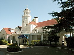
  8. Dorothea Mootafes, Theodora Dracopoulos Argue, Paul Plumis, Perry Scarlatos, Peggy Falangus Tramountanas, eds., A History of Saint Demetrios Greek Orthodox Church and Her People, Saint Demetrios Greek Orthodox Church, 2007 (1996). p. 119-120.
  9. "MOHAI grand opening set for Dec. 29 at South Lake Union site". The Seattle Times. 2012-12-07. Retrieved 2021-12-02. Established by a nonprofit historic association, MOHAI has existed since 1952, tracking and portraying the region's history with displays, programs and artifacts.
  10. "Neighborhood Snapshots: Montlake" (PDF). Seattle Department of Neighborhoods. May 2018. Retrieved August 1, 2020.
  11. "Census profile: Census Tract 62, King, WA". Census Reporter. Retrieved 2021-06-01.

Further reading