Columbia City, Seattle

Last updated
Columbia City
Seattle Map - Columbia City.png
Map of Columbia City's location in Seattle
Country United States
State Washington
City Seattle
City Council District 2
Neighborhood CouncilSoutheast District
Police District South Precinct, R3
Established [1] Incorporated in 1893 and Annexed to Seattle in 1907
Founded byJ. K. Edmiston
Named for Christopher Columbus
Population
[2]
  Total13,031
ZIP code
98118
Rainier Arts Center seen from Columbia Park. The center is a former Christian Science church, built 1921. Rainier Valley Cultural Center.jpg
Rainier Arts Center seen from Columbia Park. The center is a former Christian Science church, built 1921.
Butcher shop, Columbia City, 2007 Seattle - Columbia City - Bob's Quality Meats 02.jpg
Butcher shop, Columbia City, 2007

Columbia City is a neighborhood in southeastern Seattle, Washington, within the city's Rainier Valley district. It has a landmark-protected historic business district and is one of the few Seattle neighborhoods with a long history of ethnic and income diversity. [3]

Contents

The neighborhood's main thoroughfares running north–south are Rainier Avenue S. and Martin Luther King Jr. Way S. The principal east–west thoroughfares are S. Alaska Street, S Orcas Street, and S. Genesee Street. Mass transit includes Sound Transit's Central Link light rail service from the Columbia City station (approx. 15 minutes to downtown Seattle and 20 minutes to SeaTac airport).

History

Founding and early years

The area was once dense conifer forest, primarily inhabited by Coast Salish peoples, until the arrival of the Rainier Valley Electric Railway from Downtown Seattle in 1891. Owners of the electric railway bought forty acres, built a lumber mill, cleared the area for settlement, and promoted their town development under the name "Columbia" – named after Christopher Columbus. Three streets in the neighborhood have names of other famous explorers (a Columbia Street already existed Downtown): Ferdinand Street after Magellan, Hudson Street after Henry Hudson, and Americus Street after Amerigo Vespucci. [4] Lots in 1891 were sold under a canvas tent with the slogan "Columbia, Watch It Grow!" attached to the railway cars. [4]

Columbia incorporated as "Columbia City" in January 1893. Annexation to the City of Seattle came May 3, 1907 [5] following a petition by citizens to the City Council to hold a special election on the matter. [6] Although opposition to annexation had initially been strong due to citizens' desire for local control, the March 5 vote was overwhelming: 109-3 in favor of annexation to Seattle. [5]

In 1905, the newly renamed Seattle Renton & Southern Railway extended south to Renton. In 1912 the streetcar line went bankrupt and was reorganized as the Seattle & Rainier Valley Railway. Its last run was just after midnight on January 1, 1937. [4] Meanwhile, Columbia City's ambitions to become a seaport were thwarted with the completion of the Lake Washington Ship Canal in 1917, which lowered Lake Washington by nine feet and caused Wetmore Slough to dry up. The former slough was used as a dump from 1941 to 1963, and is now Genesee Park. [4]

A major early employer was the Hitt Fireworks Company (1905–1960s) located at what is now Hitt's Hill Park. It employed 200 workers in the 1930s and was credited for firework displays at several world's fairs and Fourth of July celebrations. During World War II it produced smoke screens and parachute flares. The Hitt Fireworks Company also provided pyrotechnic effects for some major release films including Gone with the Wind . [7]

1960s–present

As African Americans moved to Seattle to be part of the wartime industrial boom, many settled in the area, and in the 1960s the area began to suffer the effects of redlining and racism. By the 1970s, the neighborhood had fallen victim to poverty, housing stock had deteriorated, and many storefronts along Rainier Avenue S. were vacant.

The Columbia City business district was added to the National Register of Historic Places in 1980 as the Columbia City Historic District, extending north to S. Alaska Street, south to the intersection of 39th Ave S and Rainier Ave S, east to 39th Ave S., and west to the alley east of 35th Ave S. [8] [9]

Beginning in the late 1980s, Columbia City saw a large influx of minority professionals, artists, gay and lesbian couples and "urban pioneers" seeking classic housing stock at low prices. By the late 1990s, Columbia City was already referred to as one of Seattle's most creative neighborhoods. In the last decade,[ as of? ] it has seen some of the sharpest rises in property values in the entire Seattle metropolitan area. The result has been widespread gentrification, including the restoration of many of the older homes and, in the last several years, the building of numerous condos and the planned construction of several hundred more. [10] As of 2008, Columbia City is one of Seattle's most diverse neighborhoods in terms of income and ethnicity, encompassing everything from public housing to multimillion-dollar view homes.

Neighborhood character

Rainier Avenue in Columbia City Rainier Avenue; Columbia City, Seattle.JPG
Rainier Avenue in Columbia City

Today, the thriving pedestrian business district along Rainier Avenue S. is home to six bars, a grocery store, a number of restaurants, bakeries, coffee shops, assorted retail, an art gallery, fitness facilities, a fraternal clubhouse, a movie theater, and multiple live music venues.

Housing stock include craftsman bungalows, a mix of market-rate and low-income apartment buildings, and townhome developments. Community estimates have put the number of new homes in the planning pipeline as numbering at least 1,500. [11] Many of these developments are in formerly vacant lots.

Train service at the neighborhood's Link Light Rail station began in July 2009, connecting the neighborhood to both SeaTac airport and Downtown Seattle. Rainier Vista, once a post-war suburban public housing project, has been redeveloped into a mixed-use, mixed income community built around the light rail station, and includes more than 900 new homes (some subsidized, some rental, some owner-occupied).[ citation needed ]

Community organizations

Bike Works is a community charity that lets kids earn bikes by learning to repair them. The Boys and Girls Club has opened a new regional facility in the neighborhood. The neighborhood's large Genesee Park and Playfield is also the site of the Rainier Valley Community Center. The Rainier Arts Center and Southside Commons on either sides of Columbia Park are spaces for arts and cultural events. The Rainier Valley Historical Society documents and interprets the history of the larger district. The SouthEast Economic Development organization operates a number of affordable housing units and supports economic development and the arts, including Columbia City Gallery and the Rainier Arts Center, in the district.

Festivals and events

The Rainier Valley Heritage Parade and Summer Streets Party happens in August. Beatwalk is a live music series on the streets and in business within the Historic District, happening on second Sundays of June through September. A farmer's market operates May to mid-October along S Edmunds St with many in the neighborhood gathering for a dinner picnic in adjacent Columbia Park. HONK! Fest West happens the first weekend of June each year. HONK! Fest West is an accessible community music festival driven by the energetic performances of street bands in public spaces.


Registered historic places

The following structures in Columbia City are listed on the National Register of Historic Places:

Rainier Avenue; Columbia City, Seattle.JPG Columbia City Historic District (Seattle, Washington) Extends north to S. Alaska Street, south to the intersection of 39th Ave S and Rainier Ave S, east to 39th Ave S., and west to the alley east of 35th Ave S (Added in 1980, ID #80004000)
Columbia City Library.jpg Seattle Public Library - Columbia City Branch Carnegie-funded library built in 1915. Situated in Columbia Park at 4721 Rainier Avenue S (Added in 1982, ID #82004909)

Related Research Articles

<span class="mw-page-title-main">Chinatown–International District, Seattle</span> Historic district in Washington, United States

The Chinatown–International District is a neighborhood of Seattle, Washington. It is the center of the city's Asian American community. Within the district are the three neighborhoods known as Chinatown, Japantown and Little Saigon, named for the concentration of businesses owned by people of Chinese, Japanese and Vietnamese descent, respectively. The geographic area also once included Manilatown.

<span class="mw-page-title-main">Capitol Hill, Seattle</span> Neighborhood in Seattle, Washington, United States

Capitol Hill is a densely populated residential district and a neighborhood in Seattle, Washington, United States. It is immediately east of Downtown Seattle and north of First Hill. The neighborhood is one of the city's most popular nightlife and entertainment districts and is home to a historic gay village and vibrant counterculture community.

<span class="mw-page-title-main">Downtown Seattle</span> Central business district of Seattle, Washington, U.S.

Downtown is the central business district of Seattle, Washington. It is fairly compact compared with other city centers on the U.S. West Coast due to its geographical situation, being hemmed in on the north and east by hills, on the west by Elliott Bay, and on the south by reclaimed land that was once tidal flats. It is bounded on the north by Denny Way, beyond which are Lower Queen Anne, Seattle Center, and South Lake Union; on the east by Interstate 5, beyond which is Capitol Hill to the northeast and Central District to the east; on the south by S Dearborn Street, beyond which is Sodo; and on the west by Elliott Bay, a part of Puget Sound.

<span class="mw-page-title-main">West Seattle</span> Neighborhood between the Duwamish River and Puget Sound

West Seattle is a conglomeration of neighborhoods in Seattle, Washington, United States. It comprises two of the thirteen districts, Delridge and Southwest, and encompasses all of Seattle west of the Duwamish River. It was incorporated as an independent town in 1902 before being annexed by Seattle five years later. Among the area's attractions are its saltwater beach parks along Elliott Bay and Puget Sound, including Alki Beach Park and Lincoln Park. The area is also known for its views of the Olympic Mountains to the west and the Cascade Range to the east. One-third of Seattle's green space and urban forest is located in West Seattle, much of it in the West Duwamish Greenbelt.

<span class="mw-page-title-main">Beacon Hill, Seattle</span> Seattle neighborhood in King, Washington, United States

Beacon Hill is a hill and neighborhood in southeastern Seattle, Washington. It is roughly bounded on the west by Interstate 5, on the north by Interstate 90, on the east by Rainier Avenue South, Cheasty Boulevard South, and Martin Luther King Junior Way South, and on the south by the Seattle city boundary. It is part of Seattle's South End.

<span class="mw-page-title-main">Central District, Seattle</span> Seattle Neighborhood in King, Washington, United States

The Central Area is a mostly residential neighborhood in Seattle located east of downtown and First Hill ; west of Madrona, Leschi and Mt. Baker; south of Capitol Hill, and north of Rainier Valley. Historically, the Central District has been one of Seattle's most racially and ethnically diverse neighborhoods, and was once the center of Seattle's black community and a major hub of African-American businesses.

<span class="mw-page-title-main">Georgetown, Seattle</span> Neighborhood of Seattle, Washington, US

Georgetown is a neighborhood in southern Seattle, Washington, United States. It is bounded on the north by the mainlines of the BNSF Railway and Union Pacific Railroad, beyond which is the Industrial District; on the west by the Duwamish River, across which is South Park; on the east by Interstate 5, beyond which is Beacon Hill; and on the south by Boeing Field.

<span class="mw-page-title-main">Delridge, Seattle</span> District in Seattle, Washington

Delridge is a district in Seattle, Washington, United States that stretches along Delridge Way, an arterial that follows the eastern slope of the valley of Longfellow Creek, from near its source just within the southern city limits north to the West Seattle Bridge over the Duwamish River. It is generally associated with the neighborhing district of West Seattle, or even considered a sub-district of West Seattle.

<span class="mw-page-title-main">Rainier Valley, Seattle</span> Neighborhood in Seattle

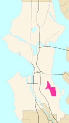
The Rainier Valley is a neighborhood in southeastern Seattle, Washington. It is located east of Beacon Hill; west of Mount Baker, Seward Park, and Leschi; south of the Central District and north of Rainier Beach. It is part of Seattle's South End.

<span class="mw-page-title-main">P-Patch</span> Allotment gardens in Seattle, Washington

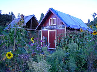
A P-Patch is a parcel of property used for gardening; the term is specific to Seattle, Washington. The "P" originally stood for "Picardo", after the family who owned Picardo Farm in Seattle's Wedgwood neighborhood, part of which became the original P-Patch.

<span class="mw-page-title-main">Rainier Beach, Seattle</span> Neighborhood in Seattle, Washington, U.S.

Rainier Beach is a set of neighborhoods in Seattle, Washington that are mostly residential. Also called Atlantic City, Rainier Beach can include Dunlap, Pritchard Island, and Rainier View neighborhoods.

<span class="mw-page-title-main">Neighborhoods in Spokane, Washington</span>

Neighborhoods in Spokane, Washington are officially grouped by the Spokane City Council into three main city council districts: 1, 2, and 3. Each city council district contains multiple, official neighborhoods that are recognized with a neighborhood council. Informally, neighborhoods are colloquially grouped by local geographical, geological, cultural, or historical features The list of neighborhoods below is organized based on the official designations by the City of Spokane. Unofficial neighborhoods and districts are listed within the official neighborhood in which they are located.

<span class="mw-page-title-main">Genesee Park (Seattle)</span>

Genesee Park is a 57.7-acre (0.234 km2) park in the Rainier Valley neighborhood of Seattle, Washington. A waterway, Wetmore Slough, before the lowering of Lake Washington by nine feet in 1917 as part of the construction of the Lake Washington Ship Canal, it was purchased by the city in 1947 and used as a dump until 1963. Development of the park began in 1968. It hosts the hydroplane races and aerobatics air show during the annual Seafair, in July–August.

<span class="mw-page-title-main">Othello station</span> Light rail station in Seattle, Washington

Othello station is a light rail station located in Seattle, Washington. It is situated between the Rainier Beach and Columbia City stations on the 1 Line, which runs from Angle Lake through Seattle-Tacoma International Airport to Downtown Seattle and the University of Washington as part of the Link light rail system. The station consists of two at-grade side platforms between South Othello Street and South Myrtle Street in the median of Martin Luther King Jr. Way South in the NewHolly neighborhood, part of Seattle's Rainier Valley.

<span class="mw-page-title-main">Columbia City station</span> Light rail station in Seattle, Washington

Columbia City station is a light rail station located in Seattle, Washington. It is situated between the Othello and Mount Baker stations on the 1 Line, which runs from Seattle–Tacoma International Airport to Downtown Seattle and the University of Washington as part of the Link light rail system. The station consists of two at-grade side platforms between South Alaska Street and South Edmunds Street in the median of Martin Luther King Jr. Way South in the Columbia City neighborhood, part of Seattle's Rainier Valley.

<span class="mw-page-title-main">Mount Baker station</span> Light rail station in Seattle, Washington

Mount Baker station is a light rail station located in Seattle, Washington. It is situated between the Columbia City and Beacon Hill stations on the 1 Line, which runs from Seattle–Tacoma International Airport to Downtown Seattle, the University of Washington, and Northgate as part of the Link light rail system. The elevated station consists of two side platforms located west of the intersection of Rainier Avenue and Martin Luther King Jr. Way in the Mount Baker neighborhood, part of Seattle's Rainier Valley.

<span class="mw-page-title-main">Vancouver, Washington</span> City in the U.S. state of Washington

Vancouver is a city on the north bank of the Columbia River in the U.S. state of Washington, located in Clark County. Founded in 1825 and incorporated in 1857, Vancouver had a population of 190,915 as of the 2020 census, making it the fourth-most populous city in Washington state. Vancouver is the seat of government of Clark County and forms part of the Portland-Vancouver metropolitan area, the 25th-largest metropolitan area in the United States. Originally established in 1825 around Fort Vancouver, a fur-trading outpost, the city is located on the Washington–Oregon border along the Columbia River, directly north of Portland.

<span class="mw-page-title-main">Hillman City, Seattle</span>

Hillman City is a primarily residential neighborhood in southeastern Seattle, Washington, located in the Rainier Valley and centered about a half mile south of the Columbia City neighborhood. It was annexed by Seattle in January 1907, along with the rest of the town of Southeast Seattle.

<span class="mw-page-title-main">Architecture of Seattle</span>

The architecture of Seattle, Washington, the largest city in the Pacific Northwest region of the U.S., features elements that predate the arrival of the area's first settlers of European ancestry in the mid-19th century, and has reflected and influenced numerous architectural styles over time. As of the early 21st century, a major construction boom continues to redefine the city's downtown area as well as neighborhoods such as Capitol Hill, Ballard and, perhaps most dramatically, South Lake Union.

References

  1. "Annexed Cities".
  2. "King County Assessors Office - Analytics".
  3. "Southeast Seattle ZIP Code 98118: Neighborhood of Nations". HistoryLink.org- the Free Online Encyclopedia of Washington State History. Retrieved 2016-06-12.
  4. 1 2 3 4 Cassandra Tate, Seattle Neighborhoods: Columbia City -- Thumbnail History, HistoryLink, June 2, 2001. Accessed 24 December 2007.
  5. 1 2 Cassandra Tate, City of Seattle annexes Columbia City on May 3, 1907 [ permanent dead link ], HistoryLink, May 30, 2001. Accessed 24 December 2007.
  6. "Columbia - CityArchives | seattle.gov". www.seattle.gov. Retrieved 2019-09-16.
  7. "Hitt's Fireworks: Lighting Up the Skies from Columbia City (Seattle)". HistoryLink.org- the Free Online Encyclopedia of Washington State History. Retrieved 2016-06-12.
  8. Columbia City Historic District, Seattle: A National Register of Historic Places Travel Itinerary, National Park Service. Accessed 24 December 2007.
  9. Columbia City Landmark District, Seattle Department of Neighborhoods. Accessed 24 December 2007.
  10. Excitement, Trepidation in Columbia City | Slog | The Stranger | Seattle's Only Newspaper
  11. "Forum Category - Columbia Citizens public input". columbiacitizens.net. Retrieved 2019-09-16.

47°33′39″N122°17′13″W / 47.5607°N 122.2870°W / 47.5607; -122.2870