
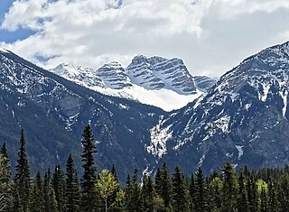
Mount Robson is the most prominent mountain in North America's Rocky Mountain range; it is also the highest point in the Canadian Rockies. The mountain is located entirely within Mount Robson Provincial Park of British Columbia, and is part of the Rainbow Range. Mount Robson is the second highest peak entirely in British Columbia, behind Mount Waddington in the Coast Range. The south face of Mount Robson is clearly visible from the Yellowhead Highway, and is commonly photographed along this route.

Mount Steele is the fifth-highest mountain in Canada and either the tenth- or eleventh-highest peak in North America. Its exact elevation is uncertain. Commonly-quoted figures are 5,073 metres (16,644 ft) and 5,020 metres (16,470 ft). A lower southeast peak of Mt. Steele stands at 4,300 m (14,100 ft).
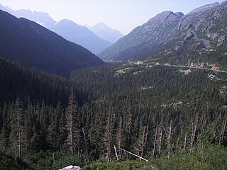
White Pass, also known as the Dead Horse Trail, is a mountain pass through the Boundary Ranges of the Coast Mountains on the border of the U.S. state of Alaska and the province of British Columbia, Canada. It leads from Skagway, Alaska, to the chain of lakes at the headwaters of the Yukon River.
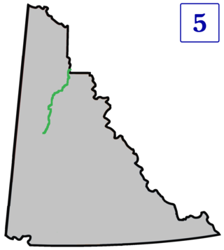
The Dempster Highway, also referred to as Yukon Highway 5 and Northwest Territories Highway 8, is a highway in Canada that connects the Klondike Highway in Yukon to Inuvik, Northwest Territories on the Mackenzie River delta. The highway crosses the Peel and the Mackenzie rivers using a combination of seasonal ferry services and ice bridges. Year-round road access from Inuvik to Tuktoyaktuk opened in November 2017, with the completion of the Inuvik–Tuktoyaktuk Highway, creating the first all-weather road route connecting the Canadian road network with the Arctic Ocean.

The Misty Range is a mountain range of the Canadian Rockies located east of the Bighorn Highway within Kananaskis Country, Canada.

Mount Rae is a mountain located on the eastern side of Highway 40 between Elbow Pass and the Ptarmigan Cirque in the Canadian Rockies of Alberta. Mount Rae was named after John Rae, explorer of Northern Canada, in 1859.
Mount Frank Rae is the highest mountain of the Ogilvie Mountains in central Yukon, Canada, located 62 km (39 mi) northeast of Dawson City.

The Mount Edziza volcanic complex is a group of volcanoes and associated lava flows in northwestern British Columbia, Canada. Located on the Tahltan Highland, it is 40 kilometres southeast of Telegraph Creek and 85 kilometres southwest of Dease Lake. The complex encompasses a broad, steep-sided lava plateau that extends over 1,000 square kilometres. Its highest summit is 2,786 metres in elevation, making the MEVC the highest of four large complexes in an extensive north–south trending volcanic region. It is obscured by an ice cap characterized by several outlet glaciers that stretch out to lower altitudes.
The Centennial Range is a sub-range of the Saint Elias Mountains. It is located inside Kluane National Park and Reserve in the far west of Yukon Territory in Canada. It consists of fourteen major peaks, and was named for Canada's Centennial in 1967. Its peaks bear the names of Canada's provinces and territories, with the exception of Nunavut, which was not a territory at the time. The tallest point is Centennial Peak. Nine of the peaks were climbed as part of the Yukon Alpine Centennial Expedition, part of the 1967 celebrations.

Mount Worthington is a 2,168-metre (7,113-foot) mountain summit in the Auriol Range of the Saint Elias Mountains, in Kluane National Park of Yukon, Canada. The mountain is situated above the shores of Kathleen Lake, 7.2 km (4 mi) northwest of Kings Throne Peak across the lake, and 19 km (12 mi) south-southeast of Haines Junction, Yukon. The mountain can be seen from the Haines Highway as it prominently rises 1,570-metre (5,150-foot) above the lake. The mountain's name was officially adopted August 12, 1980, by the Geographical Names Board of Canada. Based on the Köppen climate classification, Mount Worthington is located in a subarctic climate with long, cold, snowy winters, and mild summers.
Mount Decoeli is a 2,332-metre (7,651-foot) pyramidal peak located in the Kluane Ranges of the Saint Elias Mountains in Yukon, Canada. The mountain is situated 23 km (14 mi) northwest of Haines Junction, 21.4 km (13 mi) east of Mount Cairnes, and can be seen from the Alaska Highway midway between the two. Its nearest higher peak is Mount Archibald, 6 km (3.7 mi) to the south. The mountain's name was officially adopted August 12, 1980, by the Geographical Names Board of Canada. James J. McArthur was a Canadian surveyor and mountaineer who undertook extensive surveying in the Yukon during his later years. In 1908 he made the first ascent of Williams Peak accompanied by Edmond Treau de Coeli (1873–1963). Decoeli is pronounced deh-coh-lie. To the Southern Tutchone people, the mountain is known as Nàday Gän, meaning Dried Lynx Mountain.

Mount Archibald is a prominent 2,588-metre (8,491-foot) mountain summit located in the Kluane Ranges of the Saint Elias Mountains in Yukon, Canada. The mountain is situated 21 km (13 mi) west of Haines Junction, 5.9 km (4 mi) south of Mount Decoeli, and 27 km (17 mi) east-southeast of Mount Cairnes, which is the nearest higher peak. Set on the boundary line of Kluane National Park, Archibald can be seen from the Alaska Highway, weather permitting. The mountain was named after Edgar Archibald (1885-1968), a Canadian agricultural scientist. The mountain's name was officially adopted August 12, 1980, by the Geographical Names Board of Canada. On a clear day, the summit offers views deep into Kluane National Park of giants such as Mt. Logan, Mt. Vancouver, and Mt. Kennedy.

Mount Martha Black, elevation 2,512-metre (8,241-foot), is the highest point in the Auriol Range of the Saint Elias Mountains in Yukon, Canada. The multi-summit massif is situated 11 km (7 mi) southwest of Haines Junction, 16 km (10 mi) northwest of Mount Worthington, and 18.6 km (12 mi) southeast of Mount Archibald, which is the nearest higher peak. Set within Kluane National Park, Mount Martha Black can be seen from the Alaska Highway, weather permitting. The mountain was named after Martha Black (1866-1957), the second woman elected to the House of Commons of Canada. The mountain's name was officially adopted August 12, 1980, by the Geographical Names Board of Canada.

The Flathead Range is a mountain range of the Canadian Rockies in Alberta and British Columbia, Canada. It is located on the Continental Divide, east of Fernie, in the Kootenay Land District. It stretches 27 km (17 mi) lengthwise north–south from Crowsnest Pass to North Kootenay Pass. The range's toponym was officially adopted on 30 June 1912 by the Geographic Board of Canada, and was named in association with the Flathead River.
Overlander Mountain is a summit in British Columbia, Canada.

Klapperhorn Mountain is a summit in British Columbia, Canada.
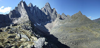
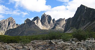
Tombstone Mountain is a mountain in Yukon, Canada.
Mount Monolith is a mountain in Yukon, Canada.
Mount Ogilvie is a 7,867-foot-elevation (2,398-meter) mountain summit located on, and in part defining, the international border between Alaska, United States, and British Columbia, Canada.


