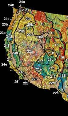
The precise boundaries of this cordillera and its subregions, as well as the names of its various features, may differ depending on the definitions in each country or jurisdiction, and also depending on the scientific field; this cordillera is a particularly prominent subject in the scientific field of physical geography.[3][4]
The North American Cordillera extends from the U.S. state of Alaska to the southern border of Mexico, and includes some of the highest peaks on the continent.[5] Its mountain ranges generally run north-to-south along three main belts: the Pacific Coast Ranges in the west, the Nevadan belt in the middle (including the Sierra Nevada), and the Laramide belt in the east (including the Rocky Mountains and the Black Hills).[6][7][8][9]
These three orogenic belts (also called "orogens") arose due to the engagement of tectonic plates which deformed the Earth's lithosphere (crust and uppermost mantle). For example, the Laramide orogeny changed the topography of the central Rocky Mountains and adjoining Laramide regions (from central Montana to central New Mexico) during the Late Cretaceous 80 million years ago.[10] Prior to this time the Rocky Mountain region was occupied by a broad basin. Further topographical evolution occurred during the Eocene (55–50million years ago) and Oligocene (34–23million years ago), but since that time, the region has been relatively stable.[11][12][13][14] Generally speaking, it will be convenient here to consider these three belts going west to east, and north to south.
In Alaska, south of the Interior Plains area, is the Rocky Mountain System, then the Intermontane Basins and Ranges, and in the southern part of the state are the Pacific Mountains and Valleys.[15] In the Alaska panhandle, the mainland mountain ranges and offshore islands (the Alexander Archipelago) are extensions of respective ranges further south.[16]
In Canada, the North American Cordillera is usually divided into three physiographic regions: the western system, the interior system, and the eastern system.[17] The western system includes the Coast Mountains, the interior system includes the Columbia Mountains, and the eastern system includes the Canadian Rockies.[3]
At its midsection between San Francisco, California, and Denver, Colorado, the North American Cordillera is about 1,000 miles (1,600km) wide, and its physiographic provinces at this midpoint are as follows, going from west to east: the Pacific Coast Ranges, the Central Valley, the Sierra Nevada, the Basin and Range Province (forming many narrow ranges and valleys), the Colorado Plateau, and the Rocky Mountains.[5] In the United States, another major feature of the Cordillera is the Columbia Plateau, located north of California between the Cascade Range, the Sierra Nevada, and the Rocky Mountains.
The Nevadan belt runs up and down the middle of the North American Cordillera. Therefore, the intermontane areas of the cordillera can be divided up into the areas east of the Nevadan belt, and those west of the Nevadan belt.
The Pacific Coast Ranges, comprising the Pacific Coast Belt, parallel the North American Pacific Coast, and comprise several mountain systems. Along the British Columbia and Alaska coasts, the mountains intermix with the sea in a complex maze of fjords, with thousands of islands. Off the Southern California coast, the Channel Islandsarchipelago of the Santa Monica Mountains extends for 160 miles (260km).
The terrain of the main spine of the Coast Mountains is typified by heavy glaciation, including several very large icefields of varying elevation. Of the three subdivisions, the Pacific Ranges are the highest and are crowned by Mount Waddington, while the Boundary Ranges contain the largest icefields, the Juneau Icefield being the largest. The Kitimat Ranges are lower and less glacier-covered than either of the other two groupings, but are extremely rugged and dense.
South of the Olympics lies the Chehalis River valley representing a break in elevation and drainages, followed by the Willapa Hills. The highest peak in the Willapa Hills is Boistfort Peak with an elevation of 3,113 feet (949m).[29] This region represents the lowest of the upland areas in the Pacific Coast Ranges.
The Columbia Mountains are classified as being in Canada's interior system, rather than its eastern system.[32] However, the Columbia Mountains are an extension of mountains in the United States that are considered part of the Rocky Mountains, and therefore the Columbia Mountains are often treated as being part of the Rockies.[33]
The Selkirks and Purcells lie entirely within the basin of the Columbia River, while the Monashees lie to the river's west on its southward course from its Big Bend and are flanked on the west by the basin of the Thompson and Okanagan Rivers. There are many named subranges of all four subgroupings, particularly in the Selkirks and Monashees. The southward extension of the Selkirks, Purcells and Monashees into the United States are reckoned to be part of the Rocky Mountains and the designation Columbia Mountains is not used there (the Purcells, also, go by the name "Percell Mountains" in the United States). The Salish and Cabinet Mountains south of the Kootenai River are essentially part of the same landform, but are officially designated part of the Rocky Mountains in the United States.
To the west of the Monashees and Cariboos, there are three intermediary upland areas which are transitional between the mountain ranges and the plateaus flanking the Fraser and Thompson Rivers. These Quesnel, Shuswap, and Okanagan Highlands are sometimes considered as being part of the neighbouring ranges rather than the plateaus and are often spoken of that way locally but are formally designated as being part of the Interior Plateau. The southernmost extends into Washington, where it is named by the American spelling Okanogan Highland (and was the first-named of these groupings).[32]
Cascade–Sierra Mountains in contiguous U.S.
The Cascade Range (called the Cascade Mountains in Canada) extends from northern California in the United States to British Columbia, Canada. It consists of non-volcanic and volcanic mountains: all of the known historic eruptions in the contiguous United States have been from the volcanoes of the Cascade Volcanic Arc. The highest peak in the Cascade Range is Mount Rainier (14,409 feet (4,392m)), a stratovolcano. The small portion of the Cascade Range in Canada is called the Cascade Mountains or Canadian Cascades, and in its southwestern area is similar in terrain to the area north of Glacier Peak, known as the North Cascades, and its northern and eastern extremities verge on the Thompson Plateau in a less rugged fashion than in most other parts of the range. The North Cascades are very different in character from the series of high volcanic stratovolcanoes from Rainier southwards to Mount Shasta and Lassen Peak, and are more severely alpine and steeply rugged, particularly the Skagit Range. Inland portions of the range are dryland and plateau-like in character, such as the Okanagan Range, which lies along the Cascades' northeastern margin, separated by the Similkameen River.
The Sierra Nevada forms an inland mountain spine of northern California, extending from the terminus of the Cascade Range south of Lassen Peak southwards along the east flank of the Central Valley of California to the Transverse Ranges, forming a mountain region of complex terrain and varied geology which separates the Central Valley from the Great Basin to the east. The mean height of the mountain summits in the Sierra Nevada gradually increases from north to south, culminating at Mount Whitney (14,505 feet (4,421m)), the highest point in the contiguous United States. From east to west, the Sierra is wedge-shaped: the west slope gradually rises and the east slope forms a steep escarpment, particularly so in the southern portion.
The northern Sierra surface rocks are predominantly volcanic, while the southern Sierra granitic batholith has been sculpted by glaciers into dramatic U-shaped valleys and thin ridges called arêtes.
Sierra Madre Occidental in Mexico
The Sierra Madre Occidental mountain range is a southern extension of the Sierra Nevada.[34] The range extends from near the Arizona border down to the Sierra Madre del Sur, along the western mainland of Mexico. The high plateau that is formed by the range is cut by deep river valleys.
Laramide Belt
The Laramide belt is on the side of the North American Cordillera most distant from the Pacific Coast Ranges. It is named for the Laramie Mountains of eastern Wyoming (in turn named for Jacques La Ramee, a trapper who disappeared in the Laramie Mountains in 1820 and was never heard from again).[35]
Alaska and Eastern System of Canada
The Brooks Range in Alaska
The Brooks Range includes the northernmost of the major mountain systems of the North American Cordillera, and extends along an east–west axis across northern Alaska from near the northern opening of the Bering Strait to the northern Yukon Territory. Major subranges include the British Mountains and Richardson Mountains, towards their eastern end, and at their farthest west is the De Long Mountains. The Brooks Range forms the northern flank of the lower Yukon River basin, separating it from Alaska's North Slope region, facing the Beaufort Sea. The Brooks Range is considered part of (or an extension of) the Rockies.[36][37][38] South of the Brooks Range are the Mackenzie Mountains and the Canadian Rockies.
The Sierra Madre Oriental mountains in eastern Mexico are a southern extension of the Rocky Mountains.[38][39] The Sierra Madre Oriental spans about 1,000km (600 miles). Mexico's Gulf Coastal Plain lies to the east of the range, between the mountains and the Gulf of Mexico coast. The Mexican Plateau lies to the west of the range.
Intermontane areas seaward from the Nevadan belt
The Nevadan belt runs down the middle of the North American Cordillera. Therefore, the intermontane areas can be divided up into the areas east of the Nevadan belt, and those west of the Nevadan belt.
California's Central Valley is a large, flat valley that dominates the central portion of California, stretching inland and parallel to the Pacific Ocean coast. Its northern half is referred to as the Sacramento Valley, and its southern half as the San Joaquin Valley. The two-halves meet at the huge Sacramento-San Joaquin River Delta of the Sacramento and San Joaquin Rivers, which along with their tributaries drain the majority of the valley and flow into San Francisco Bay. The Central Valley covers an area of approximately 22,500 square miles (58,000km2), making it slightly smaller than the state of West Virginia and about 13.7% of California's total area. The Central Valley is 40 to 60 miles (60 to 100km) wide, with the Sierra Nevada to the east and the Coast Ranges to the west.
The Gulf of California is a body of water that separates the Peninsular Ranges from the Sierra Madre Occidental on the Mexican mainland. The Gulf of California is 1,126km (700 miles) long and 48 to 241km (30 to 150 miles) wide, with an area of 177,000km2 (68,000sqmi), a mean depth of 818.08m (2,684.0ft), and a volume of 145,000km3 (35,000cumi).[44]
For convenience the Rocky Mountain Trench may be divided into northern and southern sections. The dividing point reflects the separation of north and easterly flows to the Arctic Ocean versus south and westerly flows to the Pacific Ocean. A break in the valley system at around 54°N near Prince George, British Columbia may be used for this purpose. There are three main mountain ranges in the Canadian area named the Rocky Mountains, the Columbia Mountains, and the Coast Mountains.
Portion in contiguous U.S.
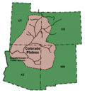
Colorado PlateauBasin & Range Province (indicated in blue)
The Colorado Plateau is an area of high desert located in Arizona, New Mexico, Colorado, and Utah, bisected by the Colorado River which flows westward through the southern part, and the Green River which flows south from the northernmost part of the plateau. The Green is a tributary of the Colorado, the confluence being west of Moab, Utah in Canyonlands National Park.[48]
A low east–west mountain range in the state of Zacatecas divides the plateau into northern and southern sections. These two sections, called the Northern Plateau (Spanish: Mesa del Norte) and Central Plateau (Spanish: Mesa Central), are now generally regarded by geographers as sections of one plateau.
↑R. Saager & F. Bianconi (1971). "The Mount Nansen gold–silver deposit, Yukon territory, Canada". Mineralium Deposita. 6 (3). doi:10.1007/BF00208030. S2CID129092271.
↑D. S. Cowan (1985). "Structural styles in Mesozoic and Cenozoic melanges in the Western Cordillera of North America". Geological Society of America Bulletin. 96 (4): 451. doi:10.1130/0016-7606(1985)96<451:SSIMAC>2.0.CO;2.
↑T. O. Tobisch; S. R. Paterson; S. Longiaru; T. Bhattacharyya (1987). "Extent of the Nevadan orogeny, central Sierra Nevada, California". Geology. 15 (2): 132. doi:10.1130/0091-7613(1987)15<132:EOTNOC>2.0.CO;2.
↑W. R. Dickinson; M. A. Klute; M. J. Hayes; S. U. Janecke; E. R. Lundin; M. A. McKittrick & M. D. Olivares (1988). "Paleogeographic and paleotectonic setting of Laramide sedimentary basins in the central Rocky Mountain region". Geological Society of America Bulletin. 100 (7): 1023. doi:10.1130/0016-7606(1988)100<1023:PAPSOL>2.3.CO;2.
↑J. A. Wolfe; C. E. Forest & P. Molnar (1998). "Paleobotanical evidence of Eocene and Oligocene paleoaltitudes in midlatitude western North America". Geological Society of America Bulletin. 110 (5): 664. doi:10.1130/0016-7606(1998)110<0664:PEOEAO>2.3.CO;2.
↑D. Alt and D. Hyndman. (1995). Northwest Exposures: A Geological Story of the North West. Mountain Press Publishing Company, Missoula, Montana
↑S. Brunsfeld, J. Sullivan, D. Soltis, and P. Sotis (2001). "Comparative phylogeography of north-western north america: A synthesis"Archived June 15, 2011, at the Wayback Machine . In: Silverton, J., Antonovics, J. (Eds.), Integrating Ecology and Evolution in a Spatial Context. The 14th Special Symposium of the British Ecological Society. British Ecolological Society, Blackwell Science Ltd., Ch. 15, pp. 319–339.
↑The Geography of Alaska: Physical GeographyArchived May 23, 2011, at the Wayback Machine , Alaska Humanities Forum: "At a very general level, Alaska is part of four general physiographic regions, the Interior Plains, Rocky Mountains, Intermontane Basins and Ranges, and the Pacific Mountains and Valleys".
↑Wheeler, J. and Kostbade, J. World Regional Geography (Saunders College Publishing 1990): "The mainland ranges of the panhandle are a northward extension of the cascade range and the British Columbia Coastal ranges, while the mountainous offshore islands are an extension of the Coast Ranges of the Pacific Northwest and the islands of British Columbia."
12Encyclopedia Americana: the International Reference Work, Volume 18: "Sierra Madre del Sur. — This sierra, which crosses the states of Colima, Michoacan, Guerrero, and Oaxaca, is the continuation of the Sierra de Baja California and the other mountain ranges linked with it." (Americana Corporation 1961).
↑Hultén, Eric. Flora of Alaska and Neighboring Territories: A Manual of the Vascular Plants, p. xiv (Stanford University Press, 1968).
↑Stefoff, Rebecca. Alaska, p. 14 (Marshall Cavendish, 2006).
↑Parsons, M. and Quinn, O. "Insular and Coastal Mountains, Interior MountainsArchived October 10, 2012, at the Wayback Machine ", Canadian Ministry of Environment: "Interior Mountains comprising the Columbia Mountains of the southern interior and the Omineca, Cassiar, Skeena and Hazelton Mountains of the northern interior."
↑Merrill, Tim et al. Mexico: A Country Study, p. 80 (Library of Congress, Federal Research Division, Claitors Pub Div. 2005): "The Sierra Madre Occidental on the west is a continuation of California's Sierra Nevada (with a break in southeastern California and extreme northern Mexico)…."
↑Thiem, Jon. Rabbit Creek Country: Three Ranching Lives in the Heart of the Mountain West, p. 143 (UNM Press, 2008).
This page is based on this Wikipedia article Text is available under the CC BY-SA 4.0 license; additional terms may apply. Images, videos and audio are available under their respective licenses.