
The Canadian Rockies or Canadian Rocky Mountains, comprising both the Alberta Rockies and the British Columbian Rockies, is the Canadian segment of the North American Rocky Mountains. It is the easternmost part of the Canadian Cordillera, which is the northern segment of the North American Cordillera, the expansive system of interconnected mountain ranges between the Interior Plains and the Pacific Coast that runs northwest–southeast from central Alaska to the Isthmus of Tehuantepec in Mexico.

The Mackenzie Mountains are a Canadian mountain range forming part of the Yukon–Northwest Territories boundary between the Liard and Peel rivers. The range is named in honour of Canada's second prime minister, Alexander Mackenzie. Nahanni National Park Reserve and Nááts'ihch'oh National Park Reserve are in the Mackenzie Mountains.

Yukon is in the northwestern corner of Canada and is bordered by Alaska, British Columbia and the Northwest Territories. The sparsely populated territory abounds with natural scenery, snowmelt lakes and perennial white-capped mountains, including many of Canada's highest mountains. The territory's climate is Arctic in territory north of Old Crow, subarctic in the region, between Whitehorse and Old Crow, and humid continental climate south of Whitehorse and in areas close to the British Columbia border. Most of the territory is boreal forest with tundra being the main vegetation zone only in the extreme north and at high elevations.
The Bonnet Plume River is one of Yukon's better-known rivers. It flows south to north, from a mountain lake source in the Bonnet Plume Range in the Mackenzie Mountains through several mountain ranges to its confluence with the Peel. It is very popular with outdoor enthusiasts as a canoe, kayak or rafting trip. There is large section of whitewater on the river where it passes through a rockslide canyon.

The Tagish Highland is an upland area on the inland side of the northernmost Boundary Ranges of the Coast Mountains, spanning far northwestern British Columbia from Atlin Lake to the area of the pass at Champagne, Yukon between the Alsek and Yukon Rivers. In some classification systems, and in local terminology, the Tagish Highland is considered to be part of the Boundary Ranges, as is the neighbouring Tahltan Highland to its south. As classified by the Canadian Mountain Encyclopedia per S. Holland, the Tagish Highland is part of the system unofficially described as the Interior Mountains.

The Richardson Mountains are a mountain range located west of the mouth of the Mackenzie River in northern Yukon, Canada. They parallel the northernmost part of the boundary between Yukon and Northwest Territories.

The Cassiar Mountains are the most northerly group of the Northern Interior Mountains in the Canadian province of British Columbia and also extend slightly into the southernmost Yukon Territory. They lie north and west of the Omineca Mountains, west of the northernmost Rockies and the Rocky Mountain Trench, north of the Hazelton Mountains and east of the Boundary Ranges. They form a section of the Continental Divide, that, in this region, separates water drainage between the Arctic and Pacific Oceans. Physiographically, they are a section of the larger Yukon-Tanana Uplands province, which in turn are part of the larger Intermontane Plateaus physiographic division.
The Stikine Ranges are a group of mountain ranges and mountainous plateaus in northwestern British Columbia, Canada. They are the northernmost subdivision of the Cassiar Mountains and among the least explored and most undeveloped parts of the province.
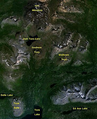
The Tuya Range is a mountain range in the Stikine Ranges of the Cassiar Mountains in the far north of the Canadian province of British Columbia, near its border with the Yukon Territory and to the southwest of Watson Lake, Yukon, which is the nearest major settlement.
Toozaza Peak is a tuya in the Stikine Ranges of the Cassiar Mountains in northern British Columbia, Canada, located in the Iverson Creek. Toozaza Peak is the summit of a north–south aligned ridge between the head of Toozaza Creek and the head of the Jennings River, just south of the Jennings' divide with the Little Rancheria River headwaters. The Little Rancheria and Toozaza Creek are part of the Liard, while the Jennings is part of the Yukon River drainage via Teslin Lake, and the peak therefore stands astride the line of the Continental Divide. It is part of the Tuya Volcanic Field, a volcanic field associated with the Stikine Volcanic Belt, part of the Northern Cordilleran Volcanic Province.

The Ogilvie Mountains are a mountain range in the Yukon Territory of northwestern Canada.
The Atsutla Range is a granitic mountain range on the Kawdy Plateau in northern British Columbia, Canada. The Atsutla Range lies south of the Yukon border in between Teslin Lake and the Stewart-Cassiar Highway, roughly 120 km (75 mi) north-northeast of Dease Lake.
The Yukon Ranges are a mountain range comprising the mountains in the southeastern part of the U.S. state of Alaska and most of the Yukon in Canada. Named after the Yukon, this range has area of 364,710 square kilometres (140,820 sq mi).
The Pelly Mountains are a mountain range in the Yukon, Canada. It has an area of 44,014 km2 (16,994 sq mi) and is a subrange of the Yukon Ranges which in turn form part of the Pacific Coast Ranges.
The Big Salmon Range is a remote mountain range in the Yukon, Canada. It has an area of 9001 km2 and is a subrange of the Pelly Mountains which in turn form part of the Yukon Ranges. Most of its peaks are unnamed.
The Saint Cyr Range is a remote mountain range in the Yukon, Canada. It has an area of 6224 km2 and is a subrange of the Pelly Mountains which in turn form part of the Yukon Ranges.
The Horseranch Range is a 40 km (25 mi) long north–south trending mountain range in northern British Columbia, Canada, located at the head of the Red River to the northwest of Deadwood Lake. Part of the Dease Plateau of either the Yukon Plateau or Cassiar Mountains system, it contains no glaciers and lies completely above tree line.
The Dezadeash Range is a mountain range in southern Yukon, Canada, located east of Haines Junction and south of the Alaska Highway. It has an area of 1,005 km2 (388 sq mi) and its appearance has a triangular shape. Although it can be considered to lie within the northern Boundary Ranges of the Coast Mountains, the Canadian Government consider the Dezadeash Range as part of the Yukon Plateau.

The Yukon Plateau is a plateau located in the Yukon Territory, comprising much of the central and southern Yukon Territory and the far northern part of British Columbia, Canada between Tagish Lake (W) and the Cassiar Mountains (E) and north of the Nakina River.
The British Mountains are a mountain range in Yukon Territory, Canada. It is generally defined as the section of the Brooks Range within Canada.
