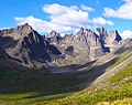
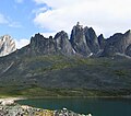
Mount Monolith

Last updated
Mount Monolith
Mt. Monolith.jpg
Summit centered, west aspect
Highest point
Elevation 2,165 m (7,103 ft) [1]
Prominence 444 m (1,457 ft) [2]
Parent peak Tombstone Mountain [3]
Isolation 4.43 km (2.75 mi) [2]
Coordinates 64°25′36″N138°31′35″W / 64.42667°N 138.52639°W / 64.42667; -138.52639 [4]
Naming
Etymology Monolith
Geography
Location map Yukon 2.png
Red triangle with thick white border.svg
Mount Monolith
Location in Yukon, Canada
Location Yukon, Canada
Protected area Tombstone Territorial Park [3]
Parent range Ogilvie Mountains [2]
Topo map NTS 116B7 Tombstone River
Geology
Age of rock Cretaceous
Type of rock Granite

Mount Monolith is a mountain in Yukon, Canada.

Description

Mount Monolith is a 2,165-metre-elevation (7,103-foot) summit located in the Ogilvie Mountains and within Tombstone Territorial Park. It ranks as the sixth-highest mountain in the Ogilvie Mountains. [2] Precipitation runoff from the remote peak drains into the Tombstone River and North Klondike River which are both part of the Yukon River watershed. [2] Topographic relief is significant as the summit rises 725 metres (2,380 feet) above the Tombstone River in less than two kilometres (1.2 mile). The nearest road is the Dempster Highway 11 km (7 mi) to the southeast, and the nearest town is Dawson, 60 km (37 mi) to the southwest. [4] Based on the Köppen climate classification, Mount Monolith is located in a subarctic climate zone with long, cold, winters, and short, mild summers. [5] Winter temperatures can drop below −40 °C with wind chill factors below −50 °C. The toponym was officially adopted on July 30, 1968, by the Geographical Names Board of Canada. [4]

Contents

See also

Related Research Articles

<span class="mw-page-title-main">Mount Cornwall</span> Mountain in Alberta, Canada

Mount Cornwall is a prominent 2,970-metre (9,740-foot) summit located between the Elbow River valley and Little Elbow River valley of Kananaskis Country in the Canadian Rockies of Alberta, Canada. The peak is visible from Highway 66, weather permitting. Mount Cornwall's nearest higher peak is Tombstone Mountain, 6.6 km (4.1 mi) to the southwest.

<span class="mw-page-title-main">Mount Indefatigable</span> Mountain in Alberta, Canada

Mount Indefatigable is a 2,667-metre (8,750-foot) mountain summit located in Peter Lougheed Provincial Park in the Canadian Rockies of Alberta, Canada. The peak is visible from Alberta Highway 40, and the Kananaskis Lakes area. Mount Indefatigable's nearest higher neighbor is Mount Invincible, 1.8 km (1.1 mi) to the northwest.

<span class="mw-page-title-main">Mount Maxwell</span> Summit of the Saint Elias Mountains in Kluane National Park of Yukon, Canada

Mount Maxwell is a 3,020-metre (9,910-foot) mountain summit of the Saint Elias Mountains in Kluane National Park of Yukon, Canada. The mountain is situated at the toe of the Kaskawulsh Glacier. The mountain cannot be seen from any roads, but can be seen from the Slims River valley. The nearest higher peak is Mount Leacock, 9.2 km (5.7 mi) to the south. The "Mt Maxwell" designation is misplaced five kilometres to the northeast of the actual summit on the topographic map. The mountain was named by John Oliver Wheeler, a Canadian geologist with the Geological Survey of Canada who climbed Maxwell in 1954. The Maxwell name was approved in 1960, and was made official in 1981 by the Geographical Names Board of Canada. However, it remains a mystery who Maxwell was. Based on the Köppen climate classification, Mount Maxwell is located in a subarctic climate with long, cold, snowy winters, and mild summers.

<span class="mw-page-title-main">Cinnamon Peak</span> Mountain summit in British Columbia, Canada

Cinnamon Peak is a 2,727-metre (8,947-foot) mountain summit located in the northwestern part of Mount Robson Provincial Park, in the Canadian Rockies of British Columbia, Canada. It is situated immediately north of the confluence of the Robson River and the Fraser River, and is visible from the Yellowhead Highway near the park's visitor centre. The peak was labelled "Little Grizzly" on Arthur Oliver Wheeler's 1911 topographic map of Mount Robson. He thought it appeared similar to Mount Grizzly in the Selkirk Mountains, but the name was later changed to Cinnamon, which is the coloration of the peak and the Cinnamon bear, which can be easily mistaken for a grizzly bear. "Little Grizzly" is a colloquial term for the black bear, Ursus americanus. Eastern populations are typically black in color, however western populations can be cinnamon colored. The mountain's toponym was officially adopted in 1951 by the Geographical Names Board of Canada. The nearest higher peak is Whitehorn Mountain, 6.0 km (3.7 mi) to the north.

<span class="mw-page-title-main">Alpha Mountain</span> Mountain in British Columbia, Canada

Alpha Mountain is a 2,302-metre (7,552-foot) summit located in the Tantalus Range, in Tantalus Provincial Park, in southwestern British Columbia, Canada. It is situated 14 km (8.7 mi) northwest of Squamish, and 4.6 km (2.9 mi) southeast of Mount Tantalus, which is the highest peak in the Tantalus Range. Its nearest higher peak is Serratus Mountain, 1.9 km (1.2 mi) to the west. The Serratus Glacier lies to the west of Alpha, unnamed glaciers lie on the northern and eastern slopes, and Lake Lovely Water lies below the south slope. Precipitation runoff from the peak drains into tributaries of the Squamish River.

<span class="mw-page-title-main">Mount Bayard</span> Mountain in Canada and the United States

Mount Bayard is a 1,999-metre (6,558 ft) glaciated mountain located in the Boundary Ranges on the international boundary line of Alaska and British Columbia. It is situated 22 kilometres (14 mi) north-northwest of Stewart, 10 km (6 mi) southeast of Mount White-Fraser, and 3.4 km (2 mi) east of Mount Lindeborg, which is its nearest higher peak. Precipitation runoff from the peak and meltwater from the Boundary and Salmon Glaciers that surround the peak drains into the Salmon River. Weather permitting, the mountain can be seen from the gravel Granduc Mine Road at Hyder, Alaska.

<span class="mw-page-title-main">Mount Cairnes</span> Mountain in Yukon, Canada

Mount Cairnes is a 2,810-metre (9,220-foot) mountain summit in the Saint Elias Mountains on the boundary line of Kluane National Park in Yukon, Canada. The mountain is situated 44 km (27 mi) west of Haines Junction, 18 km (11 mi) southeast of Kluane Lake, and can be seen from the Alaska Highway midway between the two. Its nearest higher peak is Mount Maxwell, 27.7 km (17.2 mi) to the southwest. The mountain's name was officially adopted February 3, 1981, by the Geographical Names Board of Canada. Clive Elmore Cairnes (1892–1954) was active with the Geological Survey of Canada as well as the Geographic Board of Canada until his retirement in 1953. He was related to noted geologist DeLorme Donaldson Cairnes (1879–1917), for whom this mountain is named.

Mount Decoeli is a 2,332-metre (7,651-foot) pyramidal peak located in the Kluane Ranges of the Saint Elias Mountains in Yukon, Canada. The mountain is situated 23 km (14 mi) northwest of Haines Junction, 21.4 km (13 mi) east of Mount Cairnes, and can be seen from the Alaska Highway midway between the two. Its nearest higher peak is Mount Archibald, 6 km (3.7 mi) to the south. The mountain's name was officially adopted August 12, 1980, by the Geographical Names Board of Canada. James J. McArthur was a Canadian surveyor and mountaineer who undertook extensive surveying in the Yukon during his later years. In 1908 he made the first ascent of Williams Peak accompanied by Edmond Treau de Coeli (1873–1963). Decoeli is pronounced deh-coh-lie. To the Southern Tutchone people, the mountain is known as Nàday Gän, meaning Dried Lynx Mountain.

<span class="mw-page-title-main">Mount Archibald</span>

Mount Archibald is a prominent 2,588-metre (8,491-foot) mountain summit located in the Kluane Ranges of the Saint Elias Mountains in Yukon, Canada. The mountain is situated 21 km (13 mi) west of Haines Junction, 5.9 km (4 mi) south of Mount Decoeli, and 27 km (17 mi) east-southeast of Mount Cairnes, which is the nearest higher peak. Set on the boundary line of Kluane National Park, Archibald can be seen from the Alaska Highway, weather permitting. The mountain was named after Edgar Archibald (1885-1968), a Canadian agricultural scientist. The mountain's name was officially adopted August 12, 1980, by the Geographical Names Board of Canada. On a clear day, the summit offers views deep into Kluane National Park of giants such as Mt. Logan, Mt. Vancouver, and Mt. Kennedy.

<span class="mw-page-title-main">Mount Martha Black</span>

Mount Martha Black, elevation 2,512-metre (8,241-foot), is the highest point in the Auriol Range of the Saint Elias Mountains in Yukon, Canada. The multi-summit massif is situated 11 km (7 mi) southwest of Haines Junction, 16 km (10 mi) northwest of Mount Worthington, and 18.6 km (12 mi) southeast of Mount Archibald, which is the nearest higher peak. Set within Kluane National Park, Mount Martha Black can be seen from the Alaska Highway, weather permitting. The mountain was named after Martha Black (1866-1957), the second woman elected to the House of Commons of Canada. The mountain's name was officially adopted August 12, 1980, by the Geographical Names Board of Canada.

<span class="mw-page-title-main">Mount Selwyn</span>

Mount Selwyn, is a 3,335-metre (10,942-foot) mountain summit located in Glacier National Park of British Columbia, Canada. It is part of the Selkirk Mountains range. The mountain is situated 60 km (37 mi) east-northeast of Revelstoke, and 35 km (22 mi) southwest of Golden. Its nearest higher peak is Mount Dawson, 1 km (0.62 mi) to the west. Originally named Deville in 1888 by mountaineer Rev. William S. Green, Mount Selwyn was renamed to honor Alfred Richard Cecil Selwyn (1824-1902), director of the Geological Survey of Canada, and President of the Royal Society of Canada. The mountain's name was officially adopted September 8, 1932, by the Geographical Names Board of Canada. The first ascent of the mountain was made in 1890 by Harold E. Forster, Harold Ward Topham, Harry Sinclair, and Samuel Yves.

<span class="mw-page-title-main">Grizzly Mountain (Canada)</span> Mountain in British Columbia, Canada

Grizzly Mountain is a 2,754-metre (9,035-foot) mountain summit located in Glacier National Park, in the Hermit Range of the Selkirk Mountains in British Columbia, Canada. Grizzly Mountain is situated 57 km (35 mi) northeast of Revelstoke, and 42 km (26 mi) west of Golden. It is also set 4 km (2.5 mi) north of Cheops Mountain, and 3 km (1.9 mi) west of Rogers Pass from which it can be seen from the Trans-Canada Highway. The closest peak to Grizzly is Ursus Minor Mountain, 1.27 km (0.79 mi) to the west-southwest, and its nearest higher peak is Mount Sifton, 2.35 km (1.46 mi) to the north. The first ascent of the mountain was made August 31, 1901, by John E. Bushnell, August S. Eggers, Karl Schuluneggar, and Friedrich Michel via the southeast couloir. The first ascent of the north ridge was made in 1921 by Neal Carter, Tom Fyles, and Don Munday. The class 5.2 west ridge was first climbed by Georgia Engelhard and Ernest Feuz in 1933. The mountain's name was adopted in 1906, then re-approved September 8, 1932, by the Geographical Names Board of Canada. It was so-named because of its proximity above Bear Creek, and in keeping with the bear theme of other nearby features such as Ursus Major Mountain, Ursus Minor Mountain, Bruins Pass, and Balu Pass.

<span class="mw-page-title-main">Mount Sifton</span> Mountain in the country of Canada

Mount Sifton is a 2,922-metre (9,587-foot) mountain summit located in Glacier National Park, in the Hermit Range of the Selkirk Mountains in British Columbia, Canada. Mount Sifton is situated 58 km (36 mi) northeast of Revelstoke, and 41 km (25 mi) west of Golden. It is also set 2.35 km (1.46 mi) north-northeast of Grizzly Mountain, and 4.5 km (2.8 mi) northwest of Rogers Pass from which it can be seen from the Trans-Canada Highway. The nearest higher peak is Mount Rogers, 2.17 km (1.35 mi) to the north-northeast. The first ascent of the mountain was made September 3, 1900, by Arthur Michael, Edward Feuz, and Friedrich Michel via the southeast ridge. The peak's name honors Sir Clifford Sifton (1861–1929), Canadian Minister of the Interior from 1896 through 1905. The mountain's toponym was adopted in 1906, then re-approved September 8, 1932, by the Geographical Names Board of Canada.

<span class="mw-page-title-main">Mount Cairnes (British Columbia)</span> Mountain in the country of Canada

Mount Cairnes is a 3,060-metre (10,039 ft) mountain summit located in the Freshfield Ranges of the Canadian Rockies in British Columbia, Canada. The mountain is situated 44 km (27 mi) north of Golden in the Blaeberry Valley, 5.5 km (3.4 mi) east-northeast of Mount Mummery, and 3 km (1.9 mi) from the Continental Divide. The mountain was named in 1917 after noted geologist Delorme Donaldson Cairnes (1879-1917) of the Geological Survey of Canada from 1905 through 1917. The mountain's name was officially adopted March 31, 1924, when approved by the Geographical Names Board of Canada. There is also another Mount Cairnes named for this same person located in Yukon, where he did much of his work.

<span class="mw-page-title-main">Mount Cooper (British Columbia)</span>

Mount Cooper is a prominent 3,094-metre (10,151 ft) glaciated mountain summit located in the Selkirk Mountains of southeast British Columbia, Canada. It is situated 36 km (22 mi) northwest of Kaslo, within Goat Range Provincial Park. Mt. Cooper is the highest peak in the Goat Range and Slocan Ranges, which are subsets of the Selkirks. The nearest higher peak is Truce Mountain, 33 km (21 mi) to the east-northeast. The first ascent of Mount Cooper was made August 10, 1962, by William Boulton, Terry Beck, Richard Hahn, Lorna Ream, Jack Steele, Edward Bouttin and Gary Johnson via the Spokane Glacier. This climbing party was from the Spokane Mountaineers organization. The mountain was named in association with Cooper Creek, which in turn was named after an 1880s Kaslo prospector and trapper. The mountain's name was officially adopted June 9, 1960, when approved by the Geographical Names Board of Canada. Prior to 1960 it was called Cooper Mountain.

<span class="mw-page-title-main">Sheep Mountain (Yukon)</span> Summit of the Saint Elias Mountains in Kluane National Park of Yukon, Canada

Sheep Mountain is a 1,953-metre (6,407-foot) mountain summit of the Saint Elias Mountains, in Kluane National Park of Yukon, Canada. It is known as Thechàl Dhâl by the Southern Tutchone people, meaning "Skin Scraper Mountain", referring to the thechàl, a flat stone scraper that was used to prepare animal hides. Sheep Mountain is habitat for Dall sheep, and was once a favorite sheep hunting area for the Southern Tutchone before the park was established. The mountain is a prominent landmark along the Alaska Highway, and topographic relief is significant as the summit rises 1,140 meters above the Thechàl Dhâl Visitor Centre at Kluane Lake in 2.5 kilometers. The mountain can be climbed via an 11 km (6.8 mi) loop which gains 1,310 meters of elevation, part of which is on the Sheep Creek Trail, one of the most popular hikes in Kluane Park. The route provides good opportunities to see Dall sheep, which the mountain is named for. The summit offers views up the Slims River valley to Mount Maxwell, south to Vulcan Mountain, and 2.4 km (1.5 mi) northwest to Mount Wallace, which is the nearest higher neighbor.

<span class="mw-page-title-main">Otter Mountain</span> Mountain in British Columbia, Canada

Otter Mountain is a prominent 2,693-metre (8,835-foot) glaciated summit located in the Coast Mountains of British Columbia, Canada. It is situated 16 kilometers northeast of Stewart, British Columbia, and the nearest higher peak is Mount Pattullo, 25.4 km (15.8 mi) to the north. Otter ranks as the 23rd most topographically prominent summit of Canada. Topographic relief is significant as the summit rises 2,380 meters above Bitter Creek Valley in 5 kilometers. This mountain's toponym was adopted as "Mount Otter" on 24 July 1945, and officially renamed Otter Mountain on 5 November 1953 by the Geographical Names Board of Canada. Precipitation runoff from the mountain drains west into Bitter Creek which is a tributary of the Bear River, or east to Nelson Creek which is part of the Nass River drainage basin, and all ultimately finds its way to the Inside Passage.

<span class="mw-page-title-main">Mount Cartier</span>

Mount Cartier is a 2,610-metre (8,563-foot) mountain summit located in British Columbia, Canada.

<span class="mw-page-title-main">Ulu Mountain</span>

Ulu Mountain is a mountain in Yukon, Canada.

<span class="mw-page-title-main">Tombstone Mountain (Yukon)</span>

Tombstone Mountain is a mountain in Yukon, Canada.

References

  1. "Mount Monolith". Bivouac.com. Retrieved 2024-01-22.
  2. 1 2 3 4 5 "Mount Monolith, Yukon Territory". Peakbagger.com. Retrieved 2024-01-22.
  3. 1 2 Mount Monolith, Peakvisor.com, Retrieved 2024-01-22.
  4. 1 2 3 "Mount Monolith". Geographical Names Data Base . Natural Resources Canada . Retrieved 2024-01-22.
  5. Peel, M. C.; Finlayson, B. L.; McMahon, T. A. (2007). "Updated world map of the Köppen−Geiger climate classification". Hydrol. Earth Syst. Sci. 11. ISSN   1027-5606.