Key Cave National Wildlife Refuge is a 1,060 acre (4.3km2) National Wildlife Refuge located in northwestern Alabama, along the Tennessee River downstream from Florence, Alabama. Additional purchases are under negotiation which will increase the size of the refuge to 1,800 acres (7.3km2).
National Wildlife RefugeSystem is a designation for certain protected areas of the United States managed by the United States Fish and Wildlife Service. The National Wildlife Refuge System is the system of public lands and waters set aside to conserve America's fish, wildlife, and plants. Since President Theodore Roosevelt designated Florida's Pelican Island National Wildlife Refuge as the first wildlife refuge in 1903, the system has grown to over 562 national wildlife refuges and 38 wetland management districts encompassing more than 150,000,000 acres (607,028 km2).
Alabama is a state in the southeastern region of the United States. It is bordered by Tennessee to the north, Georgia to the east, Florida and the Gulf of Mexico to the south, and Mississippi to the west. Alabama is the 30th largest by area and the 24th-most populous of the U.S. states. With a total of 1,500 miles (2,400 km) of inland waterways, Alabama has among the most of any state.
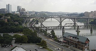
The Tennessee River is the largest tributary of the Ohio River. It is approximately 652 miles (1,049 km) long and is located in the southeastern United States in the Tennessee Valley. The river was once popularly known as the Cherokee River, among other names, as many of the Cherokee had their territory along its banks, especially in eastern Tennessee and northern Alabama. Its current name is derived from the Cherokee village Tanasi.
The Wheeler National Wildlife Refuge is a 35,000 acre (142 km2) National Wildlife Refuge located along the Tennessee River near Decatur, Alabama. Named after Major General Joseph Wheeler, it was established to provide a habitat for wintering and migrating birds in the eastern United States.
Decatur is a city in Morgan and Limestone counties in the State of Alabama. The city, nicknamed "The River City", is located in Northern Alabama on the banks of Wheeler Lake, along the Tennessee River. It is the largest city and county seat of Morgan County. The population in 2010 was 55,683.
Topography
Key Cave NWR
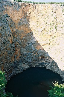
Two caves, Key Cave and Collier Cave, lie within the refuge, approximately 1.5 miles (2.4km) apart. Both caves are closed to the public. Each is on the northern shore of Pickwick Lake on the Tennessee River. The area also contains several sinkholes and cave systems, including a 38-acre (150,000m2)sinkhole lake. The sinkholes and cave systems provide a source of groundwater for the caves. The refuge is set up to minimize the pollution of this groundwater.
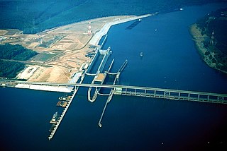
Pickwick Lake is the reservoir created by Pickwick Landing Dam as part of the Tennessee Valley Authority. The lake stretches from Pickwick Landing Dam to Wilson Dam.
A sinkhole, also known as a cenote, sink, sink-hole, swallet, swallow hole, or doline, is a depression or hole in the ground caused by some form of collapse of the surface layer. Most are caused by karst processes – for example, the chemical dissolution of carbonate rocks or suffosion processes. Sinkholes vary in size from 1 to 600 m both in diameter and depth, and vary in form from soil-lined bowls to bedrock-edged chasms. Sinkholes may form gradually or suddenly, and are found worldwide.
Groundwater is the water present beneath Earth's surface in soil pore spaces and in the fractures of rock formations. A unit of rock or an unconsolidated deposit is called an aquifer when it can yield a usable quantity of water. The depth at which soil pore spaces or fractures and voids in rock become completely saturated with water is called the water table. Groundwater is recharged from and eventually flows to the surface naturally; natural discharge often occurs at springs and seeps, and can form oases or wetlands. Groundwater is also often withdrawn for agricultural, municipal, and industrial use by constructing and operating extraction wells. The study of the distribution and movement of groundwater is hydrogeology, also called groundwater hydrology.
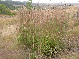
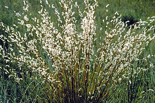
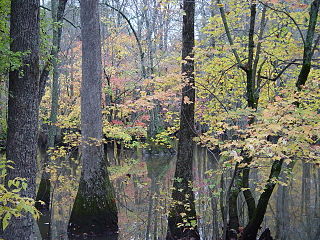
The land suffers from severe erosion due to the extensive farming in the area. A restoration of the land to native warm season grasses and mixed hardwoods is underway in order to protect the cave groundwater area. Approximately 338 acres (1.4km2) of the land is used for corn and soybean production under a Cooperative Farm Agreement. Fields of warm season grasses such as big bluestem (Andropogon gerardi), little bluestem (Schizachyrium scoparium), Indiangrass (Sorghastrum nutans), sideoats grama (Bouteloua curtipendula), switchgrass (Panicum virgatum), and eastern gamagrass (Tripsacum dactyloides) cover 260 acres (1.1km2) of land. 122 acres (0.49km2) of hardwood forest has been planted to help control the erosion. There are an additional 30 acres (120,000m2) of erosion drainages which are being converted to grassland or hedgerow habitat, 16 acres (65,000m2) being used as shallow water areas, and 256 acres (1.04km2) of hardwood forests consisting primarily of oak and hickory trees.
In earth science, erosion is the action of surface processes that removes soil, rock, or dissolved material from one location on the Earth's crust, and then transports it to another location. This natural process is caused by the dynamic activity of erosive agents, that is, water, ice (glaciers), snow, air (wind), plants, animals, and humans. In accordance with these agents, erosion is sometimes divided into water erosion, glacial erosion, snow erosion, wind (aeolic) erosion, zoogenic erosion, and anthropogenic erosion. The particulate breakdown of rock or soil into clastic sediment is referred to as physical or mechanical erosion; this contrasts with chemical erosion, where soil or rock material is removed from an area by its dissolving into a solvent, followed by the flow away of that solution. Eroded sediment or solutes may be transported just a few millimetres, or for thousands of kilometres.
Andropogon gerardi, known commonly as big bluestem, turkeyfoot, tall bluestem, and bluejoint, is a tall grass native to much of the Great Plains and grassland regions of central and eastern North America.
Schizachyrium scoparium, commonly known as little bluestem or beard grass, is a North American prairie grass native to most of the United States, except California, Nevada, and Oregon, and a small area north of the Canada–US border. It is most common in the Midwestern prairies. Little bluestem is a perennial bunchgrass and is prominent in tallgrass prairie, along with big bluestem (Andropogon gerardi), indiangrass (Sorghastrum nutans) and switchgrass (Panicum virgatum). It is a warm-season species, meaning it employs the C4 photosynthetic pathway.
History
Map of Key Cave NWR
The land of the Key Cave NWR area has historically been used for agricultural purposes, primarily in farming cotton. The area receives its name from William Key, who owned the land the refuge now contains as well as a plantation house on nearby private property. A slave cemetery called "Key Cemetery" is located on the refuge.
Cotton is a soft, fluffy staple fiber that grows in a boll, or protective case, around the seeds of the cotton plants of the genus Gossypium in the mallow family Malvaceae. The fiber is almost pure cellulose. Under natural conditions, the cotton bolls will increase the dispersal of the seeds.
In 1990, the Ozark Underground Laboratory tested the underground water table and determined that the area suffered from chemical pollution from nearby cotton, soybean, corn, and wheat farming operations. The Key Cave and Collier Cave share the same aquifer system which was being polluted as a result of the farming operations.
The water table is the upper surface of the zone of saturation. The zone of saturation is where the pores and fractures of the ground are saturated with water.
Surface runoff is the flow of water that occurs when excess stormwater, meltwater, or other sources flows over the Earth's surface. This might occur because soil is saturated to full capacity, because rain arrives more quickly than soil can absorb it, or because impervious areas send their runoff to surrounding soil that cannot absorb all of it. Surface runoff is a major component of the water cycle. It is the primary agent in soil erosion by water.
An aquifer is an underground layer of water-bearing permeable rock, rock fractures or unconsolidated materials. Groundwater can be extracted using a water well. The study of water flow in aquifers and the characterization of aquifers is called hydrogeology. Related terms include aquitard, which is a bed of low permeability along an aquifer, and aquiclude, which is a solid, impermeable area underlying or overlying an aquifer. If the impermeable area overlies the aquifer, pressure could cause it to become a confined aquifer.
In 1992, the Monsanto Company sold the land in the highest hazard risk area to The Conservation Fund. This land was later sold to the U.S. Fish and Wildlife Service which established the Key Cave NWR on January 3, 1997.
Wildlife
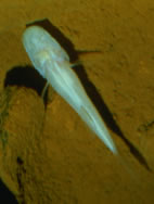
Alabama cavefish
Key Cave is a critical habitat for the endangered Alabama cavefish (Speoplatyrhinus poulsoni). Only 130 specimens have been observed over the 36 excursions to Key Cave between 1967 and 1998. The refuge also provides protection for approximately 40,000 endangered gray bats (Myotis grisescens). The cave is also home to two species of endangered crayfish: Phantom cave crayfish (Procambarus pecki) and Cambarus jonesi.
The refuge has 2.5 miles (4.0km) of trails for hiking and cycling. Key Cave is not open to the public, but nearby viewing platforms facilitate the viewing of the bats during the summer. This is the #9 site on the North Alabama Birding Trail.
This page is based on this Wikipedia article Text is available under the CC BY-SA 4.0 license; additional terms may apply. Images, videos and audio are available under their respective licenses.
Related Research Articles
The Cache River National Wildlife Refuge is a 68,993 acre (223 km2) (2014) wildlife refuge in the state of Arkansas managed by the United States Fish and Wildlife Service (FWS#. The refuge is one of the Ramsar wetlands of international importance under the Ramsar Convention signed in 1971. It is one of the most important wintering area for ducks and the largest remaining tract of contiguous bottomland hardwood forest on the North American continent. In 2005, a possible sighting of the ivory-billed woodpecker, thought to be extinct, brought attention to the refuge.
The Bald Knob National Wildlife Refuge is a 15,022 acres (60.79 km2) (2014) wildlife refuge located in White County, Arkansas about two miles south of the town of Bald Knob. The refuge is managed by the United States Fish and Wildlife Service. The refuge features large numbers of migratory waterfowl and bald eagles during the winter months.
Sauta Cave National Wildlife Refuge is a 264-acre (107 ha) National Wildlife Refuge located in northeastern Alabama, near the Sauty Creek embayment of Guntersville Lake.
The National Key Deer Refuge is a 8,542-acre (34.57 km2) National Wildlife Refuge located on Big Pine Key and No Name Key in the Florida Keys in Monroe County, Florida.
Sam D. Hamilton Noxubee National Wildlife Refuge is a 48,000 acres (190 km2) National Wildlife Refuge located in the U.S. state of Mississippi, in Noxubee, Oktibbeha, and Winston Counties. The refuge serves as a resting and feeding area for migratory birds and as example of proper land stewardship. Also, the refuge extensively manages land for the endangered red-cockaded woodpecker.
Eufaula National Wildlife Refuge is an 11,184 acre (45.26 km2) National Wildlife Refuge located in Barbour and Russell counties in Alabama and Stewart and Quitman counties in Georgia. Eufaula NWR is located on the Walter F. George Lake along the Chattahoochee River between Alabama and Georgia. Of the 11,184 acres (45.26 km2) of managed property, 7,953 acres (32.18 km2) are in Alabama and 3,231 acres (13.08 km2) are in Georgia.
The Alabama cavefish, is a critically endangered species of amblyopsid cavefish found only in underground pools in Key Cave, located in northwestern Alabama, United States in the Key Cave National Wildlife Refuge. It was discovered underneath a colony of gray bats in 1967 and scientifically described in 1974.
Fern Cave National Wildlife Refuge is a 199-acre (0.8 km2) National Wildlife Refuge located in northeastern Alabama, near Paint Rock, Alabama in Jackson County.
Mountain Longleaf National Wildlife Refuge is a 9,016-acre (36 km2) National Wildlife Refuge located in eastern Alabama, near Anniston, Alabama on the former site of Fort McClellan. It takes its name from some of the last remaining mountain longleaf pine forests in the southeastern United States.
The Choctaw National Wildlife Refuge is a 4,218 acre (17.07 km²) National Wildlife Refuge located along the Tombigbee River near Coffeeville, Alabama. Named after the Choctaw tribe, it was established to provide a wood duck brood habitat and serve as a protected wintering area for waterfowl.
The Yazoo National Wildlife Refuge is a 12,941 acre (52.4 km2) National Wildlife Refuge located in Washington County, Mississippi. Named after the Yazoo tribe, it was established to provide waterfowl and other migratory birds in the Mississippi Flyway with nesting, feeding, brooding, and resting habitat.
The Theodore Roosevelt National Wildlife Refuge Complex is the largest refuge complex in the state of Mississippi. Over 100,000 acres (400 km2) of refuge lands on seven refuges, including 13,000 acres (53 km2) of refuge-managed Farmers Home Administration lands, provide vital habitat for fish and wildlife in the Delta region.
The Key West National Wildlife Refuge is a 189,497 acre (766.867 km2) National Wildlife Refuge located in Monroe County, Florida, between Key West, Florida and the Dry Tortugas. Only 2,019 acres (8.171 km2) of land are above sea level, on several keys within the refuge. These keys are unpopulated and are also designated as Wilderness within the Florida Keys Wilderness. The refuge was established to provide a preserve and breeding ground for native birds and other wildlife as well as to provide habitat and protection for endangered and threatened fish, wildlife, plants and migratory birds.
Glacial Ridge National Wildlife Refuge was created on October 12, 2004, the 545th National Wildlife Refuge in the United States. Its creation was the result of cooperation between at least 30 agencies or governmental entities. The creation of the refuge was spearheaded by The Nature Conservancy, and the initial endowment of 2,300 acres (9.3 km2) of land was donated by the Conservancy. In light of its planned final size of 37,756 acres (153 km2), it is described by the US Fish and Wildlife Service as "the largest tallgrass prairie and wetland restoration project in U.S. history."
Bogue Chitto National Wildlife Refuge is located 60 mi (97 km) northeast of New Orleans, Louisiana, U.S., and encompasses 36,000 acres (150 km2) of Pearl River Basin swampland.
The Atchafalaya National Wildlife Refuge is located about 30 miles (48 km) west of Baton Rouge, Louisiana, and one mile (1.6 km) east of Krotz Springs, Louisiana, lies just east of the Atchafalaya River. In 1988 under the administration of Governor Foster the "Atchafalaya Basin Master Plan" was implemented that combined the 11,780-acre (4,770 ha) Sherburne Wildlife Management Area (WMA), the 15,220-acre (6,160 ha) Atchafalaya National Wildlife Refuge, and the 17,000-acre (6,900 ha) U.S. Army Corps of Engineers' Bayou Des Ourses into the Sherburne Complex Wildlife Management Area.
Upper Ouachita National Wildlife Refuge was established in 1978 and is located Union and Morehouse Parishes in northern Louisiana.
Logan Cave National Wildlife Refuge in Benton County, Arkansas became the 455th National Wildlife Refuge on March 14, 1989 under the Endangered Species Act of 1973. This 123-acre (0.50 km2) Ozark Mountain refuge, which includes a limestone-solution cave, is located 20 miles (32 km) west of Fayetteville, Arkansas and approximately 2 miles (3.2 km) north of U.S. Highway #412.
Moosehorn National Wildlife Refuge is one of the northernmost National Wildlife Refuges in the Atlantic Flyway, a migratory route that follows the eastern coast of North America. The refuge provides important feeding and nesting habitat for many bird species, including waterfowl, wading birds, shorebirds, upland game birds, songbirds, and birds of prey.