Church Hill, Alabama | |
---|---|
Coordinates: 32°38′54″N85°44′53″W / 32.64833°N 85.74806°W Coordinates: 32°38′54″N85°44′53″W / 32.64833°N 85.74806°W | |
Country | United States |
State | Alabama |
County | Tallapoosa |
Elevation | 597 ft (182 m) |
Time zone | UTC-6 (Central (CST)) |
• Summer (DST) | UTC-5 (CDT) |
Area code(s) | 256 & 938 |
GNIS feature ID | 137384 [1] |
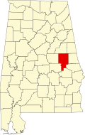
Church Hill is an unincorporated community in Tallapoosa County, Alabama, United States. Church Hill is the birthplace of Herschel W. Arant, a legal academic and jurist who served on the United States Court of Appeals for the Sixth Circuit from 1939 to 1941. [2] A post office was operated in Church Hill from 1888 to 1904. [3]
The Alabama River, in the U.S. state of Alabama, is formed by the Tallapoosa and Coosa rivers, which unite about 6 miles (10 km) north of Montgomery, near the town of Wetumpka.
Coosa County is located in the east central portion of the U.S. state of Alabama. As of the 2010 census the population was 11,539. Its county seat is Rockford. Its name derives from a town of the Creek tribe and the Coosa River, which forms one of the county borders.
Elmore County is a county located in the east central portion of the U.S. state of Alabama. As of the 2010 census, the population was 79,303. Its county seat is Wetumpka. Its name is in honor of General John A. Elmore.
Randolph County is a county on the central eastern border of the U.S. state of Alabama. As of the 2010 census, the population was 22,913. Its county seat is Wedowee. Its name is in honor of John Randolph, a member of the United States Senate from Virginia. Randolph County was a prohibition or dry county until 2012, when the citizens of Randolph County voted to repeal prohibition.
Tallapoosa County is located in the east central portion of the U.S. state of Alabama. As of the 2010 census, the population was 41,616. Its county seat is Dadeville. Its largest city is Alexander City.
Tallassee is a city on the Tallapoosa River, located in both Elmore and Tallapoosa counties in the U.S. state of Alabama. At the 2010 census the population was 4,819. It is home to a major hydroelectric power plant at Thurlow Dam operated by Alabama Power Company.
Wetumpka is a city in and the county seat of Elmore County, Alabama, United States. At the 2010 census the population was 6,528. In the early 21st century Elmore County became one of the fastest-growing counties in the state. The city is considered part of the Montgomery Metropolitan Area.
Camp Hill is a town in Tallapoosa County, Alabama, United States. It was incorporated in 1895. At the 2010 census the population was 1,014, down from 1,273 in 2000. Camp Hill is the home to Lyman Ward Military Academy.
Dadeville is a city in Tallapoosa County, Alabama, United States. At the 2010 census the population was 3,230, up from 3,212 in 2000. The city is the county seat of Tallapoosa County.
Tallapoosa is a city in Haralson County, Georgia, United States. The population was 3,170 at the 2010 census, up from 2,789 at the 2000 census.
U.S. Route 280 is a spur of U.S. Highway 80. It currently runs for 392 miles (631 km) from Blichton, Georgia at US 80 to Birmingham, Alabama at I-20/I-59. For much of its route, US 280 travels through rural areas and smaller cities in southern Georgia and east central Alabama. Once the highway approaches Birmingham, it is a major suburban route. Numerous shopping centers are located on US 280 throughout northern Shelby County and southern Jefferson County.
The Tallapoosa River runs 265 miles (426 km) from the southern end of the Appalachian Mountains in Georgia, United States, southward and westward into the Appalachian foothills in Alabama. It is formed by the confluence of McClendon Creek and Mud Creek in Paulding County, Georgia. Lake Martin at Alexander City, Alabama is a large and popular water recreation area formed by a dam on the river. The Tallapoosa joins the Coosa River about 10 miles (16 km) northeast of Montgomery near Wetumpka to form the Alabama River.
Lake Martin is located in Tallapoosa, Elmore and Coosa counties in Alabama. It is a 44,000-acre (178 km²) reservoir with over 750 miles (1,200 km) of wooded shoreline. Lake Martin is a reservoir, formed by the construction of Martin Dam on the Tallapoosa River. The Martin Dam powerhouse is used to generate hydroelectric power for the Alabama Power Company. Construction on Martin Dam began in 1923 and was completed in 1926, creating what was at that time the largest man-made body of water in the world. Originally known as Cherokee Bluffs for the geological formation upon which it was built, the dam was renamed in 1936 in honor of Thomas Martin, the then-president of Alabama Power Company. Alabama Power and Russell Lands own the majority of the shoreline.
Little Tallapoosa River is a 97-mile-long (156 km) river in Georgia and Alabama, in the United States. It rises in northern Carroll County, Georgia near the city of Villa Rica and flows southwest into Alabama, joining the Tallapoosa River in Randolph County near the head of R.L. Harris Reservoir.
State Route 49 (SR 49) is an 82.684-mile-long (133.067 km) state highway in the central and eastern parts of the U.S. state of Alabama. The southern terminus of the highway is at an interchange with Interstate 85 (I-85) at Franklin in Macon County. The northern terminus of the highway is at an intersection with SR 281 east of Cheaha State Park in southern Cleburne County.
State Route 50 (SR 50) is a 54.261-mile-long (87.325 km) state highway in the eastern part of the U.S. state of Alabama. The western terminus of the highway is at an intersection with SR 229 near Lake Martin in northeastern Elmore County. The eastern terminus of the highway is at an intersection with U.S. Route 29 (US 29) at Lanett, just west of the Georgia state line.
The Alabama Register of Landmarks and Heritage, commonly referred to as the Alabama Register, is an official listing of buildings, sites, structures, objects, and districts deemed worthy of preservation in the U.S. state of Alabama. These properties, which may be of national, state, and local significance, are designated by the Alabama Historical Commission. The designation is honorary and carries no direct restrictions or incentives. The register includes properties such as cemeteries, churches, moved properties, reconstructed properties, and properties at least 40 years old which may not normally qualify for listing in the National Register of Historic Places. There are approximately 1421 properties and districts listed on the Alabama Register. Of these, approximately 196 are also listed on the National Register of Historic Places and 5 are designated as National Historic Landmarks.
Tooktocaugee was an unincorporated community in Calhoun County, Alabama, United States. Tooktocaugee was formerly the site of a Creek Indian village.
Dudleyville, also known as Pittsborough, is an unincorporated community in Tallapoosa County, Alabama, United States. Dudleyville was named for Peter Dudley, who established the first trading post in the area. The town was incorporated on February 2, 1839. A post office was operated in Dudleyville from 1836 to 1907. Major Lemuel Montgomery, the first American soldier killed in the Battle of Horseshoe Bend, was formerly buried in the Dudleyville cemetery, before his grave was moved to Horseshoe Bend National Military Park. Abram Mordecai, a trader who installed the first cotton gin in Alabama, lived for a time in Dudleyville. It was here that Albert J. Pickett visited him in 1847 and gathered information from him to use in his History of Alabama. County Line Baptist Church, which is located east of Dudleyville, is listed on the National Register of Historic Places.
Cherokee Bluffs is an unincorporated community in Tallapoosa County, Alabama, United States. The bluffs were a landmark in Tallapoosa County, and they were chosen as the first site on the Tallapoosa River for the creation of a dam and reservoir.