Fosheeton, Alabama | |
|---|---|
 Fosheeton, Alabama  Fosheeton, Alabama | |
| Coordinates: 32°59′52″N85°49′37″W / 32.99778°N 85.82694°W | |
| Country | United States |
| State | Alabama |
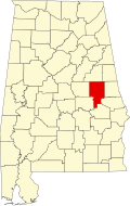
| County | Tallapoosa |
| Elevation | 741 ft (226 m) |
| Time zone | UTC−6 (Central (CST)) |
| • Summer (DST) | UTC−5 (CDT) |
| Area code | 256 |
| GNIS feature ID | 118530 [1] |
Fosheeton (also Fisheeton) is an unincorporated community in Tallapoosa County, Alabama, United States. [1]