Point Clear, Alabama

Last updated

Point Clear, Alabama
Post Office of Point Clear,Alabama.jpg
Point Clear, Alabama Post Office
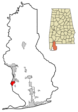
Baldwin County Alabama Incorporated and Unincorporated areas Point Clear Highlighted.svg
Location in Baldwin County and the state of Alabama
Coordinates: 30°29′48″N87°54′35″W / 30.49667°N 87.90972°W / 30.49667; -87.90972
Country United States
State Alabama
County Baldwin
Area
[1]
  Total4.63 sq mi (11.99 km2)
  Land4.59 sq mi (11.89 km2)
  Water0.04 sq mi (0.09 km2)
Elevation
10 ft (3 m)
Population
 (2020)
  Total2,076
  Density452.09/sq mi (174.54/km2)
Time zone UTC-6 (Central (CST))
  Summer (DST) UTC-5 (CDT)
ZIP code
36564
Area code 251
FIPS code 01-61488
GNIS feature ID0155211

Point Clear is an unincorporated census-designated place (CDP) in Baldwin County, Alabama, United States. As of the 2010 census, the population was 2,125. [2] It is part of the Daphne-Fairhope-Foley metropolitan area.

Contents

Geography

Point Clear is located at 30°29'48.505" North, 87°54'35.489" West (30.496807, -87.909858). [3]

According to the U.S. Census Bureau, the community has a total area of 5.5 square miles (14 km2), of which 5.5 square miles (14 km2) is land and 0.43% is water.

Demographics

Historical population
CensusPop.Note
1880 49
1980 1,812
1990 2,12517.3%
2000 1,876−11.7%
2010 2,12513.3%
2020 2,076−2.3%
U.S. Decennial Census [4]

2020 census

Point Clear racial composition [5]
RaceNum.Perc.
White (non-Hispanic)1,35665.32%
Black or African American (non-Hispanic)60729.24%
Asian 70.34%
Pacific Islander 10.05%
Other/Mixed 582.79%
Hispanic or Latino 472.26%

As of the 2020 United States census, there were 2,076 people, 793 households, and 639 families residing in the CDP.

2000 census

As of the census [6] of 2000, there were 1,876 people, 741 households, and 546 families residing in the community. The population density was 331.1 inhabitants per square mile (127.8/km2). There were 997 housing units at an average density of 176.0 per square mile (68.0/km2). The racial makeup of the community was 56.13% White, 42.70% Black or African American, 0.16% Native American, 0.16% Asian, 0.05% from other races, and 0.80% from two or more races. 0.59% of the population were Hispanic or Latino of any race.

There were 741 households, out of which 27.5% had children under the age of 18 living with them, 54.7% were married couples living together, 15.2% had a female householder with no husband present, and 26.2% were non-families. 23.8% of all households were made up of individuals, and 10.5% had someone living alone who was 65 years of age or older. The average household size was 2.53 and the average family size was 2.98.

In the community, the population was spread out, with 23.8% under the age of 18, 6.6% from 18 to 24, 24.1% from 25 to 44, 28.1% from 45 to 64, and 17.3% who were 65 years of age or older. The median age was 43 years. For every 100 females, there were 94.8 males. For every 100 females age 18 and over, there were 90.8 males.

The median income for a household in the community was $37,305, and the median income for a family was $45,729. Males had a median income of $39,844 versus $14,556 for females. The per capita income for the community was $26,271. About 16.1% of families and 18.1% of the population were below the poverty line, including 30.2% of those under age 18 and 16.7% of those age 65 or over.

Point Clear in World War II

Grand Hotel, Point Clear Alabama Grand Hotel, Point Clear Alabama.jpg
Grand Hotel, Point Clear Alabama

In 1944, Point Clear's Grand Hotel served as the base of operations for Operation Ivory Soap in World War II. In the Pacific Theater, the United States utilized the Leapfrogging (strategy) as a means of capturing islands held by the Japanese that were of strategic or tactical advantage. The commander of the U.S. Army Air Corps, Henry "Hap" Arnold, understood the American planes needed mobile air depots to support their efforts in the Pacific. Lieutenant Colonel Matthew Thompson, oversaw Operation Ivory Soap from a suite in the Grand Hotel. The nineteenth-century Alabama hotel housed soldiers and served as a maritime training facility training troops in skills including swimming, special calisthenics, marching, drill, navigation, ship identification, signaling, cargo handling, ship orientation, sail making and amphibious operations. The school produced 5,000 trained Army seamen who took part in operations in the Philippines, Iwo Jima, and Guam. The training these troops received thanks to Operation Ivory Soap allowed the soldiers to help save countless lives and aircraft. The name "Ivory Soap," according to Col. Thompson, was derived from the fact that, like the experimental Aircraft Repair Units the military wanted to deploy, Ivory soap floats. The Grand Hotel is still in operation on the eastern shore of Mobile Bay today. [7] [8]

Other

From as early as the 1800s, wealthy families from Mobile, New Orleans and across the United States chose to spend their summers in Point Clear. In the days of yellow fever outbreaks, Pt. Clear residents believed they were escaping to what was deemed as "good air" because of the daily breeze off Mobile Bay. Arrival to the area was traditionally by ferry boat and most people arrived in Pt. Clear at Zundel's Wharf. [9] Because of this, the front of the homes (sometimes referred to as cottages) face Mobile Bay and there is a boardwalk between the water and the homes leading to and from Zundel's Wharf. Remnants of the old pier at the Zundel property were still visible prior to Hurricane Katrina in 2005.

See also

Related Research Articles

<span class="mw-page-title-main">Spanish Fort, Alabama</span> City in Alabama, United States

Spanish Fort is a city in Baldwin County, Alabama, United States, located on the eastern shore of Mobile Bay. The 2020 census lists the population of the city as 10,049. It is a suburb of Mobile and is part of the Daphne-Fairhope-Foley metropolitan area.

Selmont-West Selmont is a census-designated place (CDP) in Dallas County, Alabama, United States. At the 2020 census, the population was 2,158.

<span class="mw-page-title-main">Theodore, Alabama</span> Census-designated place in Alabama, United States

Theodore is an unincorporated area and census-designated place (CDP) in Mobile County, Alabama, United States. The population was 6,270 at the 2020 census. It is a part of the Mobile metropolitan area. Prior to 1900 this area was known as "Clements", but it is now named for William Theodore Hieronymous, a sawmill operator and postmaster.

<span class="mw-page-title-main">Tillmans Corner, Alabama</span> Unincorporated community in Alabama, United States

Tillmans Corner, or Tillman’s Corner, is an unincorporated community and census-designated place (CDP) in Mobile County, Alabama, United States. At the 2020 census, the population was 17,731. It is part of the Mobile metropolitan area, and is the largest census-designated place in Alabama.

<span class="mw-page-title-main">Holt, Alabama</span> Census-designated place & Unincorporated community in Alabama, United States

Holt is an unincorporated community and census-designated place (CDP) in Tuscaloosa County, Alabama, United States. At the 2020 census, the population was 3,413. It is part of the Tuscaloosa, Alabama Metropolitan Statistical Area. Holt appeared on the 1930 census.

<span class="mw-page-title-main">Bellview, Florida</span> Census-designated place in Florida, United States

Bellview is a census-designated place (CDP) in Escambia County, Florida. It is considered to be a community within Pensacola. The population was 23,355 at the 2010 census. It is part of the Pensacola–Ferry Pass–Brent Metropolitan Statistical Area.

<span class="mw-page-title-main">Century, Florida</span> Town in Florida, United States

Century is a town in Escambia County, Florida, United States. Per the 2020 census, the population was 1,713. It is part of the Pensacola–Ferry Pass–Brent Metropolitan Statistical Area.

<span class="mw-page-title-main">McGregor, Florida</span> Census-designated place in Florida, United States

McGregor is a census-designated place (CDP) in Lee County, Florida, United States. The population was 7,976 at the 2020 census. It is part of the Cape Coral-Fort Myers, Florida Metropolitan Statistical Area.

<span class="mw-page-title-main">Bagdad, Florida</span> CDP in Florida, United States

Bagdad is a census-designated place (CDP) in Santa Rosa County, Florida, United States. The population was 1,490 at the 2000 census. It is part of the Pensacola–Ferry Pass–Brent Metropolitan Statistical Area.

<span class="mw-page-title-main">Clear Lake, Indiana</span> Town in Indiana, United States

Clear Lake is a town located in the northeast corner of Steuben County, Indiana, in Clear Lake Township. As such, is the northeasternmost community in the State of Indiana. The population was 339 at the 2010 census.

<span class="mw-page-title-main">Eldon, Iowa</span> City in Iowa, United States

Eldon is a city in Wapello County, Iowa, United States. The population was 783 at the time of the 2020 census. It is the site of the small Carpenter Gothic style house that has come to be known as the American Gothic House. Artist Grant Wood used this home for the background in his world-famous 1930 painting American Gothic.

<span class="mw-page-title-main">Pratt, Kansas</span> City in Pratt County, Kansas

Pratt is a city in and the county seat of Pratt County, Kansas, United States. As of the 2020 census, the population of the city was 6,603. It is home to Pratt Community College.

<span class="mw-page-title-main">Clearwater, Kansas</span> City in Sedgwick County, Kansas

Clearwater is a city in Sedgwick County, Kansas, United States. As of the 2020 census, the population of the city was 2,653.

<span class="mw-page-title-main">Addison, Michigan</span> Village in Michigan, United States

Addison is a village in Lenawee County of the U.S. state of Michigan. The population was 573 at the 2020 census. The village is located on the boundary between Rollin Township on the south and Woodstock Township on the north.

<span class="mw-page-title-main">Callaway, Minnesota</span> City in Minnesota, United States

Callaway is a city in Becker County, Minnesota, USA, approximately 11 miles from the county seat, Detroit Lakes, Minnesota. The population was 178 at the 2020 census. Callaway is often associated with a nearby town, Richwood, Minnesota.

<span class="mw-page-title-main">Backus, Minnesota</span> City in Minnesota, United States

Backus is a city in Cass County, Minnesota, United States. The population was 250 at the 2010 census. It is part of the Brainerd Micropolitan Statistical Area.

<span class="mw-page-title-main">Bell Township, Clearfield County, Pennsylvania</span> Township in Pennsylvania, United States

Bell Township is a township in Clearfield County, Pennsylvania, United States. The population was 686 at the 2020 census.

<span class="mw-page-title-main">Black Creek Township, Pennsylvania</span> Township in Pennsylvania, United States

Black Creek Township is a township in Luzerne County, Pennsylvania, United States. The population was 1,904 as of the 2020 census.

<span class="mw-page-title-main">Union Grove, Texas</span> City in Texas, United States

Union Grove is a city in Upshur County, Texas, United States. The population was 357 at the 2010 census.

<span class="mw-page-title-main">Soap Lake, Washington</span> City in Washington, United States

Soap Lake is a city in Grant County, Washington, on the shores of Soap Lake. The population was 1,691 at the 2020 census.

References

  1. "2020 U.S. Gazetteer Files". United States Census Bureau. Retrieved October 29, 2021.
  2. "U.S. Census website". United States Census Bureau . Retrieved May 14, 2011.
  3. "US Gazetteer files: 2010, 2000, and 1990". United States Census Bureau. February 12, 2011. Retrieved April 23, 2011.
  4. "U.S. Decennial Census". Census.gov. Retrieved June 6, 2013.
  5. "Explore Census Data". Data.census.gov. Retrieved December 17, 2021.
  6. "U.S. Census website". United States Census Bureau . Retrieved January 31, 2008.
  7. "Congressional Record (Bound Edition), Volume 146 (2000), Part 15 - OPERATION IVORY SOAP". Gpo.gov.
  8. "Operation Ivory Soap". Mobilebaymag.com. December 2, 2016.
  9. "Archived copy". Archived from the original on May 17, 2017. Retrieved February 15, 2022.{{cite web}}: CS1 maint: archived copy as title (link)

30°29′49″N87°54′35″W / 30.496807°N 87.909858°W / 30.496807; -87.909858