
Baldwin County is a county located in the southwestern part of the U.S. state of Alabama, on the Gulf coast. It is one of only two counties in Alabama that border the Gulf of Mexico, along with Mobile County. As of the 2020 census, the population was 231,767, making it the fourth-most populous county in Alabama. The county seat is Bay Minette. The county is named after the founder of the University of Georgia, Senator Abraham Baldwin.

Gulf Shores is a resort city in Baldwin County, Alabama, United States. As of the 2020 Census, the population was 15,014.

Orange Beach is a resort city in Baldwin County, Alabama, United States. The population was 8,095 at the 2020 census. and according to 2023 census estimates, the city is estimated to have a population of 8,534.

The Florida panhandle is the northwestern part of the U.S. state of Florida. It is a salient roughly 200 miles (320 km) long, bordered by Alabama on the north and the west, Georgia on the north, and the Gulf of Mexico to the south. Its eastern boundary is arbitrarily defined. It is defined by its southern culture and rural geography relative to the rest of Florida, as well as closer cultural links to French-influenced Louisiana, Mississippi, and Alabama. Its major communities include Pensacola, Navarre, Destin, Panama City Beach, and Tallahassee.
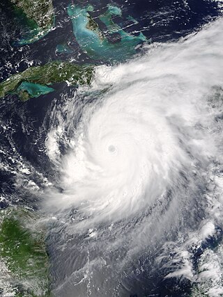
Hurricane Ivan was a large, long-lived, and devastating tropical cyclone that caused widespread damage in the Caribbean and United States. The ninth named storm, the sixth hurricane, and the fourth major hurricane of the active 2004 Atlantic hurricane season, Ivan formed in early September and reached Category 5 strength on the Saffir–Simpson Hurricane Scale (SSHS). Ivan caused catastrophic damage in Grenada as a strong Category 3 storm, heavy damage in Jamaica as a strong Category 4 storm, and then severe damage in Grand Cayman, Cayman Islands, and the western tip of Cuba as a Category 5 hurricane. After peaking in strength, the hurricane moved north-northwest across the Gulf of Mexico to strike Pensacola/Milton, Florida and Alabama as a strong Category 3 storm, causing significant damage. Ivan dropped heavy rain on the Southeastern United States as it progressed northeastward and eastward through the Eastern United States, becoming an extratropical cyclone on September 18. The remnant low of the storm moved into the western subtropical Atlantic and regenerated into a tropical cyclone on September 22, which then moved across Florida and the Gulf of Mexico, and then into Louisiana and Texas, causing minimal damage. Ivan degenerated into a remnant low on September 24, before dissipating on the next day.

Gulf Islands National Seashore is an American National seashore that offers recreation opportunities and preserves natural and historic resources along the Gulf of Mexico barrier islands of Florida and Mississippi. In 2023, it was the fifth-most visited unit of the National Park Service.

Perdido Key is an unincorporated community located in Escambia County, Florida, United States, between the cities of Pensacola, Florida and Orange Beach, Alabama. The community is located on and named for Perdido Key, a barrier island in northwest Florida and southeast Alabama. "Perdido" means "lost" in the Spanish and Portuguese languages. The Florida district of the Gulf Islands National Seashore includes the east end of the island, as well as other Florida islands. No more than a few hundred yards wide in most places, Perdido Key stretches some 16 miles (26 km) from near Pensacola to Perdido Pass Bridge near Orange Beach.

Lillian is an unincorporated community and census-designated place in eastern Baldwin County, Alabama, United States. Lillian is located on U.S. Route 98 on the western shore of Perdido Bay, 9.5 miles (15.3 km) east of Elberta. Its eastern edge lies on the Alabama/Florida state line.
Tropical Storm Arlene was an unusually large and early-forming tropical storm, being the first of twenty-eight different storms during the 2005 Atlantic hurricane season, which would become the second most active season on record. Tropical Storm Arlene formed near Honduras on June 8 and moved northwards. It crossed western Cuba on June 10 and strengthened to just under hurricane strength before making its final landfall on the Florida Panhandle the next day. The storm weakened as it continued to move north over the United States, becoming extratropical on June 13. Arlene was responsible for two deaths and minor damage.

The Mobile Metropolitan Area comprises Mobile in the southwest corner of Alabama in the United States. As of the 2020 census the metropolitan area had a population of 430,197. The Mobile metropolitan area is the third-largest metropolitan area in the state of Alabama, after Birmingham and Huntsville. Washington County was part of the Mobile metropolitan area but was removed when the OMB released its statistical definitions effective July 2023.

Bon Secour is an unincorporated community and census-designated place in Baldwin County, Alabama, United States. It lies along the eastern coastline of Bon Secour Bay. Bon Secour is over 35 miles (56 km) due east of the Alabama–Mississippi state line, near Gulf Shores, and over 45 miles (72 km) west of Pensacola, Florida. The name "Bon Secour" derives from the French phrase meaning "safe harbor" due to the secluded location on the inside coast of the Fort Morgan peninsula of southern Alabama.

Interstate 10 (I-10) is a part of the Interstate Highway System that runs from Santa Monica, California, to Jacksonville, Florida. In Alabama, the Interstate Highway runs 66.269 miles (106.650 km) from the Mississippi state line near Grand Bay east to the Florida state line at the Perdido River. I-10 is the primary east–west highway of the Gulf Coast region of Alabama. The highway connects Mobile, the largest city in South Alabama, with Pascagoula, Mississippi, to the west and Pensacola, Florida, to the east. Within the state, the highway connects Mobile and Mobile County with the Baldwin County communities of Daphne and Fairhope. I-10 connects Mobile and Baldwin County by crossing the northern end of Mobile Bay and the southern end of the Mobile-Tensaw River Delta via the George Wallace Tunnel in Mobile and the Jubilee Parkway viaduct system between Mobile and Daphne.

Perdido Pass, separating Alabama Point from Florida Point, is the mouth of the Perdido River. Perdido Pass forms a water passage that connects Perdido Bay with the Gulf of Mexico to the south, in the U.S. state of Alabama, 2 miles (3 km) west of the Alabama/Florida state line. A bridge spans Perdido Pass, connecting Alabama Point with Florida Point in Alabama. At the entrance into the Gulf, the 2 rock barriers, extending from the white beaches, are the west jetty & east jetty. The surrounding area is heavily developed, with high-rise condominiums. However, there are nearby beach-front parks, with Gulf State Park on the eastern side of Perdido Pass.
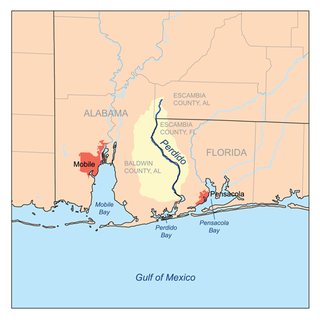
Perdido Bay is a bay at the mouth of and draining the Perdido River, a designated Outstanding Florida Waters river, in Baldwin County, Alabama and Escambia County, Florida, United States. It is essentially a coastal lagoon enclosed by barrier islands, with an inlet, Perdido Pass.
Perdido is a Spanish and Portuguese word for ‘lost’. It may refer to:

Perdido Beach is a town located on the northern shore of Perdido Bay, between the mouths of Soldier Creek and Palmetto Creek in Baldwin County, Alabama, United States. In an April 2009 plebiscite, over 60% of local voters supported incorporation as a town. On June 10, 2009, Baldwin County Probate Judge Adrian Johns issued an order which incorporated the area as a town. The first municipal elections, in which the mayor and town council will be elected, were scheduled for the fall of 2009. As of the 2010 census, the town had a population of 581.
Pensacola Pass is an inlet between Santa Rosa Island and Perdido Key at the western end of the Florida Panhandle. It connects the Gulf of Mexico to Pensacola Bay. The mainland around Pensacola Bay is heavily developed, with high-rise condominiums. Santa Rosa Island and the eastern part of Perdido Key adjacent to Pensacola Pass are units of the Gulf Islands National Seashore, and remain largely undeveloped.

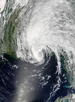
Hurricane Sally was a destructive and slow-moving tropical cyclone that was the first hurricane to make landfall in the U.S. state of Alabama since Ivan in 2004, coincidentally on the same date in the same place. The eighteenth named storm and seventh hurricane of the extremely active 2020 Atlantic hurricane season, Sally developed from an area of disturbed weather which was first monitored over the Bahamas on September 10. The system grew a broad area of low-pressure on September 11, and was designated as a tropical depression late that day. Early the next day, the depression made landfall at Key Biscayne and subsequently strengthened into Tropical Storm Sally that afternoon. Moderate northwesterly shear prevented significant intensification for the first two days, but convection continued to grow towards the center and Sally slowly intensified. On September 14, a center reformation into the center of the convection occurred, and data from a hurricane hunter reconnaissance aircraft showed that Sally had rapidly intensified into a strong Category 1 hurricane. However, an increase in wind shear and upwelling of colder waters halted the intensification and Sally weakened slightly on September 15 before turning slowly northeastward. Despite this increase in wind shear, it unexpectedly re-intensified, reaching Category 2 status early on September 16 before making landfall at peak intensity at 09:45 UTC on September 16, near Gulf Shores, Alabama, with maximum sustained winds of 110 mph (180 km/h) and a minimum central pressure of 965 millibars (28.5 inHg). The storm rapidly weakened after landfall before transitioning into an extratropical low at 12:00 UTC the next day. Sally's remnants lasted for another day as they moved off the coast of the Southeastern United States before being absorbed into another extratropical storm on September 18.
Perdido Key is a 24-kilometre-long (15 mi) barrier island on the north coast of the Gulf of Mexico. The island extends from Pensacola Pass on the east to Perdido Pass on the west. Most of the island is in Florida, with the western end of the island in Alabama. Santa Rosa Island is to the east of the island, and Alabama Point is to the west. Perdido Key was attached to the mainland until the 1940s when a canal separated it from the mainland. The eastern part of the island forms part of the Gulf Islands National Seashore, which includes the Perdido Key Historic District, the site of three shore batteries that once defended Pensacola Bay. The rest of the island, with the exception of the Perdido Key State Park, has been developed as a resort and residential community. As a barrier island, Perdidio Key is subject to changes due to wave action and longshore currents, particularly from hurricanes. The endangered Perdido Key beach mouse is endemic to the island.

