Maplesville, Alabama

Last updated

Maplesville, Alabama
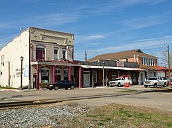
Maplesville Alabama Feb 2012 03.jpg
Chilton County Alabama Incorporated and Unincorporated areas Maplesville Highlighted 0146504.svg
Location of Maplesville in Chilton County, Alabama.
Coordinates: 32°46′55″N86°52′32″W / 32.78194°N 86.87556°W / 32.78194; -86.87556
Country United States
State Alabama
County Chilton
Government
  MayorW.C. Hayes, Jr.
Area
[1]
  Total3.48 sq mi (9.00 km2)
  Land3.43 sq mi (8.89 km2)
  Water0.04 sq mi (0.11 km2)
Elevation
351 ft (107 m)
Population
 (2020)
  Total637
  Density185.50/sq mi (71.63/km2)
Time zone UTC-6 (Central (CST))
  Summer (DST) UTC-5 (CDT)
ZIP code
36750
Area code 334
FIPS code 01-46504
GNIS feature ID0160032
Website www.townofmaplesville.com

Maplesville is a town in Chilton County, Alabama, United States. At the 2020 census, the population was 637. It is located approximately halfway between Tuscaloosa and Montgomery on U.S. Route 82.

Contents

The mayor of Maplesville is W. C. Hayes, Jr.

History

The Walker-Klinner Farm in Maplesville Walker-Klinner Farm Feb 2012 01.jpg
The Walker-Klinner Farm in Maplesville

The town of Maplesville first began to grow in a location 3 miles (5 km) east of its present location, near Mulberry Creek. European settlers migrated to the area from Georgia and the Carolinas following the Battle of Horseshoe Bend in 1814, after the Native Americans who had been living there were defeated. The town was named after Stephen W. Maples, a merchant and the town's first postmaster.

The town was located at the crossroads of two important trading routes: the Elyton Road from Selma to Birmingham, and the Fort Jackson Road from Tuscaloosa to Montgomery. By 1850, the original town of Maplesville had a population of 809. The town had two horse-racing tracks, which brought visitors to the town, and had several inns and taverns to accommodate the stagecoach traffic.

The original town site began to decline in the early 1850s, after two railway lines were completed 3 miles west of the town. The Alabama & Tennessee River Railway was constructed through in 1853. That same year, a depot was constructed at that location. Residents and businesspeople from the original Maplesville began moving closer to the railroad, and when the Maplesville Post Office was relocated to the railroad town in 1856, the new town was renamed Maplesville. The original town site gradually became deserted, and all that remains today is the Old Maplesville Cemetery along Highway 191. The Old Maplesville Cemetery contains many of the town's original inhabitants. This cemetery is also home to the oldest grave in Chilton County, dating back to 1833. [2] However, the cemetery is just a fraction of its former size. Today, roughly 50 of the original tombstones remain. During the construction of Highway 191, several of the graves were destroyed during the process. [3]

Because of Maplesville's abundant rail access, it became a shipping point for cotton and other goods from the surrounding area. In 1865, the train depot was destroyed in a raid by Union general James H. Wilson, as Wilson's Raiders marched on to Selma. It was replaced soon after the Civil War, but was destroyed by fire in 1911.

Maplesville continued to prosper after the Mobile and Ohio Railroad ran a line through the town in 1897, and many of the historic buildings in the town today were built during that period. In 1901, a lumber mill opened near the town, and the town's population grew as people moved to Maplesville to work at the mill. Maplesville incorporated in 1914, but the incorporation soon lapsed because the town failed to hold elections after the initial round. It reincorporated in 1947, and by 1951 had established a telephone system, garbage pick-up, and water system.

A new town hall was completed in 1975. [4] [5]

There are four historic sites currently recognized in Maplesville. The Walker-Klinner Farm is listed on the National Register of Historic Places, and the following three locations are listed on the Alabama Register of Landmarks and Heritage:

Geography

Maplesville is located in southwestern Chilton County at 32°46'54.800" North, 86°52'31.861" West (32.781889, -86.875517). [6] It is located along U.S. Route 82, which runs northwest to southeast on the south side of town. Tuscaloosa is 55 mi (89 km) to the northwest, and Montgomery is 49 mi (79 km) to the southeast, both via US-82. Alabama State Route 22 runs west to east through the center of town, leading east 15 mi (24 km) to Clanton, the Chilton County seat, and southwest 29 mi (47 km) to Selma.

According to the U.S. Census Bureau, the town has a total area of 3.3 square miles (8.6 km2), of which 3.3 square miles (8.5 km2) is land and 0.04 square miles (0.1 km2), or 1.22%, is water. [7]

Demographics

Historical population
CensusPop.Note
1920 376
1930 45621.3%
1950 806
1960 679−15.8%
1970 596−12.2%
1980 75426.5%
1990 725−3.8%
2000 672−7.3%
2010 7085.4%
2020 637−10.0%
U.S. Decennial Census [8]
2013 Estimate [9]

2020 census

Maplesville racial composition [10]
RaceNum.Perc.
White (non-Hispanic)43968.92%
Black or African American (non-Hispanic)15424.18%
Native American 40.63%
Other/Mixed 284.4%
Hispanic or Latino 121.88%

As of the 2020 United States census, there were 637 people, 246 households, and 163 families residing in the town.

2007

As of the census [11] of 2007, there were 2500 people, 268 households, and 183 families residing in the town. The population density was 205.8 inhabitants per square mile (79.5/km2). There were 313 housing units at an average density of 95.9 per square mile (37.0/km2). The racial makeup of the town was 69.94% White, 29.61% Black or African American and 0.45% Native American. 0.89% of the population were Hispanic or Latino of any race.

There were 268 households, out of which 32.8% had children under the age of 18 living with them, 52.2% were married couples living together, 11.9% had a female householder with no husband present, and 31.7% were non-families. 30.2% of all households were made up of individuals, and 12.7% had someone living alone who was 65 years of age or older. The average household size was 2.51 and the average family size was 3.13.

In the town, the population was spread out, with 25.3% under the age of 18, 10.1% from 18 to 24, 26.9% from 25 to 44, 23.5% from 45 to 64, and 14.1% who were 65 years of age or older. The median age was 37 years. For every 100 females, there were 95.9 males. For every 100 females age 18 and over, there were 88.0 males.

The median income for a household in the town was $27,500, and the median income for a family was $36,250. Males had a median income of $31,042 versus $22,361 for females. The per capita income for the town was $12,777. About 12.6% of families and 20.1% of the population were below the poverty line, including 26.7% of those under age 18 and 16.0% of those age 65 or over.
Local attractions

Attractions

Places of worship

Historic cemeteries

Historic buildings

Notable people

Related Research Articles

<span class="mw-page-title-main">Chilton County, Alabama</span> County in Alabama, United States

Chilton County is a county located in the central portion of the U.S. state of Alabama. As of the 2020 census, the population was 45,014. The county seat is Clanton. Its name is in honor of William Parish Chilton, Sr. (1810–1871), a lawyer who became Chief Justice of the Alabama Supreme Court and later represented Montgomery County in the Congress of the Confederate States of America.

<span class="mw-page-title-main">Autaugaville, Alabama</span> Town in Alabama, United States

Autaugaville is a town in Autauga County, Alabama, United States. At the 2020 census, the population was 795. It is part of the Montgomery Metropolitan Statistical Area.

<span class="mw-page-title-main">Billingsley, Alabama</span> Village in Alabama, United States

Billingsley is a village in Autauga County, Alabama, United States. At the 2020 census, the population was 125. It is part of the Montgomery Metropolitan Statistical Area.

<span class="mw-page-title-main">Calera, Alabama</span> City in Alabama, United States

Calera is a city in Shelby and Chilton counties in the U.S. state of Alabama. It is the location of the Shelby County Airport.

<span class="mw-page-title-main">Clanton, Alabama</span> City in and county seat of Chilton County, Alabama

Clanton is a city in Chilton County, Alabama, United States. It is part of the Birmingham–Hoover–Cullman Combined Statistical Area. At the 2020 census, the population was 14,545. The city is the county seat of Chilton County. Clanton is near the site of the geographic center of the U.S. state of Alabama.

<span class="mw-page-title-main">Jemison, Alabama</span> City in Alabama, United States

Jemison is a city in Chilton County, Alabama, United States. At the 2020 census, the population was 2,642. The center of population of Alabama is located outside of Jemison, an area known as Jemison Division.

<span class="mw-page-title-main">Thorsby, Alabama</span> Town in Alabama, United States

Thorsby is a town in Chilton County, Alabama, United States. As of the 2020 census, the population of the town was 2,064.

<span class="mw-page-title-main">Kinston, Alabama</span> Town in Alabama, United States

Kinston is a town in Coffee County, Alabama, United States. At the 2020 census, the population was 580. It is part of the Enterprise Micropolitan Statistical Area.

<span class="mw-page-title-main">Lockhart, Alabama</span> Town in Alabama, United States

Lockhart is a town in Covington County, Alabama, United States. At the 2020 census, the population was 445.

<span class="mw-page-title-main">Deatsville, Alabama</span> Town in Alabama, United States

Deatsville is a town in Elmore County, Alabama, United States. Although Deatsville initially incorporated in 1903, it lapsed at some point after the 1910 U.S. Census and did not appear again as incorporated until 2000. As of the 2020 census, the population was 1,679.

<span class="mw-page-title-main">Moundville, Alabama</span> Town in Alabama, United States

Moundville is a town in Hale and Tuscaloosa counties in the U.S. state of Alabama. It was incorporated on December 22, 1908. From its incorporation until the 1970 census, it was wholly within Hale County. At the 2010 census the population was 2,427, up from 1,809 at the 2000 census. It is part of the Tuscaloosa Metropolitan Statistical Area. Within the town is Moundville Archaeological Site, the location of a prehistoric Mississippian culture political and ceremonial center.

<span class="mw-page-title-main">Stevenson, Alabama</span> City in Alabama, United States

Stevenson is a city in Jackson County, Alabama, United States, and is included in the Chattanooga-Cleveland-Dalton, TN-GA-AL Combined Statistical Area. Sources listed either 1866 or 1867 as the year of incorporation, but that seems to conflict with the dates given for the town being granted a charter. It did not first appear on the U.S. Census until 1880, where it was the second largest town in Jackson County behind Scottsboro. Since 1900, it has been the third largest town behind either Scottsboro and Bridgeport or vice versa. At the 2020 census, the population of the city was 1,955, down from 2,046 in 2010.

<span class="mw-page-title-main">Woodville, Alabama</span> Town in Alabama, United States

Woodville is a town in Jackson County, Alabama, United States. It was officially established by an act of the Alabama State Legislature on December 13, 1819, one day before Alabama became a state. It was later incorporated on May 12, 1890, but lost its charter in 1897. It reincorporated in 1912. As of the 2010 census, the population of the town is 746, down from 761 in 2000.

<span class="mw-page-title-main">Mulga, Alabama</span> Town in Alabama, United States

Mulga is a town in western Jefferson County, Alabama, United States. It is north from the Birmingham suburb of Pleasant Grove. It includes the community of Bayview. Mulga was a company town operated by Birmingham Coal and Iron Company around the Mulga Mine and Mulga was also the name of an independent community in the area. The company town was incorporated in 1947.

<span class="mw-page-title-main">Millport, Alabama</span> Town in Alabama, United States

Millport is a town in Lamar County, Alabama, United States. It incorporated in 1887. At the 2010 census the population was 1,049, down from 1,160 in 2000. After its incorporation from 1890 to 1900, it was the largest town in Lamar County, losing the distinction to Sulligent. Since 1940, it has been the 3rd largest town.

<span class="mw-page-title-main">Elkmont, Alabama</span> Town in Alabama, United States

Elkmont is a town in Limestone County, Alabama, United States, and is included in the Huntsville-Decatur Combined Statistical Area. As of the 2010 census, the population of the town was 434, down from its record high of 470 in 2000.

<span class="mw-page-title-main">Lowndesboro, Alabama</span> Town in Alabama, United States

Lowndesboro is a town in Lowndes County, Alabama, United States. At the 2010 census the population was 115, down from 140 in 2000. It is part of the Montgomery Metropolitan Statistical Area. Although initially incorporated in 1856 by an act of the state legislature, it lapsed and was not reincorporated until 1962.

<span class="mw-page-title-main">Linden, Alabama</span> City in Alabama, United States

Linden is a city in and the county seat of Marengo County, Alabama, United States. The population was 1,930 at the 2020 census, down from 2,123 at the 2010 census.

<span class="mw-page-title-main">Wilsonville, Alabama</span> Town in Alabama, United States

Wilsonville is a town in southeastern Shelby County, Alabama, United States, located northeast of Columbiana. At the 2020 census, the population was 1,857. Wilsonville is named after the earliest settler in the area, Elisha Wilson.

<span class="mw-page-title-main">Brookwood, Alabama</span> City in Alabama, United States

Brookwood is a city in Tuscaloosa County, Alabama, United States. It incorporated in September 1977. As of the 2020 census, the population of the town is 2,504.

References

  1. "2020 U.S. Gazetteer Files". United States Census Bureau. Retrieved October 29, 2021.
  2. "The Official Website of Maplesville, Alabama-Cemeteries." Accessed January 29, 2020. www.townofmaplesville.com/cemeteries.html.
  3. Maplesville: The Town and The People, (1820-1989). Montevallo, Ala.:Times Print Co., 1989.
  4. "History of Maplesville, Alabama". Town of Maplesville, Alabama. Retrieved March 2, 2013.
  5. Kaetz, James P. (February 7, 2013). "Maplesville". Encyclopedia of Alabama.
  6. "US Gazetteer files: 2010, 2000, and 1990". United States Census Bureau. February 12, 2011. Retrieved April 23, 2011.
  7. "Geographic Identifiers: 2010 Demographic Profile Data (G001): Maplesville city, Alabama". U.S. Census Bureau, American Factfinder. Archived from the original on February 12, 2020. Retrieved June 4, 2014.
  8. "U.S. Decennial Census". Census.gov. Retrieved June 6, 2013.
  9. "Annual Estimates of the Resident Population: April 1, 2010 to July 1, 2013" . Retrieved June 3, 2014.
  10. "Explore Census Data". data.census.gov. Retrieved December 18, 2021.
  11. "U.S. Census website". United States Census Bureau . Retrieved January 31, 2008.

32°46′55″N86°52′32″W / 32.781889°N 86.875517°W / 32.781889; -86.875517