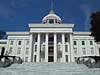
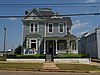
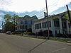
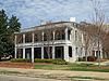
[3] Name on the Register Image Date listed [4] Location City or town Description 1 Alabama State Capitol Alabama State Capitol October 15, 1966 (# 66000152 Goat Hill, eastern end of Dexter Ave. 32°22′41″N 86°18′02″W / 32.378°N 86.3005°W / 32.378; -86.3005 (Alabama State Capitol ) Montgomery 2 Alabama State University Historic District Alabama State University Historic District October 8, 1998 (# 98001228 915 S. Jackson St. 32°21′51″N 86°17′51″W / 32.3642°N 86.2975°W / 32.3642; -86.2975 (Alabama State University Historic District ) Montgomery 3 Bell Building Bell Building December 15, 1981 (# 81000132 207 Montgomery St. 32°22′36″N 86°18′39″W / 32.3766°N 86.3107°W / 32.3766; -86.3107 (Bell Building ) Montgomery 4 Brame House Upload image September 17, 1980 (# 80000728 402-404 S. Hull St. 32°22′24″N 86°18′14″W / 32.3734°N 86.3039°W / 32.3734; -86.3039 (Brame House ) Montgomery Building no longer at this location 5 Bricklayers Hall Upload image July 23, 2020 (# 100005355 530 South Union St. 32°22′17″N 86°17′59″W / 32.3713°N 86.2996°W / 32.3713; -86.2996 (Bricklayers Hall ) Montgomery 6 Patrick Henry Brittan House Patrick Henry Brittan House December 13, 1979 (# 79000393 507 Columbus St. 32°22′57″N 86°18′08″W / 32.38241°N 86.30227°W / 32.38241; -86.30227 (Patrick Henry Brittan House ) Montgomery 7 Building 800-Austin Hall Building 800-Austin Hall March 2, 1988 (# 87002178 2nd St. at Maxwell Air Force Base 32°22′42″N 86°21′03″W / 32.3783°N 86.3508°W / 32.3783; -86.3508 (Building 800-Austin Hall ) Montgomery 8 Building 836-Community College of the Air Force Building Building 836-Community College of the Air Force Building March 2, 1988 (# 87002182 Maxwell Boulevard at Maxwell Air Force Base 32°22′49″N 86°21′07″W / 32.3804°N 86.3519°W / 32.3804; -86.3519 (Building 836-Community College of the Air Force Building ) Montgomery 9 Cassimus House Cassimus House August 13, 1976 (# 76000349 110 N. Jackson St. 32°22′43″N 86°17′47″W / 32.3786°N 86.2964°W / 32.3786; -86.2964 (Cassimus House ) Montgomery 10 Centennial Hill Historic District Upload image June 25, 2024 (# 100010461 Roughly bound by Highland and Adams Avenue to the north, Hall Street to the east, I-85 to the south, and South Bainbridge Street to the west 32°22′20″N 86°17′47″W / 32.3721°N 86.2964°W / 32.3721; -86.2964 (Centennial Hill Historic District ) Montgomery 11 City of St. Jude Historic District City of St. Jude Historic District June 18, 1990 (# 90000916 2048 W. Fairview Ave. 32°21′10″N 86°19′37″W / 32.3528°N 86.3269°W / 32.3528; -86.3269 (City of St. Jude Historic District ) Montgomery 12 Cleveland Court Apartments 620–638 Cleveland Court Apartments 620–638 October 29, 2001 (# 01001167 620-638 Cleveland Ct. 32°21′49″N 86°19′04″W / 32.3635°N 86.3178°W / 32.3635; -86.3178 (Cleveland Court Apartments 620–638 ) Montgomery 13 Cloverdale Historic District Cloverdale Historic District September 12, 1985 (# 85002161 Roughly bounded by Norman Bridge and Cloverdale Rd., Fairview and Felder Aves. and Boultier St. 32°21′18″N 86°17′42″W / 32.355°N 86.295°W / 32.355; -86.295 (Cloverdale Historic District ) Montgomery 14 Cottage Hill Historic District Cottage Hill Historic District November 7, 1976 (# 76000350 Roughly bounded by Goldthwaite, Bell, Holt, and Clayton Sts. 32°22′29″N 86°19′05″W / 32.3747°N 86.3181°W / 32.3747; -86.3181 (Cottage Hill Historic District ) Montgomery 15 Court Square Historic District Court Square Historic District March 1, 1982 (# 82002062 21-35 Court St., 1-2 Dexter Ave., 18-24 N. Court St., and Court Sq.; also roughly Dexter Ave. and Perry, Court, and Monroe Sts. 32°22′38″N 86°18′32″W / 32.3772°N 86.3089°W / 32.3772; -86.3089 (Court Square Historic District ) Montgomery Second set of boundaries represents a boundary increase, the Court Square-Dexter Avenue Historic District Boundary Increase, listed on August 30, 1984 16 Jefferson Davis Hotel Jefferson Davis Hotel March 13, 1979 (# 75000324 Catoma and Montgomery Sts. 32°22′33″N 86°18′45″W / 32.3758°N 86.3125°W / 32.3758; -86.3125 (Jefferson Davis Hotel ) Montgomery 17 Dexter Avenue Baptist Church Dexter Avenue Baptist Church July 1, 1974 (# 74000431 454 Dexter Ave. 32°22′38″N 86°18′10″W / 32.3773°N 86.3027°W / 32.3773; -86.3027 (Dexter Avenue Baptist Church ) Montgomery 18 Dowe Historic District Dowe Historic District December 29, 1988 (# 88003076 320 and 334 Washington Ave. and 114-116 S. Hull St. 32°22′34″N 86°18′14″W / 32.3761°N 86.3039°W / 32.3761; -86.3039 (Dowe Historic District ) Montgomery 19 Edgewood Edgewood April 24, 1973 (# 73000367 3175 Thomas Ave. 32°20′48″N 86°17′12″W / 32.3468°N 86.2866°W / 32.3468; -86.2866 (Edgewood ) Montgomery 20 First Baptist Church First Baptist Church June 25, 2024 (# 100010460 347 N. Ripley Street 32°22′55″N 86°17′55″W / 32.3819°N 86.2986°W / 32.3819; -86.2986 (First Baptist Church ) Montgomery 21 First White House of the Confederacy First White House of the Confederacy June 25, 1974 (# 74000432 644 Washington Ave. 32°22′34″N 86°18′00″W / 32.37618°N 86.2999°W / 32.37618; -86.2999 (First White House of the Confederacy ) Montgomery 22 Garden District Garden District September 13, 1984 (# 84000698 Roughly bounded by Norman Bridge Rd., Court St., and Jeff Davis and Fairview Aves. 32°21′29″N 86°18′19″W / 32.3581°N 86.3053°W / 32.3581; -86.3053 (Garden District ) Montgomery 23 Gay House Gay House March 15, 1975 (# 75000325 230 Noble Ave. 32°21′46″N 86°18′17″W / 32.3629°N 86.3048°W / 32.3629; -86.3048 (Gay House ) Montgomery Destroyed by fire in 2007. 24 Gerald-Dowdell House Gerald-Dowdell House April 28, 1980 (# 80000729 405 S. Hull St. 32°22′25″N 86°18′12″W / 32.37349°N 86.3033°W / 32.37349; -86.3033 (Gerald-Dowdell House ) Montgomery 25 Governor's Mansion Governor's Mansion July 3, 1972 (# 72000172 1142 S. Perry St. 32°21′43″N 86°18′27″W / 32.36192°N 86.30739°W / 32.36192; -86.30739 (Governor's Mansion ) Montgomery 26 Grace Episcopal Church Grace Episcopal Church February 19, 1982 (# 82002067 906 Pike Rd. 32°21′18″N 86°05′51″W / 32.3551°N 86.09737°W / 32.3551; -86.09737 (Grace Episcopal Church ) Mount Meigs 27 Grove Court Apartments Grove Court Apartments December 11, 2013 (# 13000894 559 S. Court St. 32°22′14″N 86°18′30″W / 32.370474°N 86.308327°W / 32.370474; -86.308327 (Grove Court Apartments ) Montgomery 28 Harrington Archaeological Site Upload image January 25, 1979 (# 79000394 Address Restricted Montgomery 29 Huntingdon College Campus Historic District Huntingdon College Campus Historic District February 24, 2000 (# 00000138 1500 E. Fairview Ave. 32°20′59″N 86°17′06″W / 32.349722°N 86.285°W / 32.349722; -86.285 (Huntingdon College Campus Historic District ) Montgomery 30 Jefferson Franklin Jackson House Jefferson Franklin Jackson House May 17, 1984 (# 84000711 409 S. Union St. 32°22′25″N 86°17′56″W / 32.37348°N 86.29894°W / 32.37348; -86.29894 (Jefferson Franklin Jackson House ) Montgomery 31 Gov. Thomas G. Jones House Gov. Thomas G. Jones House December 8, 1978 (# 78000506 323 Adams Ave. 32°22′32″N 86°18′14″W / 32.37545°N 86.30384°W / 32.37545; -86.30384 (Gov. Thomas G. Jones House ) Montgomery 32 Lower Commerce Street Historic District Lower Commerce Street Historic District March 29, 1979 (# 79000395 Roughly bounded by railroad tracks, Commerce, N. Court, and Bibb Sts.; also roughly bounded by railroad tracks, N. Court, Commerce, Coosa, and Tallapoosa Sts; also roughly bounded by the former Central of Georgia railroad tracks, N. Lawrence St., Madison Ave., and Commerce St. 32°22′49″N 86°18′38″W / 32.380278°N 86.310556°W / 32.380278; -86.310556 (Lower Commerce Street Historic District ) Montgomery Second and third sets of boundaries represent boundary increases of February 25, 1982 and January 15, 1987 33 Maxwell Air Force Base Senior Officers' Quarters Historic District Maxwell Air Force Base Senior Officers' Quarters Historic District March 2, 1988 (# 87002177 West Dr., N. Juniper and S. Juniper Sts., Inner Circle, Center Dr., Sequoia, and East Dr. at Maxwell Air Force Base 32°22′51″N 86°20′24″W / 32.380833°N 86.34°W / 32.380833; -86.34 (Maxwell Air Force Base Senior Officers' Quarters Historic District ) Montgomery 34 McBryde-Screws-Tyson House McBryde-Screws-Tyson House November 28, 1980 (# 80000730 433 Mildred St. 32°22′14″N 86°18′54″W / 32.37052°N 86.3151°W / 32.37052; -86.3151 (McBryde-Screws-Tyson House ) Montgomery 35 Montgomery Greyhound Bus Station Montgomery Greyhound Bus Station May 16, 2011 (# 11000298 210 S. Court St. 32°22′29″N 86°18′33″W / 32.37464°N 86.30912°W / 32.37464; -86.30912 (Montgomery Greyhound Bus Station ) Montgomery Site of a clash between Freedom Riders and protesters in 1961. Today serves as a museum for the Civil Rights Movement . 36 Montgomery Union Station and Trainshed Montgomery Union Station and Trainshed July 24, 1973 (# 73000368 Water St. 32°22′50″N 86°18′51″W / 32.38053°N 86.31406°W / 32.38053; -86.31406 (Montgomery Union Station and Trainshed ) Montgomery 37 Montgomery Veterans Administration Hospital Historic District Montgomery Veterans Administration Hospital Historic District March 19, 2012 (# 12000141 215 Perry Hill Rd. 32°22′39″N 86°14′46″W / 32.377406°N 86.24622°W / 32.377406; -86.24622 (Montgomery Veterans Administration Hospital Historic District ) Montgomery part of the United States Second Generation Veterans Hospitals Multiple Property Submission 38 Mt. Zion AME Zion Church Mt. Zion AME Zion Church October 4, 2002 (# 02001066 467 Holt St. 32°22′06″N 86°19′14″W / 32.36839°N 86.32052°W / 32.36839; -86.32052 (Mt. Zion AME Zion Church ) Montgomery 39 Muklassa Upload image August 28, 1973 (# 73000369 Address Restricted Montgomery 40 The Murphy House The Murphy House March 24, 1972 (# 72000173 22 Bibb St. 32°22′48″N 86°18′35″W / 32.38006°N 86.30964°W / 32.38006; -86.30964 (The Murphy House ) Montgomery 41 Old Ship African Methodist Episcopal Zion Church Old Ship African Methodist Episcopal Zion Church January 24, 1991 (# 90002177 483 Holcombe St. 32°22′17″N 86°18′42″W / 32.3714°N 86.31169°W / 32.3714; -86.31169 (Old Ship African Methodist Episcopal Zion Church ) Montgomery 42 Opp Cottage Opp Cottage May 4, 1976 (# 76000351 33 W. Jefferson Davis Ave. 32°21′58″N 86°18′36″W / 32.36603°N 86.30994°W / 32.36603; -86.30994 (Opp Cottage ) Montgomery 43 Ordeman-Shaw Historic District Ordeman-Shaw Historic District May 13, 1971 (# 71000105 Bounded by McDonough, Decatur, Madison, and Randolph Sts. 32°22′54″N 86°18′14″W / 32.381667°N 86.303889°W / 32.381667; -86.303889 (Ordeman-Shaw Historic District ) Montgomery 44 Pastorium, Dexter Avenue Baptist Church Pastorium, Dexter Avenue Baptist Church March 10, 1982 (# 82002064 309 S. Jackson St. 32°22′23″N 86°17′46″W / 32.37304°N 86.29605°W / 32.37304; -86.29605 (Pastorium, Dexter Avenue Baptist Church ) Montgomery 45 Pepperman House Pepperman House March 1, 1982 (# 82002065 17 Mildred St. 32°22′15″N 86°18′35″W / 32.370833°N 86.309722°W / 32.370833; -86.309722 (Pepperman House ) Montgomery 46 Perry Street Historic District Perry Street Historic District December 16, 1971 (# 71000106 Roughly bounded by McDonough St. on the east, Sayre St. on the west, Washington St. on the north, and Donaldson St. on the south 32°22′26″N 86°18′27″W / 32.373889°N 86.3075°W / 32.373889; -86.3075 (Perry Street Historic District ) Montgomery 47 Powder Magazine Powder Magazine April 13, 1973 (# 73000370 End of Eugene St. 32°22′53″N 86°19′41″W / 32.381389°N 86.328056°W / 32.381389; -86.328056 (Powder Magazine ) Montgomery American Civil War -era building for gunpowder storage. Located in Powder Magazine Park, the building is currently under restoration. 48 St. John's Episcopal Church St. John's Episcopal Church February 24, 1975 (# 75000326 113 Madison Ave. 32°22′49″N 86°18′26″W / 32.38017°N 86.30735°W / 32.38017; -86.30735 (St. John's Episcopal Church ) Montgomery 49 Sayre Street School Sayre Street School February 19, 1982 (# 82002066 506 Sayre St. 32°22′15″N 86°18′39″W / 32.37076°N 86.31079°W / 32.37076; -86.31079 (Sayre Street School ) Montgomery 50 Scott Street Firehouse Scott Street Firehouse February 12, 1981 (# 81000133 418 Scott St. 32°22′25″N 86°18′11″W / 32.37349°N 86.30301°W / 32.37349; -86.30301 (Scott Street Firehouse ) Montgomery 51 Semple House Semple House September 27, 1972 (# 72000174 S. Court & High Sts. 32°22′19″N 86°18′31″W / 32.37202°N 86.3086°W / 32.37202; -86.3086 (Semple House ) Montgomery 52 Shepherd Building Shepherd Building May 22, 1986 (# 86001106 312 Montgomery St. 32°22′34″N 86°18′43″W / 32.3762°N 86.31199°W / 32.3762; -86.31199 (Shepherd Building ) Montgomery Demolished in 2010. [5] 53 Jere Shine Site Upload image December 8, 1978 (# 78000507 Address Restricted Montgomery 54 Smith-Joseph-Stratton House Smith-Joseph-Stratton House April 11, 1985 (# 85000736 302 Alabama St. 32°22′26″N 86°18′17″W / 32.37392°N 86.30459°W / 32.37392; -86.30459 (Smith-Joseph-Stratton House ) Montgomery 55 South Perry Street Historic District South Perry Street Historic District August 30, 1984 (# 84000713 Roughly Perry St. between Washington St. and Dexter Ave. 32°22′36″N 86°18′27″W / 32.376667°N 86.3075°W / 32.376667; -86.3075 (South Perry Street Historic District ) Montgomery 56 Stay House Stay House September 10, 1979 (# 79000396 631 S. Hull St 32°22′10″N 86°18′11″W / 32.36943°N 86.30318°W / 32.36943; -86.30318 (Stay House ) Montgomery 57 Steiner-Lobman and Teague Hardware Buildings Steiner-Lobman and Teague Hardware Buildings January 31, 1979 (# 79000397 184 and 172 Commerce St. 32°22′49″N 86°18′41″W / 32.38024°N 86.31144°W / 32.38024; -86.31144 (Steiner-Lobman and Teague Hardware Buildings ) Montgomery 58 Stone Plantation Stone Plantation December 31, 2001 (# 01001411 5001 Old Selma Rd. 32°21′02″N 86°25′31″W / 32.35067°N 86.4254°W / 32.35067; -86.4254 (Stone Plantation ) Montgomery 59 Tankersley Rosenwald School Tankersley Rosenwald School January 22, 2009 (# 08001332 10 miles (16 km) south of Montgomery on U.S. Route 31 to Pettus Rd. to School Spur on the western side 32°08′32″N 86°21′25″W / 32.14231°N 86.35685°W / 32.14231; -86.35685 (Tankersley Rosenwald School ) Hope Hull 60 Dr. C.A. Thigpen House Dr. C.A. Thigpen House December 13, 1977 (# 77000215 1412 S. Perry St. 32°21′33″N 86°18′26″W / 32.35924°N 86.30729°W / 32.35924; -86.30729 (Dr. C.A. Thigpen House ) Montgomery 61 Tulane Building Tulane Building March 21, 1979 (# 79000398 800 High St. 32°22′19″N 86°17′52″W / 32.37191°N 86.29767°W / 32.37191; -86.29767 (Tulane Building ) Montgomery 62 Tyson-Maner House Tyson-Maner House May 10, 1979 (# 79000399 469 S. McDonough St. 32°22′20″N 86°18′16″W / 32.37213°N 86.30441°W / 32.37213; -86.30441 (Tyson-Maner House ) Montgomery 63 United States Post Office and Courthouse-Montgomery United States Post Office and Courthouse-Montgomery June 3, 1998 (# 98000611 Church St. between Moulton and Lee Sts. 32°22′30″N 86°18′34″W / 32.37507°N 86.30958°W / 32.37507; -86.30958 (United States Post Office and Courthouse-Montgomery ) Montgomery Many important civil rights cases heard and decided in this 1933 building 64 Wharton-Chappell House Wharton-Chappell House July 19, 2016 (# 16000445 1020 Maxwell Blvd. 32°22′40″N 86°19′43″W / 32.3778°N 86.32868°W / 32.3778; -86.32868 (Wharton-Chappell House ) Montgomery 65 Winter Building Winter Building January 14, 1972 (# 72000175 2 Dexter Ave. 32°22′38″N 86°18′32″W / 32.3771°N 86.30881°W / 32.3771; -86.30881 (Winter Building ) Montgomery 66 Winter Place Winter Place May 31, 2006 (# 06000439 454 S. Goldthwaite St. 32°22′17″N 86°18′57″W / 32.37136°N 86.31584°W / 32.37136; -86.31584 (Winter Place ) Montgomery 67 William Lowndes Yancey Law Office William Lowndes Yancey Law Office November 7, 1973 (# 73000371 Washington and Perry Sts. 32°22′35″N 86°18′26″W / 32.37644°N 86.30712°W / 32.37644; -86.30712 (William Lowndes Yancey Law Office ) Montgomery