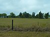
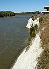
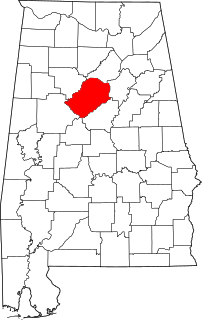
This is intended to be a complete list of the properties and districts on the National Register of Historic Places in Marengo County, Alabama, United States. Latitude and longitude coordinates are provided for many National Register properties and districts; these locations may be seen together in a Google map.[1]
There are 28 properties and districts listed on the National Register in the county, including 1 National Historic Landmark.
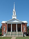
Federal style mansion built in 1832 for Francis Strother Lyon and wife, Sarah Serena Glover, by her father, Allen Glover. Remodeled in the Greek Revival style in the 1840s.
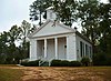
Plantation established by Andrew Pickens Calhoun, son of John C. Calhoun. Sold to Tristram Bethea in 1863, it has remained in the Bethea family to the present day.
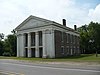
Built by Nathan Bryan Whitfield from 1843 to 1860, this plantation house is considered by architectural historians as one of the most elaborate and significant examples of Greek Revival architecture in Alabama.
This is a list of the National Register of Historic Places listings in Barbour County, Alabama.
This is a list of the National Register of Historic Places listings in Butler County, Alabama.
This is a list of the National Register of Historic Places listings in Calhoun County, Alabama.
This is a list of the National Register of Historic Places listings in Clarke County, Alabama.
This is a list of the National Register of Historic Places listings in Colbert County, Alabama.
This is a list of the National Register of Historic Places listings in Dallas County, Alabama.
This is a list of the National Register of Historic Places listings in Elmore County, Alabama.
This is a list of the National Register of Historic Places listings in Etowah County, Alabama.
This is a list of the National Register of Historic Places listings in Hale County, Alabama.
This is a list of the National Register of Historic Places listings in Jackson County, Alabama.
This is intended to be a complete list of the properties and districts on the National Register of Historic Places in Jefferson County, Alabama, United States. Latitude and longitude coordinates are provided for many National Register properties and districts; these locations may be seen together in an online map.
This is a list of the National Register of Historic Places listings in Lauderdale County, Alabama.
This is a list of the National Register of Historic Places listings in Lee County, Alabama.
This is a list of the National Register of Historic Places listings in Macon County, Alabama.
This is a list of the National Register of Historic Places listings in Marshall County, Alabama.
This is a list of the National Register of Historic Places listings in Montgomery County, Alabama.
This is a list of the National Register of Historic Places listings in Perry County, Alabama.
This is a list of the National Register of Historic Places listings in Russell County, Alabama.
This is a list of the National Register of Historic Places listings in St. Clair County, Alabama.
This is a list of the National Register of Historic Places listings in Sumter County, Alabama.
References
↑ The latitude and longitude information provided in this table was derived originally from the National Register Information System, which has been found to be fairly accurate for about 99% of listings. Some locations in this table may have been corrected to current GPS standards.
↑ Numbers represent an alphabetical ordering by significant words. Various colorings, defined here, differentiate National Historic Landmarks and historic districts from other NRHP buildings, structures, sites or objects.
↑ The eight-digit number below each date is the number assigned to each location in the National Register Information System database, which can be viewed by clicking the number.
This page is based on this Wikipedia article Text is available under the CC BY-SA 4.0 license; additional terms may apply. Images, videos and audio are available under their respective licenses.