
Hurricane Jeanne was a Category 3 hurricane that struck the Caribbean and the Eastern United States in September 2004. It was the deadliest hurricane in the Atlantic basin since Mitch in 1998. It was the tenth named storm, the seventh hurricane, and the fifth major hurricane of the season, as well as the third hurricane and fourth named storm of the season to make landfall in Florida. After wreaking havoc on Hispaniola, Jeanne struggled to reorganize, eventually strengthening and performing a complete loop over the open Atlantic. It headed westwards, strengthening into a Category 3 hurricane and passing over the islands of Great Abaco and Grand Bahama in the Bahamas on September 25. Jeanne made landfall later in the day in Florida just two miles from where Hurricane Frances had struck a mere three weeks earlier.

Hurricane Hilda was an intense tropical cyclone that ravaged areas of the United States Gulf Coast, particularly Louisiana. In addition to its damage inland, the hurricane greatly disrupted offshore oil production, and at its time was the costliest tropical cyclone for Louisiana's offshore oil production. Due in part to flights made by the National Hurricane Research Laboratory, Hilda became one of the most well-documented storms meteorologically in the Atlantic. Lasting for seven days as a tropical cyclone, Hilda caused US$126 million in damage and 38 deaths. It was the tenth named storm, sixth hurricane, and the fourth major hurricane of the 1964 Atlantic hurricane season.

Hurricane Edith was the strongest hurricane to form during the 1971 Atlantic hurricane season and formerly the southernmost landfalling Category 5 hurricane on record in the Atlantic until 2007. Edith also stands as one of the only Category 5 Atlantic hurricanes to not have its name retired, next to 1953's Hurricane Carol, 1961's Hurricane Esther, 2005's Hurricane Emily, and 2019's Hurricane Lorenzo. Edith developed from a tropical wave on September 5 and quickly strengthened into a hurricane in the Caribbean Sea. Edith rapidly intensified on September 9 and made landfall on Cape Gracias a Dios as a Category 5 hurricane on the Saffir-Simpson Hurricane Scale. Being a category 5 hurricane, Edith peaked at only 943 mbar (hPa), making Edith the least intense category 5 Atlantic hurricane on record. It quickly lost intensity over Central America and after briefly entering the Gulf of Honduras it crossed the Yucatán Peninsula in Mexico. After moving across the Gulf of Mexico a trough turned the storm to the northeast and Edith, after having restrengthened while accelerating towards the coast, made landfall on Louisiana with winds of 105 mph (169 km/h) on September 16. Edith steadily weakened over land and dissipated over Georgia on September 18.

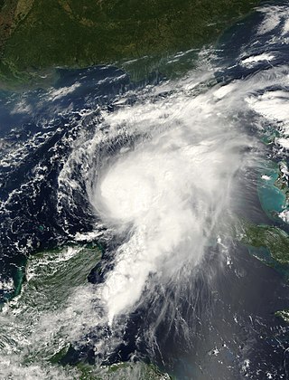
Hurricane Cindy was a tropical cyclone that briefly reached minimal hurricane strength in the Gulf of Mexico during July in the 2005 Atlantic hurricane season and made landfall in Louisiana. It was the third named storm and first hurricane of the season. Cindy was originally thought to have been a tropical storm at peak strength, but was upgraded to a Category 1 hurricane in the post-season analysis. Cindy formed on July 3 just east of the Yucatán Peninsula in the Caribbean Sea. The depression soon made landfall on the peninsula and weakened before reemerging in the Gulf of Mexico on July 4. The storm strengthened as it moved north becoming a hurricane just before making landfall near Grand Isle, Louisiana, on July 5. The storm weakened as it moved overland and became extratropical on July 7.

Hurricane Danny was the only hurricane to make landfall in the United States during the 1997 Atlantic hurricane season, and the second hurricane and fourth tropical storm of the season. The system became the earliest-formed fifth tropical or subtropical storm of the Atlantic season in history when it attained tropical storm strength on July 17, and held that record until the 2005 Atlantic hurricane season when Tropical Storm Emily broke that record by several days. Like the previous four tropical or subtropical cyclones of the season, Danny had a non-tropical origin, after a trough spawned convection that entered the warm waters of the Gulf of Mexico. Danny was guided northeast through the Gulf of Mexico by two high pressure areas, a rare occurrence in the middle of July. After making landfall on the Gulf Coast, Danny tracked across the southeastern United States and ultimately affected parts of New England with rain and wind.
Hurricane Allison was the first named storm and first hurricane of the 1995 Atlantic hurricane season. It was an early season hurricane that delivered heavy rains and caused minor damage, primarily across Cuba, Florida and Georgia.
Tropical Storm Arlene was an unusually large and early-forming tropical storm, being the first of twenty-eight different storms during the 2005 Atlantic hurricane season, which would become the second most active season on record. Tropical Storm Arlene formed near Honduras on June 8 and moved northwards. It crossed western Cuba on June 10 and strengthened to just under hurricane strength before making its final landfall on the Florida Panhandle the next day. The storm weakened as it continued to move north over the United States, becoming extratropical on June 13. Arlene was responsible for two deaths and minor damage.
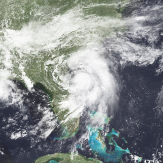
Hurricane Gordon caused minor damage in the Eastern United States. The seventh named storm and fourth hurricane of the 2000 Atlantic hurricane season, Gordon developed in the extreme western Caribbean Sea from a tropical wave on September 14. Shortly thereafter, the depression moved inland over the Yucatán Peninsula and later emerged into the Gulf of Mexico on September 15. The depression began to quickly organize, and by early on September 16, it was upgraded to Tropical Storm Gordon. After becoming a tropical storm, Gordon continued to intensify and was reclassified as a hurricane about 24 hours later; eventually, the storm peaked as an 80 mph (130 km/h) Category 1 hurricane. However, southwesterly upper-level winds caused Gordon to weaken as it approached land, and it was downgraded to a tropical storm by late on September 17. At 0300 UTC on September 18, Gordon made landfall near Cedar Key, Florida as a strong tropical storm. After moving inland, Gordon rapidly weakened and had deteriorated to tropical depression status by nine hours later. Later that day, Gordon merged with a frontal boundary while centered over Georgia.
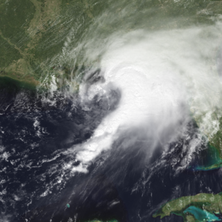
Hurricane Earl was an atypical, disorganized, and short-lived Category 2 hurricane that caused moderate damage throughout the Southeast United States. It formed out of a poorly organized tropical disturbance over the southwest Gulf of Mexico late on August 31, 1998. Tracking towards the northeast, the storm quickly intensified into a hurricane on September 2 and made landfall early the next day near Panama City, Florida. Rapidly tracking towards Atlantic Canada, the extratropical remnants of Earl significantly intensified before passing over Newfoundland on September 6. The remnants were absorbed by former Hurricane Danielle two days later.

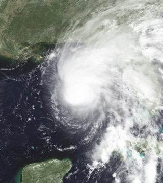
Hurricane Gabrielle was a North Atlantic hurricane that caused flooding in both Florida and Newfoundland in September 2001. It developed in the Gulf of Mexico on the same day as the September 11 attacks; after the attacks, flights were canceled nationwide for two days, and when Gabrielle struck Florida on September 14, it caused a day of additional cancellations. The storm moved ashore with winds of 70 mph (110 km/h) near Venice, a city located south of the Tampa Bay area. The combination of the winds and heavy rainfall, which peaked at 15.1 in (380 mm) in Parrish, left 570,000 customers without power along the west coast and 126,000 customers without power on the east coast. The storm caused about $230 million (2001 USD) in damage in Florida. In the Gulf of Mexico, high waves contributed to two deaths, one of which was indirect; there was also a death due to flooding in Winter Haven.

Tropical Storm Fay was the sixth named storm of the 2002 Atlantic hurricane season; it was a moderate tropical storm which caused flooding in parts of Texas and Northern Mexico. It formed from a trough of low pressure that moved south into the Gulf of Mexico, and became stationary. A low pressure center developed along this trough, and on September 5, a Hurricane Hunter aircraft reported that the system had gained sufficient organization to be classified a tropical depression, 95 miles (153 km) southeast of Galveston. The depression drifted south-southwest while strengthening, reaching its peak strength of 60 miles per hour (97 km/h) on the morning of September 6. The system then made an abrupt turn to the west-northwest, and remained steady in strength and course until landfall the next day, near Matagorda. The system weakened rapidly after landfall degenerating into a remnant low on September 8, but the storm's circulation survived for another three days.

Tropical Storm Bill was a tropical storm that affected the Gulf Coast of the United States in the summer of 2003. The second storm of the 2003 Atlantic hurricane season, Bill developed from a tropical wave on June 29 to the north of the Yucatán Peninsula. It slowly organized as it moved northward, and reached a peak of 60 miles per hour (97 km/h) shortly before making landfall in south-central Louisiana. Bill quickly weakened over land, and as it accelerated to the northeast, moisture from the storm, combined with cold air from an approaching cold front, produced an outbreak of 34 tornadoes. Bill became extratropical on July 2, and was absorbed by the cold front later that day.

Tropical Storm Josephine was an unusual Atlantic tropical storm that moved from west to east across the Gulf of Mexico in October 1996. It formed on October 4 as a tropical depression from the remnants of a cold front. Early in its duration, the system interacted with a ridge over the central United States, which produced strong winds and high tides along the Texas coast. The outer rainbands caused flooding rainfall in southern Texas, and in Louisiana, high tides flooded roads and stranded residents on Grand Isle. Moving generally to the east due to a trough, the depression intensified into a tropical storm on October 6, and the next day reached peak winds of 70 mph (110 km/h) while approaching the west coast of Florida. Josephine made landfall in Taylor County near peak intensity early on October 8, and soon after became extratropical. While moving ashore, the storm produced a high storm surge reaching 9.3 ft (2.8 m) in Suwannee. High tides flooded about 3,600 houses along the west coast. Josephine also produced heavy rainfall, which flooded hundreds of homes, and high winds, which left 400,000 people without power. The storm also spawned at least 16 tornadoes, one of which damaged 130 homes.

Tropical Storm Alberto was the first tropical storm of the 2006 Atlantic hurricane season. Forming on June 10 in the northwestern Caribbean, the storm moved generally to the north, reaching a maximum intensity of 70 mph (110 km/h) before weakening and moving ashore in the Big Bend area of Florida on June 13. Alberto then moved through eastern Georgia, North Carolina, and Virginia as a tropical depression before becoming extratropical on June 14.
Hurricane Bob was the first of six hurricanes to strike the United States during the 1985 Atlantic hurricane season. The second tropical storm and first hurricane of the year, Bob developed from a tropical wave on July 21 in the eastern Gulf of Mexico. Bob began moving east, making landfall southwestern Florida as a weak tropical storm. The storm then turned to the north and quickly intensified to hurricane status on July 24. The next day, it made landfall near Beaufort, South Carolina, becoming one of a record-tying six hurricanes to hit the United States during a single season. Bob quickly weakened over land, and was absorbed by a frontal trough over eastern West Virginia on July 26.

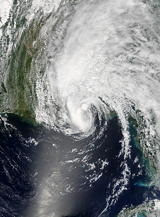
Hurricane Humberto was a Category 1 hurricane that formed and intensified faster than any other North Atlantic tropical cyclone on record, before landfall. The eighth named storm and third hurricane of the 2007 Atlantic hurricane season, Humberto developed on September 12, 2007, in the northwestern Gulf of Mexico. The tropical cyclone rapidly strengthened and struck High Island, Texas, with winds of about 90 mph (140 km/h) early on September 13. It steadily weakened after moving ashore, and on September 14, Humberto began dissipating over northwestern Georgia as it interacted with an approaching cold front.

Tropical Storm Fay was a strong and unusual tropical storm that moved erratically across the state of Florida and the Caribbean Sea. The sixth named storm of the 2008 Atlantic hurricane season, Fay formed from a vigorous tropical wave on August 15 over the Dominican Republic. It passed over the island of Hispaniola, into the Gulf of Gonâve, across the island of Cuba, and made landfall on the Florida Keys late in the afternoon of August 18 before veering into the Gulf of Mexico. It again made landfall near Naples, Florida, in the early hours of August 19 and progressed northeast through the Florida peninsula, emerging into the Atlantic Ocean near Melbourne on August 20. Extensive flooding took place in parts of Florida as a result of its slow movement. On August 21, it made landfall again near New Smyrna Beach, Florida, moving due west across the Panhandle, crossing Gainesville and Panama City, Florida. As it zigzagged from water to land, it became the first storm in recorded history to make landfall in Florida four times. Thirty-six deaths were blamed on Fay. The storm also resulted in one of the most prolific tropical cyclone related tornado outbreaks on record. A total of 81 tornadoes touched down across five states, three of which were rated as EF2. Damage from Fay was heavy, estimated at $560 million.

Tropical Storm Becky was the second tropical cyclone and named storm of the 1970 Atlantic hurricane season. Becky formed from a tropical depression that was designated on July 19. The next day it organized over the Yucatán Channel and became Tropical Storm Becky. Initially thought to have attained minimal hurricane status, Becky reached peak winds of 65 mph (100 km/h), but the storm began to deteriorate shortly thereafter. The storm made landfall on the Florida Panhandle on July 22, and rapidly weakened over land. Overall, damage was related to heavy rainfall that caused flooding in Tallahassee, Florida; 104 families suffered flood-related losses. About $500,000 in damage was attributed to the storm. Further north, the heavy rainfall swelled rivers. Becky may have been partially responsible for spawning tornadoes that destroyed or damaged several houses.


