A storm surge, storm flood, tidal surge, or storm tide is a coastal flood or tsunami-like phenomenon of rising water commonly associated with low-pressure weather systems, such as cyclones. It is measured as the rise in water level above the normal tidal level, and does not include waves.

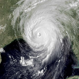
Hurricane Katrina was a devastating Category 5 Atlantic hurricane that resulted in 1,836 fatalities and caused damage estimated between $97.4 billion to $145.5 billion in late August 2005, particularly in the city of New Orleans and its surrounding areas. At the time, it was the costliest tropical cyclone on record, tied now with Hurricane Harvey of 2017. Katrina was the twelfth tropical cyclone, the fifth hurricane, and the third major hurricane of the 2005 Atlantic hurricane season. It was also the fourth-most intense Atlantic hurricane on record that made landfall in the contiguous United States by barometric pressure.

Hurricane preparedness in New Orleans has been an issue since the city's early settlement because of its location.
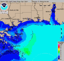
Hurricane Katrina's winds and storm surge reached the Mississippi coastline on the morning of August 29, 2005. beginning a two-day path of destruction through central Mississippi; by 10 a.m. CDT on August 29, 2005, the eye of Katrina began traveling up the entire state, only slowing from hurricane-force winds at Meridian near 7 p.m. and entering Tennessee as a tropical storm. Many coastal towns of Mississippi had already been obliterated, in a single night. Hurricane-force winds reached coastal Mississippi by 2 a.m. and lasted over 17 hours, spawning 11 tornadoes and a 28-foot (8.5 m) storm surge flooding 6–12 miles (9.7–19.3 km) inland. Many, unable to evacuate, survived by climbing to attics or rooftops, or swimming to higher buildings and trees. The worst property damage from Katrina occurred in coastal Mississippi, where all towns flooded over 90% in hours, and waves destroyed many historic buildings, with others gutted to the 3rd story. Afterward, 238 people died in Mississippi, and all counties in Mississippi were declared disaster areas, 49 for full federal assistance. Regulations were changed later for emergency centers and casinos. The emergency command centers were moved higher because all 3 coastal centers flooded at 30 ft (9.1 m) above sea level. Casinos were allowed on land rather than limited to floating casino barges as in 2005.

This article contains a historical timeline of the events of Hurricane Katrina' on August 23–30, 2005 and its aftermath.
Hurricane Katrina struck the United States on August 29, 2005, causing over a thousand deaths and extreme property damage, particularly in New Orleans. The incident affected numerous areas of governance, including disaster preparedness and environmental policy.

Hurricane Rita was the most intense tropical cyclone on record in the Gulf of Mexico and the fourth-most intense Atlantic hurricane ever recorded. Part of the record-breaking 2005 Atlantic hurricane season, which included three of the top ten most intense Atlantic hurricanes in terms of barometric pressure ever recorded, Rita was the seventeenth named storm, tenth hurricane, and fifth major hurricane of the 2005 season. It was also the earliest-forming 17th named storm in the Atlantic until Tropical Storm Rene in 2020. Rita formed near The Bahamas from a tropical wave on September 18, 2005 that originally developed off the coast of West Africa. It moved westward, and after passing through the Florida Straits, Rita entered an environment of abnormally warm waters. Moving west-northwest, it rapidly intensified to reach peak winds of 180 mph (285 km/h), achieving Category 5 status on September 21. However, it weakened to a Category 3 hurricane before making landfall in Johnson's Bayou, Louisiana, between Sabine Pass, Texas and Holly Beach, Louisiana, with winds of 115 mph (185 km/h). Rapidly weakening over land, Rita degenerated into a large low-pressure area over the lower Mississippi Valley by September 26th.

Hurricane Bonnie was a major hurricane that made landfall in North Carolina, inflicting severe crop damage. The second named storm, first hurricane, and first major hurricane of the 1998 Atlantic hurricane season, Bonnie developed from a tropical wave that emerged off the coast of Africa on August 14. The wave gradually developed, and the system was designated a tropical depression on August 19. The depression began tracking towards the west-northwest, and became a tropical storm the next day. On August 22, Bonnie was upgraded to a hurricane, with a well-defined eye. The storm peaked as a Category 3 hurricane on the Saffir-Simpson Hurricane Scale, and around the same time, the storm slowed and turned more towards the north-northwest. A large and powerful cyclone, Bonnie moved ashore in North Carolina early on August 27, slowing as it turned northeast. After briefly losing hurricane status, the storm moved offshore and regained Category 1-force winds, although it weakened again on entering cooler waters.
This article covers the details of the Preparations for Hurricane Katrina, a major category 5 hurricane that devastated parts of New Orleans, Florida, Louisiana, Mississippi, and Alabama, as well as the Hurricane Pam simulation and NWS forecasts that led to the U.S. government's decision to establish a Bipartisan Congressional Committee to investigate the country's preparedness for and response to Hurricane Katrina.

The effects of Hurricane Isabel in North Carolina were widespread, with the heaviest damage in Dare County. The hurricane made landfall in the Outer Banks of North Carolina on September 18. There, storm surge flooding and strong winds damaged thousands of houses. The storm surge produced a 2,000 feet (610 m) wide inlet on Hatteras Island, isolating Hatteras by road for two months. Several locations along North Carolina Highway 12 were partially washed out or covered with debris. Hurricane Isabel produced hurricane-force wind gusts across eastern North Carolina, knocking down trees and power lines. About 700,000 residents lost power due to the storm, although most outages were restored within a few days. The hurricane killed three people in the state – two due to falling trees, and the other a utility worker attempting to restore electricity. Damage in the state totaled $450 million.
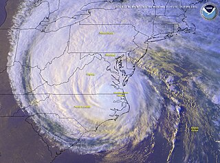
The effects of Hurricane Isabel in Delaware resulted in one of only thirteen presidential disaster declarations for the state of Delaware. Hurricane Isabel formed from a tropical wave on September 6, 2003, in the tropical Atlantic Ocean. It moved northwestward, and within an environment of light wind shear and warm waters, it steadily strengthened to reach peak winds of 165 mph (266 km/h) on September 11. After fluctuating in intensity for four days, Isabel gradually weakened and made landfall on the Outer Banks of North Carolina with winds of 105 mph (169 km/h) on September 18. It quickly weakened over land and became extratropical over Pennsylvania the next day. The storm's center remained to the south and west of Delaware, and was about 175 miles (282 km) from the state at its closest approach. At that time, Isabel was a strong tropical storm located in central Virginia.

In Maryland and Washington, D.C., the effects of Hurricane Isabel were among the most damaging from a tropical cyclone in the respective metropolitan area. Hurricane Isabel formed from a tropical wave on September 6, 2003, in the tropical Atlantic Ocean. It moved northwestward, and within an environment of light wind shear and warm waters, it steadily strengthened to reach peak winds of 165 miles per hour (266 km/h) on September 11. After fluctuating in intensity for four days, Isabel gradually weakened and made landfall on the Outer Banks of North Carolina with winds of 105 miles per hour (169 km/h) on September 18. It quickly weakened over land and became extratropical over western Pennsylvania the next day.
The effects of Hurricane Isabel in Virginia proved to be the costliest disaster in the history of Virginia. Hurricane Isabel formed from a tropical wave on September 6, 2003, in the tropical Atlantic Ocean. It moved northwestward, and within an environment of light wind shear and warm waters it steadily strengthened to reach peak winds of 265 km/h (165 mph) on September 11. After fluctuating in intensity for four days, Isabel gradually weakened and made landfall on the Outer Banks of North Carolina with winds of 165 km/h (103 mph) on September 18. It quickly weakened over land as it passed through central Virginia, and Isabel became extratropical over western Pennsylvania on September 19.
Tropical cyclone forecasting is the science of forecasting where a tropical cyclone's center, and its effects, are expected to be at some point in the future. There are several elements to tropical cyclone forecasting: track forecasting, intensity forecasting, rainfall forecasting, storm surge, tornado, and seasonal forecasting. While skill is increasing in regard to track forecasting, intensity forecasting skill remains unchanged over the past several years. Seasonal forecasting began in the 1980s in the Atlantic basin and has spread into other basins in the years since.

The effects of Hurricane Dennis in Florida included 14 deaths and $1.5 billion in damage. The tropical wave that became Hurricane Dennis formed on June 29, 2005, and proceeded westward across the Atlantic Ocean. It became a tropical depression on July 4, a tropical storm on July 5, and a hurricane on July 7. Dennis rapidly intensified to attain Category 4 status on the Saffir-Simpson Hurricane Scale, and made landfall in Cuba where it weakened to Category 1 status, before re-emerging in the Gulf of Mexico and re–intensifying. The storm made landfall as a Category 3 hurricane on Santa Rosa Island on July 10.
The Effects of Hurricane Dennis in Alabama included $127 million (2005 USD) in damage and three injuries. Dennis made landfall on the Florida Panhandle as a Category 3 hurricane on the Saffir-Simpson scale on July 10, 2005, before tracking over Alabama as a minimal hurricane. In preparation for the storm, about 500,000 people were given evacuation orders, and the Red Cross opened 87 shelters. As a result, all southbound lanes of Interstate 65 from Mobile to Montgomery were closed.
The effects of Hurricane Georges in Louisiana included $30.1 million in damage and three deaths. Forming from a tropical wave over the Atlantic Ocean, Georges attained a peak intensity of 155 mph (249 km/h) on September 20, 1998. Over the following several days, the storm tracked through the Greater Antilles and later entered the Gulf of Mexico on September 28, the Category 2 storm made landfall in Mississippi before dissipating on October 1. Before landfall, about 500,000 residents in Louisiana evacuated from low-lying areas. The mayor of New Orleans declared a state of emergency to allow federal assistance into the state. After nearly 1.5 million people were urged to evacuate coastal areas, officials described the evacuation as "probably the largest [...] we have ever achieved".
The effects of Hurricane Georges in Mississippi included $676.8 million in damages but no fatalities. Hurricane Georges was a Category 2 storm at landfall in Mississippi during the 1998 Hurricane season.

Hurricane evacuation is the immediate and rapid movement of people away from the threat or actual occurrence of a hurricane. County judges, emergency managers and other officials may recommend a voluntary evacuation or order a mandatory evacuation.

The effects of Hurricane Isaac in Louisiana were more severe than anywhere in the storm's path, and included $611.8615 million in damages and five total deaths. Forming from a tropical wave in the central Atlantic, Isaac traversed across many of the Lesser and Greater Antilles, before reaching peak intensity with winds of 80 mph (130 km/h) on August 28, 2012 while in the Gulf of Mexico. Nearing the coast of Louisiana, the Category 1 hurricane slowly moved towards the west, making two landfalls in the state with little change of intensity prior to moving inland for a final time. The hurricane weakened and later dissipated on September 1 while over Missouri. Before landfall, Governor Bobby Jindal declared a state of emergency to the state, as well as ordering the mandatory evacuation of 60,000 residents in low-lying areas of Louisiana along the Tangipahoa River in Tangipahoa Parish.