Tropical storm (39–73 mph, 63–118 km/h)
Category 1 (74–95 mph, 119–153 km/h)
Category 2 (96–110 mph, 154–177 km/h)
Category 3 (111–129 mph, 178–208 km/h)
Category 4 (130–156 mph, 209–251 km/h)
Category 5 (≥157 mph, ≥252 km/h)
Unknown
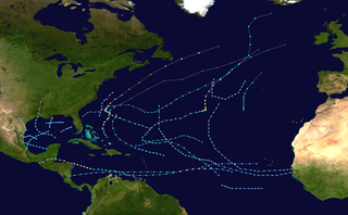
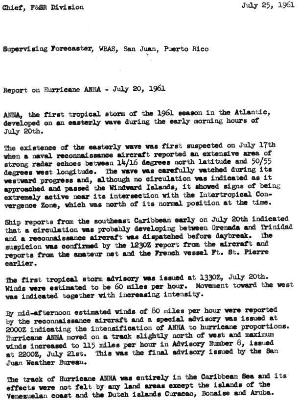
The origins of Hurricane Anna were likely from an easterly wave located over Africa. On July 16, Television Infrared Observation Satellite (TIROS) imagery showed a cloud mass situated about 1,020 miles (1,640 km) west-southwest of the southernmost islands of Cape Verde. [1] The existence of an easterly wave was not confirmed by United States Navy reconnaissance aircraft and ship reports until the following day, at which time the system was located over 445 miles (716 km) east of Antigua. Although no circulation existed while the wave approached the Windward Islands, significant amounts of deep convection was associated with the system and located near the Intertropical Convergence Zone (ITCZ). Early on July 20, ship reports indicated a developing circulation between Grenada and Trinidad; [2] squalls on the former island produced wind gusts as strong as 50 mph (80 km/h). [3] According to HURDAT – the North Atlantic hurricane database – the system developed into Tropical Storm Anna at 0000 UTC on July 20, [4] as confirmed by a reconnaissance aircraft flight. [3]
Situated about 25 miles (40 km) east-northeast of Tobago with an initial wind speed of 40 mph (64 km/h), [4] Anna immediately began to strengthen while moving slightly north of due west. The first advisory on Anna, issued at 1330 UTC on July 20, reported sustained winds of 60 mph (97 km/h). Later that day, the storm was upgraded to a hurricane after a reconnaissance aircraft reported hurricane-force winds. [2] Anna then deepened more steadily, becoming a Category 2 hurricane early on July 21. At 1200 UTC on the next day, Anna attained its peak intensity with maximum sustained winds of 105 mph (169 km/h) and a minimum barometric pressure of 976 mbar (28.8 inHg ). Early on July 23, Anna weakened to a Category 1 hurricane while approaching the northern coast of Honduras. Around 12:00 UTC on the following day, Anna made landfall in a rural area of Stann Creek District, Belize, with winds of 80 mph (130 km/h). Late on July 24, the system weakened to a tropical storm and then dissipated. [4]
Preparations
The United States Weather Bureau issued tropical cyclone watches and warnings for Venezuela, Curaçao, Bonaire and Aruba. [5] In Jamaica, meteorologists forecast that the storm would bypass the island to the south without causing any effects. [6] As Anna continued westward, it was predicted to make landfall in either northern Nicaragua or southeastern Honduras. Residents in those countries were advised to take precautions ahead of the storm. [7] [8] Central Americans residing along Gulf of Honduras were also warned about 10 feet (3.0 m) tides and strong winds. [9] As the storm neared Honduras, small boats and other water craft were advised to remain in port. [10] Additionally, a hurricane watch was posted for the Swan Islands. [11] In Belize, the threat of the storm forced 100 residents to evacuate their homes, while numerous businesses were closed down. At Belize Harbor, many ships and boats were moved upstream inland. [12] The hurricane was also forecast to bring heavy rainfall to the mountainous areas of Belize, causing a concern for flash flooding. [13] Additionally, Belize's Church Welfare Service began to ship clothing and other materials in anticipation of the hurricane. [12]
Impact

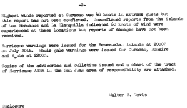
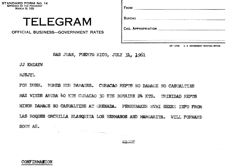
In Grenada, Anna produced wind gusts of 50 mph (80 km/h). [3] Damage from the storm's impact on Grenada was limited to banana crops, trees, and telephone poles. [6] Winds were light on Barbados and Saint Lucia, reaching only 29 mph (47 km/h) on both islands. [1] Damage on Trinidad was minor. [14] In northern Venezuela and the ABC Islands, the storm produced winds of 50–70 mph (80–113 km/h) in Curaçao, Los Hermanos and La Blanquilla; [5] A weather station in Aruba reported winds of 50 mph (80 km/h). [14]
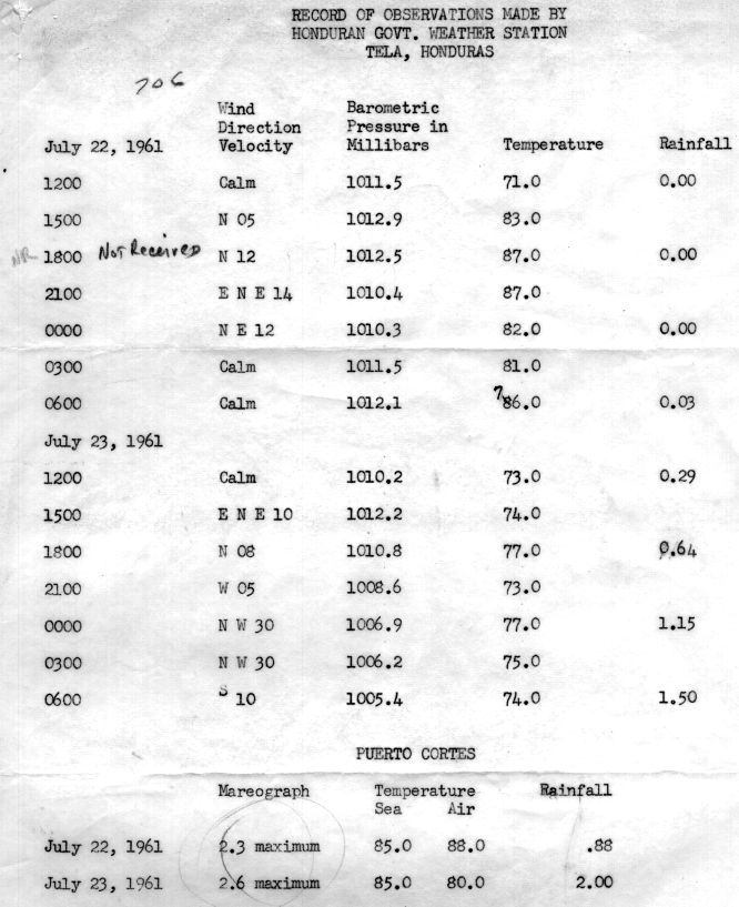
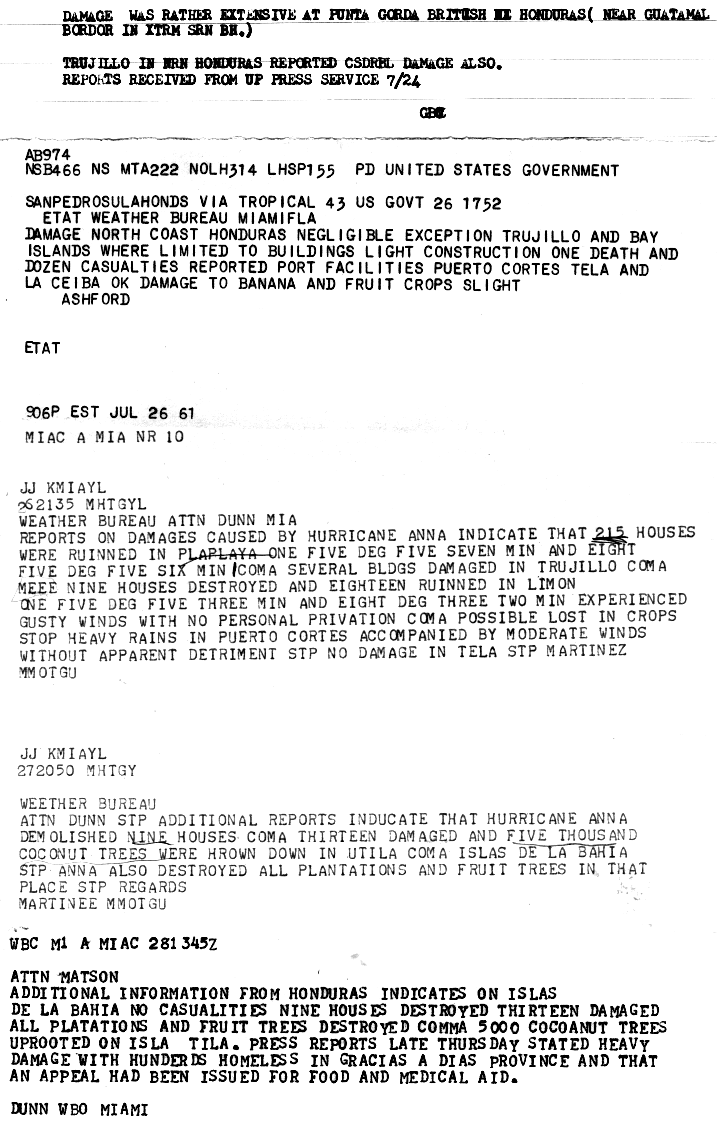
In Honduras, damage from Anna was moderate and limited to the Atlantic coast. A weather station in Tela recorded rainfall of 0.29–1.5 inches (7.4–38.1 millimetres) over a two-day period, and another station in Puerto Cortés measured 2 inches (51 mm). [15] In Plaplaya, the storm damaged 215 homes. In Trujillo, a number of buildings suffered damage. [16] At Limón, nine houses were destroyed and eighteen more were left uninhabitable. [16] Serious damage also occurred in Gracias a Dios Department, where hundreds of people were left homeless. [17] On the Bay Islands, nine houses were demolished and thirteen suffered damage. High winds toppled about 5,000 coconut trees on Útila. [16] Damage from Anna in Honduras amounted to $300,000. [3] One person drowned and 12 other were injured, and victims required food and medical aid in Anna's wake. [17] In Belize, Anna produced waves 7–10 ft (2.1–3.0 m) and gusty winds. [13] Though unspecific, there were reports of considerable damage in the country. [3]
See also
Notes
- ↑ All damage figures are in 1961 United States dollar, unless otherwise noted
Related Research Articles

The 1995 Atlantic hurricane season was a very active Atlantic hurricane season, and is considered to be the start of an ongoing era of high-activity tropical cyclone formation. The season produced twenty-one tropical cyclones, nineteen named storms, as well as eleven hurricanes and five major hurricanes. The season officially began on June 1 and ended on November 30, dates which conventionally delimit the period of each year when most tropical cyclones develop in the Atlantic basin. The first tropical cyclone, Hurricane Allison, developed on June 2, while the season's final storm, Hurricane Tanya, transitioned into an extratropical cyclone on November 1. The very active Atlantic hurricane activity in 1995 was caused by La Niña conditions, which also influenced an inactive Pacific hurricane season. It was tied with 1887 Atlantic hurricane season with 19 named storms. And was later in 2010, 2011, and 2012 seasons respectively.

The 1999 Atlantic hurricane season was a fairly active season, mostly due to a persistent La Niña that developed in the latter half of 1998. It had five Category 4 hurricanes – the highest number recorded in a single season in the Atlantic basin, previously tied in 1933 and 1961, and later tied in 2005 and 2020. The season officially began on June 1, and ended on November 30. These dates conventionally delimit the period of each year when most tropical cyclones form in the Atlantic basin. The first storm, Arlene, formed on June 11 to the southeast of Bermuda. It meandered slowly for a week and caused no impact on land. Other tropical cyclones that did not affect land were Hurricane Cindy, Tropical Storm Emily, and Tropical Depression Twelve. Localized or otherwise minor damage occurred from Hurricanes Bret, Gert, and Jose, and tropical storms Harvey and Katrina.

The 1960 Atlantic hurricane season was the least active season since 1952. The season officially began on June 15, and lasted until November 15. These dates conventionally delimit the period of each year when most tropical cyclones form in the Atlantic basin. The first system, an unnamed storm, developed in the Bay of Campeche on June 22. It brought severe local flooding to southeastern Texas and was considered the worst disaster in some towns since a Hurricane in 1945. The unnamed storm moved across the United States for almost a week before dissipating on June 29. In July, Hurricane Abby resulted in minor damage in the Leeward Islands, before impacting a few Central American counties — the remnants of the storm would go on to form Hurricane Celeste in the East Pacific. Later that month, Tropical Storm Brenda caused flooding across much of the East Coast of the United States. The next storm, Hurricane Cleo, caused no known impact, despite its close proximity to land.

The 1961 Atlantic hurricane season was a very active Atlantic hurricane season, with an accumulated cyclone energy (ACE) total of 189. The season, however, was an average one in terms of named storms. The season featured eight hurricanes and a well above average number of five major hurricanes. It was previously thought that the season had a record-tying seven major hurricanes, before the Atlantic hurricane reanalysis project downgraded two storms in 2019. Two Category 5 hurricanes were seen in 1961, making it one of only seven Atlantic hurricane seasons to feature multiple Category 5 hurricanes in one season. The season started on June 15, and ended on November 15. These dates conventionally delimit the period of each year when most tropical cyclones form in the Atlantic basin. The first system, an operationally unclassified tropical depression, formed offshore east Central Florida on June 10, but dissipated a few days later. Next, Hurricane Anna developed in the eastern Caribbean Sea near the Windward Islands on July 20. It brought minor damage to the islands, as well as wind and flood impacts to Central America after striking Belize as a hurricane. Anna caused one death and about $300,000 (1961 USD) in damage. Activity went dormant for nearly a month and a half, until Hurricane Betsy developed on September 2. Betsy peaked as a Category 4 hurricane, but remained at sea and caused no impact.

The 1969 Atlantic hurricane season was the most active Atlantic hurricane season since the 1933 season, and was the final year of the most recent positive ("high-quality") Atlantic multidecadal oscillation (AMO) era. The hurricane season officially began on June 1, and lasted until November 30. The season had the highest number of systems reach hurricane status – twelve – in a single season, until that record was surpassed in 2005. The season was above-average despite an El Niño, which typically suppresses activity in the Atlantic Ocean, while increasing tropical cyclone activity in the Pacific Ocean. Activity began with a tropical depression that caused extensive flooding in Cuba and Jamaica in early June. On July 25, Tropical Storm Anna developed, the first named storm of the season. Later in the season, Tropical Depression Twenty-Nine caused severe local flooding in the Florida Panhandle and southwestern Georgia in September.
The 1978 Atlantic hurricane season was a slightly above average hurricane season in terms of number of named storms. Eleven tropical cyclones were named in all, and five of these became hurricanes; two of the five became a major hurricane. This was also the last Atlantic hurricane season to use an all-female naming list. The season officially began on June 1, 1978, and ended on November 30, 1978. These dates, adopted by convention, denote the period in each year when most tropical cyclogenesis occurs in the Atlantic basin. However, the formation of subtropical or tropical cyclones is possible at any time of the year, as shown by the formation of an unnamed subtropical storm on January 18.

The 1985 Atlantic hurricane season had six United States landfalling hurricanes, tied with 1886 and 2020 for the highest number on record. The season officially began on June 1 and lasted until November 30. It was an average season, with 11 named storms developing. This was partially attributed to a La Niña – a meteorological phenomenon that produces favorable conditions across the Atlantic basin, such as lower wind shear and higher sea surface temperatures. The first storm, Ana, developed on July 15 near Bermuda and caused minor effects in Canada while transitioning into an extratropical cyclone. Three other tropical cyclones – Claudette, Henri, and Isabel – did not significantly affect land. Claudette developed offshore of the Southeastern United States and brushed Bermuda and the Azores. Henri and Isabel were dissipating as they approached land. However, the precursor of the latter caused a severe flood in Puerto Rico that killed 180 people. Additionally, Tropical Storm Fabian and three tropical depressions did not have any known impact on land.
Hurricane Hattie was the strongest and deadliest tropical cyclone of the 1961 Atlantic hurricane season, reaching peak intensity as a Category 5 hurricane. The ninth tropical storm, seventh hurricane, fifth major hurricane, and second Category 5 of the season, Hattie originated from an area of low pressure that strengthened into a tropical storm over the southwestern Caribbean Sea on October 27. Moving generally northward, the storm quickly became a hurricane and later major hurricane the following day. Hattie then turned westward west of Jamaica and strengthened into a Category 5 hurricane, with maximum sustained winds of 165 mph (270 km/h). It weakened to Category 4 before making landfall south of Belize City on October 31. The storm turned southwestward and weakened rapidly over the mountainous terrain of Central America, dissipating on November 1.

The 1945 Atlantic hurricane season produced multiple landfalling tropical cyclones. It officially began on June 16 and lasted until October 31, dates delimiting the period when a majority of storms were perceived to form in the Atlantic Ocean. A total of 11 systems were documented, including a late-season cyclone retroactively added a decade later. Five of the eleven systems intensified into hurricanes, and two further attained their peaks as major hurricanes. Activity began with the formation of a tropical storm in the Caribbean on June 20, which then made landfalls in Florida and North Carolina at hurricane intensity, causing one death and at least $75,000 in damage. In late August, a Category 3 hurricane on the modern-day Saffir–Simpson hurricane wind scale struck the Texas coastline, with 3 deaths and $20.1 million in damage. The most powerful hurricane of the season, reaching Category 4 intensity, wrought severe damage throughout the Bahamas and East Coast of the United States, namely Florida, in mid-September; 26 people were killed and damage reached $60 million. A hurricane moved ashore the coastline of Belize in early October, causing one death, while the final cyclone of the year resulted in 5 deaths and $2 million in damage across Cuba and the Bahamas two weeks later. Overall, 36 people were killed and damage reached at least $82.85 million.

The 1931 Atlantic hurricane season was an active hurricane season, with a total of 13 storms recorded, which was the most since 1916. However, only three of them intensified into hurricanes and just one reached major hurricane intensity, which is Category 3 or higher on the modern-day Saffir–Simpson scale. Nine of the tropical cyclones were identified in real-time, while evidence of the existence of four other tropical cyclones was uncovered by the Atlantic hurricane reanalysis project in 2012 and added to the Atlantic hurricane database. Additionally, two of the tropical storms were upgraded to hurricane status as part of the reanalysis.

The 1926 Atlantic hurricane season featured the highest number of major hurricanes at the time. At least eleven tropical cyclones developed during the season, all of which intensified into a tropical storm and eight further strengthened into hurricanes. Six hurricanes deepened into a major hurricane, which is Category 3 or higher on the modern-day Saffir–Simpson hurricane wind scale. It was a fairly active and deadly season. The first system, the Nassau hurricane, developed near the Lesser Antilles on July 22. Moving west-northwest for much of its duration, the storm struck or brush several islands of the Lesser and Greater Antilles. However, the Bahamas later received greater impact. At least 287 deaths and $7.85 million (1926 USD) in damage was attributed to this hurricane. The next cyclone primarily affected mariners in and around the Maritimes of Canada, with boating accidents and drownings resulting in between 55 and 58 fatalities. In late August, the third hurricane brought widespread impact to the Gulf Coast of the United States, especially Louisiana. Crops and buildings suffered $6 million in damage and there were 25 people killed.

The 1921 Atlantic hurricane season was an active hurricane season, with 12 tropical cyclones forming. Among them, seven became tropical storms, of which five strengthened into hurricanes. Furthermore, two of these strengthened into a major hurricane, Category 3 or higher on the modern-day Saffir–Simpson hurricane wind scale, the most since the 1917 season. The first system, a tropical depression, developed on June 1, while the last, a tropical storm, dissipated on November 25. Of note, three tropical cyclones co-existed with another during the season.

The 1901 Atlantic hurricane season was the most active season without a major hurricane – tropical cyclones that reach at least Category 3 on the Saffir–Simpson hurricane wind scale – until 2013. The first system was initially observed in the northeastern Caribbean on June 11. The fourteenth and final system transitioned into an extratropical cyclone near Bermuda on November 5. These dates fall within the period with the most tropical cyclone activity in the Atlantic. Eight of the fourteen tropical cyclones existed simultaneously.

The 1899 Atlantic hurricane season featured the longest-lasting tropical cyclone in the Atlantic basin on record. There were nine tropical storms, of which five became hurricanes. Two of those strengthened into major hurricanes, which are Category 3 or higher on the modern day Saffir–Simpson hurricane wind scale. The first system was initially observed in the northeastern Gulf of Mexico on June 26. The tenth and final system dissipated near Bermuda on November 10. These dates fall within the period with the most tropical cyclone activity in the Atlantic. In post-season analysis, two tropical cyclones that existed in October were added to HURDAT – the official Atlantic hurricane database. At one point during the season, September 3 through the following day, a set of three tropical cyclones existed simultaneously.

The 1893 Atlantic hurricane season ran through the summer and the first half of fall in 1893. The 1893 season was fairly active, with 12 tropical storms forming, 10 of which became hurricanes. Of those, five became major hurricanes. This season proved to be a very deadly season, with two different hurricanes each causing over 2,000 deaths in the United States; at the time, the season was the deadliest in U.S. history. The season was one of two seasons on record to see four Atlantic hurricanes active simultaneously, along with the 1998 Atlantic hurricane season. Additionally, August 15, 1893 was the only time since the advent of modern record keeping that three storms have formed on the same day until 2020 saw Wilfred, Alpha, and Beta forming on the same day; and for the first time, there were two high-intensity hurricanes simultaneously in one month of August, and this was not repeated until the year 2023.

The 2008 Atlantic hurricane season was the most destructive Atlantic hurricane season since 2005, causing over 1,000 deaths and nearly $50 billion in damage. The season ranked as the third costliest ever at the time, but has since fallen to ninth costliest. It was an above-average season, featuring sixteen named storms, eight of which became hurricanes, and five which further became major hurricanes. It officially started on June 1 and ended on November 30. These dates conventionally delimit the period of each year when most tropical cyclones form in the Atlantic basin. However, the formation of Tropical Storm Arthur caused the season to start one day early. It was the only year on record in which a major hurricane existed in every month from July through November in the North Atlantic. Bertha became the longest-lived July tropical cyclone on record for the basin, the first of several long-lived systems during 2008.

The 1932 San Ciprián hurricane was one of the strongest tropical cyclones in the history of Puerto Rico. The center of the storm traversed the island on an east-to-west path in late September 1932, killing 272 people and inflicting at least $35 million in damage. Winds in San Juan, Puerto Rico, were estimated to have reached at least 120 mph (190 km/h), causing extensive destruction. The storm's origins can be traced back to at least September 25, 1932, when it was a tropical storm east of the Windward Islands. Moving west as a compact tropical cyclone, it rapidly intensified as it moved across the Virgin Islands the following day before ultimately making landfall on September 27 in Ceiba, Puerto Rico, at a peak intensity equivalent to that of a Category 4 hurricane on the modern Saffir–Simpson scale. The hurricane diminished for the remainder of its duration, leaving Puerto Rico and brushing the southern coast of Hispaniola. The cyclone passed near Jamaica on September 29 and moved ashore British Honduras on October 1 as a tropical storm, dissipating the next day over southeastern Mexico.

The 1931 British Honduras hurricane was the deadliest hurricane in the history of British Honduras, killing an estimated 2,500 people. The hurricane was first detected as a tropical wave off the west coast of Africa on 29 August. Moving westward, the disturbance remained relatively weak until 6 September, when it was first classified as a tropical cyclone just west of the Windward Islands. The depression gradually intensified, reaching tropical storm intensity within the first six hours following tropical cyclogenesis. The cyclone intensified further to hurricane intensity by 8 September. Strengthening and organisation remained gradual until the storm reached the Gulf of Honduras, by which time it began to rapidly intensify, reaching Category 4 hurricane intensity on 10 September. The hurricane subsequently made landfall in Belize City with maximum sustained winds of 130 mph (215 km/h). Moving across the Yucatán Peninsula, the tropical cyclone weakened, and continued to do so when it moved across the Bay of Campeche. This track brought it to a second landfall north of Tampico, Mexico, as a tropical storm on 13 September. Once inland, the storm quickly weakened and dissipated later that day.

Hurricane Abby was the only tropical cyclone in the Caribbean Sea during the 1960 Atlantic hurricane season. The second tropical cyclone and first named storm of the season, Abby developed on July 10 from a tropical wave in the vicinity of the Lesser Antilles. Abby rapidly intensified into a hurricane after being a tropical storm for less than six hours. It briefly peaked as a category 2 hurricane before weakening back. Abby rapidly weakened to a minimal tropical storm a few days thereafter. The storm re-strengthened into a hurricane as it began to parallel the coast of Honduras. Hurricane Abby made landfall in British Honduras on July 15. Abby dissipated over Mexico later the next day. The remnants of Abby ultimately became Hurricane Celeste in the Pacific Ocean. Despite passing through or near several countries, Hurricane Abby had a relatively light impact on land, resulting in just $640,500 in damage and six fatalities.

Hurricane Edith brought flooding and wind damage to portions of the Greater and Lesser Antilles. The sixth tropical storm and fifth hurricane of the 1963 season, Edith developed east of the Windward Islands on September 23 from an Intertropical Convergence Zone (ITCZ) disturbance. Initially a tropical depression, it strengthened into Tropical Storm Edith the next day. Shortly thereafter, Edith reached hurricane status. Edith fluctuated between Category 1 and 2 status as it moved west-northwest. Upon reaching Category 2 intensity on September 25, the storm peaked with winds of 100 mph (155 km/h). After striking Saint Lucia on September 25, the storm traversed the eastern Caribbean Sea. Curving north-northwest on September 26, Edith made landfall near La Romana, Dominican Republic, early on the following day as a minimal hurricane. Interaction with land and an upper-level trough caused Edith to weaken to a tropical storm on September 28 and to a tropical depression by the next day. The storm dissipated just east of the Bahamas on September 29.
References
- 1 2 Fritz, Sigmund (December 1962). "Satellite Pictures And The Origin Of Hurricane Anna" (PDF). Monthly Weather Review. Washington, D.C.: American Meteorological Society, PDF document hosted by National Oceanic and Atmospheric Administration. 90 (12): 507–513. Bibcode:1962MWRv...90..507F. doi:10.1175/1520-0493(1962)090<0507:SPATOO>2.0.CO;2 . Retrieved December 2, 2013.
- 1 2 Higgs, Ralph L. (August 4, 1961). Report on Hurricane Anna – July 20, 1961 (Report). San Juan, Puerto Rico: San Juan Weather Bureau Office, as archived by the National Hurricane Center. p. 1. Retrieved December 2, 2013.
- 1 2 3 4 5 Dunn, Gordon E. (March 1962). "The Hurricane Season of 1961" (PDF). Monthly Weather Review. Miami, Florida: American Meteorological Society, PDF document hosted by National Oceanic and Atmospheric Administration. 90 (3): 108, 110. Bibcode:1962MWRv...90..107D. doi: 10.1175/1520-0493(1962)090<0107:THSO>2.0.CO;2 . Retrieved December 2, 2013.
- 1 2 3 "Atlantic hurricane best track (HURDAT version 2)" (Database). United States National Hurricane Center. April 5, 2023. Retrieved January 20, 2024.
 This article incorporates text from this source, which is in the public domain.
 - 1 2 Ralph L. Higgs (August 4, 1961). Report on Hurricane Anna - July 20, 1961. U.S. Weather Bureau Office San Juan, Puerto Rico (Report). San Juan, Puerto Rico: National Oceanic and Atmospheric Administration; National Hurricane Center. p. 2. Retrieved December 2, 2013.
- 1 2 "Anna Should Miss Jamaica". The Daily Gleaner . 1961.
- ↑ "Hurricane's Sight Set on North Coast of Nicaragua". The Daily Courier . United Press International. 1961.
- ↑ "Hurricane Roars Across Caribbean". Arizona Daily Sun . Associated Press. July 22, 1961 – via Newspapers.com.
- ↑ "Anna Bites At British Honduras". The Miami News . July 23, 1961. Retrieved March 9, 2020– via Newspapers.com.
- ↑ "Hurricanes Path Leading to Honduras". Sunday Gazette-Mail . United Press International. 1961.
- ↑ "Hurricane Aims At Honduras; Warnings Out". The Palm Beach Post . United Press International. July 23, 1961. Retrieved March 9, 2020– via Newspapers.com.
- 1 2 "Anna British Honduras Bound last night". The Daily Gleaner. 1961.
- 1 2 "Hurricane Anna hits Honduras". Great Bend Daily Tribune. Associated Press. July 24, 1961 – via Newspapers.com.
- 1 2 Ralph L. Higgs (August 4, 1961). Report on Hurricane Anna - July 20, 1961. U.S. Weather Bureau Office San Juan, Puerto Rico (Report). San Juan, Puerto Rico: National Oceanic and Atmospheric Administration; National Hurricane Center. p. 11. Retrieved December 3, 2013.
- ↑ Record Of Observations Made By Honduran Govt. Weather Station Tela, Honduras. Tela Railroad Co. (Report). San Juan, Puerto Rico: National Oceanic and Atmospheric Administration; National Hurricane Center. July 27, 1961. p. 2. Retrieved December 3, 2013.
- 1 2 3 Etat; Gordon E. Dunn (August 4, 1961). Report on Hurricane Anna. U.S. Weather Bureau Office Miami, Florida (Report). Miami, Florida: National Oceanic and Atmospheric Administration; National Hurricane Center. p. 11. Retrieved December 3, 2013.
{{cite report}}: CS1 maint: multiple names: authors list (link) - 1 2 "Miami Gets Pelted With Short Storms". The Miami News. July 27, 1961. Retrieved March 9, 2020– via Newspapers.com.
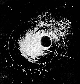
 Anna near peak intensity on July 21 |
| |||||||||||||||||||||
Tropical cyclones of the 1961 Atlantic hurricane season | ||
|---|---|---|
 | ||