Hurricane Alice was the second-strongest Atlantic hurricane to make landfall in the month of June since reliable records began in the 1850s. The storm was linked to catastrophic flooding in southern Texas and northern Mexico,especially along the Rio Grande and its tributaries. The third tropical cyclone and first hurricane of the 1954 Atlantic hurricane season,Alice was one of two storms to receive the same name that year,the other being an unusual post-season hurricane that persisted into the new year of 1955,becoming one of only two January hurricanes on record (the other having formed in 1938). The first Alice developed rather suddenly on June24 over the Bay of Campeche,though it may well have formed earlier but went undetected due to limited surface weather observations. Moving northwestward,Alice strengthened rapidly as it neared the Mexican coastline,becoming a hurricane early the next day. By midday on June25,the hurricane reached peak winds of 110miles per hour (177km/h) before moving inland well south of the U.S.–Mexico border. The storm struck an area with few inhabitants and caused relatively minimal impacts from wind near the point of landfall and in southern Texas.
As it moved inland,however,Alice produced prolific rains along and near the Rio Grande,resulting in some of the worst flooding ever seen in parts of northern Mexico and southern Texas;[1] in some areas,the flooding amounted to a one-in-1,000-year event. The Pecos River crested at 96.24ft (29.33m),which joined with the Rio Grande to produce significant flooding. The floods destroyed bridges and dikes and flooded many cities along the inner reaches of the river,which reached its highest water levels since 1865. As the river overflowed its banks,floods breached the dikes at Piedras Negras,Coahuila,destroying large sections of the town. Other communities in Mexico reported significant flood damage. In the United States,damage was heaviest in Ozona,Texas,where the floods killed 15people and caused $2million in damage (1954USD). Rainfall peaked at over 24.07in (611mm),most of which fell in a 24‑hour period. In all,flooding from Hurricane Alice killed at least 55 people,including 17 in the U.S. and 38 in Mexico,though many deaths in rural Mexico may have gone unreported;the total death toll could have exceeded 150.
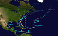
Meteorological history
Map plotting the storm's track and intensity,according to the Saffir–Simpson scale
At 12:00 UTC on June24, 1954, a moderate tropical storm formed about 270 miles (435km) east of Tampico, Tamaulipas, with winds of 60 miles per hour (97km/h).[2] In 2015, NOAA researchers working on reanalysis with the Hurricane Research Division examined observations to determine whether Alice formed earlier, but were unsuccessful due to sparse surface weather observations over the Bay of Campeche.[3] The first observation of gale-force winds occurred at 18:00 UTC on June24, when a ship reported 60-mile-per-hour (97km/h) winds and an atmospheric pressure of 999 millibars (29.50inHg), indicating a well-developed cyclone in the area. Based on these data, scientists concluded that Alice likely formed earlier than indicated, but went undetected until that day.[3] Regardless, Alice steadily intensified almost immediately upon detection as it headed northwestward, strengthening into the equivalent of a Category1 hurricane on the Saffir-Simpson hurricane wind scale by 00:00 UTC on June25.[4][2] Early on that day, a ship calibrated the rapid strengthening of the storm, measuring winds of 85mph (137km/h) at 08:17 UTC.[3] As Alice neared the coast of Mexico, reconnaissance aircraft known as Hurricane Hunters began tracking the eye of the hurricane, but apparently did not penetrate the center of the storm. They did, however, provide information about the position of the storm.[3]
The storm continued to intensify rapidly as it approached the coastline south of the United States–Mexico border. Based on aircraft observations, research suggests that Alice made landfall about 60mi (97km) south of Matamoros, Tamaulipas, at 14:00 UTC on June25.[3][2] The storm affected a thinly populated segment of the Mexican coastline, and few observations were available to determine the strength of the hurricane. One report, taken about 100mi (161km) south of Brownsville, Texas, suggested top winds of at least 70 to 80mph (113 to 129km/h).[4] Prior to scientific reexamination, HURDAT—the official database containing tracks and intensities of cyclones in the North Atlantic and Eastern North Pacific regions—listed top winds of 80mph (129km/h) at landfall in Mexico.[3] However, a radiosonde, launched from Brownsville in time for the 12:00 UTC observation, recorded winds of 150mph (241km/h) from the southeast at 3,000 feet (914m) in elevation. Based on this measurement, which may have represented winds in the eyewall, researchers determined that Hurricane Alice was likely significantly stronger at landfall than previously assessed.[3] They analyzed Alice as having struck Mexico with winds of 110mph (177km/h), while noting the great uncertainty and the possibility that the storm may have even been much stronger than this.[2] The central pressure in the eye was probably 975mb (28.79inHg) or lower, as corroborated by observations well inland in Texas.[3] Therefore, Alice was at least equivalent to a high-end Category2 hurricane at landfall and conceivably could have attained major hurricane status.
After landing, Hurricane Alice gradually weakened as it approximately followed the Rio Grande, crossing into southern Texas near La Grulla just before 00:00 UTC on June26.[2] The storm by then had weakened back to a moderate tropical storm with winds of 60mph (97km/h), but it still produced gale-force winds in several communities across southern Texas; a few areas in Texas may have even experienced hurricane-force winds for brief periods before the storm entered the state, but there are no observations to confirm such winds.[3] The storm likely caused winds of at least 70mph (113km/h) in southern Texas. As it crossed into Texas, Tropical Storm Alice curved more to the north-northwest early on June26 before assuming a sharp bend back westward later in the day.[2] The storm degenerated into a tropical depression by 18:00 UTC and dissipated early on June27 near the Big Bend National Park in Texas.[4][2]
Impact
Storm total rainfall from Hurricane Alice in the United States
Before Alice moved ashore, about 50Girl Scouts at a camp were evacuated to a center in Brownsville, Texas.[5] The residents of Padre Island were also evacuated. Residents in the storm's path were unprepared due to the storm forming suddenly. The United States Coast Guard spread the word about the storm by traversing the coast and advising residents to seek shelter. Officials at the U.S. Weather Bureau posted northwest storm warnings for the Brownsville area, recommending that small boats to stay at harbor.[6] Damages along the coastline at the point of landfall were relatively light.[4] Winds in Brownsville reached 62mph (100km/h), which created flying debris that injured one man.[6] Moderate to strong gales affected the Rio Grande Valley inland over southern Texas.[3] Across the border, minor damage was reported in Matamoros, Tamaulipas, and one person there was killed by a fallen power line.[6] A few shrimp fishing boats were driven ashore by heavy winds.[7] Although later there was severe flooding further inland, a dam along the Rio Grande prevented significant flooding in the Brownsville area.[8]
Most of the damage resulting from Alice was caused by heavy rain in the inland areas of Texas, Tamaulipas and Coahuila; damage was exacerbated in these areas by drought conditions that rendered the soil especially vulnerable to erosion.[7] Estimates of peak rainfall within 12hours vary from 22inches (56cm)[7] to 26inches (132cm),[9] and a total of 35inches (89cm) of rain fell in 24hours, approaching the world record that had been set by an unnamed hurricane in Texas in 1921.[10] However, a 2010 report on the storm's rainfall indicated a maximum of 24.07in (611mm) near Pandale,[11] of which 16.02in (407mm) fell in a 24‑hour period.[12]
The peak rainfall occurred in a small area centered near the Pecos River. A location along the Johnson Draw reported 11in (280mm) of rainfall after receiving minimal precipitation in the previous three years. In addition, some locals in western Texas experienced rainfall from Alice that exceed yearly averages. This contributed to significant flooding along the Pecos River, reaching a flood stage of 55ft (17m) in Pandale. The flooding swept away a group of fishermen in Sheffield as well as at a location 10mi (16km) north of Pandale, killing four. Downstream, the river crested at 96.24ft (29.33m), which washed out a highway and three railroad bridges.[12] A temporary bridge was built between Eagle Pass and Piedro Negro by July10, or two weeks after the storm.[13] The destroyed rail lines stranded a Sunset Limited train, which prompted the passengers to evacuate to nearby Langtry.[12] The flooding also stranded a Southern Pacific train, whose occupants were later evacuated by helicopters.[13] The peak river crest corresponded to a discharge rate of 948,000ft³/s (26,800m³/s), which the International Boundary and Water Commission remarked was "probably the greatest rate of runoff for a watershed of [that] size in the United States".[12] Heavy rain fell across all of southern Texas and northern Mexico as a result of Alice, causing flash floods in inland areas.[7]Ozona, Texas was the town most affected by the floods, sustaining $2million in damage (1954USD),[14] as well as 15deaths. Early on the morning of June25, a "wall of water" as high as 30feet (9.2m) poured out of a dry gully and overwhelmed most of the town.[7] Roughly a third of Ozona had to be evacuated, and many livestock there were killed.[13] About 500families were left homeless in the town.[15] United States military helicopters worked to rescue people trapped by the floodwaters.[8] In all, at least seven towns experienced flooding from the storm on either side of the border,[14] including Lamesa and Laredo, Texas which were badly damaged by flash floods.[7]
The Rio Grande rose well above flood level at the cities of Eagle Pass, Texas and Piedras Negras, Coahuila. While the city of Eagle Pass was evacuated, Piedras Negras was not. Both cities were completely flooded, and the dike intended to protect Piedras Negras from floods was washed away. At least 38people (some sources say 39) were killed in Piedras Negras after the dike collapsed.[4][7] In Eagle Pass, the commercial sector was flooded by over 8ft (2.4m) of waters, which let heavy losses.[13] Before the storm began producing heavy rainfall, officials anticipated moderate river flooding that would peak at less than the flood of 1948.[12] The river crested at Laredo, Texas, where waters reached a peak of 62.2feet (19m), at least 10feet (3m) above the previous record flood.[7] High waters caused the water treatment plants to fail there, which prevented the safe delivery of fresh water until July1.[13] The International Bridge connecting Laredo and Nuevo Laredo was swept away.[7] Although severe damage occurred in the latter city, no deaths were recorded in either city due to evacuations.[13] Flooding along the Rio Grande was the highest since 1865,[11] and was considered a 1 in 2000 year event.[16] About 12,000people were evacuated from nearby Ciudad Acuña following the flood.[14] There, the floods left heavy damage.[13]
Estimates for total death toll range from 55[4] to 153.[7] Death toll estimates for Texas range from 17[4] to 38,[9] though official records indicate that the 38 deaths occurred in Mexico rather than Texas.[4] Estimates of the deaths in Mexico, where records are less complete, vary more widely.[4][7] Several of the deaths in Texas were homeless people attempting to enter the United States, and as a result their deaths were not counted.[13] Monetary damage figures are not available, but it is known that flooding from Alice caused considerable damage to crops, primarily cotton.[4]
Aftermath and records
While Alice left almost unprecedented flooding in its wake, the storm itself was not an unheard-of occurrence: a similar storm in 1921, which followed a comparative track, caused significant flooding in Texas as well, albeit not in the same areas affected by the floods of 1954.[3] Following the devastation left by Alice, members of the U.S. Air Force, Navy, and Army flew 21helicopters with over 81tons of relief supplies to the affected people of Mexico and Texas, including food, water, medicine, and clothing.[8] The disastrous flooding caused by Hurricane Alice along the Rio Grande accelerated the joint US–Mexico Amistad Dam project, a series of flood controldams designed to prevent similar catastrophes in the future. The project, in the planning stages for decades before the storm, was finally begun in 1960.[17]
Leftover waters from the storm led to an increase in mosquitoes in Texas, which prompted a widespread application of larvicide via airplane. On July1, the flood areas of southern Texas were declared a major disaster area. This followed a delivery of 2flood specialists, 20laborers, 2portable water treatment plants, 7trucks, and a quantity of insecticides and water treatment tablets.[13] Residents in Laredo, Texas provided citizens of its neighboring city Nuevo Laredo, Mexico with food and water. The Mexican government provided temporary homes for the affected citizens of the flood. American officials distributed typhoid vaccinations, water purification tablets, and insecticides to the American cities along the Rio Grande. Safe water was eventually restored to Laredo, Texas on July12. All emergency work related to the disaster was finished by September3.[13]
Besides flooding, Hurricane Alice was also notable for another reason: it made landfall with some of the strongest winds in a June hurricane on record. With top winds of 110mph (177km/h), the cyclone was the second-strongest Atlantic hurricane to make landfall in the month of June, behind only Hurricane Audrey in 1957, which made landfall in Louisiana with winds of 125mph (201km/h).[2] The storm was somewhat analogous to Hurricane Alex, which also affected the same region in 2010 with winds of 110mph (177km/h), though Alex made landfall in early July.[2]
1 2 3 4 5 6 7 8 9 10 11 National Hurricane Center; Hurricane Research Division; Atlantic Oceanographic and Meteorological Laboratory (May 2015). "Atlantic hurricane best track (HURDAT) Meta Data". United States National Oceanic and Atmospheric Administration's Office of Oceanic & Atmospheric Research. Archived from the original on 2011-06-04. Retrieved 2015-05-26.
This page is based on this Wikipedia article Text is available under the CC BY-SA 4.0 license; additional terms may apply. Images, videos and audio are available under their respective licenses.