Hurricane Isabel was the strongest Atlantic hurricane since Mitch, and the deadliest, costliest, and most intense hurricane in the 2003 Atlantic hurricane season. Hurricane Isabel was also the strongest hurricane in the open waters of the Atlantic, both by wind speed and central pressure, before being surpassed by hurricanes Irma and Dorian in 2017 and 2019, respectively. The ninth named storm, fifth hurricane, and second major hurricane of the season, Isabel formed near the Cape Verde Islands from a tropical wave on September 6, in the tropical Atlantic Ocean. It moved northwestward, and within an environment of light wind shear and warm waters, it steadily strengthened to reach peak winds of 165 mph (266 km/h) on September 11. After fluctuating in intensity for four days, during which it displayed annular characteristics, Isabel gradually weakened and made landfall on the Outer Banks of North Carolina, with winds of 105 mph (169 km/h) on September 18. Isabel quickly weakened over land and became extratropical over western Pennsylvania on the next day. On September 20, the extratropical remnants of Isabel were absorbed into another system over Eastern Canada.

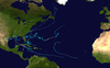
The 2002 Atlantic hurricane season was a near-average Atlantic hurricane season. It officially started on June 1, 2002, and ended on November 30, dates which conventionally limit the period of each year when most tropical cyclones develop in the Atlantic Ocean. The season produced fourteen tropical cyclones, of which twelve developed into named storms; four became hurricanes, and two attained major hurricane status. While the season's first cyclone did not develop until July 14, activity quickly picked up: eight storms developed in the month of September. It ended early however, with no tropical storms forming after October 6—a rare occurrence caused partly by El Niño conditions. The most intense hurricane of the season was Hurricane Isidore with a minimum central pressure of 934 mbar, although Hurricane Lili attained higher winds and peaked at Category 4 whereas Isidore only reached Category 3. However, Lili had a minimum central pressure of 938 mbar.

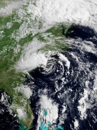
The 1962 Atlantic hurricane season was the least active since 1946, with only seven named storms. The season officially began on June 15, while the first tropical storm developed on June 30. No further activity occurred until late August, when Hurricane Alma brushed the Outer Banks before becoming extratropical southeast of New England, destroying hundreds of boats and producing beneficial rainfall. Around that time, Tropical Storm Becky developed unusually far east in the Atlantic Ocean, becoming the easternmost storm on record to recurve to the northeast. Celia followed in the September, forming east of the Lesser Antilles and executing a loop near Bermuda before dissipating. Hurricane Daisy was the costliest of the season, leaving about $1.1 million in damage in New England (1962 USD). The storm dropped the highest rainfall total on record in Maine, and its precipitation caused 22 traffic fatalities. Ella, the strongest storm of the season, remained offshore of the eastern United States but caused two deaths. The final system, an unnamed hurricane, formed on November 28 and meandered eratically off the Southeastern United States before becoming extratropical on December 4.

The 1990 Atlantic hurricane season was the most active Atlantic hurricane season since 1969, with a total of 14 named storms. The season also featured eight hurricanes, one of which intensified into a major hurricane. It officially began on June 1, 1990, and lasted until November 30, 1990. These dates conventionally delimit the period of each year when most tropical cyclones form in the Atlantic basin. However, tropical cyclogenesis can occur prior to the start of the season, as demonstrated with Tropical Depression One, which formed in the Caribbean Sea on May 24.

Hurricane Gloria was a powerful hurricane that caused significant damage along the east coast of the United States and in Atlantic Canada during the 1985 Atlantic hurricane season. It was the first significant tropical cyclone to strike the northeastern United States since Hurricane Agnes in 1972 and the first major storm to affect New York City and Long Island directly since Hurricane Donna in 1960. Gloria was a Cape Verde hurricane originating from a tropical wave on September 16 in the eastern Atlantic Ocean. After remaining a weak tropical cyclone for several days, Gloria intensified into a hurricane on September 22 north of the Lesser Antilles. During that time, the storm had moved generally westward, although it turned to the northwest due to a weakening of the ridge. Gloria quickly intensified on September 24, and the next day reached peak winds of 145 mph (233 km/h). The hurricane weakened before striking the Outer Banks of North Carolina on September 27. Later that day, Gloria made two subsequent landfalls on Long Island and across the coastline of western Connecticut, before becoming extratropical on September 28 over New England. The remnants moved through Atlantic Canada and went on to impact Western Europe, eventually dissipating on October 4.

The 1937 Atlantic hurricane season was a below-average hurricane season, featuring eleven tropical storms; of these, four became hurricanes. One hurricane reached major hurricane intensity, equivalent to a Category 3 or higher on the modern Saffir–Simpson scale. The United States Weather Bureau defined the season as officially lasting from June 16 to October 16. Tropical cyclones that did not approach populated areas or shipping lanes, especially if they were relatively weak and of short duration, may have remained undetected. Because technologies such as satellite monitoring were not available until the 1960s, historical data on tropical cyclones from this period are often not reliable. As a result of a reanalysis project which analyzed the season in 2012, a tropical storm and a hurricane were added to the Atlantic hurricane database (HURDAT). The official intensities and tracks of all storms were also revised by the reanalysis. The year's first storm formed on July 29 in the Gulf of Mexico, and the final system, a hurricane, dissipated over open ocean on October 21.

Hurricane Edouard was the strongest hurricane of the 1996 Atlantic hurricane season, reaching winds of 145 mph (233 km/h) on its path. Edouard remained a major hurricane for eight days, an unusually long amount of time. A Cape Verde hurricane, the storm formed near the coast of Africa in the middle of August. It moved westward then curved northward, and persisted until early September when it became extratropical to the southeast of New England. Edouard was originally forecast to strike the northeast United States, but it produced hurricane-force gusts to portions of southeastern Massachusetts while remaining offshore. The winds caused minor damage totaling $20 million. In addition, the hurricane generated strong waves and rip currents to coastlines, killing two people in Ocean City, New Jersey and causing numerous injuries.

The 1991 Perfect Storm, also known as The No-Name Storm and the Halloween Gale/Storm, was a damaging and deadly nor'easter in October 1991. Initially an extratropical cyclone, the storm absorbed Hurricane Grace to its south and evolved into a small unnamed hurricane later in its life. Damage from the storm totaled over $200 million and thirteen people were killed in total, six of which were an outcome of the sinking of Andrea Gail, which inspired the book and later movie, The Perfect Storm. The nor'easter received the name, playing off the common expression, after a conversation between Boston National Weather Service forecaster Robert Case and author Sebastian Junger.
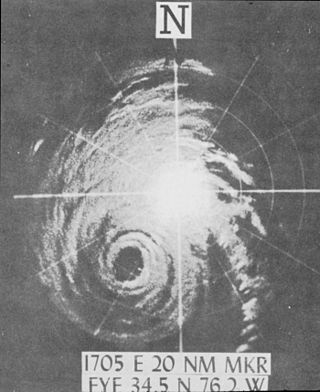
Hurricane Helene was the most intense tropical cyclone of the 1958 Atlantic hurricane season. The eighth tropical storm and fourth hurricane of the year, Helene was formed from a tropical wave east of the Lesser Antilles on September 21, 1958. Moving steadily westward, the storm slowly intensified, attaining hurricane strength on September 24. As conditions became increasingly favorable for tropical cyclone development, Helene began to rapidly intensify. Nearing the United States East Coast, the hurricane quickly attained Category 4 intensity on September 26, before it subsequently reached its peak intensity with maximum sustained winds of 150 mph (240 km/h) and a minimum barometric pressure of 930 mbar. The intense hurricane came within 10 mi (16 km) of Cape Fear, North Carolina before recurving out to sea. Accelerating northward, Helene gradually weakened, and transitioned into an extratropical cyclone as it passed over Newfoundland on September 29. Helene's extratropical remnants traversed eastwards across the Atlantic Ocean before dissipating near Great Britain on October 4.
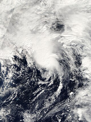
Subtropical Storm Nicole was the first subtropical storm to receive a name using the standard hurricane name list that did not become a tropical cyclone. The fifteenth tropical or subtropical cyclone and fourteenth named storm of the 2004 Atlantic hurricane season, Nicole developed on October 10 near Bermuda from a broad surface low that developed as a result of the interaction between an upper level trough and a decaying cold front. The storm turned to the northeast, passing close to Bermuda as it intensified to reach peak winds of 50 mph (80 km/h) on October 11. Deep convection developed near the center of the system as it attempted to become a fully tropical cyclone. However, it failed to do so and was absorbed by an extratropical cyclone late on October 11.

Hurricane Karen was a hurricane of non-tropical origin that formed in October of the 2001 Atlantic hurricane season. It developed out of the interaction between a cold front and an upper level trough on October 10 located to the south of Bermuda, and quickly strengthened as an extratropical storm. The storm passed near Bermuda on October 12, producing hurricane-force winds on the island. It then organized, becoming a subtropical cyclone on October 12 and a tropical cyclone on October 13. Karen strengthened to reach 80 mph (130 km/h) winds as a Category 1 hurricane on the Saffir-Simpson Hurricane Scale, and after weakening over cooler waters, it made landfall on Nova Scotia as a tropical storm. It quickly became extratropical.
Hurricane Bertha caused minor damage in the United States, Bermuda, and Atlantic Canada in July and August 1990. The third tropical cyclone, second named storm, and first hurricane of the 1990 Atlantic hurricane season, Bertha developed from a frontal low pressure area offshore of North Carolina on July 24. Initially subtropical, it slowly acquired tropical characteristics while tracked southeast and then southwestward. By early on July 27, the cyclone was re-classified as a tropical depression. Following its transition, the depression intensified and was upgraded to Tropical Storm Bertha on July 28. The storm then curved northeastward and rapidly strengthened. Bertha became a hurricane early on July 29, though it weakened back to a tropical storm later that day. On the following day, Bertha re-intensified into a hurricane and peaked as an 80 mph (130 km/h) Category 1 hurricane on July 31.
Tropical Storm Arthur was the first tropical cyclone and named storm of the annual Atlantic hurricane season that caused minimal flooding in the Carolinas in mid-June 1996. Arthur originated from an area of increased convection east of the Bahamas on June 16. Gradually, the system increased in organization, and was designated as a tropical depression on June 17. The depression tracked north-northwest and became Tropical Storm Arthur while just offshore the Southeastern United States on June 19. Later that day, Arthur peaked with maximum sustained winds of 45 mph (75 km/h), but weakened slightly before making landfall in North Carolina early the following day. After striking North Carolina, Arthur tracked out to sea and weakened further to a tropical depression. By June 21, Arthur transitioned into an extratropical cyclone. Overall, impact from Arthur was minimal, limited to light rainfall and moderate surf in North and South Carolina, as well as a tornado in Florida. Total damage amounted to $1 million (1996 USD), but no fatalities were reported.

The 2014 Atlantic hurricane season was an well below-average hurricane season in terms of named storms while the number of hurricanes and major hurricanes, were overall average. It produced nine tropical cyclones, eight of which became named storms; six storms became hurricanes and two intensified further into major hurricanes. The season officially began on June 1, and ended on November 30. These dates historically describe the period each year when most tropical cyclones form in the Atlantic basin. The first storm of the season, Arthur, developed on July 1, while the final storm, Hanna, dissipated on October 28, about a month prior to the end of the season.

Hurricane Alma impacted much of the East Coast of the United States in late August 1962. The second tropical storm of the season, Alma formed from a tropical wave located offshore South Florida on August 26. Initially a tropical depression, it subsequently moved inland over South Florida. Impact in the state was minor, generally limited to light rainfall and rough seas. Early on August 27, the depression reemerged into the Atlantic Ocean and strengthened into Tropical Storm Alma later that day. Thereafter, it moved northeastward and remained offshore the East Coast of the United States. Alma strengthened into a hurricane on August 28, while located offshore the Outer Banks of North Carolina. In the eastern portion of the state, strong winds downed electrical poles, which caused power outages. Storm tides caused erosion in some areas. Damage in North Carolina reached $35,000 (1962 USD).

The 2019 Atlantic hurricane season was the fourth consecutive above-average and damaging season dating back to 2016. The season featured eighteen named storms, however, many storms were weak and short-lived, especially towards the end of the season. Six of those named storms achieved hurricane status, while three intensified into major hurricanes. Two storms became Category 5 hurricanes, marking the fourth consecutive season with at least one Category 5 hurricane, the third consecutive season to feature at least one storm making landfall at Category 5 intensity, and the seventh on record to have multiple tropical cyclones reaching Category 5 strength. The season officially began on June 1 and ended on November 30. These dates historically describe the period each year when most tropical cyclones form in the Atlantic basin and are adopted by convention. However, tropical cyclogenesis is possible at any time of the year, as demonstrated by the formation of Subtropical Storm Andrea on May 20, making this the fifth consecutive year in which a tropical or subtropical cyclone developed outside of the official season.

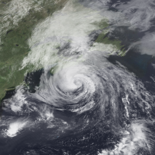
Hurricane Arthur was the earliest known hurricane to make landfall in the U.S. state of North Carolina during the calendar year. It was also the first hurricane to make landfall in the United States since Hurricane Isaac in 2012. The first named storm of the 2014 Atlantic hurricane season, Arthur developed from an initially non-tropical area of low-pressure over the Southeastern United States that emerged into the western Atlantic Ocean on June 28. After sufficiently organizing, developing a well-defined circulation and deep convection amid a favorable environment, it was classified as a tropical depression on July 1. The system continued to strengthen and was declared a tropical storm later that day. Drifting northward, the storm reached hurricane status early on July 3 and curved toward the north-northeast. Further structural organization resulted in additional intensification, and by 01:00 UTC on July 4, the system attained its peak winds of 100 mph (160 km/h) as a Category 2 hurricane on the Saffir–Simpson hurricane wind scale. Arthur made landfall at 03:15 UTC over North Carolina's Shackleford Banks, positioned between Cape Lookout and Beaufort, and intensified slightly further, with a minimum atmospheric pressure of 973 mbar. The storm then trekked swiftly northeast, weakening as it passed by Cape Cod and Nantucket, before transitioning into an extratropical cyclone and coming ashore at Weymouth, Nova Scotia, on July 5. The remnants continued generally northeastward through Atlantic Canada before ultimately dissipating on July 9 over the Labrador Sea.