Hurricane Bonnie (1992)

Last updated
Map key
  Tropical depression (≤38 mph, ≤62 km/h)
  Tropical storm (39–73 mph, 63–118 km/h)
  Category 1 (74–95 mph, 119–153 km/h)
  Category 2 (96–110 mph, 154–177 km/h)
  Category 3 (111–129 mph, 178–208 km/h)
  Category 4 (130–156 mph, 209–251 km/h)
  Category 5 (≥157 mph, ≥252 km/h)
  Unknown
Storm type
Disc Plain black.svg Tropical cyclone
Solid black.svg Subtropical cyclone
ArrowUp.svg Extratropical cyclone, remnant low, tropical disturbance, or monsoon depression

The origins of the system was a cold front that moved off the U.S. East Coast on September 11. The front moved gradually off the coast and into the subtropical Atlantic Ocean before becoming stationary just east of Bermuda on September 15. Over the next two days, the cloud cover slowly detached itself from the front and form into a tropical low in its own right. [2] On the afternoon of September 17, the system was organized enough to be declared Tropical Depression Four. [3]

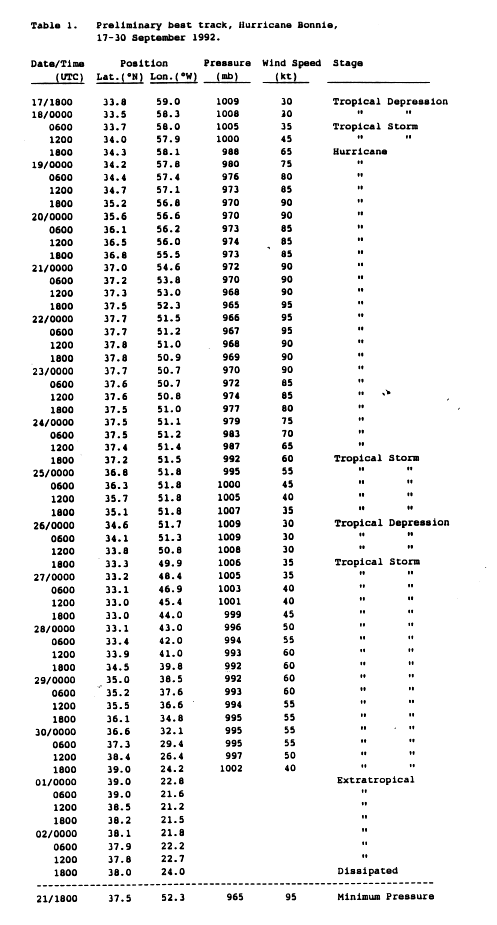
The depression organized steadily that evening and into the morning of September 18. Later that day, it was upgraded to Tropical Storm Bonnie and it began to move slowly to the northeast. [4] Like most storms that develop in higher latitudes, Bonnie was embedded in a larger-scale cyclonic circulation at first, which minimized shear (allowing it to develop) and provided weak steering currents. [2] The low shear allowed Bonnie to rapidly develop and a small but well-defined eye formed late that morning. [5] The storm was upgraded to a hurricane later that day while meandering in the open ocean. [2] The intensification rate slowed down after becoming a hurricane. In addition, Bonnie began to slowly move more to the northeast on September 19 as steering currents slowly developed. [6] Bonnie strengthened into a Category 2 hurricane on the Saffir-Simpson hurricane scale that morning as well, peaking at 105 mph (165 km/h) with a 970 mbar central pressure. [7] The general track and intensity maintained itself throughout the day and into September 20, when the eye became less distinct and Bonnie weakened slightly, although remaining a Category 2 hurricane. Early on September 21, the eye became better defined once again and Bonnie restrengthened slightly while continuing its slow northeast motion. [2] That afternoon, the storm gradually strengthened some more and reached its peak intensity of 110 mph (175 km/h) and a central pressure of 965 mbar, just under Category 3 intensity. Bonnie maintained its strength through the evening and into the early morning of September 22, when it began to weaken very gradually and level off. [7] Bonnie also began to turn more eastward at that point before it became held up by a blocking mid-latitude ridge of high pressure, which stalled the motion. [8]

Bonnie remained virtually stationary until the morning of September 23 when it drifted very slowly to the west-southwest in response to the ridge. It also began to gradually weaken as the low-level center became exposed and the storm became poorly organized. [2] Convection also diminished, and on the afternoon of September 24, Bonnie was downgraded to a tropical storm as it drifted over cooler waters. [9] Bonnie continued to lose most of its deep convection during the day on September 25 as it began to make a turn back around to the south. That evening, Bonnie was downgraded to a tropical depression. [2]

Close-up of Bonnie's eye on September 19, as seen from Space Shuttle Endeavour Hurricane Bonnie STS-47 1992-09-19 1101z (3).jpg
Close-up of Bonnie's eye on September 19, as seen from Space Shuttle Endeavour

The weakening trend ended early on September 26 and Bonnie regained tropical storm status that afternoon as deep convection re-established itself. [10] Bonnie continued its change in direction, turning to the southeast at this point as it slowly redeveloped despite being in a high-shear environment. [11] It had also briefly showed signs of becoming extratropical on September 27 as it made the turn to the northeast as a weak tropical storm, and was operationally declared extratropical at that point until the afternoon of September 28. [12] During that period, Bonnie actually strengthened back into a high-end tropical storm. [7] Bonnie roughly followed Hurricane Charley's path towards the Azores thereafter. The storm became entrenched in an environment with greater wind shear, [13] although it only weakened slightly on September 29 as it accelerated towards the northeast. [7] The storm crossed over the Azores on September 30 as a strong tropical storm with 65 mph (100 km/h) winds. After that, Bonnie quickly lost its tropical characteristics and was declared extratropical late that afternoon, just east of the Azores. [2] The extratropical low drifted back to the southwest in a clockwise loop, actually approaching the Azores once again while dissipating. It dissipated on October 2. [14]

Impact

When Bonnie passed over the Azores only four days after Charley, it resulted in tropical storm-force winds across much of the island chain. Lajes Air Base reported sustained winds of 40 mph (64 km/h) with gusts to 59 mph (94 km/h). [14] In addition, one man was killed by a rock fall on the island of São Miguel. [15] No damage was reported in the Azores. [14]

See also

Related Research Articles

<span class="mw-page-title-main">Hurricane Alberto (2000)</span> Category 3 Atlantic hurricane in 2000

Hurricane Alberto was the farthest-travelling tropical cyclone on record in the Atlantic Ocean. The third tropical cyclone, first named storm, and first hurricane of the 2000 Atlantic hurricane season, Alberto developed near the western coast of Africa from a tropical wave on August 3. Initially a tropical depression, it strengthened into Tropical Storm Alberto early on August 4. While briefly turning westward on August 6, Alberto attained hurricane status. The cyclone continued to track west-northwestward, and by early the following day, reached an initial peak with winds of 90 mph (140 km/h). Shortly thereafter, Alberto re-curved northwestward and began encountering increased wind shear. As a result, Alberto weakened back to a tropical storm on August 9. However, the system quickly re-strengthened as winds became more favorable, and early on August 10, Alberto became a hurricane again. The storm gradually curved northward and north-northeastward between August 11 and August 12; Alberto attained its peak intensity with winds of 125 mph (201 km/h) during that time.

<span class="mw-page-title-main">Hurricane Danielle (1998)</span> Category 2 Atlantic hurricane in 1998

Hurricane Danielle was a long-lived Cape Verde hurricane in late August and early September 1998. The fourth named storm and second hurricane of the annual hurricane season, Danielle originated from a tropical wave that emerged off the western coast of Africa on August 21. Tracking generally west-northwestward, the disturbance was initially disorganized; under favorable atmospheric conditions, shower and thunderstorm activity began to consolidate around a low-pressure center. Following a series of satellite intensity estimates, the system was upgraded to Tropical Depression Four during the pre-dawn hours of August 24, and further to Tropical Storm Danielle that afternoon. Moving around the southern periphery of the Azores High located in the northeastern Atlantic, quick intensification to hurricane status occurred early on August 25. By 0600 UTC the following day, Danielle reached an initial peak intensity of 105 mph (169 km/h), a Category 2 hurricane. Increased wind shear from a nearby trough encroached on further development later that day, and subsequently led to slight weakening. By 1200 UTC on August 27, despite continued unfavorable conditions, Danielle reached a second peak intensity equal to the first. Weakening once ensued late on August 27 in addition to the days following, and Danielle was a low-end Category 1 hurricane by August 31 as its forward speed slowed.

<span class="mw-page-title-main">1998 Atlantic hurricane season</span> Hurricane season in the Atlantic Ocean

The 1998 Atlantic hurricane season was an above average and catastrophic Atlantic hurricane season, featuring the highest number of storm-related fatalities in over 218 years and one of the costliest ever at the time. The season had above average activity, due to the dissipation of the El Niño event and transition to La Niña conditions. It officially began on June 1 and ended on November 30, dates which conventionally delimit the period during which most tropical cyclones form in the Atlantic Ocean. The season had a rather slow start, with no tropical cyclones forming in June. The first tropical cyclone, Tropical Storm Alex, developed on July 27, and the season's final storm, Hurricane Nicole, became extratropical on December 1.

<span class="mw-page-title-main">1992 Atlantic hurricane season</span> Hurricane season in the Atlantic Ocean

The 1992 Atlantic hurricane season was a significantly below average season in which only ten tropical or subtropical cyclones formed. Six became named tropical storms, of which four became hurricanes. Among the four was Hurricane Andrew, a major hurricane, and the costliest Atlantic hurricane on record at the time, surpassing Hugo of 1989. The season officially started on June 1 and officially ended on November 30. However, tropical cyclogenesis is possible at any time of the year, as demonstrated by formation in April of an unnamed subtropical storm in the central Atlantic. A June tropical depression caused flooding in Cuba and in Florida, where two people were killed. In August, Andrew struck the Bahamas, Florida, and Louisiana. In all, it caused $27.3 billion in damage, mostly in Florida, as well as 65 fatalities. The greatest impact was in South Florida, where the storm made landfall with 1-minute sustained winds of 175 mph (280 km/h).

<span class="mw-page-title-main">1991 Atlantic hurricane season</span> Hurricane season in the Atlantic Ocean

The 1991 Atlantic hurricane season was the first season since 1984 in which no hurricanes developed from tropical waves, which are the source for most North Atlantic tropical cyclones. The hurricane season officially began on June 1, and ended on November 30. It was the least active in four years due to higher than usual wind shear across the Atlantic Ocean. The first storm, Ana, developed on July 2 off the southeast United States and dissipated without causing significant effects. Two other tropical storms in the season – Danny and Erika – did not significantly affect land. Danny dissipated east of the Lesser Antilles, and Erika passed through the Azores before becoming extratropical. In addition, there were four non-developing tropical depressions. The second depression of the season struck Mexico with significant accompanying rains.

<span class="mw-page-title-main">2007 Atlantic hurricane season</span> Hurricane season in the Atlantic Ocean

The 2007 Atlantic hurricane season was the first season since 2003 to feature tropical activity both before and after the official bounds of the season. There were an above-average number of named storms during the season – 15, however many storms were weak and short-lived. Despite the predominance of weak systems, this was the first season on record to feature more than one Category 5 landfalling hurricane. This would not happen again until 2017. It produced 17 tropical cyclones, 15 tropical storms, six hurricanes, and two major hurricanes. It officially started on June 1 and ended on November 30, dates which conventionally delimit the period during which most tropical cyclones form in the Atlantic Ocean, although as shown by Subtropical Storm Andrea and Tropical Storm Olga in early May and early December, respectively, the formation of tropical cyclones is possible at any time of the year. The first system, Subtropical Storm Andrea, developed on May 9, while the last storm, Tropical Storm Olga, dissipated on December 13. The most intense hurricane, Dean, was, at the time, the third most intense landfalling Atlantic storm on record. It was the second on record in which an Atlantic hurricane, Felix, and an eastern Pacific hurricane, Henriette, made landfall on the same day. September had a then record-tying eight storms, until it was surpassed in 2020. However, the strengths and durations of most of the storms were low.

<span class="mw-page-title-main">Hurricane Gert (1999)</span> Category 4 Atlantic hurricane in 1999

Hurricane Gert was the fourth of five major hurricanes in the moderately active 1999 Atlantic hurricane season. A Cape Verde hurricane, Gert formed on September 11 off the coast of Africa before heading west-northwest. It reached a peak wind speed of 150 mph (240 km/h) by September 15 over the open central Atlantic east-northeast of the Leeward Islands. It gradually curved to the northwest and later to the north, due to a weakness in the subtropical ridge created by Hurricane Floyd. Hurricane Gert passed east of Bermuda on September 21 and began a steady weakening trend at that time. It turned to the northeast, and on September 23, Gert transitioned into an extratropical cyclone to the southeast of Atlantic Canada before being absorbed by a larger storm.

<span class="mw-page-title-main">Hurricane Kate (2003)</span> Category 3 Atlantic hurricane in 2003

Hurricane Kate was a long-lived and erratic tropical cyclone that caused minor impacts across the Atlantic Ocean from late September to early October 2003. The sixteenth tropical cyclone, eleventh tropical storm, seventh hurricane, and third major hurricane of the 2003 Atlantic hurricane season, Kate developed from a tropical wave in the central tropical Atlantic on September 25. Its unusual track included four major changes in direction. The storm moved northwestward until a weakness in the subtropical ridge forced it eastward. Kate strengthened to a hurricane, turned sharply westward while moving around a mid-level low, and intensified to a 125 mph (201 km/h) major hurricane on October 4. Kate turned sharply northward around the periphery of an anticyclone, weakened, and became extratropical after passing to the east of Newfoundland. The extratropical storm persisted for three days until losing its identity near Scandinavia.

<span class="mw-page-title-main">Hurricane Iris (1995)</span> Category 2 Atlantic hurricane in 1995

Hurricane Iris was the first of three tropical cyclones to affect the Lesser Antilles in a three-week period, preceding the more destructive hurricanes Luis and Marilyn. The ninth named storm and fifth hurricane of the 1995 Atlantic hurricane season, Iris developed from a tropical wave to the east of the Lesser Antilles on August 22 and attained hurricane status within 30 hours. The hurricane weakened to a tropical storm before crossing the islands of the eastern Caribbean from August 26 through August 28. During that time, Iris became one of four active tropical storms in the Atlantic basin. Earlier it had interacted with Hurricane Humberto, and beginning on August 30, Iris interacted with Tropical Storm Karen. Iris re-intensified into a hurricane and attained peak sustained winds of 110 mph (175 km/h) while moving slowly across the central Atlantic. The hurricane accelerated to the north and absorbed a dissipating Karen on September 3. Iris weakened to a tropical storm and became extratropical on September 4, though its remnants re-attained hurricane-force winds, before affecting western Europe on September 7. The storm dissipated soon afterward.

<span class="mw-page-title-main">Hurricane Gordon (2006)</span> Category 3 Atlantic hurricane

Hurricane Gordon was the first tropical cyclone since 1992 to affect the Azores while retaining tropical characteristics. The eighth tropical storm, third hurricane, and first major hurricane of the 2006 Atlantic hurricane season, Gordon formed on September 10 in the tropical Atlantic Ocean. It gradually matured into a hurricane as it tracked northward, reaching its peak intensity with winds of 195 km/h (121 mph) early on September 14 while located about 925 km (575 mi) southeast of Bermuda. After becoming nearly stationary, Gordon weakened to minimal hurricane status, although it re-intensified after accelerating to the east. It weakened again after moving over cooler waters, and passed through the Azores on September 20. Shortly thereafter, it became an extratropical cyclone and subsequently affected Spain, Ireland, and the United Kingdom.

<span class="mw-page-title-main">Hurricane Tanya</span> Category 1 Atlantic hurricane in 1995

Hurricane Tanya was the first named storm to start with a "T" in the Atlantic since naming began in 1950, and the final storm of the very active 1995 Atlantic hurricane season. The twenty-first tropical cyclone, nineteenth named storm, and eleventh hurricane of the season, Tanya developed from a tropical wave while well north of the Lesser Antilles on October 26. The system headed northeastward and strengthened into Tropical Storm Tanya on October 27. Tanya meandered around the central Atlantic, and further intensified into a hurricane on October 29. Thereafter, Tanya tracked northeastward before curving to the east-northeast. After switching to an eastward direction, Tanya weakened to a tropical storm on November 1. Later that day, Tanya passed through the Azores as it was transitioning into an extratropical cyclone.

<span class="mw-page-title-main">Hurricane Isaac (2000)</span> Category 4 Atlantic hurricane in 2000

Hurricane Isaac was a large and powerful Cape Verde hurricane that lasted through late September and early October 2000. The thirteenth tropical cyclone, ninth named storm, and the fifth hurricane of 2000 Atlantic hurricane season, Isaac developed from a tropical wave south of Cape Verde on September 21. The depression intensified, and on the following day, it was upgraded to Tropical Storm Isaac. Due to conductive atmospheric conditions, Isaac continued to strengthen, and attained hurricane intensity on September 23. Isaac managed to become a Category 3 hurricane on September 24, before steadily weakening shortly thereafter. By September 26, the storm had deteriorated to a Category 1 hurricane. However, it again encountered favorable conditions, which caused Isaac to re-intensify.

<span class="mw-page-title-main">Timeline of the 1992 Atlantic hurricane season</span>

The 1992 Atlantic hurricane season was among the least active of any Atlantic hurricane season on record. It produced six named tropical cyclones. The season officially started on June 1, 1992, and ended on November 30. These dates, adopted by convention, historically delimit the period each year when most Atlantic tropical systems form. However, storm formation is possible at any time of the year, as was the case this season, when Subtropical Storm One formed on April 21. This timeline documents all the storm formations, strengthening, weakening, landfalls, extratropical transitions, as well as dissipations during the season.

<span class="mw-page-title-main">Timeline of the 1998 Atlantic hurricane season</span>

The 1998 Atlantic hurricane season was an event in the annual tropical cyclone season in the north Atlantic Ocean. This Atlantic hurricane season saw an above-average number of named tropical storms, and included a single-day record for number of hurricanes simultaneously in progress, with four active on September 25: Georges, Ivan, Jeanne and Karl. The season officially began on June 1, 1998 and ended on November 30, 1998. These dates, adopted by convention, historically describe the period in each year when most tropical systems form. Even so, this season's first storm, Tropical Storm Alex, did not form until July 27, while its last, Hurricane Nicole, dissipated on December 1.

<span class="mw-page-title-main">Tropical Storm Zeke (1992)</span> Pacific tropical storm in 1992

Tropical Storm Zeke was the final named storm of the record-breaking 1992 Pacific hurricane season. Forming out of a tropical wave on October 25, Zeke began as a disorganized depression. Tracking west-northwestward, the system gradually developed organized convection and intensified into a tropical storm. However, it soon entered a high wind shear environment, causing Zeke to weaken to a tropical depression. The following day, the storm re-intensified despite unfavorable conditions and later attained peak winds of 50 mph (80 km/h) on October 29. Rapid weakening followed shortly thereafter as convection dissipated and the center became exposed. During the afternoon of October 30, Zeke degenerated into a remnant low pressure system and dissipated several days later several hundred miles south of Baja California Sur.

<span class="mw-page-title-main">Hurricane Epsilon (2005)</span> Category 1 Atlantic hurricane in 2005

Hurricane Epsilon was the twenty-seventh named tropical or subtropical storm and the final of 15 hurricanes in the record-breaking 2005 Atlantic hurricane season. Originating from a cold front beneath an upper-level low, Epsilon formed on November 29 about 915 mi (1470 km) east of Bermuda, becoming the second tropical storm to do so in that area of the Atlantic within the span of a week. Initially, the National Hurricane Center (NHC) forecast the storm to transition into an extratropical cyclone within five days, due to conditions unfavorable for significant intensification. Epsilon continually defied forecasts, at first due to an unexpected loop to the southwest, and later due to retaining its strength despite cold waters and strong wind shear.

<span class="mw-page-title-main">Tropical Storm Beryl (2012)</span> Atlantic tropical storm in 2012

Tropical Storm Beryl was the strongest off-season Atlantic tropical cyclone on record to make landfall in the United States. The second tropical cyclone of the 2012 Atlantic hurricane season, Beryl developed on May 26 from a low-pressure system offshore North Carolina. Initially subtropical, the storm slowly acquired tropical characteristics as it tracked across warmer sea surface temperatures and within an environment of decreasing vertical wind shear. Late on May 27, Beryl transitioned into a tropical cyclone less than 120 miles (190 km) from North Florida. Early the following day, the storm moved ashore near Jacksonville Beach, Florida, with peak winds of 65 mph (100 km/h). It quickly weakened to a tropical depression, dropping heavy rainfall while moving slowly across the southeastern United States. A cold front turned Beryl to the northeast, and the storm became extratropical on May 30.

<span class="mw-page-title-main">Hurricane Nadine</span> Category 1 Atlantic hurricane in 2012

Hurricane Nadine was an erratic Category 1 hurricane that became the fourth-longest-lived Atlantic hurricane on record. As the fourteenth tropical cyclone and named storm of the 2012 Atlantic hurricane season, Nadine developed from a tropical wave traveling west of Cape Verde on September 10. On the following day, it had strengthened into Tropical Storm Nadine. After initially tracking northwestward, Nadine turned northward, well away from any landmass. Early on September 15, Nadine reached hurricane status as it was curving eastward. Soon after, an increase in vertical wind shear weakened Nadine and by September 16 it was back to a tropical storm. On the following day, the storm began moving northeastward and threatened the Azores but late on September 19, Nadine veered east-southeastward before reaching the islands. Nonetheless, the storm produced tropical storm force winds on a few islands. On September 21, the storm curved south-southeastward while south of the Azores. Later that day, Nadine transitioned into a extratropical low pressure area.

<span class="mw-page-title-main">Meteorological history of Hurricane Mitch</span>

Hurricane Mitch's meteorological history began with its origins over Africa as a tropical wave and lasted until its dissipation as an extratropical cyclone north of the United Kingdom. Tropical Depression Thirteen formed on October 22, 1998, over the southwestern Caribbean Sea from a tropical wave that exited Africa on October 10. It executed a small loop, and while doing so intensified into Tropical Storm Mitch. A weakness in a ridge allowed the storm to track slowly to the north. After becoming disorganized due to wind shear from a nearby upper-level low, Mitch quickly intensified in response to improving conditions which included warm waters and good outflow. It became a hurricane on October 24 and developed an eye. After turning to the west, Mitch rapidly intensified, first into a major hurricane on October 25 and then into a Category 5 on the Saffir-Simpson Hurricane Scale the next day.

References

  1. Unisys Weather (1992). "Unisys Weather: 1992 Hurricane/Tropical Data for Atlantic". Unisys. Archived from the original on 2016-04-09. Retrieved 2006-12-12.
  2. 1 2 3 4 5 6 7 Richard J. Pasch (December 1, 1992). Preliminary Report: Hurricane Bonnie 17-30 September 1992 (Report). National Hurricane Center. p. 1. Retrieved 2013-02-25.
  3. Lixion A. Avila (September 17, 1992). Tropical Depression Four Discussion Number 1 (TXT) (Report). National Hurricane Center. Retrieved 2013-02-25.
  4. Edward N. Rappaport (September 18, 1992). Tropical Storm Bonnie Discussion Number 4 (TXT) (Report). National Hurricane Center. Retrieved 2013-02-25.
  5. Jerry D. Jarrell (September 18, 1992). Hurricane Bonnie Discussion Number 5 (TXT) (Report). National Hurricane Center. Retrieved 2013-02-25.
  6. Miles B. Lawrence (September 19, 1992). Hurricane Bonnie Discussion Number 8 (TXT) (Report). National Hurricane Center. Retrieved 2013-02-25.
  7. 1 2 3 4 Richard J. Pasch (December 1, 1992). Preliminary best track, Hurricane Bonnie, 17-30 September 1992 (Report). p. 4. Retrieved 2013-02-25.
  8. Harold B. Gerrish (September 22, 1992). Hurricane Bonnie Discussion Number 18 (TXT) (Report). National Hurricane Center. Retrieved 2013-02-25.
  9. Lixion A. Avila (September 24, 1992). Tropical Storm Bonnie Discussion Number 28 (TXT) (Report). National Hurricane Center. Retrieved 2013-02-25.
  10. Jerry D. Jarrell (September 26, 1992). Tropical Storm Bonnie Discussion Number 36 (TXT) (Report). National Hurricane Center. Retrieved 2013-02-25.
  11. Richard J. Pasch (September 27, 1992). Tropical Storm Bonnie Discussion Number 38 (TXT) (Report). National Hurricane Center. Retrieved 2013-02-25.
  12. Harold B. Gerrish (September 28, 1992). Tropical Storm Bonnie Discussion Number 40 (TXT) (Report). National Hurricane Center. Retrieved 2013-02-25.
  13. Harold B. Gerrish (September 29, 1992). Tropical Storm Bonnie Discussion Number 45 (TXT) (Report). National Hurricane Center. Retrieved 2013-02-25.
  14. 1 2 3 Richard J. Pasch (December 1, 1992). Preliminary Report: Hurricane Bonnie 17-30 September 1992 (Report). National Hurricane Center. p. 2. Retrieved 2013-02-25.
  15. B. Max Mayfield; Lixion A. Avila; Edward N. Rappaport (March 1994). Atlantic Hurricane Season of 1992 (PDF) (Report). National Hurricane Center. Retrieved 2013-02-25.
Hurricane Bonnie
Bonnie 1992-09-21 1830Z.png
Bonnie at peak intensity southeast of Nova Scotia on September 21