
Hurricane Gloria was a powerful hurricane that caused significant damage along the east coast of the United States and in Atlantic Canada during the 1985 Atlantic hurricane season. It was the first significant tropical cyclone to strike the northeastern United States since Hurricane Agnes in 1972 and the first major storm to affect New York City and Long Island directly since Hurricane Donna in 1960. Gloria was a Cape Verde hurricane originating from a tropical wave on September 16 in the eastern Atlantic Ocean. After remaining a weak tropical cyclone for several days, Gloria intensified into a hurricane on September 22 north of the Lesser Antilles. During that time, the storm had moved generally westward, although it turned to the northwest due to a weakening of the ridge. Gloria quickly intensified on September 24, and the next day reached peak winds of 145 mph (233 km/h). The hurricane weakened before striking the Outer Banks of North Carolina on September 27. Later that day, Gloria made two subsequent landfalls on Long Island and across the coastline of western Connecticut, before becoming extratropical on September 28 over New England. The remnants moved through Atlantic Canada and went on to impact Western Europe, eventually dissipating on October 4.

Hurricane Irene produced somewhat heavy damage across southern Florida in October 1999. The ninth named storm and the sixth hurricane of the season, Irene developed in the western Caribbean Sea on October 13 from a tropical wave. It moved northward, hitting western Cuba before attaining hurricane status. Irene struck Florida on October 15 as a Category 1 on the Saffir–Simpson Hurricane Scale, first at Key West and later near Cape Sable. The storm moved across the state and tracked northward over the Gulf Stream. It approached the Carolinas but remained offshore. Irene turned eastward and significantly intensified into a strong Category 2 hurricane on October 18. By the following day, the system became extratropical due to cooler waters to the southeast of Newfoundland and was quickly absorbed by another extratropical low.

Hurricane Esther was the first large tropical cyclone to be discovered by satellite imagery. The fifth tropical cyclone, named storm, and hurricane of the 1961 Atlantic hurricane season, Esther developed from an area of disturbed weather hundreds of miles west-southwest of the southernmost Cape Verde Islands on September 10. Moving northwestward, the depression strengthened into Tropical Storm Esther on September 11, before reaching hurricane intensity on the following day. Early on September 13, Esther curved westward and deepened into a major hurricane. The storm remained a Category 3 hurricane for about four days and gradually moved in a west-northwestward direction. Late on September 17, Esther strengthened into a Category 5 hurricane with sustained winds of 160 mph (260 km/h) on September 18. The storm curved north-northeastward on September 19, while offshore of North Carolina. Esther began to weaken while approaching New England and fell to Category 3 intensity on September 21. The storm turned eastward early on the following day, and rapidly weakened to a tropical storm.

Hurricane Charley was the second hurricane to threaten the East Coast of the United States within a year's timeframe, after Hurricane Gloria of 1985. The third tropical storm and second hurricane of the season, Charley formed as a subtropical low on August 13 along the Florida panhandle. After moving off the coast of South Carolina, the system transitioned into a tropical cyclone and intensified into a tropical storm on August 15. Charley later attained hurricane status before moving across eastern North Carolina. It gradually weakened over the north Atlantic Ocean before transitioning into an extratropical cyclone on August 20. Charley's remnants remained identifiable for over a week, until after crossing Ireland and Great Britain they dissipated on August 30.

Hurricane Gladys was the first Atlantic hurricane to be observed each by the hurricane hunters, radar imagery, and photographs from space. The seventh named storm and fifth hurricane of the 1968 season, Gladys formed on October 13 in the western Caribbean from a broad disturbance related to a tropical wave. The storm moved north-northwestward, becoming a hurricane before striking Cuba on October 16. Gladys later reached peak winds of 100 mph (160 km/h) just before making landfall near Homosassa on the western coast of Florida on October 19. The hurricane crossed the state and continued northeastward, passing just east of Cape Hatteras on October 20. The next day, Gladys became extratropical and was absorbed by a cold front over Nova Scotia.

Hurricane Edouard was the strongest hurricane of the 1996 Atlantic hurricane season, reaching winds of 145 mph (233 km/h) on its path. Edouard remained a major hurricane for eight days, an unusually long amount of time. A Cape Verde hurricane, the storm formed near the coast of Africa in the middle of August. It moved westward then curved northward, and persisted until early September when it became extratropical to the southeast of New England. Edouard was originally forecast to strike the northeast United States, but it produced hurricane-force gusts to portions of southeastern Massachusetts while remaining offshore. The winds caused minor damage totaling $20 million. In addition, the hurricane generated strong waves and rip currents to coastlines, killing two people in Ocean City, New Jersey and causing numerous injuries.

Hurricane Felix caused severe beach erosion along the East Coast of the United States in August 1995. The seventh tropical cyclone, sixth named storm, and third hurricane of the 1995 Atlantic hurricane season, Felix was also the strongest hurricane in the Atlantic Ocean since Category 5 Hurricane Andrew in 1992. It developed from a tropical wave in the eastern Atlantic Ocean on August 8, and slowly intensified, reaching hurricane status on August 11. Under favorable conditions, Felix began to rapidly deepen while curving northwestward. Late on August 12, Felix peaked as a low-end Category 4 hurricane. However, it soon weakened rapidly to a Category 1 hurricane. Less than three days later, Felix passed only 75 mi (120 km) southeast of Bermuda. Although it also posed a threat to the East Coast of the United States, Felix curved northward and then east-northeastward while remaining offshore, thereby avoiding landfall. Felix briefly threatened Bermuda again, but weakened to a tropical storm and turned back to the northeast on August 20. It accelerated east-northeastward, and passed a short distance offshore of Newfoundland, where Felix transitioned into an extratropical storm on August 22.

Tropical Storm Alberto was the first tropical storm of the 2006 Atlantic hurricane season. Forming on June 10 in the northwestern Caribbean, the storm moved generally to the north, reaching a maximum intensity of 70 mph (110 km/h) before weakening and moving ashore in the Big Bend area of Florida on June 13. Alberto then moved through eastern Georgia, North Carolina, and Virginia as a tropical depression before becoming extratropical on June 14.

The 1933 Chesapeake–Potomac hurricane was among the most damaging hurricanes in the Mid-Atlantic states in the eastern United States. The sixth storm and third hurricane of the very active 1933 Atlantic hurricane season, it formed in the eastern Atlantic, where it moved west-northwestward and eventually became a Category 4 on the Saffir-Simpson hurricane wind scale. A strong ridge over New England allowed a continued northwest course, bringing the storm south of Bermuda and later toward the middle coast of the eastern United States. Advanced warning allowed hundreds of people to evacuate ahead of the hurricane making landfall. It did so in northeastern North Carolina on August 23 with winds of about 90 mph (140 km/h). Soon after, the eye crossed over Norfolk, Virginia, the first time that happened since 1821. The hurricane weakened into a tropical storm over northern Virginia shortly before passing near Washington, D.C., becoming the worst tropical cyclone there since 1896. Curving northward, the storm moved through Pennsylvania and New York before losing tropical characteristics on August 25. Now extratropical, the former hurricane moved across Atlantic Canada, dissipating on August 28.

Tropical Storm Chris caused minor flooding in the Greater Antilles and the Eastern United States in August 1988. The seventh tropical cyclone and third named storm of the annual hurricane season, Chris developed from a tropical wave while roughly midway between Africa and the Lesser Antilles on August 21. Forming as a tropical depression, it remained weak for several days, crossing the Lesser Antilles, Hispaniola, and The Bahamas during this time. While offshore the coast of Florida on August 28, the depression intensified into Tropical Storm Chris. Thereafter, the system tracked rapidly north-northwestward and came ashore near Savannah, Georgia later that day. Once inland, Chris quickly weakened, and by early on the following day, it weakened to a tropical depression over South Carolina. Six hours later, Chris was absorbed by a cold front while over North Carolina, though the remnants of the system tracked across the Eastern United States and Atlantic Canada before dissipating on August 30.

Tropical Storm Doria was the costliest tropical cyclone in the 1971 Atlantic hurricane season. The fifth tropical storm of the season, Doria developed from a tropical wave on August 20 to the east of the Lesser Antilles, and after five days without development it attained tropical storm status to the east of Florida. Doria turned to the north, and reached peak winds of 65 mph (105 km/h) as it was making landfall near Morehead City, North Carolina. It turned to the northeast, and moved through the Mid-Atlantic and New England as a tropical storm before becoming an extratropical storm over Maine on August 29.

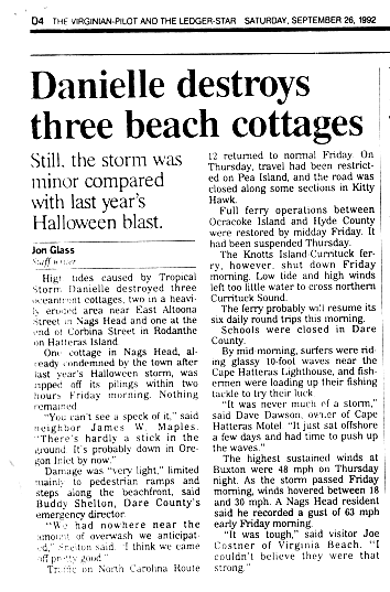
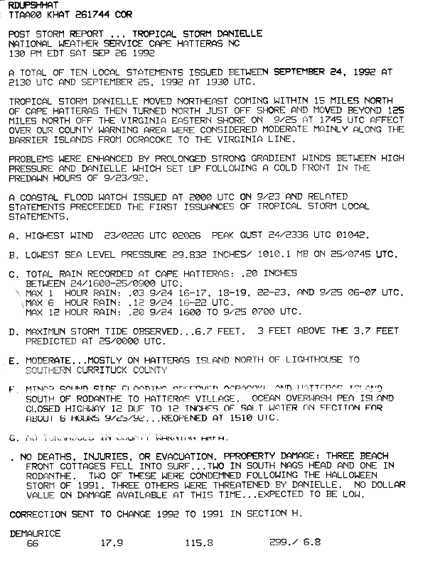
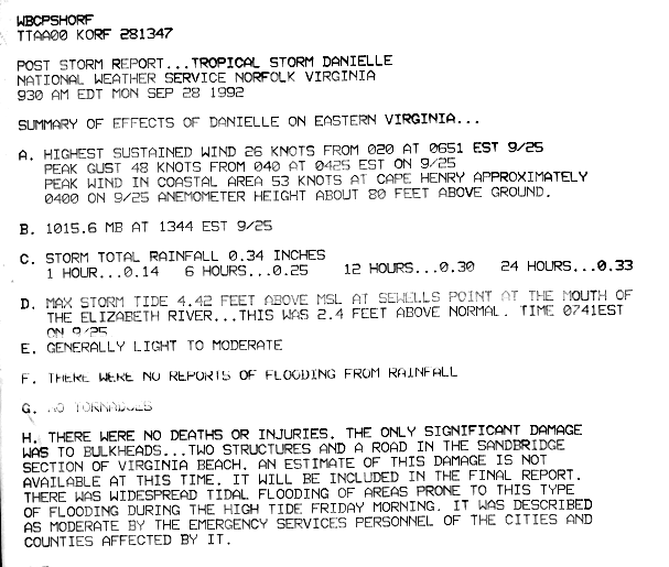
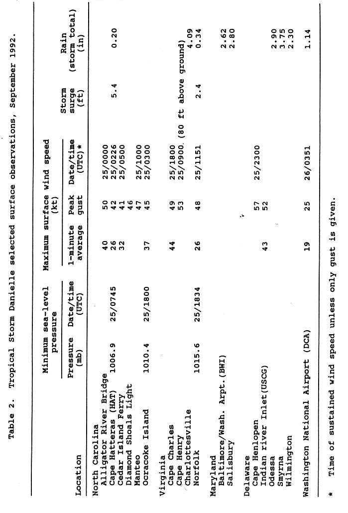
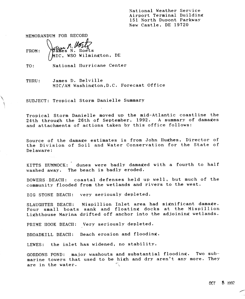
The effects of Hurricane Isabel in North Carolina were widespread, with the heaviest damage in Dare County. The hurricane made landfall in the Outer Banks of North Carolina on September 18. There, storm surge flooding and strong winds damaged thousands of houses. The storm surge produced a 2,000 feet (610 m) wide inlet on Hatteras Island, isolating Hatteras by road for two months. Several locations along North Carolina Highway 12 were partially washed out or covered with debris. Hurricane Isabel produced hurricane-force wind gusts across eastern North Carolina, knocking down trees and power lines. About 700,000 residents lost power due to the storm, although most outages were restored within a few days. The hurricane killed three people in the state – two due to falling trees, and the other a utility worker attempting to restore electricity. Damage in the state totaled $450 million.

Hurricane Bob was one of the costliest hurricanes in New England history. The second named storm and first hurricane of the 1991 Atlantic hurricane season, Bob developed from an area of low pressure near The Bahamas on August 16. The depression steadily intensified, and became Tropical Storm Bob late on August 16. Bob curved north-northwestward as a tropical storm, but re-curved to the north-northeast after becoming a hurricane on August 17. As such, it brushed the Outer Banks of North Carolina on August 18 and August 19, and subsequently intensified into a major hurricane. After peaking in intensity with maximum sustained winds of 115 mph (185 km/h), Bob weakened slightly as it approached the coast of New England.

Subtropical Storm Alpha was an off-season subtropical cyclone that impacted Georgia in May 1972. It developed from a previously non-tropical cyclone in the western Atlantic Ocean, and initially it moved northeastward off the Carolinas. The storm turned southwestward due to a building ridge, and concurrently it intensified to become Subtropical Storm Alpha. It later moved ashore near Savannah, and it finally dissipated in the northeast Gulf of Mexico on May 29. It produced wave action and moderate rainfall along the coast. Damage totaled over $100,000 (1972 USD), and there were two associated deaths.

Tropical Storm Bret was a strong tropical storm that made a rare landfall on the Delmarva Peninsula in June 1981. The sixth tropical cyclone, third designated tropical depression, and second named storm of the season, Bret developed as a subtropical storm from a large area of frontal clouds near Bermuda on June 29. Moving westward, the subtropical storm intensified while producing deep convection, and was consequently reclassified as a tropical storm early on June 30. Around that time, Bret peaked with sustained winds of 70 mph (110 km/h). The storm then began weakening and struck near Oyster, Virginia as a minimal tropical storm early on July 1. Upon moving inland, Bret weakened to a tropical depression and subsequently accelerated prior to dissipating over northern Virginia that same day.

Hurricane Alma impacted much of the East Coast of the United States in late August 1962. The second tropical storm of the season, Alma formed from a tropical wave located offshore South Florida on August 26. Initially a tropical depression, it subsequently moved inland over South Florida. Impact in the state was minor, generally limited to light rainfall and rough seas. Early on August 27, the depression reemerged into the Atlantic Ocean and strengthened into Tropical Storm Alma later that day. Thereafter, it moved northeastward and remained offshore the East Coast of the United States. Alma strengthened into a hurricane on August 28, while located offshore the Outer Banks of North Carolina. In the eastern portion of the state, strong winds downed electrical poles, which caused power outages. Storm tides caused erosion in some areas. Damage in North Carolina reached $35,000 (1962 USD).

Tropical Storm Fay was the first tropical cyclone to make landfall in the U.S state of New Jersey since Hurricane Irene in 2011. The sixth named storm of the very active 2020 Atlantic hurricane season, Fay was the earliest sixth named storm on record in the basin when it formed on July 9. Fay originated from a surface low that formed over the Northern Gulf of Mexico on July 3 and slowly drifted eastward, before crossing over the Florida Panhandle. The system subsequently drifted across the Southeastern United States as a well-defined low pressure system, before emerging off the coast of North Carolina on July 8. From there, the storm utilized favorable conditions for development, or tropical cyclogenesis, and coalesced into a tropical storm on July 9. The storm intensified, reaching its peak intensity on July 10, with maximum 1-minute sustained winds of 60 mph (97 km/h) and a minimum central pressure of 998 millibars (29.5 inHg). While moving northward, Fay made landfall on New Jersey later that day. After making landfall, the storm quickly lost most of its organization and rapidly transitioned into a post-tropical cyclone over New York on July 11, before being absorbed by a larger extratropical low over Quebec on July 12.


