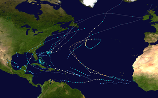
The 2000 Atlantic hurricane season was a fairly active hurricane season, but featured the latest first named storm in a hurricane season since 1992. The hurricane season officially began on June 1, and ended on November 30. It was slightly above average due to a La Niña weather pattern although most of the storms were weak. It was also the only season to have two of the storms affect Ireland. The first cyclone, Tropical Depression One, developed in the southern Gulf of Mexico on June 7 and dissipated after an uneventful duration. However, it would be almost two months before the first named storm, Alberto, formed near Cape Verde; Alberto also dissipated with no effects on land. Several other tropical cyclones—Tropical Depression Two, Tropical Depression Four, Chris, Ernesto, Nadine, and an unnamed subtropical storm—did not impact land. Five additional storms—Tropical Depression Nine, Florence, Isaac, Joyce, and Leslie—minimally affected land areas.
Tropical Storm Arlene was an unusually large and early-forming tropical storm, being the first of twenty-eight different storms during the 2005 Atlantic hurricane season, which would become the second most active season on record. Tropical Storm Arlene formed near Honduras on June 8 and moved northwards. It crossed western Cuba on June 10 and strengthened to just under hurricane strength before making its final landfall on the Florida Panhandle the next day. The storm weakened as it continued to move north over the United States, becoming extratropical on June 13. Arlene was responsible for two deaths and minor damage.

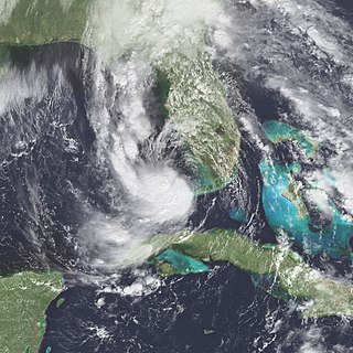
Tropical Storm Leslie was a weak, short-lived tropical cyclone that was never well-organized; however, its precursor was costlier than any other tropical cyclone in the 2000 Atlantic hurricane season. The twelfth named storm of the season, Leslie formed on October 4 over eastern Florida as a subtropical cyclone, out of a trough of low pressure. Strengthening over open waters, it attained enough tropical characteristics to be reclassified as Tropical Storm Leslie on October 5. The storm reached peak winds of 45 mph (75 km/h) before wind shear weakened it, and on October 7 transitioned into an extratropical cyclone over the open Atlantic Ocean. Leslie lasted three more days before losing its identity.

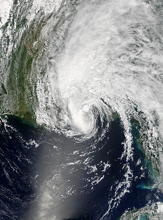
Hurricane Gabrielle was a North Atlantic hurricane that caused flooding in both Florida and Newfoundland in September 2001. It developed in the Gulf of Mexico on the same day as the September 11 attacks; after the attacks, flights were canceled nationwide for two days, and when Gabrielle struck Florida on September 14, it caused a day of additional cancellations. The storm moved ashore with winds of 70 mph (110 km/h) near Venice, a city located south of the Tampa Bay area. The combination of the winds and heavy rainfall, which peaked at 15.1 in (380 mm) in Parrish, left 570,000 customers without power along the west coast and 126,000 customers without power on the east coast. The storm caused about $230 million (2001 USD) in damage in Florida. In the Gulf of Mexico, high waves contributed to two deaths, one of which was indirect; there was also a death due to flooding in Winter Haven.

Tropical Storm Jerry was a tropical storm that caused severe flooding throughout the southeast United States in August of the 1995 Atlantic hurricane season. Jerry, the tenth tropical storm of the season, formed from a tropical wave that moved off the African coast in early August, which organized into a tropical depression and tropical storm between the Bahamas and Florida later in the month, before striking Florida in the latter part of the month. Its remnant circulation persisted until five days after landfall. The rainfall it produced, amounting to over 12 inches (300 mm) in several locations across Florida, Georgia, and South Carolina, was responsible for $40 million (2005 USD) in damage and 6 deaths. At the time, Jerry was the earliest tenth storm to form in a season on record, until Jose in the 2005 season overtook it. Tropical Storm Jerry was also the first tropical cyclone to make landfall in South Florida since Hurricane Andrew in 1992.

Tropical Depression Fourteen was the last tropical depression of the 1987 Atlantic hurricane season and was the third most destructive storm of the year. The depression formed on October 31, 1987, in the Caribbean Sea, heading along a northward path into the southern Gulf of Mexico and into Florida until the system was absorbed on November 4. The path and damage from the depression followed a similar path to Hurricane Floyd earlier in October. The depression peaked in intensity with wind speeds of 35 mph (56 km/h) on November 1 with a minimal barometric pressure reading of 1,004 millibars (29.6 inHg). However, certain barometric readings have considered that the depression may have become a tropical storm.

Tropical Storm Alberto was the first tropical storm of the 2006 Atlantic hurricane season. Forming on June 10 in the northwestern Caribbean, the storm moved generally to the north, reaching a maximum intensity of 70 mph (110 km/h) before weakening and moving ashore in the Big Bend area of Florida on June 13. Alberto then moved through eastern Georgia, North Carolina, and Virginia as a tropical depression before becoming extratropical on June 14.
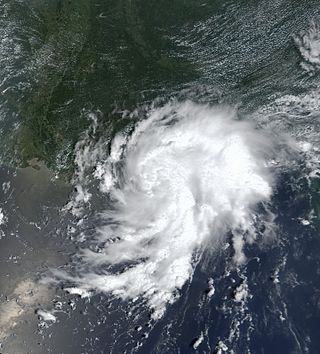
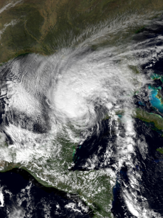
Tropical Storm Helene was a long-lived tropical cyclone that oscillated for ten days between a tropical wave and a 70 mph (110 km/h) tropical storm. It was the twelfth tropical cyclone and eighth tropical storm of the 2000 Atlantic hurricane season, forming on September 15 east of the Windward Islands. After degenerating into a tropical wave, the system produced flooding and mudslides in Puerto Rico. It reformed into a tropical depression on September 19 south of Cuba, and crossed the western portion of the island the next day while on the verge of dissipation. However, it intensified into a tropical storm in the Gulf of Mexico, reaching its peak intensity while approaching the northern Gulf Coast.

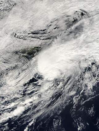
Hurricane Kyle was the fifth-longest-lived Atlantic tropical or subtropical cyclone on record. The eleventh named storm and third hurricane of the 2002 Atlantic hurricane season, Kyle developed as a subtropical cyclone on September 20 to the east-southeast of Bermuda. Looping westward, it transitioned into a tropical cyclone and became a hurricane on September 25. For the next two weeks, Kyle tracked generally westward, oscillating in strength several times because of fluctuations in environmental conditions. On October 11, the cyclone turned northeastward and made landfalls near Charleston, South Carolina, and Long Beach, North Carolina, at tropical storm status. After lasting as a cyclone for 22 days, Kyle dissipated on October 12 as it was absorbed by an approaching cold front.
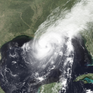
Tropical Storm Bertha was a minimal tropical storm that made landfall twice along the Gulf Coast of the United States in August 2002. The second tropical storm of the 2002 Atlantic hurricane season, Bertha developed in the northern Gulf of Mexico out of a trough of low pressure that extended into the Atlantic on August 4. It quickly organized and reached tropical storm strength before making landfall on southeastern Louisiana. Bertha turned to the southwest over the state, and re-entered the Gulf of Mexico on August 7. It remained disorganized due to proximity to land, and after making landfall on south Texas, Bertha dissipated on August 9.
Tropical Storm Marco was the only tropical cyclone to make landfall on the United States during the 1990 Atlantic hurricane season. The 13th named storm of the season, Marco formed from a cold-core low pressure area along the northern coast of Cuba on October 9, and tracked northwestward through the eastern Gulf of Mexico. With most of its circulation over the western portion of Florida, Tropical Storm Marco produced 65 mph (105 km/h) winds over land. However, it weakened to a tropical depression before moving ashore near Cedar Key. The cyclone combined with a cold front and the remnants of Hurricane Klaus to produce heavy rainfall in Georgia and the Carolinas. After interacting with the nearby Hurricane Lili, Marco continued northward until being absorbed by a cold front on October 13.
Hurricane Florence was the third of four named tropical cyclones to make landfall on the United States during the 1988 Atlantic hurricane season. The seventh tropical storm and second hurricane of the season, Florence developed on September 7 from an area of convection associated with a dissipating frontal trough in the southern Gulf of Mexico. After initially moving eastward, the storm turned northward and strengthened. Florence reached hurricane status and later peak winds of 80 mph (130 km/h) on September 9 shortly before striking southeastern Louisiana. The storm rapidly weakened over land and dissipated on September 11 over northeastern Texas.
Tropical Storm Keith struck the Continental United States later in the calendar year than any tropical cyclone since the 1925 Atlantic hurricane season. The nineteenth tropical depression and eleventh named storm of the 1988 Atlantic hurricane season, Keith developed out of a tropical wave in the Caribbean Sea on November 17. It tracked northwestward, and under generally favorable conditions, Keith reached a peak intensity of 70 mph (110 km/h) shortly before striking the northeastern tip of the Yucatán Peninsula. It turned northeastward in the Gulf of Mexico, and made landfall near Sarasota, Florida, on November 23. Keith accelerated its forward motion under the influence of a cold front, and became extratropical near Bermuda on November 24. The extratropical remnant persisted for two more days.

Tropical Storm Beryl was an unusual Atlantic tropical cyclone that formed over southeastern Louisiana in August 1988. The second tropical storm of the 1988 Atlantic hurricane season, Beryl developed from a slow-moving trough of low pressure on August 8. It tracked southeastward into the coastal waters of eastern Louisiana, and Beryl reached peak winds of 50 mph (80 km/h) while located about 75 miles (121 km) southeast of New Orleans. The storm turned to the northwest over Louisiana and Texas, and slowly dissipated. The remnants of Beryl continued northward into the central United States, dropping some rainfall and providing relief to a severe heat wave.
Tropical Storm Barry was a rapidly forming tropical cyclone that made landfall on Florida, United States, in early June 2007. The second named storm of the 2007 Atlantic hurricane season, Barry developed from a trough of low pressure in the southeastern Gulf of Mexico on June 1. It tracked rapidly northeastward, reaching peak winds of 60 mph (97 km/h) before weakening and making landfall near Tampa Bay as a tropical depression. Barry quickly lost tropical characteristics after wind shear removed much of the convection, and early on June 3, it completed the transition into an extratropical cyclone. The extratropical remnants tracked up the East Coast of the United States, and were absorbed by a larger extratropical cyclone on June 5.
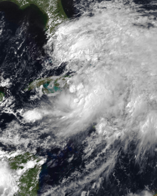
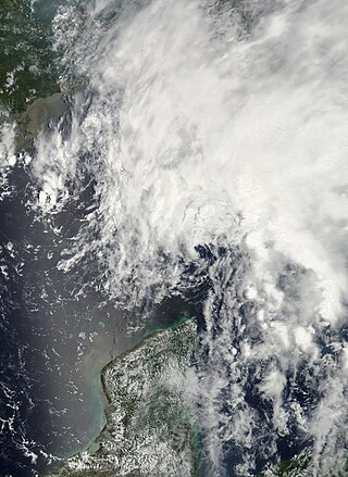
Tropical Depression One was a weak tropical cyclone that struck Cuba and the Bahamas in May and June of 1993. It formed in the western Caribbean Sea on May 31 and produced heavy rainfall along its path. In Cuba, the precipitation reached 12.4 inches (31 cm), which caused widespread flooding and damage in nine provinces. Over 16,500 houses were damaged, and a further 1,860 were destroyed. At least seven people were killed in the country. In the neighboring country Haiti, the flooding killed thirteen people, as well as thousands of livestock. Rainfall was also reported in southern Florida, which eased drought conditions. The depression eventually crossed the Bahamas and became extratropical.

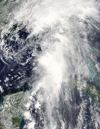
Tropical Depression One was the wettest tropical cyclone in Cuba since Hurricane Flora of 1963. The first tropical cyclone of the 1988 Atlantic hurricane season, the system developed on May 30 from an area of disturbed weather in the northwestern Caribbean Sea. The tropical depression headed northeastward, making landfall in La Habana Province, Cuba, without intensifying. Crossing Cuba, the depression became very disorganized as it emerged into the Straits of Florida and degenerated into an open trough on June 2. Although only a tropical depression, the system flooded central and western Cuba with over 40 inches (1000 mm) of rain, causing 37 fatalities, damage to over 1,000 houses, and the evacuation of about 65,000 residents.
Tropical Storm Colin was the earliest third named storm in the Atlantic basin on record for four years, until it was surpassed by Tropical Storm Cristobal in 2020. An atypical, poorly organized tropical cyclone, Colin developed from a low pressure area over the Gulf of Mexico near the northern coast of the Yucatán Peninsula late on June 5, 2016. Moving northward, the depression strengthened into a tropical storm about eight hours after its formation. On June 6, Colin curved to the north-northeast and intensified slightly to winds of 50 mph (80 km/h). Strong wind shear prevented further strengthening and resulted in the system maintaining a disheveled appearance on satellite imagery. Later, the storm began accelerating to the northeast. Early on June 7, Colin made landfall in rural Taylor County, Florida, still at peak intensity. The system rapidly crossed northern Florida and emerged into the Atlantic Ocean several hours later. By late on June 7, Colin transitioned into an extratropical cyclone offshore North Carolina before being absorbed by a frontal boundary the following day.

Tropical Storm Alberto was a destructive pre-season tropical cyclone which caused $125 million in damage in the Gulf Coast of the United States in May 2018, the costliest for any pre-season tropical cyclone. The first storm of the 2018 Atlantic hurricane season, Alberto developed on May 25 near the Yucatán Peninsula as a subtropical cyclone. As it entered the Gulf of Mexico, Alberto intensified and transitioned into a tropical cyclone. Early on May 28, Alberto reached its peak intensity, with maximum sustained winds of 65 mph (100 km/h) and a minimum pressure of 990 mbar. Afterward, however, dry air caused Alberto to weaken before it made landfall near Laguna Beach, Florida, with winds of 45 mph (75 km/h). Alberto maintained a compact area of thunderstorms as it progressed through the central United States, entering southern Michigan as a tropical depression on May 31. That day, Alberto weakened further and dissipated over Ontario.


