
The 1977 Atlantic hurricane season was a very inactive Atlantic hurricane season, with only six named storms. The season officially began on Wednesday, June 1, 1977 and lasted until Wednesday, November 30, 1977. These dates conventionally delimit the period of each year when most tropical cyclogenesis occurs in the Atlantic basin. The first tropical cyclone of the season developed over the western Caribbean Sea on June 13, 12 days after the start of the season. Three more organized during July and early August. Then, on August 29, the first named storm, Hurricane Anita formed and rapidly intensified to a Category 5 hurricane on September 1, before weakening slightly and striking Mexico as a high-end Category 4 hurricane on the Saffir–Simpson hurricane wind scale, bringing strong winds and heavy rainfall, causing 11 fatalities and leaving at least 25,000 people homeless.

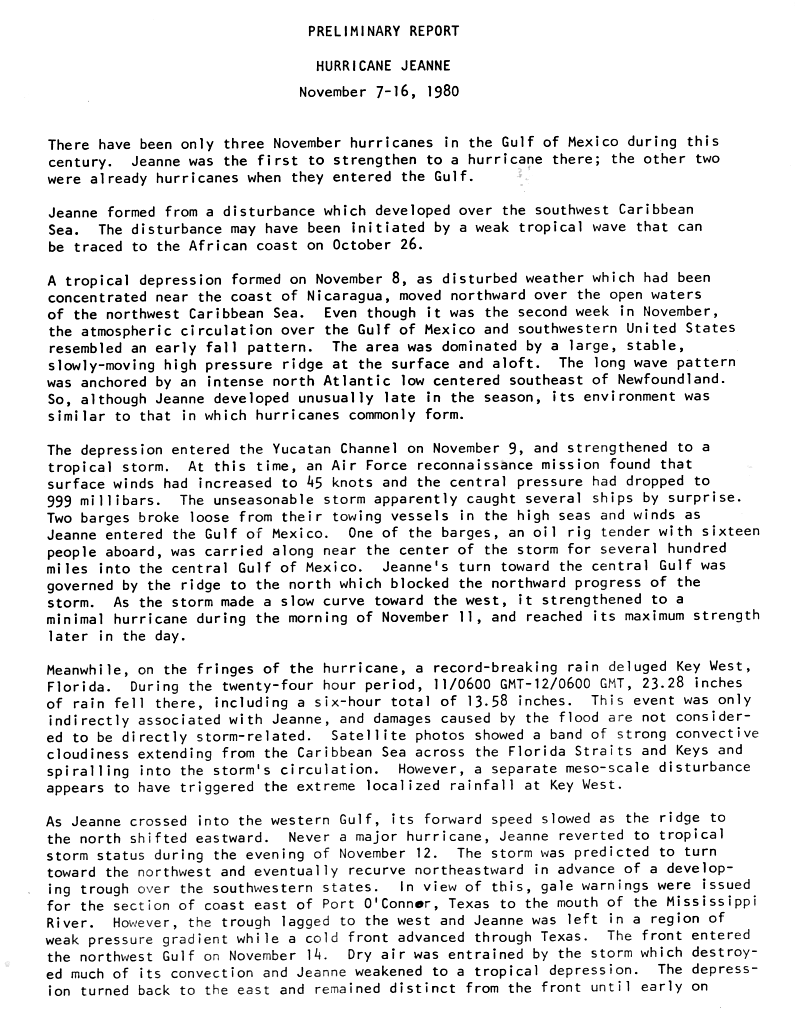
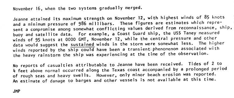
The 1980 Atlantic hurricane season featured nine hurricanes, the most since 1969. This hurricane season was fairly active, with sixteen tropical cyclones forming, eleven of which strengthened into named tropical storms. The season officially began on June 1, 1980, and lasted until November 30, 1980. It was the first time since the 1971 season that there were no active tropical cyclones in the Atlantic basin during the month of June. The season occurred during an ENSO-neutral phase, having neither an El Niño nor a La Niña.

Hurricane Anita was a powerful tropical cyclone during the otherwise quiet 1977 Atlantic hurricane season, and the latest first named storm on record since tropical cyclones were first named in 1950. The first tropical cyclone of the season, Anita developed from a tropical wave on August 29 in the north-central Gulf of Mexico. It tracked westward into an area with conditions favorable for further development, and quickly intensified into a hurricane by late on August 30. Initially, Anita was forecast to strike Texas, though a building ridge turned it to the west-southwest. The hurricane rapidly strengthened to attain peak winds of 175 mph (280 km/h), and on September 2 Anita made landfall in eastern Tamaulipas as a Category 5 hurricane. It quickly weakened as it crossed Mexico, and after briefly redeveloping into a tropical depression in the eastern Pacific Ocean, Anita dissipated on September 4 to the south of the Baja California Peninsula. Anita was the first major hurricane to form in the Gulf of Mexico since Hurricane Eloise of 1975.

The 1947 Atlantic hurricane season was the first Atlantic hurricane season to have tropical storms labeled by the United States Air Force. The season officially began on June 16, 1947, and ended on November 1, 1947. These dates conventionally delimit the period of each year when most tropical cyclones form in the Atlantic basin. However, the first tropical cyclone developed on June 13, while the final system was absorbed by a cold front on December 1. There were 10 tropical storms; 5 of them attained hurricane status, while two became major hurricanes, which are Category 3 or higher on the modern day Saffir–Simpson scale. Operationally, the third tropical storm was considered two separate tropical cyclones, resulting in the storm receiving two names. The eighth tropical storm went undetected and was not listed in HURDAT until 2014.

The 1942 Atlantic hurricane season was one of seven seasons to feature multiple hurricane landfalls in Texas. The season officially lasted from June 16, 1942, to October 31, 1942. These dates conventionally delimit the period of each year when most tropical cyclones form in the Atlantic basin. A total of 11 tropical storms from 1943 are listed in the Atlantic hurricane database, with two additional tropical depressions. The first system of the year, a tropical depression, developed over the central Gulf of Mexico on June 3, while the last system, the Belize hurricane, dissipated over the Yucatán Peninsula on November 11. After the depression dissipated on June 3, the season remained dormant until the next system developed two months later. In mid-August, a hurricane struck Texas, causing about $790,000 (1942 USD) in damage.

The 1938 Atlantic hurricane season produced fifteen tropical cyclones, of which nine strengthened into tropical storms. Four storms intensified into hurricanes. Two of those four became major hurricanes, the equivalent of a Category 3 or greater storm on the modern day Saffir–Simpson scale. The hurricane season officially began on June 16 and ended on November 15. In 2012, as part of the Atlantic hurricane reanalysis project, meteorologists identified a previously undocumented January hurricane and September tropical storm while fine-tuning the meteorological histories of several others. However, given scant observations from ships and weather stations, significant uncertainty of tropical cyclone tracks, intensity, and duration remains, particularly for those storms that stayed at sea.

The 1936 Atlantic hurricane season was a fairly active season, with 20 tropical cyclones recorded, 17 of which became tropical storms. Seven storms became hurricanes, of which one became a major hurricane. In addition, the season was unusual in the fact that no storms moved across large portions of the Caribbean Sea. Seven storms, including three hurricanes, struck the United States.

The 1921 Atlantic hurricane season was an active hurricane season, with 12 tropical cyclones forming. Among them, seven became tropical storms, of which five strengthened into hurricanes. Furthermore, two of these strengthened into a major hurricane, Category 3 or higher on the modern-day Saffir–Simpson hurricane wind scale, the most since the 1917 season. The first system, a tropical depression, developed on June 1, while the last, a tropical storm, dissipated on November 25. Of note, three tropical cyclones co-existed with another during the season.

The 1920 Atlantic hurricane season featured tropical storms and hurricanes only in the month of September. The first system, a hurricane, developed on September 7 while the last, a tropical depression, transitioned into an extratropical cyclone on October 27. Of note, four of the six cyclones co-existed with another tropical cyclone during the season.

The 1918 Atlantic hurricane season was inactive, with a total of six tropical storms developing, four of which intensified into hurricanes. Two of the season's hurricanes made Landfall in the United States, and one became a major hurricane, which is Category 3 or higher on the modern-day Saffir–Simpson scale. Additionally, there were four suspected tropical depressions, including one that began the season on June 19 and one that ended the season when it dissipated on October 19. The early 20th century lacked modern forecasting and documentation, and thus, the hurricane database from these years may be incomplete. Four previously unknown tropical cyclones were identified using records, including historical weather maps and ship reports, while information on the known storms was amended.

The 1915 Atlantic hurricane season was an active Atlantic hurricane season in which six tropical storms developed. The first storm, which remained a tropical depression, appeared on April 29 near the Bahamas, while the final system, also a tropical depression, was absorbed by an extratropical cyclone well south of Newfoundland on October 22. Of the six tropical storms, five intensified into a hurricane, of which three further strengthened into a major hurricane. Four of the hurricanes made landfall in the United States. The early 20th century lacked modern forecasting and documentation, and thus, the hurricane database from these years may be incomplete.

The 1912 Atlantic hurricane season was an average hurricane season that featured the first recorded November major hurricane. There were eleven tropical cyclones, seven of which became tropical storms; four of those strengthened into hurricanes, and one reached major hurricane intensity. The season's first cyclone developed on April 4, while the final dissipated on November 21. The season's most intense and most devastating tropical cyclone was the final storm, known as the Jamaica hurricane. It produced heavy rainfall on Jamaica, leading to at least 100 fatalities and about $1.5 million (1912 USD) in damage. The storm was also blamed for five deaths in Cuba.

The 1909 Atlantic hurricane season was an average Atlantic hurricane season. The season produced thirteen tropical cyclones, twelve of which became tropical storms; six became hurricanes, and four of those strengthened into major hurricanes. The season's first storm developed on June 15 while the last storm transitioned into an extratropical cyclone on November 14. The most notable storm during the season formed in late August, while east of the Lesser Antilles. The hurricane devastated the Lesser Antilles, the Greater Antilles, and Mexico, leaving around 4,000 fatalities and more than $50 million (1909 USD) in damage.

The 1919 Florida Keys hurricane was a massive and damaging tropical cyclone that swept across areas of the northern Caribbean Sea and the United States Gulf Coast in September 1919. Remaining an intense Atlantic hurricane throughout much of its existence, the storm's slow movement and sheer size prolonged and enlarged the scope of the hurricane's effects, making it one of the deadliest hurricanes in United States history. Impacts were largely concentrated around the Florida Keys and South Texas areas, though lesser but nonetheless significant effects were felt in Cuba and other areas of the United States Gulf Coast. The hurricane's peak strength in Dry Tortugas in the lower Florida Keys made it one of the most powerful Atlantic hurricanes to make landfall in the United States.

The 1897 Atlantic hurricane season was an inactive season, featuring only six known tropical cyclones, four of which made landfall. There were three hurricanes, none of which strengthened into major hurricanes, which are Category 3 or higher on the modern-day Saffir–Simpson hurricane wind scale. The first system was initially observed south of Cape Verde on August 31, an unusually late date. The storm was the strongest of the season, peaking as a Category 2 hurricane with winds of 100 mph (155 km/h). While located well north of the Azores, rough seas by the storm sunk a ship, killing all 45 crewmen. A second storm was first spotted in the Straits of Florida on September 10. It strengthened into a hurricane and tracked northwestward across the Gulf of Mexico, striking Louisiana shortly before dissipating on September 13. This storm caused 29 deaths and $150,000 (1897 USD) in damage.

The 1947 Fort Lauderdale hurricane(Air Weather Service designation: George) was a long-lived and an intense tropical cyclone that affected the Bahamas, southernmost Florida, and the Gulf Coast of the United States in September 1947. The fourth Atlantic tropical cyclone of the year, it formed in the eastern Atlantic Ocean on September 4, becoming a hurricane, the third of the 1947 Atlantic hurricane season, less than a day later. After moving south by west for the next four days, it turned to the northwest and rapidly attained strength beginning on September 9. It reached a peak intensity of 145 mph (233 km/h) on September 15 while approaching the Bahamas. In spite of contemporaneous forecasts that predicted a strike farther north, the storm then turned to the west and poised to strike South Florida, crossing first the northern Bahamas at peak intensity. In the Bahamas, the storm produced a large storm surge and heavy damage, but with no reported fatalities.
The New Orleans Hurricane of 1915 was an intense Category 4 hurricane that made landfall near Grand Isle, Louisiana, and the most intense tropical cyclone during the 1915 Atlantic hurricane season. The storm formed in late September when it moved westward and peaked in intensity of 145 mph (233 km/h) to weaken slightly by time of landfall on September 29 with recorded wind speeds of 126 mph (203 km/h) as a strong category 3 Hurricane. The hurricane killed 275 people and caused $13 million in damage.

The 1885 Atlantic hurricane season ran through the summer and the first half of fall in 1885. This is the period of each year when most tropical cyclones form in the Atlantic basin. In 1885 there were two tropical storms and six hurricanes in the Atlantic basin. However, in the absence of modern satellite monitoring and remote-sensing technologies, only storms that affected populated land areas or encountered ships at sea were recorded, so the actual total could be higher. An undercount bias of zero to six tropical cyclones per year between 1851 and 1885 and zero to four per year between 1886 and 1910 has been estimated.

The 1941 Texas hurricane, the second storm of the 1941 Atlantic hurricane season, was a large and intense tropical cyclone that struck coastal Texas as a major hurricane in September 1941, causing relatively severe damage. The storm is estimated to have formed in the eastern Gulf of Mexico on September 16. After attaining hurricane strength, it completed a clockwise loop and turned northwestward. The hurricane continued to strengthen until it made landfall near East Matagorda Bay, Texas, with winds of 125 miles per hour (201 km/h), but rapidly weakened as it headed inland. Damage from the storm amounted to about $6.5 million, and crops throughout the region were largely destroyed. The city of Houston suffered extensive damage as the storm passed to the east. The hurricane disrupted activities related to the Louisiana Maneuvers. Later, the system became extratropical and passed over Lake Huron, killing three people in Toronto. Overall, seven people lost their lives due to the cyclone.

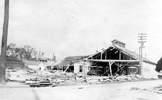
The 1926 Louisiana hurricane caused widespread devastation to the United States Gulf Coast, particularly in Louisiana. The third tropical cyclone and hurricane of the 1926 Atlantic hurricane season, it formed from a broad area of low pressure in the central Caribbean Sea on August 20. Moving to the northwest, the storm slowly intensified, reaching tropical storm strength on August 21 and subsequently attaining hurricane strength after passing through the Yucatán Channel. The hurricane steadily intensified as it recurved northwards in the Gulf of Mexico, before reaching peak intensity just prior to landfall near Houma, Louisiana on August 25 with winds of 115 mph (185 km/h). After moving inland, the tropical cyclone moved to the west and quickly weakened, before dissipating on August 27.


