Hurricane Josephine (1984)

Last updated

Map key
  Tropical depression (≤38 mph, ≤62 km/h)
  Tropical storm (39–73 mph, 63–118 km/h)
  Category 1 (74–95 mph, 119–153 km/h)
  Category 2 (96–110 mph, 154–177 km/h)
  Category 3 (111–129 mph, 178–208 km/h)
  Category 4 (130–156 mph, 209–251 km/h)
  Category 5 (≥157 mph, ≥252 km/h)
  Unknown
Storm type
Disc Plain black.svg Tropical cyclone
Solid black.svg Subtropical cyclone
ArrowUp.svg Extratropical cyclone, remnant low, tropical disturbance, or monsoon depression

A frontal trough moved eastward off the southeastern United States on September 30, becoming stationary north of Haiti. The trough developed an area of disturbed weather that interacted with an upper-level low pressure area, resulting in the development of a subtropical depression on October 7. Upon formation, the system consisted of a very broad subtropical low, as well as a poorly defined surface circulation. As the subtropical depression drifted westward, it became further organized. By midday on October 8, an Air Force reconnaissance aircraft flight indicated that the subtropical depression intensified and acquired enough tropical characteristics to be considered a tropical storm. The National Hurricane Center named the storm Josephine. [1]

Further intensification was slow, as Josephine was very large and existed in a relatively cool environment. Shortly thereafter, Josephine curved northward to the northeast of the Bahamas. By October 10, Josephine had strengthened into a hurricane. Josephine continued north-northeastward, and became a Category 2 hurricane on October 11. Winds increased slightly, and Josephine reached its maximum sustained winds of 105 mph (169 km/h) on October 12. Josephine weakened back to a Category 1 hurricane on October 13. That day, an area of high pressure moved off the northeastern United States, which caused Josephine to decelerate and abruptly curve northeastward, and eventually southeastward. By October 15, Josephine began to accelerate east-northeastward. Later that day, Josephine reached its minimum barometric pressure of 965 mbar (28.5 inHg). [1]

As Josephine continued east-northeastward, it had weakened back into a tropical storm. Under the influence of an area of high pressure to the north and a nearby area of low pressure, Josephine began executing a cyclonic loop to the north while approaching Atlantic Canada. During the cyclonic loop, it transitioned into an extratropical cyclone on October 18. Shortly thereafter, the remnants of Josephine merged with a broad mid-latitude trough. The remnants of Josephine tracked southward and completed the cyclonic loop on October 19. The system eventually curved to the east-northeastward and moved in that direction until it became unidentifiable on October 21. [1]

Preparations and impact

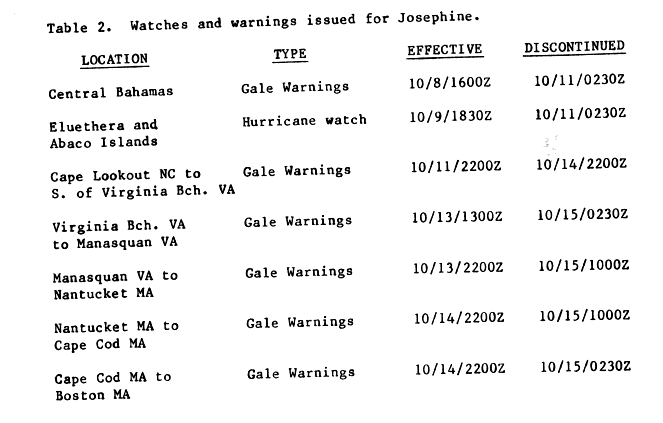
Shortly after the system was declared a tropical storm, gale warnings were issued for the central Bahamas starting on October 8. Slightly more than 24 hours later, a hurricane watch was issued on Eleuthera and the Abaco Islands. By early on October 11, both of the alerts were discontinued. Later that day, gale warnings were issued from Cape Lookout, North Carolina to Virginia Beach, Virginia. The warning area was extended to as far north as Nantucket, Massachusetts on October 13. The warning for the area from Cape Lookout, North Carolina to Virginia Beach, Virginia was discontinued late on October 14. Simultaneously, gale warnings were issued from Nantucket to Cape Cod, Massachusetts. In addition, another gale warning was also issued from Cape Cod to Boston, Massachusetts. By October 15, all gale warnings were discontinued. [2] Early in the hurricane's duration, NASA developed a contingency plan for delaying a landing of the space shuttle Challenger by a day in the event Josephine passed near Kennedy Space Center. [3] The shuttle crew filmed the hurricane from orbit using an IMAX camera. This footage of the storm was featured in the 1985 IMAX documentary The Dream is Alive.

Although Josephine remained well offshore of the eastern United States, the storm produced strong winds and high seas in combination with an area of high pressure. On the Outer Banks of North Carolina, strong winds were reported from October 11 to October 14. At Diamond Shoals, sustained winds were at 58 mph (93 km/h), with gusts as high as 75 mph (121 km/h). However, most of the damage caused by Josephine was due to high tides along the East Coast of the United States. On Hatteras Island, tides were 5.8 ft (1.8 m) above the mean sea level. In addition, wave heights of 8 to 12 ft (2.4 to 3.7 m) were reported on the island. Due to the tides, over-wash occurred on highways along the Outer Banks, which in turn caused those roads to close. Coastal erosion was also occurred in that area; most notably, the tides washed away nearly all protective sand dunes built by the Civilian Conservation Corps during the Great Depression, especially in the Rodanthe area. In the absence of protective sand dunes, the Outer Banks became vulnerable to future storms that would also produce high tides. Minor damage to houses were reported due to high tides near Nags Head and Kill Devil Hills; damage was mostly from the detachment of steps and porches. [4]

Effects were somewhat lighter in Virginia. Gale-force winds were also observed in the state, with winds of 46–52 mph (74–84 km/h) being reporting at Cape Henry and Chesapeake Light, respectively. High tides also occurred in Virginia, with waves of 9 to 10 ft (2.7 to 3.0 m) reported at Chesapeake Light. [4] Tidal flooding was reported in Delaware. In response to the hurricane, the United States Coast Guard activated extra workers in the event of any storm emergencies. High winds in Sea Bright, New Jersey washed an abandoned cabin cruiser into the jetty along the coast. [5] In the same town, officials closed a portion of New Jersey Route 36. Helicopters evacuated three coast guardsmen from Ambrose Light in New York Harbor and two guardsmen from West Bank Light. [6] Tides between 2 and 4 ft (0.61 and 1.22 m) above normal resulted in minor coastal flooding on Long Island, New York and in parts of New Jersey. Officials closed 1.5 mi (2.4 km) of a road in Southampton due to 3.5 ft (1.1 m) deep flooding. In Massachusetts, a man fell off his boat and drowned while sailing the North River amidst large swells produced by Josephine. The outer fringes of the storm produced wind and rainfall in Cape Cod. [7] In Newfoundland, Josephine dropped light rainfall, peaking at slightly less than 1 in (25 mm). [8]

Josephine also caused major effects to marine interests. High waves, estimated to have exceeded 15 ft (4.6 m), disabled a sailboat with a crew of six on it. They were quickly rescued after issuing a distress signal to a nearby tanker vessel. [9] The storm caused the loss of 1,799 bags of sorghum from water damage when a freighter encountered Josephine en route to Baltimore, Maryland. [10] The major shipping lanes of North America were severely impacted, with more than 25 ships reporting winds of at least 58 mph (93 km/h) over a period of nine days. Furthermore, at least five of those ships reported hurricane-force winds during a period of six days. The highest wind speed reported from a ship was 92 mph (148 km/h), which was observed on October 16. [4]

See also

Related Research Articles

<span class="mw-page-title-main">1967 Atlantic hurricane season</span> Hurricane season in the Atlantic Ocean

The 1967 Atlantic hurricane season was the first Atlantic hurricane season to be part of the modern-day satellite era. With 13 named storms, it was an above average season in terms of named storms, slightly above average in terms of hurricanes (6), and below average in terms of major hurricanes, with only one; Beulah. The season began on June 1, 1967, and ended on November 30, 1967, which delimits the time boundaries when tropical cyclones in the North Atlantic Ocean typically form. The first depression originated on June 10, and the final storm – Heidi – lost tropical characteristics on October 31.

<span class="mw-page-title-main">1984 Atlantic hurricane season</span> Hurricane season in the Atlantic Ocean

The 1984 Atlantic hurricane season was the most active since 1971, though the season was below average in hurricanes and major hurricanes. It officially began on June 1, 1984, and lasted until November 30, 1984. These dates conventionally delimit the period of each year when most tropical cyclones form in the Atlantic basin. The 1984 season was an active one in terms of named storms, but most of them were weak and stayed at sea. Most of the cyclones tracked through the northwest subtropical Atlantic west of the 50th meridian to near the Eastern coast of the United States between mid-August and early October. The most damaging storm was Hurricane Klaus, which caused $152 million (1984 dollars) in damage in Puerto Rico. Hurricane Diana was the first hurricane to strike a nuclear power plant without incident; it was also the first major hurricane to strike the U.S. East Coast in nearly 20 years. Also of note was Hurricane Lili, which lasted well after the official end of the season. It was downgraded from a named storm on December 24. Damage overall from the tropical cyclones in 1984 totaled $228.7 million. Unusually, no hurricanes developed from tropical waves in 1984, which usually are the source of the strongest storms in an Atlantic hurricane season.

<span class="mw-page-title-main">1990 Atlantic hurricane season</span> Hurricane season in the Atlantic Ocean

The 1990 Atlantic hurricane season was the most active Atlantic hurricane season since 1969, with a total of 14 named storms. The season also featured eight hurricanes, one of which intensified into a major hurricane. It officially began on June 1, 1990, and lasted until November 30, 1990. These dates conventionally delimit the period of each year when most tropical cyclones form in the Atlantic basin. However, tropical cyclogenesis can occur prior to the start of the season, as demonstrated with Tropical Depression One, which formed in the Caribbean Sea on May 24.

<span class="mw-page-title-main">1948 Atlantic hurricane season</span> Hurricane season in the Atlantic Ocean

The 1948 Atlantic hurricane season featured the first tropical cyclone before the month of June since 1940. The season officially began on June 15, 1948, and lasted until November 15, 1948. These dates conventionally delimit the period of each year when most tropical cyclones form in the Atlantic basin. There were 10 tropical cyclones; six storms attained hurricane status, and four storms intensified into major hurricanes, which are Category 3 or higher on the modern-day Saffir–Simpson hurricane wind scale. Operationally, it was believed that a weak tropical disturbance formed over the southeast Bahamas in May and moved northwest into the Georgia coast near Savannah. This system was later excluded from HURDAT. The seventh tropical cyclone was not operationally considered a tropical cyclone, but was later added to HURDAT.

<span class="mw-page-title-main">1936 Atlantic hurricane season</span> Hurricane season in the Atlantic Ocean

The 1936 Atlantic hurricane season was a fairly active season, with 20 tropical cyclones recorded, 17 of which became tropical storms. Seven storms became hurricanes, of which one became a major hurricane. In addition, the season was unusual in the fact that no storms moved across large portions of the Caribbean Sea. Seven storms, including three hurricanes, struck the United States.

<span class="mw-page-title-main">1923 Atlantic hurricane season</span> Hurricane season in the Atlantic Ocean

The 1923 Atlantic hurricane season featured 11 tropical cyclones, 9 of which intensified into tropical storms, the most since 1916. Four of the tropical storms intensified into hurricanes, one of which reached major hurricane intensity—Category 3 or higher on the modern-day Saffir–Simpson hurricane wind scale. No tropical storms or hurricanes formed in or entered the Caribbean Sea. The first known system, a tropical depression, formed on June 19, while the last known system, a tropical storm, transitioned into an extratropical cyclone on October 26. A total of Additionally, an October tropical depression was previously recognized as a tropical storm until reanalysis in 2009, while the first and third tropical storms were added to the Atlantic hurricane database that year. The sixth, seven, and eight storms as well as the October tropical depression existed simultaneously on October 16.

<span class="mw-page-title-main">Hurricane Ginny</span> Category 2 Atlantic hurricane in 1963

Hurricane Ginny was the strongest recorded tropical cyclone to make landfall in Canada, as well as the latest hurricane on a calendar year to affect the U.S. state of Maine. The eighth tropical storm, as well as the seventh and final hurricane of the 1963 Atlantic hurricane season, Ginny developed on October 16 over the Bahamas, although it was not initially a fully tropical cyclone. As it moved to the North and later northwest, Ginny intensified to hurricane status as it became more tropical. For eight days, it was located within 250 mi (400 km) of the United States coastline. After approaching North Carolina, Ginny looped to the southwest and approached within 50 mi (80 km) of the Florida coastline. It turned to the North, to the East, and later to the northeast, strengthening late in its duration to peak winds of 110 mph (175 km/h). Ginny became an extratropical cyclone shortly after striking Nova Scotia at its peak intensity on October 29.

<span class="mw-page-title-main">1897 Atlantic hurricane season</span> Hurricane season in the Atlantic Ocean

The 1897 Atlantic hurricane season was an inactive season, featuring only six known tropical cyclones, four of which made landfall. There were three hurricanes, none of which strengthened into major hurricanes, which are Category 3 or higher on the modern-day Saffir–Simpson hurricane wind scale. The first system was initially observed south of Cape Verde on August 31, an unusually late date. The storm was the strongest of the season, peaking as a Category 2 hurricane with winds of 100 mph (155 km/h). While located well north of the Azores, rough seas by the storm sunk a ship, killing all 45 crewmen. A second storm was first spotted in the Straits of Florida on September 10. It strengthened into a hurricane and tracked northwestward across the Gulf of Mexico, striking Louisiana shortly before dissipating on September 13. This storm caused 29 deaths and $150,000 (1897 USD) in damage.

<span class="mw-page-title-main">Hurricane Diana (1984)</span> Category 4 Atlantic hurricane in 1984

Hurricane Diana was the first major hurricane to hit the East Coast of the United States in nearly 20 years. Diana was the ninth tropical cyclone, fourth named storm, first hurricane, and first major hurricane of the 1984 Atlantic hurricane season. It caused moderate damage in North Carolina while it looped offshore and after it made landfall as a Category 2 hurricane. Forming on September 8, Diana moved northward and wandered across North Carolina for a couple of days during mid-September, dropping heavy rainfall. Once it left the state and accelerated east-northeast, Diana quickly evolved into an extratropical cyclone. Watches and warnings were issued for the storm along the East coast between eastern Florida and Virginia. Damages to the United States totaled $65.5 million. Three indirect fatalities were caused by the cyclone.

<span class="mw-page-title-main">Hurricane Esther</span> Category 5 Atlantic hurricane in 1961

Hurricane Esther was the first large tropical cyclone to be discovered by satellite imagery. The fifth tropical cyclone, named storm, and hurricane of the 1961 Atlantic hurricane season, Esther developed from an area of disturbed weather hundreds of miles west-southwest of the southernmost Cape Verde Islands on September 10. Moving northwestward, the depression strengthened into Tropical Storm Esther on September 11, before reaching hurricane intensity on the following day. Early on September 13, Esther curved westward and deepened into a major hurricane. The storm remained a Category 3 hurricane for about four days and gradually moved in a west-northwestward direction. Late on September 17, Esther strengthened into a Category 5 hurricane with sustained winds of 160 mph (260 km/h) on September 18. The storm curved north-northeastward on September 19, while offshore of North Carolina. Esther began to weaken while approaching New England and fell to Category 3 intensity on September 21. The storm turned eastward early on the following day, and rapidly weakened to a tropical storm.

<span class="mw-page-title-main">Hurricane Charley (1986)</span> Category 1 Atlantic hurricane

Hurricane Charley was the second hurricane to threaten the East Coast of the United States within a year's timeframe, after Hurricane Gloria of 1985. The third tropical storm and second hurricane of the season, Charley formed as a subtropical low on August 13 along the Florida panhandle. After moving off the coast of South Carolina, the system transitioned into a tropical cyclone and intensified into a tropical storm on August 15. Charley later attained hurricane status before moving across eastern North Carolina. It gradually weakened over the north Atlantic Ocean before transitioning into an extratropical cyclone on August 20. Charley's remnants remained identifiable for over a week, until after crossing Ireland and Great Britain they dissipated on August 30.

<span class="mw-page-title-main">1991 Perfect Storm</span> Noreaster and Category 1 Atlantic hurricane in 1991

The 1991 Perfect Storm, also known as The No-Name Storm and the Halloween Gale/Storm, was a nor'easter that absorbed Hurricane Grace, and ultimately evolved into a small unnamed hurricane itself late in its life cycle.

<span class="mw-page-title-main">Tropical Storm Gilda (1973)</span> Atlantic tropical storm in 1973

Tropical Storm Gilda in 1973 was the first documented tropical cyclone on record to transition into a subtropical cyclone. It formed on October 16 in the western Caribbean Sea from a tropical wave, and strengthened to reach peak winds of 70 mph (110 km/h) before striking Cuba. It later moved slowly through the Bahamas before weakening to tropical depression status. On October 24, with the assistance of a cold front off the coast of the eastern United States, Gilda transformed into a subtropical storm, becoming very large and strong. The storm later accelerated northeastward and became extratropical, ultimately dissipating near Greenland.

<span class="mw-page-title-main">Hurricane Gerda</span> Category 3 Atlantic hurricane in 1969

Hurricane Gerda was a North Atlantic tropical cyclone that formed during the 1969 Atlantic hurricane season. It was the seventh named storm, fifth hurricane and third major hurricane of the 1969 season. Gerda formed on September 6 and crossed Florida as a tropical depression. Gerda later became a tropical storm after making a hard right turn and moving northeast and reaching hurricane status on September 8. Gerda brushed past the Outer Banks of North Carolina before reaching maximum intensity of 120 mph (190 km/h) and a low barometric pressure of 980 millibars (29 inHg). On September 10, Gerda made landfall near Eastport, Maine, and became extratropical the following day.

<span class="mw-page-title-main">1853 Atlantic hurricane season</span> Hurricane season in the Atlantic Ocean

The 1853 Atlantic hurricane season featured eight known tropical cyclones, none of which made landfall. Operationally, a ninth tropical storm was believed to have existed over the Dominican Republic on November 26, but HURDAT – the official Atlantic hurricane database – now excludes this system. The first system, Tropical Storm One, was initially observed on August 5. The final storm, Hurricane Eight, was last observed on October 22. These dates fall within the period with the most tropical cyclone activity in the Atlantic. At two points during the season, pairs of tropical cyclones existed simultaneously. Four of the cyclones only have a single known point in their tracks due to a sparsity of data, so storm summaries for those systems are unavailable.

<span class="mw-page-title-main">Tropical Storm Amy (1975)</span> Atlantic tropical storm in 1975

Tropical Storm Amy was the first tropical cyclone to develop during the 1975 Atlantic hurricane season. Forming on June 28 from a trough of low pressure, Amy gradually attained tropical storm status off the coast of North Carolina. A rapidly approaching trough caused Amy to turn sharply eastward before the storm took a general northeastward track. On July 2, the storm reached its peak intensity with winds of 70 mph (110 km/h) and a barometric pressure of 981 mbar. During most of the storm's existence, Amy featured many subtropical characteristics but was not classified as such due to the proximity to land. By July 4, the system moved southeast of Newfoundland before becoming extratropical.

<span class="mw-page-title-main">Tropical Storm Dean (1983)</span> Atlantic tropical storm in 1983

Tropical Storm Dean caused minor flooding along portions of the East Coast of the United States in September 1983. The seventh and final tropical cyclone of the very inactive 1983 Atlantic hurricane season, Dean developed from a frontal low to the northeast of the Bahamas on September 26. Initially subtropical, it gained characteristics of a tropical cyclone while tracking slowly north-northeastward. By September 27, the system was reclassified as Tropical Storm Dean. While tracking northward on September 28, Dean peaked with winds of 65 mph (100 km/h), shortly before curving west-northwestward and slowly leveling-off in intensity. Eventually, Dean made landfall in Virginia on the Delmarva Peninsula on September 29 as a weakening tropical storm. Dean rapidly weakened over land and was no longer classifiable as a tropical cyclone by early on October 1.

<span class="mw-page-title-main">Tropical Storm Bret (1981)</span> Atlantic tropical storm in 1981

Tropical Storm Bret made a rare landfall on the Delmarva Peninsula in June 1981. The sixth tropical cyclone, third designated tropical depression, and second named storm of the season, Bret developed as a subtropical storm from a large area of frontal clouds near Bermuda on June 29. Moving westward, the subtropical storm intensified while producing deep convection, and was consequently reclassified as a tropical storm early on June 30. Around that time, Bret peaked with sustained winds of 70 mph (110 km/h). The storm then began weakening and struck near Oyster, Virginia as a minimal tropical storm early on July 1. Upon moving inland, Bret weakened to a tropical depression and subsequently accelerated prior to dissipating over northern Virginia that same day.

<span class="mw-page-title-main">Hurricane Alma (1962)</span> Category 1 Atlantic hurricane in 1962

Hurricane Alma saw the latest development of the first storm since 1941. The first named storm of the 1962 Atlantic hurricane season, Alma formed from a tropical wave located offshore South Florida on August 26. Initially a tropical depression, it subsequently moved inland over South Florida. Impact in the state was minor, generally limited to light rainfall and rough seas. Early on August 27, the depression reemerged into the Atlantic Ocean and strengthened into Tropical Storm Alma later that day. Thereafter, it moved northeastward and remained offshore the East Coast of the United States. Alma strengthened into a hurricane on August 28, while located offshore the Outer Banks of North Carolina. In the eastern portion of the state, strong winds downed electrical poles, which caused power outages. Storm tides caused erosion in some areas. Damage in North Carolina reached $35,000 (1962 USD).

<span class="mw-page-title-main">Subtropical Storm Four</span> Atlantic subtropical storm in 1974

Subtropical Storm Four brushed Florida and The Bahamas in October 1974. The eighteenth cyclone and fourth subtropical storm of the 1974 Atlantic hurricane season, the storm developed near eastern Cuba on October 4 from an area of disturbed weather. Shortly before striking Andros Island on October 6, the system strengthened into a subtropical storm. The storm made its closest approach to Florida early on October 7. Peaking with sustained winds of 50 mph (85 km/h), the system veered northward and then northeastward, but nonetheless caused heavy rainfall and coastal flooding on land in Florida. While paralleling offshore North Carolina and South Carolina, the storm began to slowly weaken. By late on October 8, the subtropical cyclone merged with a cold front while well east of Cape Hatteras.

References

  1. 1 2 3 Robert C. Sheets (October 27, 1984). "Hurricane Josephine Preliminary Report (Page 1)". National Hurricane Center . Retrieved July 9, 2011.
  2. Robert C. Sheets (October 27, 1984). "Hurricane Josephine Preliminary Report (Page 5)". National Hurricane Center. Retrieved July 10, 2011.
  3. Staff Writer (October 11, 1984). "Garneau to catch up on Canadian experiments". The Leader-Post. The Canadian Press. Retrieved July 28, 2011.
  4. 1 2 3 Robert C. Sheets (October 27, 1984). "Hurricane Josephine Preliminary Report (Page 2)". National Hurricane Center. Retrieved July 11, 2011.
  5. Staff Writer (October 15, 1984). "Josephine is still strong, but is surging eastward". Wilmington Morning Star. Retrieved July 28, 2011.
  6. Staff Writer (October 15, 1984). "East coast lashed by hurricane". The Spokesman-Review. Retrieved July 28, 2011.
  7. "Hurricane Josephine moves away from land". The Free Lance-Star. Associated Press. October 15, 1984. Retrieved January 25, 2010.
  8. "1984-Josephine". Environment Canada. September 14, 2010. Retrieved July 11, 2011.
  9. "Hurricane Josephine scaring mariners now". The Day. Associated Press. October 11, 1984. Retrieved January 22, 2010.
  10. Barry Shlachter (December 11, 1984). "Port busy around the clock to meet drought challenge". The Times-News. Associated Press. Retrieved July 28, 2011.
Hurricane Josephine
Josephine 1984-10-12 1800Z.png
Hurricane Josephine at peak intensity off the coast of North Carolina on October 12