
The 1995 Atlantic hurricane season was an extremely active Atlantic hurricane season, and is considered to be the start of an ongoing era of high-activity tropical cyclone formation. The season produced twenty-one tropical cyclones, nineteen named storms, as well as eleven hurricanes and five major hurricanes. The season officially began on June 1 and ended on November 30, dates which conventionally delimit the period of each year when most tropical cyclones develop in the Atlantic basin. The first tropical cyclone, Hurricane Allison, developed on June 2, while the season's final storm, Hurricane Tanya, transitioned into an extratropical cyclone on November 1. The very active Atlantic hurricane activity in 1995 was caused by La Niña conditions, which also influenced an inactive Pacific hurricane season.
The 1998 Atlantic hurricane season was one of the most disastrous Atlantic hurricane seasons on record, featuring the highest number of storm-related fatalities in over 218 years and one of the costliest ever at the time. The season had above average activity, due to the dissipation of the El Niño event and transition to La Niña conditions. It officially began on June 1 and ended on November 30, dates which conventionally delimit the period during which most tropical cyclones form in the Atlantic Ocean. The season had a rather slow start, with no tropical cyclones forming in June. The first tropical cyclone, Tropical Storm Alex, developed on July 27, and the season's final storm, Hurricane Nicole, became extratropical on December 1.

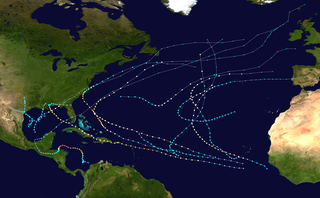
The 1996 Atlantic hurricane season had the most major hurricanes since 1950, which are Category 3 or higher on the Saffir-Simpson scale. The season was above-average, featuring a total of thirteen named storms, nine hurricanes, and six major hurricanes. The season officially began on June 1, 1996 and ended on November 30, 1996, dates which conventionally delimit the period of each year when most tropical cyclones form in the Atlantic basin. The season's first tropical cyclone, Tropical Storm Arthur, developed on June 17, while the final cyclone, Hurricane Marco dissipated on November 26. The most intense hurricane, Edouard, was a powerful Cape Verde-type hurricane that affected portions of the Mid-Atlantic states and New England. The season featured nine tropical cyclone landfalls, including six hurricanes, one of which was a major hurricane. In total, six major hurricanes formed during the 1996 Atlantic hurricane season—the highest number produced in a single season since 1950.

The 1960 Atlantic hurricane season was the least active season since 1952. The season officially began on June 15, and lasted until November 15. These dates conventionally delimit the period of each year when most tropical cyclones form in the Atlantic basin. The first system, an unnamed storm, developed in the Bay of Campeche on June 22. It brought severe local flooding to southeastern Texas and was considered the worst disaster in some towns since a Hurricane in 1945. The unnamed storm moved across the United States for almost a week before dissipating on June 29. In July, Hurricane Abby resulted in minor damage in the Leeward Islands, before impacting a few Central American counties — the remnants of the storm would go on to form Hurricane Celeste in the East Pacific. Later that month, Tropical Storm Brenda caused flooding across much of the East Coast of the United States. The next storm, Hurricane Cleo, caused no known impact, despite its close proximity to land.

The 1961 Atlantic hurricane season was a hyperactive Atlantic hurricane season, with an accumulated cyclone energy (ACE) total of 189. The season, however, was an average one in terms of named storms. The season featured eight hurricanes and a well above average number of five major hurricanes. It was previously thought that the season had a record-tying seven major hurricanes, before the Atlantic hurricane reanalysis project downgraded two storms in 2019. Two Category 5 hurricanes were seen in 1961, making it one of only seven Atlantic hurricane seasons to feature multiple Category 5 hurricanes in one season. The season started on June 15, and ended on November 15. These dates conventionally delimit the period of each year when most tropical cyclones form in the Atlantic basin. The first system, an operationally unclassified tropical depression, formed offshore east Central Florida on June 10, but dissipated a few days later. Next, Hurricane Anna developed in the eastern Caribbean Sea near the Windward Islands on July 20. It brought minor damage to the islands, as well as wind and flood impacts to Central America after striking Belize as a hurricane. Anna caused one death and about $300,000 (1961 USD) in damage. Activity went dormant for nearly a month and a half, until Hurricane Betsy developed on September 2. Betsy peaked as a Category 4 hurricane, but remained at sea and caused no impact.

The 1965 Atlantic hurricane season was the first to use the modern-day bounds for an Atlantic hurricane season, which are June 1 to November 30. These dates conventionally delimit the period of each year when most tropical cyclones form in the Atlantic basin. It was a slightly below average season, with 10 tropical cyclones developing and reaching tropical storm intensity. Four of the storms strengthened into hurricanes. One system reached major hurricane intensity – Category 3 or higher on the Saffir–Simpson hurricane scale. The first system, an unnamed tropical storm, developed during the month of June in the southern Gulf of Mexico. The storm moved northward across Central America, but caused no known impact in the region. It struck the Florida Panhandle and caused minor impact across much of the Southern United States. Tropical cyclogenesis halted for over two months, until Anna formed on August 21. The storm remained well away from land in the far North Atlantic Ocean and caused no impact.

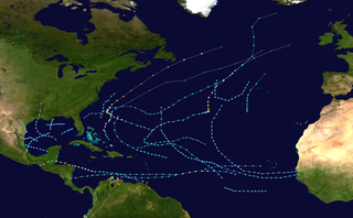
The 1992 Atlantic hurricane season was a significantly below average season in which only ten tropical or subtropical cyclones formed. Six became named tropical storms, of which four became hurricanes. Among the four was Hurricane Andrew, a major hurricane, and the costliest Atlantic hurricane on record at the time, surpassing Hugo of 1989. The season officially started on June 1 and officially ended on November 30. However, tropical cyclogenesis is possible at any time of the year, as demonstrated by formation in April of an unnamed subtropical storm in the central Atlantic. A June tropical depression caused flooding in Cuba and in Florida, where two people were killed. In August, Andrew struck the Bahamas, Florida, and Louisiana. In all, it caused $27.3 billion in damage, mostly in Florida, as well as 65 fatalities. The greatest impact was in South Florida, where the storm made landfall with 1-minute sustained winds of 175 mph (280 km/h).
The 1978 Atlantic hurricane season was a slightly above average hurricane season in terms of number of named storms. Eleven tropical cyclones were named in all, and five of these became hurricanes; two of the five became a major hurricane. This was also the last Atlantic hurricane season to use an all-female naming list. The season officially began on June 1, 1978, and ended on November 30, 1978. These dates, adopted by convention, denote the period in each year when most tropical cyclogenesis occurs in the Atlantic basin. However, the formation of subtropical or tropical cyclones is possible at any time of the year, as shown by the formation of an unnamed subtropical storm on January 18.

The 1981 Atlantic hurricane season featured direct or indirect impacts from nearly all of its 12 tropical or subtropical storms. Overall, the season was fairly active, with 22 tropical depressions, 12 of which became a namable storm, while 7 of those reached hurricane status and 3 intensified into major hurricanes. The season officially began on June 1, 1981, and lasted until November 30, 1981. These dates conventionally delimit the period of each year when most tropical cyclones form in the Atlantic basin. However, tropical cyclogenesis can occur before these dates, as demonstrated with the development of two tropical depressions in April and Tropical Storm Arlene in May. At least one tropical cyclone formed in each month between April and November, with the final system, Subtropical Storm Three, becoming extratropical on November 17, 1981.

The 1983 Atlantic hurricane season was the least active Atlantic hurricane season since 1930. The season officially began on June 1, 1983, and lasted until November 30, 1983. These dates conventionally delimit the period of each year when most storms form in the Atlantic basin. The season had very little activity, with only seven tropical depressions, four of which reached tropical storm strength or higher. This led to the lowest accumulated cyclone energy count since 1977, but not since 1914.

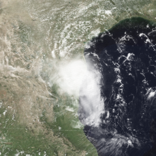
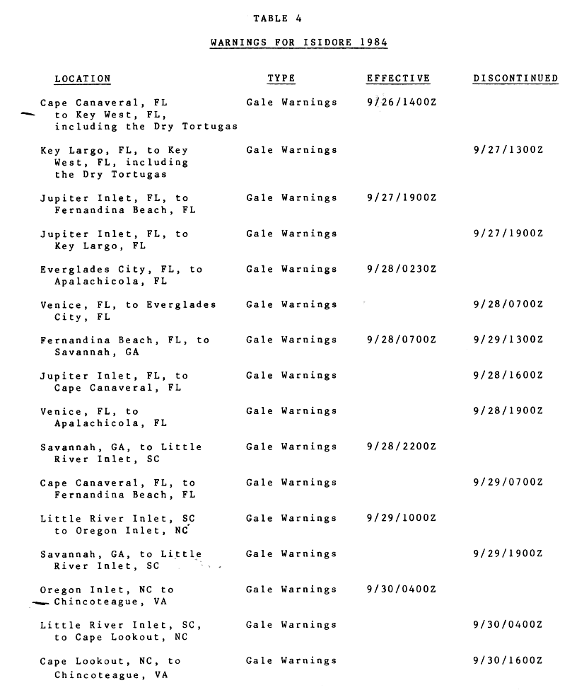
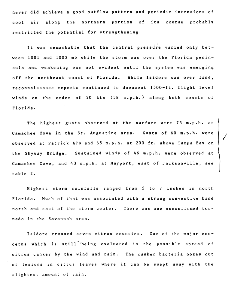
The 1984 Atlantic hurricane season was the most active since 1971, though the season was below average in hurricanes and major hurricanes. It officially began on June 1, 1984, and lasted until November 30, 1984. These dates conventionally delimit the period of each year when most tropical cyclones form in the Atlantic basin. The 1984 season was an active one in terms of named storms, but most of them were weak and stayed at sea. Most of the cyclones tracked through the northwest subtropical Atlantic west of the 50th meridian to near the Eastern coast of the United States between mid-August and early October. The most damaging storm was Hurricane Klaus, which caused $152 million (1984 dollars) in damage in Puerto Rico. Hurricane Diana was the first hurricane to strike a nuclear power plant without incident; it was also the first major hurricane to strike the U.S. East Coast in nearly 20 years. Also of note was Hurricane Lili, which lasted well after the official end of the season. It was downgraded from a named storm on December 24. Damage overall from the tropical cyclones in 1984 totaled $228.7 million. Unusually, no hurricanes developed from tropical waves in 1984, which usually are the source of the strongest storms in an Atlantic hurricane season.

The 1985 Atlantic hurricane season had six United States landfalling hurricanes, tied with 1886 and 2020 for the highest number on record. The season officially began on June 1 and lasted until November 30. It was an average season, with 11 named storms developing. This was partially attributed to a La Niña – a meteorological phenomenon that produces favorable conditions across the Atlantic basin, such as lower wind shear and higher sea surface temperatures. The first storm, Ana, developed on July 15 near Bermuda and caused minor effects in Canada while transitioning into an extratropical cyclone. Three other tropical cyclones – Claudette, Henri, and Isabel – did not significantly affect land. Claudette developed offshore of the Southeastern United States and brushed Bermuda and the Azores. Henri and Isabel were dissipating as they approached land. However, the precursor of the latter caused a severe flood in Puerto Rico that killed 180 people. Additionally, Tropical Storm Fabian and three tropical depressions did not have any known impact on land.

The 1989 Atlantic hurricane season was an average hurricane season with 11 named storms. The season officially began on June 1, and ended on November 30. The first tropical cyclone, Tropical Depression One, developed on June 15, and dissipated two days later without any effects on land. Later that month, Tropical Storm Allison caused severe flooding, especially in Texas and Louisiana. Tropical Storm Barry, Tropical Depressions Six, Nine, and Thirteen, and Hurricanes Erin and Felix caused negligible impact. Hurricane Gabrielle and Tropical Storm Iris caused light effects on land, with the former resulting in nine fatalities from rip currents offshore the East Coast of the United States and Atlantic Canada, while the latter produced minor flooding in the United States Virgin Islands.

The 1990 Atlantic hurricane season was the most active Atlantic hurricane season since 1969, with a total of 14 named storms. The season also featured eight hurricanes, one of which intensified into a major hurricane. It officially began on June 1, 1990, and lasted until November 30, 1990. These dates conventionally delimit the period of each year when most tropical cyclones form in the Atlantic basin. However, tropical cyclogenesis can occur prior to the start of the season, as demonstrated with Tropical Depression One, which formed in the Caribbean Sea on May 24.
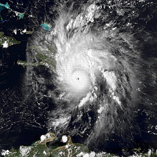
Hurricane Emily was a powerful tropical cyclone that struck Hispaniola in September 1987. It was the first hurricane in the Caribbean Sea since Hurricane Katrina of 1981 and had the second-fastest forward speed of a 20th-century hurricane, behind only the 1938 New England hurricane. The twelfth tropical cyclone, fifth named storm, second hurricane, and only major hurricane to develop during the below-average 1987 Atlantic hurricane season, Emily formed out of a tropical disturbance that moved off the west coast of Africa on September 20, the storm quickly attained hurricane status before undergoing rapid intensification. On September 22. The storm attained its peak intensity with winds of 125 mph (201 km/h) and a barometric pressure of 958 mbar later that day. The storm weakened to Category 2 status before making landfall in the Dominican Republic. After weakening to a tropical storm, Emily rapidly tracked northeastward through the Atlantic Ocean, undergoing a second phase of rapid intensification before passing directly over Bermuda on September 25. The following day the final public advisory from the National Hurricane Center was issued on the storm as it transitioned into an extratropical cyclone.

The 1987 Gulf Coast tropical storm caused flooding along the Gulf Coast of the United States. The second tropical cyclone and first tropical storm of the 1987 Atlantic hurricane season, it originated from a tropical wave in the Gulf of Mexico, southeast of Texas, on August 9. Initially a tropical depression, the cyclone moved north-northwestward and slightly intensified into a tropical storm later that day. By August 10, it made landfall between Galveston and Beaumont. The system weakened after moving inland and turned towards the east and later southeast. Briefly reemerging over the Gulf on August 15, the depression moved onshore a second time in Florida, before dissipating over eastern Georgia on August 17.

The 1987 Atlantic hurricane season was a below-average hurricane season that was limited by an ongoing El Niño. The season officially began on June 1, 1987, and lasted until November 30, 1987, although activity began on May 24 when a tropical depression developed 400 mi (640 km) east of the central Bahamas. The June through November dates conventionally delimit the period of each year when most tropical cyclones form in the Atlantic basin. The first cyclone to attain tropical storm status was an unnamed tropical storm which formed on August 9, nearly a month later than usual. The final storm of the year, Tropical Depression Fourteen, merged with a weak extratropical low on November 4. The season marked the first year tropical storm watches and warnings were issued; previously, gale watches and warnings were used for tropical storms, and this season was one of only a few seasons with no deaths in the United States; the last time this happened was in the 1981 season.
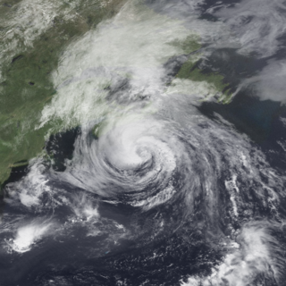
Hurricane Bertha caused minor damage in the United States, Bermuda, and Atlantic Canada in July and August 1990. The third tropical cyclone, second named storm, and first hurricane of the 1990 Atlantic hurricane season, Bertha developed from a frontal low pressure area offshore of North Carolina on July 24. Initially subtropical, it slowly acquired tropical characteristics while tracked southeast and then southwestward. By early on July 27, the cyclone was re-classified as a tropical depression. Following its transition, the depression intensified and was upgraded to Tropical Storm Bertha on July 28. The storm then curved northeastward and rapidly strengthened. Bertha became a hurricane early on July 29, though it weakened back to a tropical storm later that day. On the following day, Bertha re-intensified into a hurricane and peaked as an 80 mph (130 km/h) Category 1 hurricane on July 31.
Hurricane Barry was a moderate tropical cyclone that caused minor damage in Florida, Texas, and Mexico in late August 1983. Barry was the fourth tropical depression, second named storm and second hurricane of the inactive 1983 Atlantic hurricane season. Developing out of a tropical wave on August 23, Barry quickly strengthened off the coast of Florida, reaching an initial peak intensity with winds of 60 mph (95 km/h). However, increased wind shear caused the storm to weaken to a tropical depression before making landfall near Melbourne, Florida, the next morning. Traveling almost due west, the storm regenerated and became a hurricane on August 28. The storm made landfall on the northern Mexican coastline later that day at peak intensity. Rapid weakening followed shortly after and the storm dissipated the next day. The storm had only minor effects in the United States but destroyed hundreds of homes and left over 400 homeless in northern Mexico. Despite the damage, there were no reports of fatalities or injuries.

Hurricane Floyd was the only hurricane to make landfall in the United States in the 1987 Atlantic hurricane season. The final of seven tropical storms and three hurricanes, Floyd developed on October 9 just off the east coast of Nicaragua. After becoming a tropical storm, it moved northward and crossed western Cuba. An approaching cold front caused Floyd to turn unexpectedly to the northeast, and late on October 12 it attained hurricane status near the Florida Keys. It moved through southern Florida, spawning two tornadoes and leaving minor damage. The hurricane also produced rip tides that killed a person in southern Texas. Floyd maintained hurricane status for only 12 hours before the cold front imparted hostile conditions and caused weakening. It passed through the Bahamas before becoming extratropical and later dissipating on October 14.


