Hurricane Hortense was the first tropical cyclone to make landfall in Guadeloupe and Puerto Rico since Hurricane Hugo in 1989, and the second most intense hurricane during the 1996 Atlantic hurricane season. The eighth tropical cyclone, eighth named storm, and sixth hurricane of the season, Hortense developed on September 3 from a tropical wave in the central Atlantic Ocean. Initially a tropical depression, it headed westward without significant strengthening for four days due to unfavorable upper-level winds. While nearing the Lesser Antilles upper-level winds decreased, allowing the depression to become Tropical Storm Hortense on September 7. Hortense crossed Guadeloupe on September 8 and entered the Caribbean Sea. By on the following day, it was upgraded to a hurricane while curving northwestward. Hortense made landfall in Puerto Rico on September 9 and brushed the Dominican Republic shortly thereafter. After re-entering the Atlantic, Hortense began to substantially strengthen and peaked as a 140 mph (220 km/h) Category 4 hurricane early on September 13. Thereafter, the storm steadily weakened as it tracked rapidly north-northeastward. Early on September 15, Hortense made landfall in Nova Scotia as a minimal Category 1 hurricane. It quickly weakened further to a tropical storm before re-entering the Atlantic to the south of Newfoundland. Late on September 15, Hortense transitioned into an extratropical cyclone and subsequently merged with a frontal system about 24 hours later.

Hurricane Lenny was the strongest November Atlantic hurricane since the 1932 Cuba hurricane. It was the twelfth tropical storm, eighth hurricane, and record-breaking fifth Category 4 hurricane in the 1999 Atlantic hurricane season. Lenny formed on November 13 in the western Caribbean Sea at around 18:00 UTC and went on to form and maintain an unusual and unprecedented easterly track for its entire duration, which gave it the common nickname, "Wrong Way Lenny". It attained hurricane status south of Jamaica on November 15 and passed south of Hispaniola and Puerto Rico over the next few days. Lenny rapidly intensified over the northeastern Caribbean on November 17, attaining peak winds of 155 mph (249 km/h) about 21 mi (34 km) south of Saint Croix in the United States Virgin Islands. It gradually weakened while moving through the Leeward Islands, eventually dissipating on November 23 over the open Atlantic Ocean.

The 2003 Atlantic hurricane season was a very active season with tropical cyclogenesis occurring before and after the official bounds of the season—the first such occurrence since the 1970 season. The season produced 21 tropical cyclones, of which 16 developed into named storms; seven of those attained hurricane status, of which three reached major hurricane status. The strongest hurricane of the season was Hurricane Isabel, which reached Category 5 status on the Saffir–Simpson hurricane scale northeast of the Lesser Antilles; Isabel later struck North Carolina as a Category 2 hurricane, causing $3.6 billion in damage and a total of 51 deaths across the Mid-Atlantic region of the United States.

The 1982 Atlantic hurricane season was an extremely inactive Atlantic hurricane season with five named tropical storms and one subtropical storm. Two storms became hurricanes, one of which reached major hurricane status. The season officially began on June 1, 1982, and lasted until November 30, 1982. These dates conventionally delimit the period of each year when most tropical cyclones form in the Atlantic basin. Activity started early with Hurricane Alberto forming on the first day of the season. Alberto threatened the Southwestern Florida coast as a tropical storm, meadering offshore in the southeastern Gulf of Mexico and causing 23 fatalities in Cuba. The next system, a subtropical storm, formed later in June and affected the same area as Alberto, causing $10 million in damage.

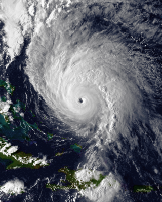
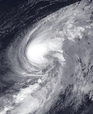
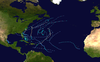
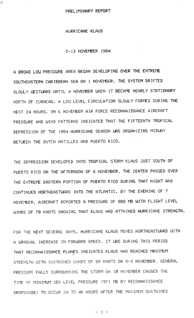
The 1984 Atlantic hurricane season was the most active since 1971, though the season was below average in hurricanes and major hurricanes. It officially began on June 1, 1984, and lasted until November 30, 1984. These dates conventionally delimit the period of each year when most tropical cyclones form in the Atlantic basin. The 1984 season was an active one in terms of named storms, but most of them were weak and stayed at sea. Most of the cyclones tracked through the northwest subtropical Atlantic west of the 50th meridian to near the Eastern coast of the United States between mid-August and early October. The most damaging storm was Hurricane Klaus, which caused $152 million (1984 dollars) in damage in Puerto Rico. Hurricane Diana was the first hurricane to strike a nuclear power plant without incident; it was also the first major hurricane to strike the U.S. East Coast in nearly 20 years. Also of note was Hurricane Lili, which lasted well after the official end of the season. It was downgraded from a named storm on December 24. Damage overall from the tropical cyclones in 1984 totaled $228.7 million. Unusually, no hurricanes developed from tropical waves in 1984, which usually are the source of the strongest storms in an Atlantic hurricane season.

Hurricane Frederic, known in Latin America as Federico, was an intense and damaging tropical cyclone that carved a path of destruction from the Lesser Antilles to Quebec, in particular devastating areas of the United States Gulf Coast. Though only five were killed directly, the US$1.77 billion in damage accrued by Frederic made it the Atlantic basin's costliest tropical cyclone on record at the time. Prior to its final landfall, the threat that Frederic imposed on areas of the U.S. Gulf Coast triggered a mass exodus from the region larger than any other evacuation in the past. While the storm primarily impacted the U.S. states of Mississippi and Alabama, lesser effects were felt throughout the Greater and Lesser Antilles, as well as inland North America.

Hurricane Jeanne was the deadliest tropical cyclone in the Atlantic basin since Mitch in 1998, and the deadliest tropical cyclone worldwide in 2004. It was the tenth named storm, the seventh hurricane, and the fifth major hurricane of the season, as well as the third hurricane and fourth named storm of the season to make landfall in Florida. After wreaking havoc on Hispaniola, Jeanne struggled to reorganize, eventually strengthening and performing a complete loop over the open Atlantic. It headed westwards, strengthening into a Category 3 hurricane and passing over the islands of Great Abaco and Grand Bahama in the Bahamas on September 25. Jeanne made landfall later in the day in Florida just two miles from where Hurricane Frances had struck a mere three weeks earlier.

Hurricane Klaus was a minimal Atlantic hurricane that dropped heavy rainfall across the Lesser Antilles in October 1990. The eleventh tropical cyclone and sixth hurricane of the 1990 Atlantic hurricane season, Klaus developed from a tropical wave on October 3 a short distance east of Dominica. It drifted northwestward, and quickly intensified to attain hurricane status on October 5. Though its closest approach to the Lesser Antilles was within 12 miles (19 km), the strongest winds remained to its northeast due to strong wind shear, which caused Klaus to steadily weaken. After deteriorating into a tropical depression, Klaus briefly restrengthened over the Bahamas before dissipating on October 9 under the influence of developing tropical storm, Marco.

Hurricane Luis was a long lived and powerful tropical cyclone that was the strongest hurricane to make landfall and the third-most intense hurricane recorded during the 1995 Atlantic hurricane season. The storm, along with Humberto, Iris, and Karen, was one of four simultaneous tropical systems in the Atlantic basin.

Tropical Storm Odette was a rare off-season tropical cyclone that hit the island of Hispaniola in early December 2003. As the fifteenth named storm of the 2003 Atlantic hurricane season, Odette formed near the coast of Panama a few days after the official end of the Atlantic hurricane season ended on November 30, and ultimately made landfall on the Dominican Republic as a moderate tropical storm, before becoming extratropical on December 7, dissipating two days later.

Hurricane Alice is the only known Atlantic hurricane to span two calendar years and one of only two named Atlantic tropical cyclones, along with Tropical Storm Zeta of 2005, to do so. The twelfth tropical cyclone and the eighth hurricane of the 1954 Atlantic hurricane season, Alice developed on December 30, 1954, from a trough of low pressure in the central Atlantic Ocean in an area of unusually favorable conditions. The storm moved southwestward and gradually strengthened to reach hurricane status. After passing through the Leeward Islands on January 2, 1955, Alice reached peak winds of 90 mph (140 km/h) before encountering cold air and turning to the southeast. It dissipated on January 6 over the southeastern Caribbean Sea.

The 1899 Atlantic hurricane season featured the longest-lasting tropical cyclone in the Atlantic basin on record. There were nine tropical storms, of which five became hurricanes. Two of those strengthened into major hurricanes, which are Category 3 or higher on the modern day Saffir–Simpson scale. The first system was initially observed in the northeastern Gulf of Mexico on June 26. The tenth and final system dissipated near Bermuda on November 10. These dates fall within the period with the most tropical cyclone activity in the Atlantic. In post-season analysis, two tropical cyclones that existed in October were added to HURDAT – the official Atlantic hurricane database. At one point during the season, September 3 through the following day, a set of three tropical cyclones existed simultaneously.

Hurricane Erika was the strongest and longest-lasting tropical cyclone in the 1997 Atlantic hurricane season. It developed from a tropical wave on September 3 and moved west-northwestward across the tropical Atlantic Ocean, steadily intensifying until it attained hurricane status on September 4, becoming the fifth named storm and third hurricane of the season. Erika passed a short distance to the north of the Lesser Antilles, and later turned to the north in response to an approaching trough. The hurricane quickly strengthened to become the only major hurricane of the season, reaching maximum sustained winds of 125 mph (201 km/h) on September 8; after maintaining its peak strength for 24 hours, Erika began to weaken as it passed over cooler waters. It turned to the east, weakened to a tropical storm, and became extratropical after passing near the Azores archipelago.

Hurricane Jose was the fourteenth tropical cyclone, tenth named storm, and seventh hurricane of the annual hurricane season that caused moderate damage in the Lesser Antilles in October 1999. Jose developed from a tropical wave several hundred miles east of the Windward Islands on October 17. The depression intensified and was subsequently upgraded to Tropical Storm Jose on October 18. The storm tracked northwestward and was upgraded to a hurricane the following day as it approached the northern Leeward Islands. Jose briefly peaked as a Category 2 hurricane with winds of 100 mph (160 km/h) on October 20. However, wind shear weakened the storm back to a Category 1 hurricane before it struck Antigua. Further deterioration occurred and Jose weakened to a tropical storm before landfall in Tortola on October 21. While located north of Puerto Rico on October 22, the storm turned northward, shortly before curving north-northeastward. Wind shear decreased, allowing Jose to re-intensify into a hurricane while passing east of Bermuda on October 24. However, on the following day, wind shear increased again, while sea surface temperatures decreased, causing Jose to weaken and quickly transition into an extratropical cyclone.

Tropical Storm Claudette was a 1979 tropical cyclone which was the third-wettest tropical cyclone on record in the contiguous United States. The storm caused significant flooding in eastern Texas and western Louisiana in July 1979. The eighth tropical cyclone and third named storm of the 1979 Atlantic hurricane season, Claudette developed from a tropical wave located east of the Windward Islands on July 16. It gradually strengthened and was upgraded to a tropical storm on July 17 and crossed the northern Leeward Islands later that day. As it neared landfall in Puerto Rico early on July 18, upper-level winds weakened it back to a tropical depression. Claudette remained disorganized and the National Hurricane Center operationally reported that it degenerated back into a tropical wave after crossing Puerto Rico. Late on July 18, the depression struck Dominican Republic, emerged into the Caribbean Sea on the following day. Claudette struck western Cuba on July 21, shortly before reaching the Gulf of Mexico and "regenerating" into a tropical cyclone. By July 23, Claudette regained tropical storm intensity and turned northward toward the Gulf Coast of the United States. The storm made landfall near the Texas-Louisiana border late on July 23 as a moderately strong tropical storm. It weakened slowly and drifted over land, lasting until dissipation in West Virginia on July 29.

Hurricane Debby caused minor damage in the Greater and Lesser Antilles in August 2000. The seventh tropical cyclone, fourth named storm, and second hurricane of the annual season, Debby developed from a tropical wave east of the Lesser Antilles on August 19. Favorable conditions allowed the depression to become Tropical Storm Debby early on August 20, and further strengthening into a hurricane occurred 24 hours later. Sustained winds peaked at 85 mph (137 km/h) on August 21. Debby made three landfalls on August 22, in Barbuda, Saint Barthélemy, and Virgin Gorda, before re-entering the Atlantic north of Puerto Rico. As Debby moved parallel to the north coast of Hispaniola late on August 23, it weakened back to a tropical storm. The storm tracked westward and weakened further, instead of approaching Florida and strengthening into a major hurricane. While south of eastern Cuba on August 24, Debby was downgraded to a tropical depression, six hours before completely dissipating.

Tropical Storm Dean was a strong tropical storm that affected at least twelve islands along its path from the tropical Atlantic Ocean to east of Atlantic Canada in August 2001. Dean developed from a tropical wave on August 22 over the Lesser Antilles, and was initially predicted to intensify further to reach hurricane status. However, strong wind shear quickly weakened Dean to cause it to dissipate on August 23. The remnants turned northward, and redeveloped on August 26 to the north of Bermuda. Located over warm waters and in an area of favorable conditions, Dean steadily strengthened while moving to the northeast, and peaked just below hurricane status on August 27 about 465 miles (748 km) southwest of Newfoundland. The storm subsequently weakened over cooler waters, and became extratropical on August 28.

Hurricane Dean was a strong tropical cyclone that affected the United States and Atlantic Canada while remaining offshore in early August 1989. The fourth named storm and second hurricane of the 1989 Atlantic hurricane season, Dean formed on July 31 and reached tropical storm status the following day east of the Leeward Islands. Dean brushed the northern Leeward Islands as a Category 1 hurricane on the Saffir–Simpson Hurricane Scale, bringing light rain but producing no damage, before turning northward and striking Bermuda as a Category 2 hurricane. It continued northward before making landfall in southeastern Newfoundland.

Hurricane Arlene was the first tropical cyclone of the 1963 Atlantic hurricane season and one of the wettest storms ever recorded in Bermuda. Originating from a tropical depression on July 31, Arlene quickly intensified into a Category 2 hurricane on August 2. After attaining this intensity, the storm quickly weakened and turned west. By August 4, Arlene had degenerated into a tropical depression. The storm failed to re-organize until August 7, by which time it restrengthened into a tropical storm. The following day, Arlene re-attained hurricane-status before passing directly over Bermuda. Several hours after passing the island, it reached its peak intensity with winds of 115 mph (160 km/) and a barometric pressure of 969 mbar. By August 11, Arlene transitioned into an extratropical cyclone before being absorbed by another cyclone later that day.
Hurricane Otto produced days of torrential rain over much of the northeastern Caribbean in October 2010. Otto originated as a subtropical cyclone lingering north of Puerto Rico on October 6, and transitioned into a tropical storm the next day, the fifteenth of the 2010 hurricane season. Accelerating toward the northeast, Otto strengthened into a Category 1 hurricane on the Saffir–Simpson scale on October 8, attaining peak winds of 85 mph (140 km/h). The storm began weakening due to incompatible surroundings and became extratropical west of the Azores on October 10. Otto was the first Atlantic tropical cyclone to transition from a subtropical storm since Tropical Storm Laura in 2008.


