
The 2003 Atlantic hurricane season was a very active season with tropical cyclogenesis occurring before and after the official bounds of the season—the first such occurrence since the 1970 season. The season produced 21 tropical cyclones, of which 16 developed into named storms; seven of those attained hurricane status, of which three reached major hurricane status. The strongest hurricane of the season was Hurricane Isabel, which reached Category 5 status on the Saffir–Simpson hurricane scale northeast of the Lesser Antilles; Isabel later struck North Carolina as a Category 2 hurricane, causing $3.6 billion in damage and a total of 51 deaths across the Mid-Atlantic region of the United States.

The 1997 Atlantic hurricane season was a below-average hurricane season. It officially began on June 1, and lasted until November 30 of that year. These dates conventionally delimit the period of each year when most tropical cyclones form in the Atlantic basin. The 1997 season was fairly inactive, with only seven named storms forming, with an additional tropical depression and an unnumbered subtropical storm. It was the first time since the 1961 season that there were no active tropical cyclones in the Atlantic basin during the entire month of August–historically one of the more active months of the season—a phenomenon that would not occur again until 2022. A strong El Niño is credited with reducing activity in the Atlantic, while increasing the number of storms in the eastern and western Pacific basins to 19 and 26 storms, respectively. As is common in El Niño years, tropical cyclogenesis was suppressed in the tropical latitudes, with only two becoming tropical storms south of 25°N.

The 1992 Atlantic hurricane season was a significantly below average season for overall tropical or subtropical cyclones as only ten formed. Six of them became named tropical storms, and four of those became hurricanes; one hurricane became a major hurricane. The season was, however, near-average in terms of accumulated cyclone energy. The season officially started on June 1 and officially ended on November 30. However, tropical cyclogenesis is possible at any time of the year, as demonstrated by formation in April of an unnamed subtropical storm in the central Atlantic.
The 1973 Atlantic hurricane season was a below average tropical cyclone season overall. Of the 24 tropical or subtropical cyclones which developed, only 8 became named storms, and of those, only 4 became hurricanes, with 1 reaching major hurricane status on the newly implemented Saffir–Simpson hurricane wind scale.

The 1984 Atlantic hurricane season was the most active since 1971, though the season was below average in hurricanes and major hurricanes. It officially began on June 1, 1984, and lasted until November 30, 1984. These dates conventionally delimit the period of each year when most tropical cyclones form in the Atlantic basin. The 1984 season was an active one in terms of named storms, but most of them were weak and stayed at sea. Most of the cyclones tracked through the northwest subtropical Atlantic west of the 50th meridian to near the Eastern coast of the United States between mid-August and early October. The most damaging storm was Hurricane Klaus, which caused $152 million (1984 dollars) in damage in Puerto Rico. Hurricane Diana was the first hurricane to strike a nuclear power plant without incident; it was also the first major hurricane to strike the U.S. East Coast in nearly 20 years. Also of note was Hurricane Lili, which lasted well after the official end of the season. It was downgraded from a named storm on December 24. Damage overall from the tropical cyclones in 1984 totaled $228.7 million. Unusually, no hurricanes developed from tropical waves in 1984, which usually are the source of the strongest storms in an Atlantic hurricane season.

The 1986 Atlantic hurricane season was a very inactive season that produced 10 depressions, 6 named storms, 4 hurricanes, and no major hurricanes. The season officially began on June 1, 1986, and lasted until November 30, 1986. These dates conventionally delimit the period of each year when most tropical cyclones form in the Atlantic basin. During the 1986 season, the first subtropical depression formed in the first week of June, while the last tropical cyclone dissipated at the end of the third week of November. The 1986 season had lower than average activity because of an ongoing El Niño event, and was the least active season in the North Atlantic since the 1983 Atlantic hurricane season. This was also the first season since 1972 to have no major hurricanes.

The 1990 Atlantic hurricane season was the most active Atlantic hurricane season since 1969, with a total of 14 named storms. The season also featured eight hurricanes, one of which intensified into a major hurricane. It officially began on June 1, 1990, and lasted until November 30, 1990. These dates conventionally delimit the period of each year when most tropical cyclones form in the Atlantic basin. However, tropical cyclogenesis can occur prior to the start of the season, as demonstrated with Tropical Depression One, which formed in the Caribbean Sea on May 24.

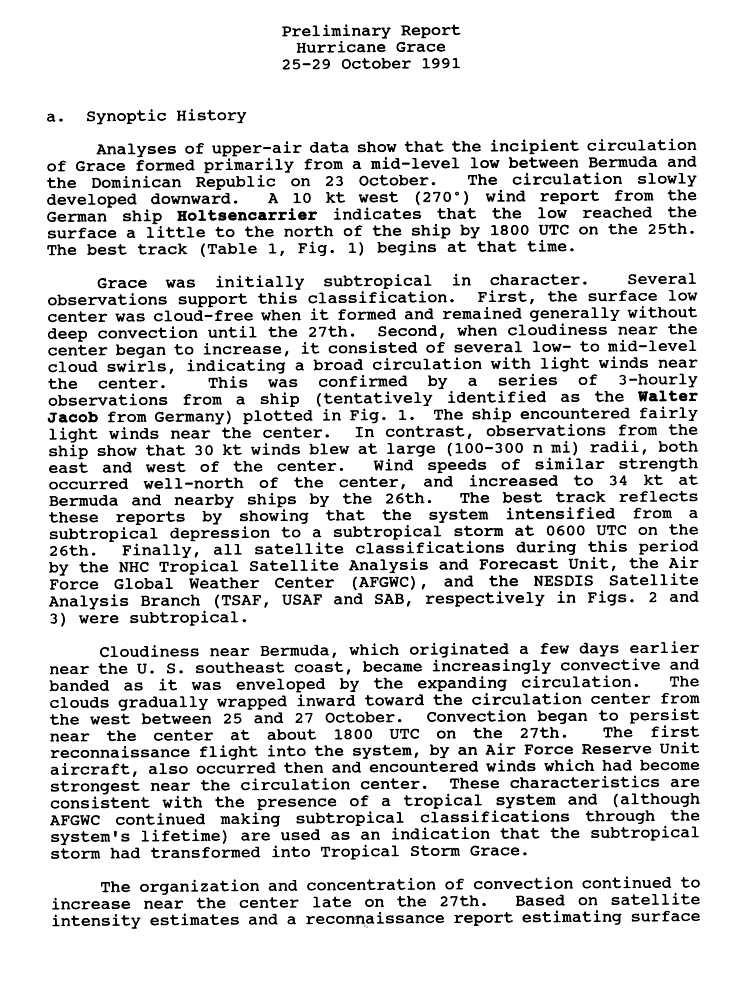
The 1991 Atlantic hurricane season was the first season since 1984 in which no hurricanes developed from tropical waves, which are the source for most North Atlantic tropical cyclones. The hurricane season officially began on June 1, and ended on November 30. It was the least active in four years due to higher than usual wind shear across the Atlantic Ocean. The first storm, Ana, developed on July 2 off the southeast United States and dissipated without causing significant effects. Two other tropical storms in the season – Danny and Erika – did not significantly affect land. Danny dissipated east of the Lesser Antilles, and Erika passed through the Azores before becoming extratropical. In addition, there were four non-developing tropical depressions. The second depression of the season struck Mexico with significant accompanying rains.

The 1991 Pacific typhoon season was a slightly above-average season with 29 tropical storms, 17 typhoons and five super typhoons forming. It was quite a catastrophic season – Typhoon Yunya impacted the Philippines in mid June while in the same time experiencing a volcanic eruption, Typhoon Mireille severely impacting Japan, which became known for being the costliest typhoon on record until it was surpassed by Typhoon Doksuri in 2023, and Tropical Storm Thelma on November which became one of the deadliest storms to strike the Philippines, killing at least over 5,000 people.

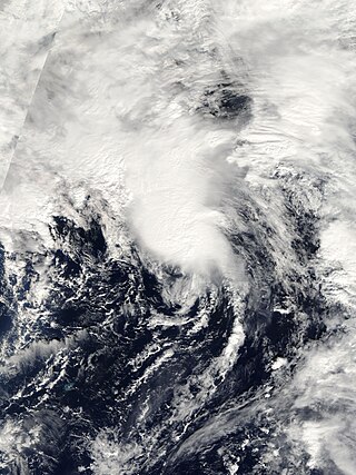
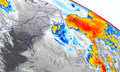
The 1991 Perfect Storm, also known as The No-Name Storm and the Halloween Gale/Storm, was a damaging and deadly nor'easter in October 1991. Initially an extratropical cyclone, the storm absorbed Hurricane Grace to its south and evolved into a small unnamed hurricane later in its life. Damage from the storm totaled over $200 million and thirteen people were killed in total, six of which were an outcome of the sinking of Andrea Gail, which inspired the book and later movie, The Perfect Storm. The nor'easter received the name, playing off the common expression, after a conversation between Boston National Weather Service forecaster Robert Case and author Sebastian Junger.

Hurricane Gert was the fourth of five major hurricanes in the moderately active 1999 Atlantic hurricane season. A Cape Verde hurricane, Gert formed on September 11 off the coast of Africa before heading west-northwest. It reached a peak wind speed of 150 mph (240 km/h) by September 15 over the open central Atlantic east-northeast of the Leeward Islands. It gradually curved to the northwest and later to the north, due to a weakness in the subtropical ridge created by Hurricane Floyd. Hurricane Gert passed east of Bermuda on September 21 and began a steady weakening trend at that time. It turned to the northeast, and on September 23, Gert transitioned into an extratropical cyclone to the southeast of Atlantic Canada before being absorbed by a larger storm.
Subtropical Storm Nicole was the first subtropical storm to receive a name using the standard hurricane name list that did not become a tropical cyclone. The fifteenth tropical or subtropical cyclone and fourteenth named storm of the 2004 Atlantic hurricane season, Nicole developed on October 10 near Bermuda from a broad surface low that developed as a result of the interaction between an upper level trough and a decaying cold front. The storm turned to the northeast, passing close to Bermuda as it intensified to reach peak winds of 50 mph (80 km/h) on October 11. Deep convection developed near the center of the system as it attempted to become a fully tropical cyclone. However, it failed to do so and was absorbed by an extratropical cyclone late on October 11.

Hurricane Karen was a hurricane of non-tropical origin that formed in October of the 2001 Atlantic hurricane season. It developed out of the interaction between a cold front and an upper level trough on October 10 located to the south of Bermuda, and quickly strengthened as an extratropical storm. The storm passed near Bermuda on October 12, producing hurricane-force winds on the island. It then organized, becoming a subtropical cyclone on October 12 and a tropical cyclone on October 13. Karen strengthened to reach 80 mph (130 km/h) winds as a Category 1 hurricane on the Saffir-Simpson Hurricane Scale, and after weakening over cooler waters, it made landfall on Nova Scotia as a tropical storm. It quickly became extratropical.
Hurricane Bonnie was a long-lived storm in the 1992 Atlantic hurricane season. It was the third tropical or subtropical storm and second hurricane of the 1992 season. Bonnie formed at high latitudes in the central Atlantic on September 17. Devoid of any real steering currents for much of its lifespan, it was nearly stationary for over a week in the central Atlantic Ocean. On September 27, it began to slowly track east and northeast towards the Azores. Just before becoming extratropical, it affected the Azores on September 30, although no damage was reported.
Hurricane Tanya was the first named storm to start with a "T" in the Atlantic since naming began in 1950, and the final storm of the very active 1995 Atlantic hurricane season. The twenty-first tropical cyclone, nineteenth named storm, and eleventh hurricane of the season, Tanya developed from a tropical wave while well north of the Lesser Antilles on October 26. The system headed northeastward and strengthened into Tropical Storm Tanya on October 27. Tanya meandered around the central Atlantic, and further intensified into a hurricane on October 29. Thereafter, Tanya tracked northeastward before curving to the east-northeast. After switching to an eastward direction, Tanya weakened to a tropical storm on November 1. Later that day, Tanya passed through the Azores as it was transitioning into an extratropical cyclone.

Hurricane Florence was a strong, late season hurricane that remained out over the open waters of the Atlantic Ocean for nearly a week, before being absorbed into a large extratropical cyclone. With peak winds of 110 mph (180 km/h) and a minimum pressure of 972 mbar, Florence was the strongest storm of the 1994 Atlantic hurricane season. Florence developed out of an area of low pressure associated with a stalled frontal system located 1,150 mi (1,850 km) east-southeast of Bermuda in late October. The system gradually became better organized and was classified a subtropical depression on November 2. The storm intensified into a subtropical storm shortly thereafter before weakening into a tropical depression on the next day.

The 1994 Atlantic hurricane season was the final season in the most recent negative Atlantic multidecadal oscillation period of tropical cyclone formation within the basin. The season produced seven named tropical cyclones and three hurricanes, a total well below the seasonal average. The season officially started on June 1 and ended on November 30, dates which conventionally limit the period each year when most tropical cyclones tend to form in the Atlantic Ocean. The first tropical cyclone, Tropical Storm Alberto, developed on June 30, while the last storm, Hurricane Gordon, dissipated on November 21. The season was unusual in that it produced no major hurricanes, which are those of Category 3 status or higher on the Saffir–Simpson hurricane scale. The most intense hurricane, Hurricane Florence, peaked as a Category 2 storm with winds of 110 mph (180 km/h).

The 2009 Atlantic hurricane season was a near-average Atlantic hurricane season that produced eleven tropical cyclones, nine named storms, three hurricanes, and two major hurricanes. It officially began on June 1 and ended on November 30, dates that conventionally delimit the period of each year when most tropical cyclones develop in the Atlantic basin. The season's first tropical cyclone, Tropical Depression One, developed on May 28, while the final storm, Hurricane Ida, dissipated on November 10. The most intense hurricane, Bill, was a powerful Cape Verde-type hurricane that affected areas from the Leeward Islands to Newfoundland. The season featured the lowest number of tropical cyclones since the 1997 season, and only one system, Claudette, made landfall in the United States. Forming from the interaction of a tropical wave and an upper-level low, Claudette made landfall on the Florida Panhandle with maximum sustained winds of 45 mph (70 km/h) before quickly dissipating over Alabama. The storm killed two people and caused $228,000 in damage.
The 2021 Atlantic hurricane season was the third-most active Atlantic hurricane season on record in terms of number of tropical cyclones, although many of them were weak and short-lived. With 21 named storms forming, it became the second season in a row and third overall in which the designated 21-name list of storm names was exhausted. Seven of those storms strengthened into a hurricane, four of which reached major hurricane intensity, which is slightly above-average. The season officially began on June 1 and ended on November 30. These dates historically describe the period in each year when most Atlantic tropical cyclones form. However, subtropical or tropical cyclogenesis is possible at any time of the year, as demonstrated by the development of Tropical Storm Ana on May 22, making this the seventh consecutive year in which a storm developed outside of the official season.
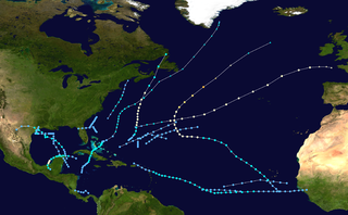
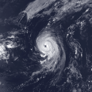
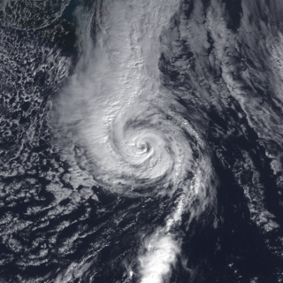
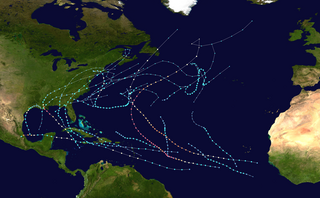
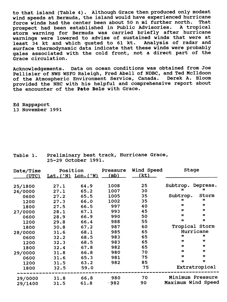
The 1991 Atlantic hurricane season was a below-average Atlantic hurricane season that produced twelve tropical cyclones, of which eight strengthened to become named tropical storms; four of these became hurricanes, of which two further intensified into major hurricanes. The season officially began on June 1, 1991, and ended on November 30. These dates, adopted by convention, historically describe the period in each year when most subtropical or tropical cyclogenesis occurs in the Atlantic Ocean. The first system, Tropical Storm Ana, developed on July 2 while the last system, the unnamed Perfect Storm, dissipated on November 2.

