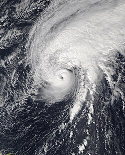
Hurricane Tammy

Last updated

Map key
  Tropical depression (≤38 mph, ≤62 km/h)
  Tropical storm (39–73 mph, 63–118 km/h)
  Category 1 (74–95 mph, 119–153 km/h)
  Category 2 (96–110 mph, 154–177 km/h)
  Category 3 (111–129 mph, 178–208 km/h)
  Category 4 (130–156 mph, 209–251 km/h)
  Category 5 (≥157 mph, ≥252 km/h)
  Unknown
Storm type
Disc Plain black.svg Tropical cyclone
Solid black.svg Subtropical cyclone
ArrowUp.svg Extratropical cyclone, remnant low, tropical disturbance, or monsoon depression

On October 11, the National Hurricane Center (NHC) began monitoring a tropical wave located wave just offshore of West Africa. [2] Showers and thunderstorms associated with the disturbance became more concentrated and better organized on October 14, [3] but nearby dry air managed to infiltrate the system, suppressing convection to some degree. [4] Later, when environmental conditions became more conducive, thunderstorm activity within the disturbance was able to become more organized on October 17. [5] The following afternoon, satellite imagery indicated a well-defined low-level surface circulation, prompting the NHC to designate the system as Tropical Storm Tammy. [6] Despite having a sheared appearance due to light to moderate westerly vertical wind shear, hurricane hunter data indicated that Tammy was strengthening as it moved quickly westward through record-warm sea surface temperatures towards the Leeward Islands on October 19. [7] [8] The following morning on October 20, Tammy's inner core became better organized the following morning. Radar imagery showed that strong convection had quickly evolved into a curved band, and a closed eye. Meanwhile, aircraft data showed that its central pressure had fallen quickly, and sustained winds increased. As a result, the storm was upgraded to a Category 1 hurricane. [9] Later, Tammy passed to the east-southeast of Guadeloupe, [10] and then at 01:15 UTC on October 22, made landfall on Barbuda at its initial peak intensity with sustained winds of 90 mph (150 km/h). [11]

Hurricane Tammy nearing Barbuda on October 21 Tammy 2023-10-21 1400Z.jpg
Hurricane Tammy nearing Barbuda on October 21

Tammy pulled away from the Leeward Islands throughout the day, though heavy rains still impacted the islands. [12] After weakening to a minimal hurricane while struggling against wind shear for a couple of days, Tammy began to strengthen on October 25 due to increasing upper-level divergence associated with a deep-layer trough. [13] Later that day, it intensified into a Category 2 hurricane and reached its peak intensity with maximum sustained winds of 110 mph (175 km/h). [14] Shortly after peaking, Tammy then began to interact with a front to its north, which caused the hurricane to begin its transition to an extratropical cyclone. It did not fully merge with the front and remained a tropical cyclone, although operationally the NHC declared it extratropical on October 26, [15] then restarted advisories on October 27 east of Bermuda. [16] Not long afterward though, environmental conditions became adverse. Strong vertical wind shear and dry air entrainment quickly stripped the storm of its convection, and it became a remnant low on October 29. [17]

Preparations and impacts

Caribbean

Hurricane warnings were issued for Antigua and Barbuda, Guadeloupe, Montserrat, Saint Kitts and Nevis, Anguilla, Saint Martin, and Saint Barthélemy. [18] Sint Maarten closed their airport and businesses and the Ministry of Defense requested for soldiers to aid citizens after Tammy passed. [19] Prime Minister Silveria Jacobs requested people to shelter in place. [19] [20] The island kept its schools closed till October 23. [21] The British Virgin Islands cleaned roadways. The people of the islands stockpiled of supplies. District representatives were given permission to issue emergency crews in their districts. [22]

Rainfall amounts across the islands were between 4 and 8 in (100 and 200 mm), and storm surge heights were between 1 and 3 ft (0.30 and 0.91 m). [23] Though in close proximity to the storm, Dominica did not experienced hurricane strength winds. [18] Some landslides did occur due to intense rains from Tammy. [23] Sint Maartin and Sint Eustatius only experienced heavy rains and cloud cover. [19] In the aftermath, Sint Maarten still had experienced some flooded roads and rough surf. [24]

Guadeloupe

Wind field history of Tammy from October 18-29. Despite its close proximity to the Leeward Islands, hurricane-force winds did not generally affect the area due to the cyclone's small size. Tammy 2023 wind history.png
Wind field history of Tammy from October 18–29. Despite its close proximity to the Leeward Islands, hurricane-force winds did not generally affect the area due to the cyclone's small size.

Guadeloupe issued a vigilance violet, schools were closed and movement prohibited. [25] An emergency shelter was opened up in Guadeloupe. [26] The island mobilized 600 gendarmes, 200 firefighters, and a hundred police. [25]

The principle islands of Guadeloupe were not impacted with the strongest winds from Tammy. [18] However, La Désirade experienced winds of 90 miles per hour (140 km/h) that caused moderate damage with numerous uprooted trees, some roof damage and traffic signs washed away; [27] also, up to 80% of the island was in a blackout during the peak of the hurricane. [28] Debris were also found across La Desirade, and was mostly the sum of all the damages from Tammy on the island. [29] According to Météo-France, 3.7 inches (94 mm) of rain fell in Saint-Claude and Vieux-Habitants, 3.3 inches (84 mm) in Capesterre-Belle-Eau, and 3.1 inches (79 mm) in Sainte-Anne and Petit-Bourg. [25] Rivers in southern Basse-Terre left their courses, most notably Grande Ravine in Le Gosier, Baie-Mahault, Sainte-Marie de Capesterre-Belle-Eau, and Petit-Bourg; Grande Rivière à Goyaves and the Géry in Vieux-Habitants. Trois-Rivières, Baillif, Vieux-Fort, and the River Sens in Gourbeyre had river flooding up to their piers. [30] A landslip occurred in Saint-Claude that carried cars 30 meters (98 ft) down a hill and buried them. [31] Potable water plants went out of circuit and power outages were reported. [28]

Antigua and Barbuda

Tammy made landfall on Barbuda, the second system in two weeks to do so, in addition to Tropical Storm Philippe. [32] Barbuda was left with minimal damage. [33] At least two families had to be evacuated. Meanwhile, on Antigua, the only damages reported were broken branches and powerlines. Blackouts occurred across both islands, but mostly on Barbuda where the entire island experienced a blackout. [34]

Bermuda

Bermuda was buffeted with wind gusts of 40 mph (65 km/h) late on October 26, [35] resulting in the issuing of a gale warning. [36]

Elsewhere

The East Coast of the United States was impacted with minor swells due to a large pressure gradient from Tammy and a high-pressure on the East Coast. [37]

See also

Notes

  1. This excludes a retroactively recognized and unnamed subtropical storm in January.

Related Research Articles

<span class="mw-page-title-main">1995 Atlantic hurricane season</span> Hurricane season in the Atlantic Ocean

The 1995 Atlantic hurricane season was a very active Atlantic hurricane season, and is considered to be the start of an ongoing era of high-activity tropical cyclone formation. The season produced twenty-one tropical cyclones, nineteen named storms, as well as eleven hurricanes and five major hurricanes. The season officially began on June 1 and ended on November 30, dates which conventionally delimit the period of each year when most tropical cyclones develop in the Atlantic basin. The first tropical cyclone, Hurricane Allison, developed on June 2, while the season's final storm, Hurricane Tanya, transitioned into an extratropical cyclone on November 1. The very active Atlantic hurricane activity in 1995 was caused by La Niña conditions, which also influenced an inactive Pacific hurricane season. It was tied with 1887 Atlantic hurricane season with 19 named storms, which was later equalled by the 2010, 2011, and 2012 seasons.

<span class="mw-page-title-main">Hurricane Luis</span> Category 4 Atlantic hurricane in 1995

Hurricane Luis was a long lived and powerful Category 4 hurricane. It was the strongest hurricane to make landfall and the third-most intense hurricane recorded during the 1995 Atlantic hurricane season. The storm, along with Humberto, Iris, and Karen, was one of four simultaneous tropical systems in the Atlantic basin.

<span class="mw-page-title-main">Hurricane Jose (1999)</span> Category 2 Atlantic hurricane in 1999

Hurricane Jose was the fourteenth tropical cyclone, tenth named storm, and seventh hurricane of the annual hurricane season that caused moderate damage in the Lesser Antilles in October 1999. Jose developed from a tropical wave several hundred miles east of the Windward Islands on October 17. The depression intensified and was subsequently upgraded to Tropical Storm Jose on October 18. The storm tracked northwestward and was upgraded to a hurricane the following day as it approached the northern Leeward Islands. Jose briefly peaked as a Category 2 hurricane with winds of 100 mph (160 km/h) on October 20. However, wind shear weakened the storm back to a Category 1 hurricane before it struck Antigua. Further deterioration occurred and Jose weakened to a tropical storm before landfall in Tortola on October 21. While located north of Puerto Rico on October 22, the storm turned northward, shortly before curving north-northeastward. Wind shear decreased, allowing Jose to re-intensify into a hurricane while passing east of Bermuda on October 24. However, on the following day, wind shear increased again, while sea surface temperatures decreased, causing Jose to weaken and quickly transition into an extratropical cyclone.

<span class="mw-page-title-main">Hurricane Debby (2000)</span> Category 1 Atlantic hurricane in 2000

Hurricane Debby caused minor damage in the Greater and Lesser Antilles in August 2000. The seventh tropical cyclone, fourth named storm, and second hurricane of the annual season, Debby developed from a tropical wave east of the Lesser Antilles on August 19. Favorable conditions allowed the depression to become Tropical Storm Debby early on August 20, and further strengthening into a hurricane occurred 24 hours later. Sustained winds peaked at 85 mph (137 km/h) on August 21. Debby made three landfalls on August 22, in Barbuda, Saint Barthélemy, and Virgin Gorda, before re-entering the Atlantic north of Puerto Rico. As Debby moved parallel to the north coast of Hispaniola late on August 23, it weakened back to a tropical storm. The storm tracked westward and weakened further, instead of approaching Florida and strengthening into a major hurricane. While south of eastern Cuba on August 24, Debby was downgraded to a tropical depression, six hours before completely dissipating.

<span class="mw-page-title-main">2012 Pacific hurricane season</span> Hurricane season in the Pacific Ocean

The 2012 Pacific hurricane season was a moderately active Pacific hurricane season that saw an unusually high number of tropical cyclones pass west of the Baja California Peninsula. The season officially began on May 15 in the eastern Pacific Ocean, and on June 1 in the central Pacific (from 140°W to the International Date Line, north of the equator; they both ended on November 30. These dates conventionally delimit the period of each year when most tropical cyclones form in these regions of the Pacific Ocean. However, the formation of tropical cyclones is possible at any time of the year. This season's first system, Tropical Storm Aletta, formed on May 14, and the last, Tropical Storm Rosa, dissipated on November 3.

<span class="mw-page-title-main">Tropical Storm Erika (2009)</span> Atlantic tropical storm in 2009

Tropical Storm Erika was a short-lived tropical cyclone that brought minor impacts to the Lesser Antilles. The fifth named storm of the 2009 Atlantic hurricane season, Erika originated out of a tropical wave on September 1 near the Lesser Antilles. Although it was a disorganized system, it was immediately declared a tropical storm, rather than a tropical depression. Later that day, the system reached its peak intensity with winds of 50 mph (85 km/h) and a barometric pressure of 1004 mbar. Increased wind shear caused the storm to weaken shortly thereafter, with Erika barely maintaining tropical storm-status by September 2. Later that day, the storm passed over the island of Guadeloupe and entered the Caribbean Sea. On September 3, Erika weakened to a tropical depression as the low pressure center became fully displaced from convective activity. Later that day, the system degenerated into a remnant low before dissipating near Puerto Rico on September 4.

<span class="mw-page-title-main">2016 Pacific hurricane season</span> Hurricane season in the Pacific Ocean

The 2016 Pacific hurricane season was tied as the fifth-most active Pacific hurricane season on record, alongside the 2014 season. Throughout the course of the year, a total of 22 named storms, 13 hurricanes and six major hurricanes were observed within the basin. Although the season was very active, it was considerably less active than the previous season, with large gaps of inactivity at the beginning and towards the end of the season. It officially started on May 15 in the Eastern Pacific, and on June 1 in the Central Pacific ; they both ended on November 30. These dates conventionally delimit the period of each year when most tropical cyclones form in these regions of the Pacific Ocean. However, tropical development is possible at any time of the year, as demonstrated by the formation of Hurricane Pali on January 7, the earliest Central Pacific tropical cyclone on record. After Pali, however, no tropical cyclones developed in either region until a short-lived depression on June 6. Also, there were no additional named storms until July 2, when Tropical Storm Agatha formed, becoming the latest first-named Eastern Pacific tropical storm since Tropical Storm Ava in 1969.

<span class="mw-page-title-main">2017 Pacific hurricane season</span> Hurricane season in the Pacific Ocean

The 2017 Pacific hurricane season was an above average Pacific hurricane season in terms of named storms, though less active than the previous three, featuring eighteen named storms, nine hurricanes, and four major hurricanes. Despite the considerable amount of activity, most of the storms were weak and short-lived. The season officially started on May 15 in the eastern Pacific Ocean, and on June 1 in the central Pacific; they both ended on November 30. These dates conventionally delimit the period of each year when most tropical cyclones form in the respective regions. However, the formation of tropical cyclones is possible at any time of the year, as illustrated in 2017 by the formation of the season's first named storm, Tropical Storm Adrian, on May 9. At the time, this was the earliest formation of a tropical storm on record in the eastern Pacific basin proper. The season saw near-average activity in terms of accumulated cyclone energy (ACE), in stark contrast to the extremely active seasons in 2014, 2015, and 2016; and for the first time since 2012, no tropical cyclones formed in the Central Pacific basin. However, for the third year in a row, the season featured above-average activity in July, with the ACE value being the fifth highest for the month. Damage across the basin reached $375.28 million (2017 USD), while 45 people were killed by the various storms.

<span class="mw-page-title-main">Hurricane Katia (2011)</span> Category 4 Atlantic hurricane in 2011

Hurricane Katia was a fairly intense Cape Verde hurricane that had substantial impact across Europe as a post-tropical cyclone. The eleventh named storm, second hurricane, and second major hurricane of the active 2011 Atlantic hurricane season, Katia originated as a tropical depression from a tropical wave over the eastern Atlantic on August 29. It intensified into a tropical storm the following day and further developed into a hurricane by September 1, although unfavorable atmospheric conditions hindered strengthening thereafter. As the storm began to recurve over the western Atlantic, a more hospitable regime allowed Katia to become a major hurricane by September 5 and peak as a Category 4 hurricane with winds of 140 mph (230 km/h) that afternoon. Internal core processes, increased wind shear, an impinging cold front, and increasingly cool ocean temperatures all prompted the cyclone to weaken almost immediately after peak, and Katia ultimately transitioned into an extratropical cyclone on September 10.

<span class="mw-page-title-main">2017 Atlantic hurricane season</span> Hurricane season in the Atlantic Ocean

The 2017 Atlantic hurricane season was a devastating, extremely active Atlantic hurricane season and the costliest on record, with a damage total of at least $294.92 billion (USD). The season featured 17 named storms, 10 hurricanes, and 6 major hurricanes. Most of the season's damage was due to hurricanes Harvey, Irma, and Maria. Another notable hurricane, Nate, was the worst natural disaster in Costa Rican history. These four storm names were retired following the season due to the number of deaths and amount of damage they caused.

<span class="mw-page-title-main">Hurricane Danny (2015)</span> Category 3 Atlantic hurricane in 2015

Hurricane Danny was the first major hurricane to develop between the Lesser Antilles and Western Africa since Hurricane Julia in 2010. The fourth tropical cyclone, and first hurricane of the 2015 Atlantic hurricane season, Danny originated from a well-defined tropical wave that emerged over the Atlantic Ocean on August 14. Traveling west, the system gradually coalesced into a tropical depression by August 18. After becoming a tropical storm later that day, dry air slowed further development. On August 20–21, dry air became removed from the system, and Danny rapidly intensified into a Category 3 hurricane on the Saffir–Simpson hurricane wind scale. Its peak was short-lived as wind shear soon increased and prompted significant weakening. Degrading to a tropical storm by August 23, Danny approached the Lesser Antilles. It degenerated into a tropical wave as it traversed the archipelago on August 24 and was last noted over Hispaniola the following day.

<span class="mw-page-title-main">2023 Atlantic hurricane season</span> Atlantic hurricane season

The 2023 Atlantic hurricane season was the fourth-most active Atlantic hurricane season on record with 20 named storms forming, tied with 1933. Among them, 7 became hurricanes, with 3 reaching major hurricane strength. The season also had an above‑normal accumulated cyclone energy (ACE) rating of 146, despite the presence of the ongoing 2023–24 El Niño event, which typically results in less activity, and had the most storms for an El Niño year on record, largely due to record-warm sea surface temperatures across the Atlantic. The season officially began on June 1 and ended on November 30. These dates, adopted by convention, historically describe the period in each year when most tropical cyclogenesis occurs in the Atlantic. However, the formation of subtropical or tropical cyclones is possible at any time of the year, as demonstrated by the formation of a subtropical storm on January 16, the earliest start of an Atlantic hurricane season since Hurricane Alex in January 2016. At the time, the system was assessed as non-tropical by the National Hurricane Center (NHC), resulting in it staying unnamed.

<span class="mw-page-title-main">2021 Atlantic hurricane season</span> Hurricane season in the Atlantic Ocean

The 2021 Atlantic hurricane season was the third-most active Atlantic hurricane season on record in terms of number of tropical cyclones, although many of them were weak and short-lived. With 21 named storms forming, it became the second season in a row and third overall in which the designated 21-name list of storm names was exhausted. Seven of those storms strengthened into a hurricane, four of which reached major hurricane intensity, which is slightly above-average. The season officially began on June 1 and ended on November 30. These dates historically describe the period in each year when most Atlantic tropical cyclones form. However, subtropical or tropical cyclogenesis is possible at any time of the year, as demonstrated by the development of Tropical Storm Ana on May 22, making this the seventh consecutive year in which a storm developed outside of the official season.

<span class="mw-page-title-main">Hurricane Genevieve (2020)</span> Category 4 Pacific hurricane in 2020

Hurricane Genevieve was a strong tropical cyclone that almost made landfall on the Baja California Peninsula in August 2020. Genevieve was the twelfth tropical cyclone, eighth named storm, third hurricane, and second major hurricane of the 2020 Pacific hurricane season. The cyclone formed from a tropical wave that the National Hurricane Center (NHC) first started monitoring on August 10. The wave merged with a trough of low pressure on August 13, and favorable conditions allowed the wave to intensify into Tropical Depression Twelve-E at 15:00 UTC. Just six hours later, the depression became a tropical storm and was given the name Genevieve. Genevieve quickly became a hurricane by August 17, and Genevieve began explosive intensification the next day. By 12:00 UTC on August 18, Genevieve reached its peak intensity as a Category 4 hurricane, with maximum 1-minute sustained winds of 130 mph and a minimum central pressure of 950 millibars (28 inHg). Genevieve began to weaken on the next day, possibly due to cooler waters caused by Hurricane Elida earlier that month. Genevieve weakened below tropical storm status around 18:00 UTC on August 20, as it passed close to Baja California Sur. Soon afterward, Genevieve began to lose its deep convection and became a post-tropical cyclone by 21:00 UTC on August 21, eventually dissipating off the coast of Southern California late on August 24.

<span class="mw-page-title-main">2023 Pacific hurricane season</span> Hurricane season in the Pacific Ocean

The 2023 Pacific hurricane season was an active and destructive Pacific hurricane season. In the Eastern Pacific basin, 17 named storms formed; 10 of those became hurricanes, of which 8 strengthened into major hurricanes – double the seasonal average. In the Central Pacific basin, no tropical cyclones formed, though four entered into the basin from the east. Collectively, the season had an above-normal accumulated cyclone energy (ACE) value of approximately 164 units. This season saw the return of El Niño and its associated warmer sea surface temperatures in the basin, which fueled the rapid intensification of several powerful storms. It officially began on May 15, 2023 in the Eastern Pacific, and on June 1 in the Central; both ended on November 30. These dates, adopted by convention, historically describe the period in each year when most tropical cyclogenesis occurs in these regions of the Pacific.

<span class="mw-page-title-main">Hurricane Epsilon (2020)</span> Category 3 Atlantic hurricane in 2020

Hurricane Epsilon was a strong tropical cyclone that affected Bermuda, and parts of North America and Western Europe. The twenty-seventh tropical or subtropical cyclone, twenty-sixth named storm, eleventh hurricane, and fourth major hurricane of the extremely-active 2020 Atlantic hurricane season, Epsilon had a non-tropical origin, developing from an upper-level low off the East Coast of the United States on October 13. The low gradually organized, becoming Tropical Depression Twenty-Seven on October 19, and six hours later, Tropical Storm Epsilon. The storm executed a counterclockwise loop before turning westward, while strengthening. On October 20, Epsilon began undergoing rapid intensification, becoming a Category 1 hurricane on the next day, before peaking as a Category 3 major hurricane on October 22, with maximum 1-minute sustained winds of 115 mph (185 km/h) and a minimum central pressure of 952 millibars (28.1 inHg). This made Epsilon the easternmost major hurricane this late in the calendar year, as well as the strongest late-season major hurricane in the northeastern Atlantic, and the fastest recorded case of a tropical cyclone undergoing rapid intensification that far northeast that late in the hurricane season. Afterward, Epsilon began to weaken as the system turned northward, with the storm dropping to Category 1 intensity late that day. Epsilon maintained its intensity as it moved northward, passing to the east of Bermuda. On October 24, Epsilon turned northeastward and gradually accelerated, before weakening into a tropical storm on the next day. On October 26, Epsilon transitioned into an extratropical cyclone, before being absorbed by another larger extratropical storm later that same day.

<span class="mw-page-title-main">Tropical Storm Fred (2021)</span> Atlantic tropical storm in 2021

Tropical Storm Fred was a strong tropical storm which affected much of the Greater Antilles and the Southeastern United States in August 2021. The sixth tropical storm of the 2021 Atlantic hurricane season, Fred originated from a tropical wave first noted by the National Hurricane Center on August 4. As the wave drifted westward, advisories were initiated on the wave as a potential tropical cyclone by August 9 as it was approaching the Leeward Islands. Entering the Eastern Caribbean Sea after a close pass to Dominica by the next day, the potential tropical cyclone continued northwestward. By August 11, the disturbance had formed into Tropical Storm Fred just south of Puerto Rico, shortly before hitting the Dominican Republic on the island of Hispaniola later that day. The storm proceeded to weaken to a tropical depression over the highly mountainous island, before emerging north of the Windward Passage on August 12. The disorganized tropical depression turned to the west and made a second landfall in Northern Cuba on August 13. After having its circulation continuously disrupted by land interaction and wind shear, the storm degenerated into a tropical wave as it was turning northward near the western tip of Cuba the following day. Continuing north, the remnants of Fred quickly re-organized over the Gulf of Mexico, regenerating into a tropical storm by August 15. Fred continued towards the Florida Panhandle and swiftly intensified to a strong 65 mph (105 km/h) tropical storm before making landfall late on August 16 and moving into the state of Georgia. Afterward, Fred continued moving north-northeastward, before degenerating into an extratropical low on August 18. Fred's remnants later turned eastward, and the storm's remnants dissipated on August 20, near the coast of Massachusetts.

<span class="mw-page-title-main">Hurricane Bonnie (2022)</span> Category 3 Atlantic and Pacific hurricane in 2022

Hurricane Bonnie was a strong tropical cyclone that survived the crossover from the Atlantic Ocean to the Pacific Ocean, the first to do so since Hurricane Otto in 2016. The second named storm of the 2022 Atlantic hurricane season, it originated from a strong tropical wave that moved off the west coast of Africa on June 23. Moving with little development despite favorable conditions, the National Hurricane Center (NHC) started advisories on it as Potential Tropical Cyclone Two late on June 27, due to its imminent threat to land. The disturbance finally organized into Tropical Storm Bonnie at 13:15 UTC on July 1, and made brief landfalls on the Costa Rica–Nicaragua border with winds of 50 miles per hour (80 km/h). It later became the fourth named storm, third hurricane, and first major hurricane of the 2022 Pacific hurricane season after crossing Nicaragua and Costa Rica from east to west on July 2 and intensifying to a Category 3 hurricane on July 5. Bonnie rapidly weakened, dissipating over the North Pacific.

<span class="mw-page-title-main">Timeline of the 2023 Atlantic hurricane season</span>

The 2023 Atlantic hurricane season saw an above average number of named storms and an average number of hurricanes and major hurricanes. There were twenty named storms during the season; seven of them strengthened into hurricanes, and three of those reached major hurricane intensity. The season officially began on June 1, 2023, and ended on November 30. These dates, adopted by convention, historically describe the period in each year when most subtropical or tropical cyclones form in the Atlantic. However, tropical cyclone formation is possible at any time of the year, as was the case this season, when an unnamed subtropical storm formed on January 16. The last system to dissipate was Hurricane Tammy, on October 28.

<span class="mw-page-title-main">Tropical Storm Philippe (2023)</span> Atlantic tropical storm in 2023

Tropical Storm Philippe was a long-lived but weak and poorly organized tropical cyclone which affected the Caribbean, Maine, and Canada during September and October 2023. The sixteenth named storm of the 2023 Atlantic hurricane season, Philippe formed from a tropical wave on September 23, near Cabo Verde. The storm brought heavy rainfall to the northern Leeward Islands, before transitioning to a post-tropical cyclone on October 6, south of Bermuda. After passing the islands, the extratropical low hit New England and the Maritimes on October 7 and 8, then entered Quebec, where it was absorbed by another frontal system.

References

  1. "Hurricane Tammy Tracking North After Impacting The Northeast Caribbean Islands". The Weather Channel. October 22, 2023. Retrieved October 22, 2023.
  2. Blake, Eric (October 11, 2023). Tropical Weather Outlook (Report). Miami, Florida: National Hurricane Center. Retrieved October 18, 2023.
  3. Kelly, Larry (October 14, 2023). Tropical Weather Outlook (Report). Miami, Florida: National Hurricane Center. Retrieved October 18, 2023.
  4. Henson, Bob (October 13, 2023). "The next Atlantic system may threaten the Lesser Antilles". New Haven, Connecticut: Yale Climate Connections. Retrieved October 18, 2023.
  5. Blake, Eric (October 17, 2023). Tropical Weather Outlook (Report). Miami, Florida: National Hurricane Center. Retrieved October 18, 2023.
  6. Berg, Robbie (October 18, 2023). Tropical Storm Tammy Discussion Number 1 (Report). Miami, Florida: National Hurricane Center. Retrieved October 21, 2023.
  7. Masters, Jeff; Henson, Bob (October 19, 2023). "Norma and Tammy gain strength en route to Mexico, Leeward Islands". New Haven, Connecticut: Yale Climate Connections. Retrieved October 19, 2023.
  8. Brown, Daniel. "Tropical Storm Tammy Tropical Cyclone Update". www.nhc.noaa.gov. National Hurricane Center. Retrieved October 19, 2023.
  9. Brown, Daniel (October 20, 2023). Hurricane Tammy Discussion Number 9 (Report). Miami, Florida: National Hurricane Center. Retrieved October 20, 2023.
  10. Cangialosi, John (October 21, 2023). Hurricane Tammy Discussion Number 13 (Report). Miami, Florida: National Hurricane Center. Retrieved October 22, 2023.
  11. Kelly, Larry; Pasch, Richard (October 21, 2023). Hurricane Tammy Tropical Cyclone Update (Report). Miami, Florida: National Hurricane Center. Retrieved October 22, 2023.
  12. Cangialosi, John (October 22, 2023). "Hurricane Tammy Discussion Number 18". National Hurricane Center. Retrieved October 22, 2023.
  13. Reinhart, Brad (October 25, 2023). "Hurricane Tammy Discussion Number 27". National Hurricane Center. Retrieved October 26, 2023.
  14. Bucci, Lisa; Zelinsky, Rachel. "Hurricane Tammy Discussion Number 29". National Hurricane Center. Retrieved October 24, 2023.
  15. Kelly, Larry. "Post-Tropical Cyclone Tammy Discussion Number 32". National Hurricane Center. Retrieved October 27, 2023.
  16. Pasch, Richard (October 27, 2023). Tropical Storm Tammy Discussion Number 33 (Report). Miami, Florida: National Hurricane Center. Retrieved October 27, 2023.
  17. Cangialosi, John (October 29, 2023). Hurricane Tammy Discussion Number 40 (Report). Miami, Florida: National Hurricane Center. Retrieved October 30, 2023.
  18. 1 2 3 Cangialosi, John (October 21, 2023). "Hurricane Tammy Advisory Number 14". National Hurricane Center. Retrieved October 22, 2023.
  19. 1 2 3 "Orkaan Tammy passeert Sint-Maarten zonder grote schade: 'Had erger kunnen zijn'". NOS (in Dutch). October 22, 2023. Retrieved November 12, 2023.
  20. Written at Binneland. "Orkaan Tammy onderweg naar Sint-Maarten, eiland zet zich schrap". De Telegraaf. Philipsburg. October 22, 2023. Retrieved November 12, 2023.
  21. "Large waves pound the northern Caribbean as Hurricane Tammy spins into open waters". ABC News. October 23, 2023. Retrieved October 30, 2023.
  22. "Tammy, the hurricane that never was! | Virgin Islands News Online". Virgin Islands news online. October 22, 2023. Retrieved January 13, 2024.
  23. 1 2 "Hurricane Tammy - Final Situation Report (11:00 AM on October 22, 2023) - Anguilla". reliefweb. October 22, 2023. Retrieved October 23, 2023.
  24. "Orkaan Tammy zorgt voor nattigheid op Sint Maarten". Paradise FM 103.1 (in Dutch). October 23, 2023. Retrieved November 20, 2023.
  25. 1 2 3 Hübsch, Sarah (October 22, 2023). "L'ouragan Tammy a touché les Petites Antilles". Microsoft Start (in Canadian French). Retrieved October 30, 2023.
  26. "Sint-Maarten zet zich schrap voor orkaan Tammy: winkels en luchthaven dicht". NOS (in Dutch). October 22, 2023. Retrieved November 12, 2023.
  27. Fadel, Nadine (October 21, 2023). "Ouragan Tammy : les plaies infligées à La Désirade". Outre-mer (in French). Retrieved October 29, 2023.
  28. 1 2 "Après l'ouragan Tammy, la Guadeloupe a subi pluies et inondations". TV5 Monde (in French). October 22, 2023. Archived from the original on October 27, 2023. Retrieved October 29, 2023.
  29. "Ouragan Tammy : plus de peur que de mal en Guadeloupe, après quelques heures de confinement". Libération (in French). October 22, 2023. Retrieved November 9, 2023.
  30. "Ouragan Tammy : inondations et routes impraticables en Guadeloupe". franceinfo (in French). Guadeloupe. October 22, 2023. Retrieved November 1, 2023.
  31. Theatin, Laurence (October 27, 2023). "Hurricane Tammy: devastating floods in Guadeloupe". France 24. Retrieved November 1, 2023.
  32. "Hurricanes Norma and Tammy make landfall on Saturday in Mexico and Barbuda". The Independent. October 22, 2023. Retrieved October 22, 2023.
  33. "Norma downgraded to a tropical storm in Mexico as Hurricane Tammy leaves Barbuda". KVIA. October 22, 2023. Retrieved October 22, 2023.
  34. Martinez, Ignacio (October 22, 2023). "Norma downgraded to a tropical storm in Mexico as Hurricane Tammy leaves Barbuda". ABC News. Cabo San Lucas . Retrieved October 23, 2023.
  35. Sosnowski, Alex (October 26, 2023). "Tammy tracking away from Bermuda after impacting the islands with tropical-storm force wind gusts". Accuweather . Retrieved October 28, 2023.
  36. "Tammy has redeveloped into a tropical storm over the Atlantic Ocean, forecasters say". AP News. Miami. October 27, 2023. Retrieved October 28, 2023.
  37. McCloud, Cheryl (October 26, 2023). "Tammy weakens into post-tropical cyclone but is still packing hurricane-force winds". Daytona Beach News-Journal Online. Retrieved November 4, 2023.
Hurricane Tammy
Tammy 2023-10-25 1650Z.jpg
Tammy at peak intensity north of the Leeward Islands on October 25