Baillif

Last updated
Baillif
Tour du Pere-Labat 09.JPG
The tower of Father Labat, an historic monument
Baillif.PNG
Location of the commune (in red) within Guadeloupe
Location of Baillif
Baillif
Coordinates: 16°01′N61°45′W / 16.02°N 61.75°W / 16.02; -61.75
Country France
Overseas region and department Guadeloupe
Arrondissement Basse-Terre
Canton Vieux-Habitants
Intercommunality CA Grand Sud Caraïbe
Government
  Mayor (20202026) Marie-Yveline Ponchateau-Théobald [1]
Area
1
24.30 km2 (9.38 sq mi)
Population
 (Jan. 2020) [2]
5,122
  Density210/km2 (550/sq mi)
Demonym Baillifien
Time zone UTC−04:00 (AST)
INSEE/Postal code
97104 /97123
Elevation0–1,354 m (0–4,442 ft)
(avg. 15 m or 49 ft)
1 French Land Register data, which excludes lakes, ponds, glaciers > 1 km2 (0.386 sq mi or 247 acres) and river estuaries.

Baillif (French pronunciation: [bajif] ; Guadeloupean Creole : Bayif) is a commune of Guadeloupe, an overseas region and department of France located in the Lesser Antilles. Baillif is a suburb of Basse-Terre, the prefecture and second-largest urban area of Guadeloupe located on Basse-Terre Island (the western-half of Guadeloupe).

Contents

History

In 1637, Governor De L'Olive conceded a parcel of land to the Dominican friars, from the Fathers' river to that of Baillif, and today these mark out the boundary of the town. Under the leadership of Father Labat, several fortresses were built in Baillif to protect the region from English invasion. The Dominicans came to preach the good news of Jesus.

Following the defeat of Napoleon in the Napoleonic Wars in 1815, the governor of Guadeloupe, the Comte de Linois refused to surrender his position to the Bourbon appointed governor of the Windward Islands, the Comte de Vaugiraud, believing the stories of Napoleon's defeat to be propaganda and lies. As such, de Vaugiraud invited the English to invade the island. The ensuing battle on August 8 between the joint Bourbon and English invasion force against the Napoleonic garrison took place at Baillif. In which the Napoleonic loyalists where defeated forcing Linois to capitulate. [3]

The Airfield, as seen towards the sea. Runway 32 Baillif Airfield.jpg
The Airfield, as seen towards the sea. Runway 32

The commune is named after an early inhabitant, Robert Baillif. Baillif traded in the area from 1650 to about 1700. Today, Baillif is often considered to be a suburb of the prefecture of Guadeloupe, Basse-Terre, and with its small regional airfield, it acts as a gateway to the islands in the south. Marie-Yveline Théobald-Ponchateau was elected mayor (maire) of Baillif in 2020.

Geography

Baillif is situated on the south-west coast of Basse-Terre Island and it covers an area of 24.3 km2 (9.4 sq mi). It faces the Caribbean Sea. The town is west of Basse-Terre's mountain range. The capital of Guadeloupe, Basse-Terre, is south of Baillif, and Vieux-Habitants, a village, is located north. La riviere de Père flows halfway between Baillif and Basse-Terre.

Climate

Like any other Eastern Caribbean settlement, Baillif experiences quite evenly spread rainfall during the year, with a wetter season between July and November which coincides with hurricane season. Guadeloupe has been struck by many hurricanes which have caused devastation. The town receives below 1500 mm of rainfall. Tropical heat is the norm, bringing constant highs of around 32 °C (89 °F) that drop to 20 °C (68 °F) at night.

Trade winds, called alizés, blow from the northeast and often temper the climate.

Population

The inhabitants are called Baillifiens in French.

Historical population
YearPop.±% p.a.
1967 5,214    
1974 5,847+1.65%
1982 5,612−0.51%
1990 6,004+0.85%
1999 5,837−0.31%
2007 5,836−0.00%
2012 5,287−1.96%
2017 5,605+1.18%
Source: INSEE [4]

Economy

Baillif has mainly an agricultural sector a. Mixed crops such as bananas, cocoa and coffee are grown. They are shipped to the port or the airport to be transported. Baillif has an airport, Baillif Airport & the runway is 2,034 ft (620 m) and the International Civil Aviation Organization airport code is TFFB & the International Air Transport Association airport code is BBR.

Today, an industrial and commercial zone is under development, supplementing the Jarry zone.

Sights

With its small regional airfield, it acts as a gateway to the islands in the south. The airport from 19 October 2019 is now French language only for arriving and departing traffic.

At the entry to the market town, there is a 4 m tower as evidence of this historical past called the “Père Labat Tower”.

Further while going towards Vieux-Habitants, is the “engraved rocks” of Plessis.

Education

Public preschools and primary schools include: [5]

Public junior high schools include: [6]

Personalities

See also

Related Research Articles

<span class="mw-page-title-main">Basse-Terre</span> Prefecture and commune in Guadeloupe, France

Basse-Terre is a commune in the French overseas department of Guadeloupe, in the Lesser Antilles. It is also the prefecture of Guadeloupe. The city of Basse-Terre is located on Basse-Terre Island, the western half of Guadeloupe.

<span class="mw-page-title-main">Baie-Mahault</span> Commune in Guadeloupe, France

Baie-Mahault is a commune in the overseas department and region of Guadeloupe, France. It is the second most populated commune of Guadeloupe, after Les Abymes. The extensive industrial zone of Jarry in Baie-Mahault is by far the most industrialized commune in the islands and the largest industrial park in the Lesser Antilles. It is part of the urban area of Pointe-à-Pitre, the largest metropolitan area in Guadeloupe, located in the northwest.

<span class="mw-page-title-main">Bouillante</span> Commune in Guadeloupe, France

Bouillante is a commune in the French overseas region and department of Guadeloupe, in the Lesser Antilles.

<span class="mw-page-title-main">Deshaies</span> Commune in Guadeloupe, France

Deshaies is a commune in the French overseas region and department of Guadeloupe, in the Lesser Antilles. It is on the northwest coast of Basse-Terre Island.

<span class="mw-page-title-main">Capesterre-Belle-Eau</span> Commune in Guadeloupe, France

Capesterre-Belle-Eau is a commune in the French overseas region and department of Guadeloupe, in the Lesser Antilles. It is located in the south-east of Basse-Terre Island. Capesterre-Belle-Eau covers an area of 103.3 km2. The 1999 population was 19,568. The population density is 189 persons per km2. The inhabitants are called Capesterriens.

<span class="mw-page-title-main">Pointe-à-Pitre</span> Subprefecture, commune, and the center of the largest metropolitan area in Guadeloupe

Pointe-à-Pitre is the second largest city of Guadeloupe after Les Abymes. Guadeloupe is an overseas region and department of France located in the Lesser Antilles, of which it is a sous-préfecture, being the seat of the Arrondissement of Pointe-à-Pitre.

<span class="mw-page-title-main">Arrondissement of Basse-Terre</span> Arrondissement in Guadeloupe, France

The arrondissement of Basse-Terre is an arrondissement of France in the Guadeloupe department in the Guadeloupe region. It has 18 communes. Its population is 189,210 (2016), and its area is 854.3 km2 (329.8 sq mi).

<span class="mw-page-title-main">Petit-Bourg</span> Commune in Guadeloupe, France

Petit-Bourg is the seventh-largest commune in the French overseas department of Guadeloupe. It is located on the east side of the island of Basse-Terre, and is part of the metropolitan area of Pointe-à-Pitre, the largest metropolitan area in Guadeloupe.

<span class="mw-page-title-main">Gourbeyre</span> Commune in Guadeloupe, France

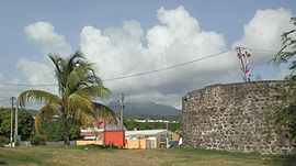
Gourbeyre is a commune in the French overseas region and department of Guadeloupe, in the Lesser Antilles. It is a suburb of the city of Basse-Terre.

<span class="mw-page-title-main">Vieux-Habitants</span> Commune in Guadeloupe, France

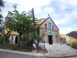
Vieux-Habitants is a commune on Guadeloupe, a French overseas department in the Caribbean. It is located on the southwest coast of the island of Basse-Terre.

<span class="mw-page-title-main">Goyave</span> Commune in Guadeloupe, France

Goyave is a commune in the French overseas region and department of Guadeloupe, Lesser Antilles. It is part of the urban area of Pointe-à-Pitre, the largest metropolitan area in Guadeloupe.

<span class="mw-page-title-main">Lamentin</span> Commune in Guadeloupe, France

Lamentin is a commune in the French overseas department and region of Guadeloupe. It is part of the agglomeration of Pointe-à-Pitre, in the north part of Basse-Terre. Three islets are included in the commune: Christopher, Fajou, Caret.

<span class="mw-page-title-main">Saint-Claude, Guadeloupe</span> Commune in Guadeloupe, France

Saint-Claude is a commune in the French overseas department of Guadeloupe. It lies in the interior of southern Basse-Terre Island, just northeast of the capital city of Basse-Terre.

<span class="mw-page-title-main">Morne-à-l'Eau</span> Commune in Guadeloupe, France

Morne-à-l'Eau is a commune located in the department of Guadeloupe.

<span class="mw-page-title-main">Sainte-Rose, Guadeloupe</span> Commune in Guadeloupe, France

Sainte-Rose is a commune in the department of Guadeloupe. It is the second largest commune of Guadeloupe, in terms of area, after Petit-Bourg. Sainte-Rose lies on the coast of the island of Basse-Terre.

<span class="mw-page-title-main">Terre-de-Haut</span> Commune in Guadeloupe, France

Terre-de-Haut is a commune in the French overseas department of Guadeloupe, including Terre-de-Haut Island and a few other small uninhabited islands of the archipelago. It is the most populous island of the archipelago of Les Saintes. The Fort Napoléon is located in this commune.

<span class="mw-page-title-main">Trois-Rivières, Guadeloupe</span> Commune in Guadeloupe, France

Trois-Rivières is a commune in the overseas department of Guadeloupe, and the chef-lieu of the Canton of Trois-Rivières. It is on the south coast of the island of Basse-Terre. It is surrounded with the towns of Capesterre-Belle-Eau, Vieux-Fort and Gourbeyre.

<span class="mw-page-title-main">Vieux-Fort, Guadeloupe</span> Commune in Guadeloupe, France

Vieux-Fort is a commune in the French overseas department of Guadeloupe. It is located on Basse-Terre Island.
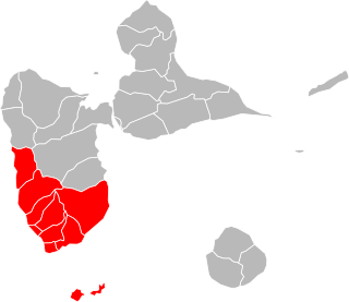
<span class="mw-page-title-main">Index of Guadeloupe-related articles</span>

Articles related to the French overseas department of Guadeloupe include:

<span class="mw-page-title-main">Invasion of Guadeloupe (1815)</span>

The Invasion of Guadeloupe was the last conflict between French and British forces during the Napoleonic Wars, and took place after Napoleon's defeat at Waterloo.
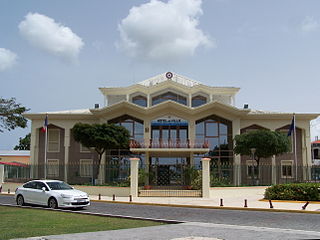
References

  1. "Répertoire national des élus: les maires" (in French). data.gouv.fr, Plateforme ouverte des données publiques françaises. 13 September 2022.
  2. "Populations légales 2020". The National Institute of Statistics and Economic Studies. 29 December 2022.
  3. Haggard, Denis (Winter 1935). "The Last Fight for Napoleon". Journal of the Society for Army Historical Research. XIV (56): 231–232.
  4. Population en historique depuis 1968, INSEE
  5. "LISTE DES ECOLES PUBLIQUES ET PRIVEES SOUS CONTRAT." Académie de la Guadeloupe  [ fr ]. Retrieved on 10 March 2018.
  6. "Établissements du 2nd degré PUBLIC 2017-2018 Archived 2018-03-07 at the Wayback Machine ." Académie de la Guadeloupe  [ fr ]. Retrieved on 10 March 2018.